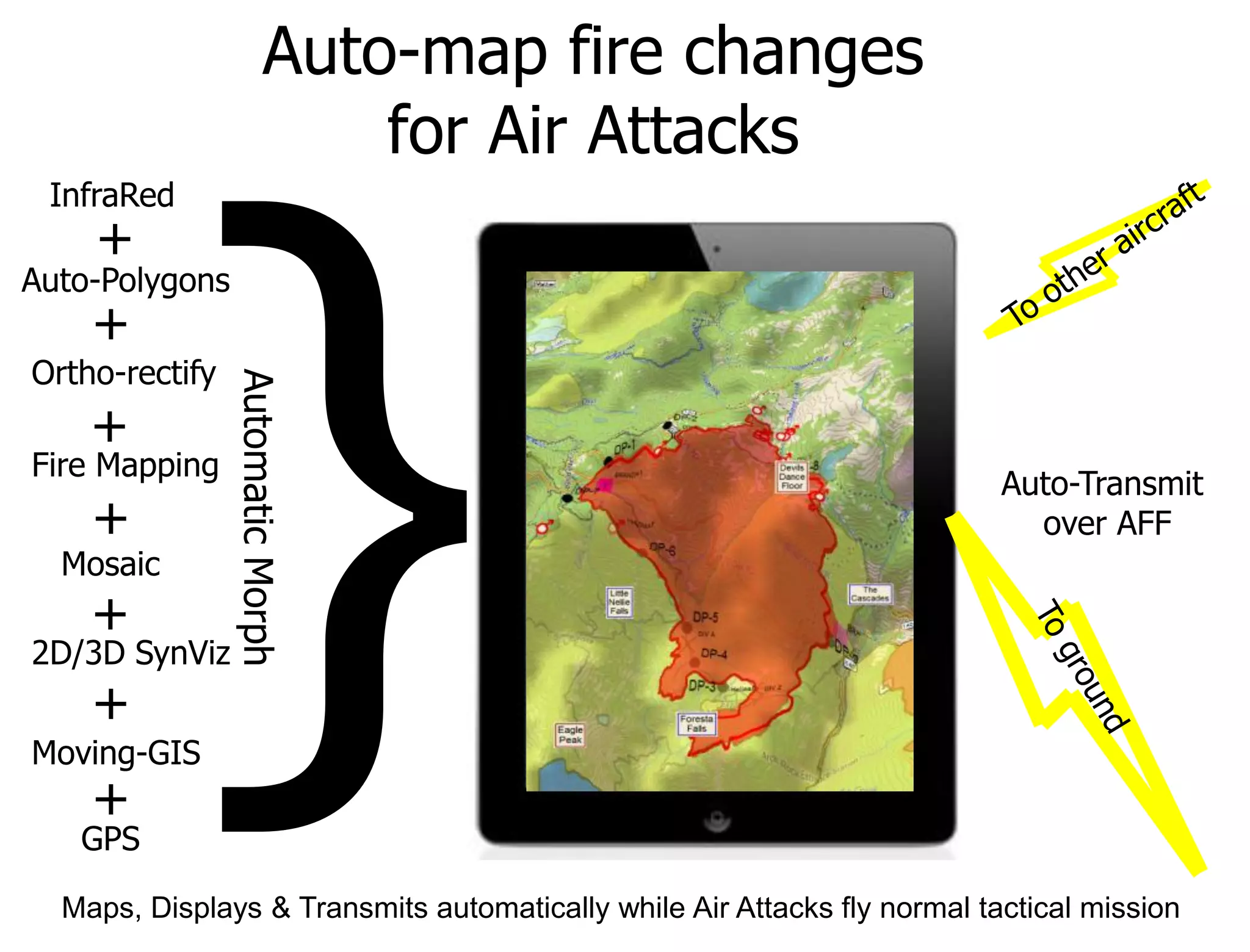
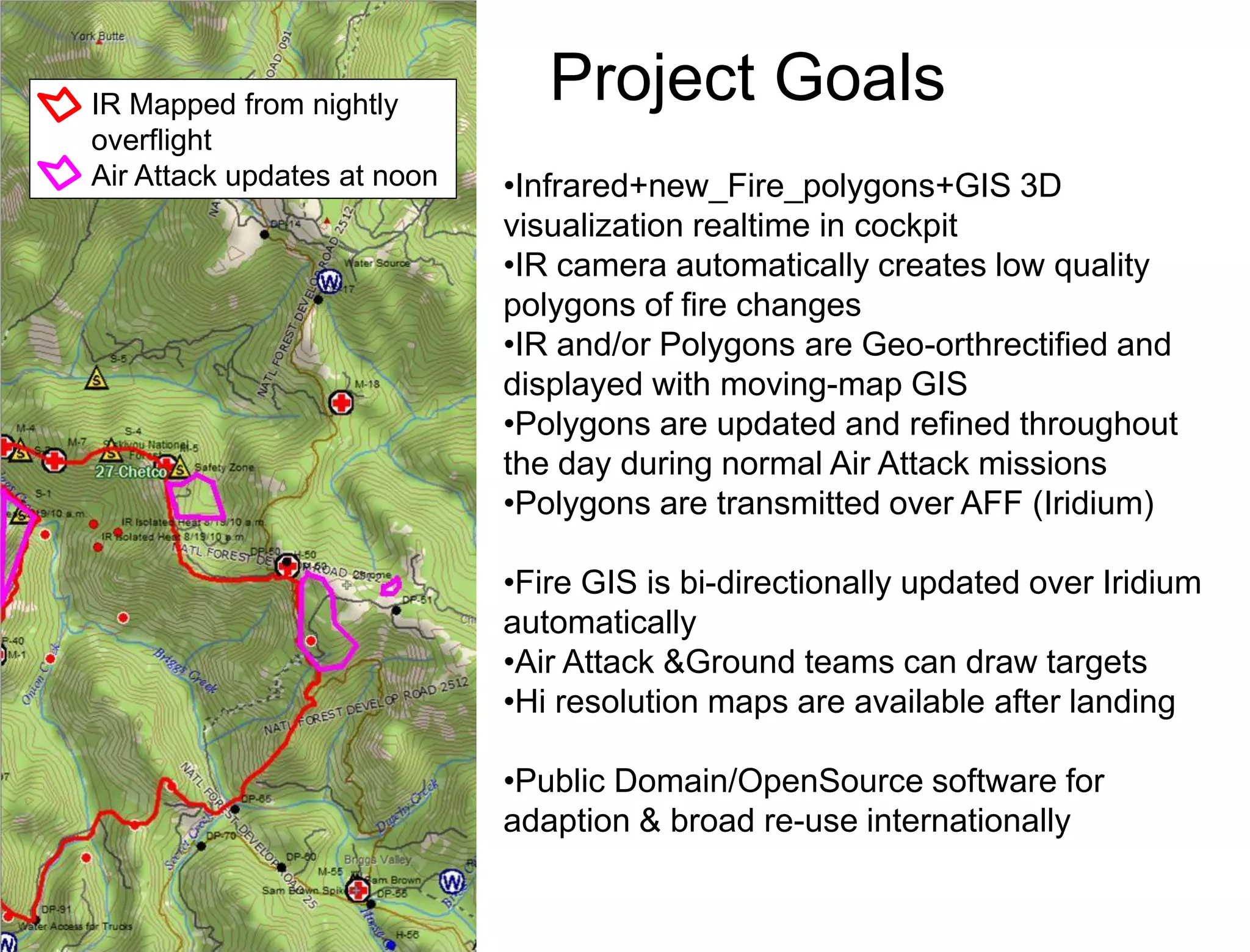
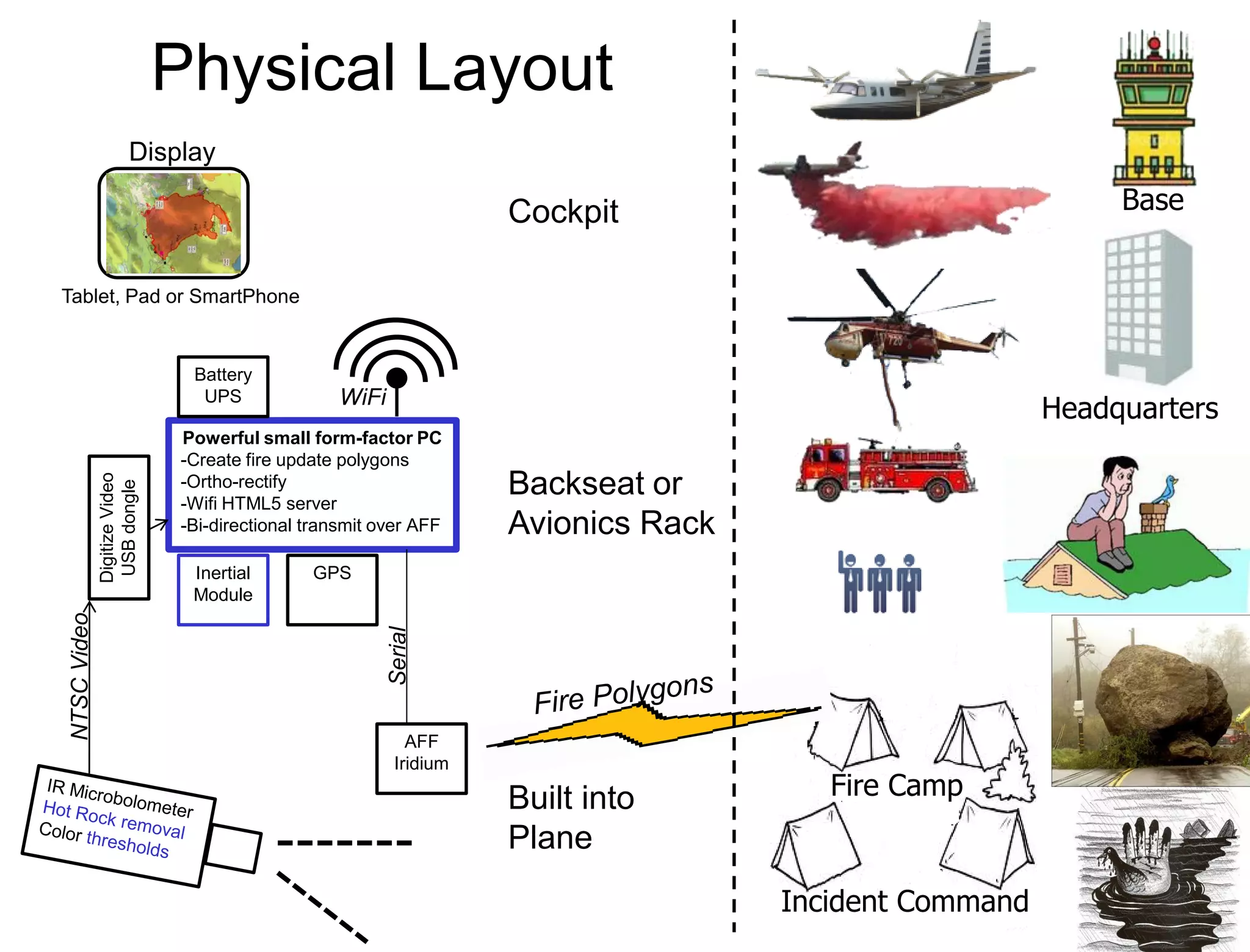
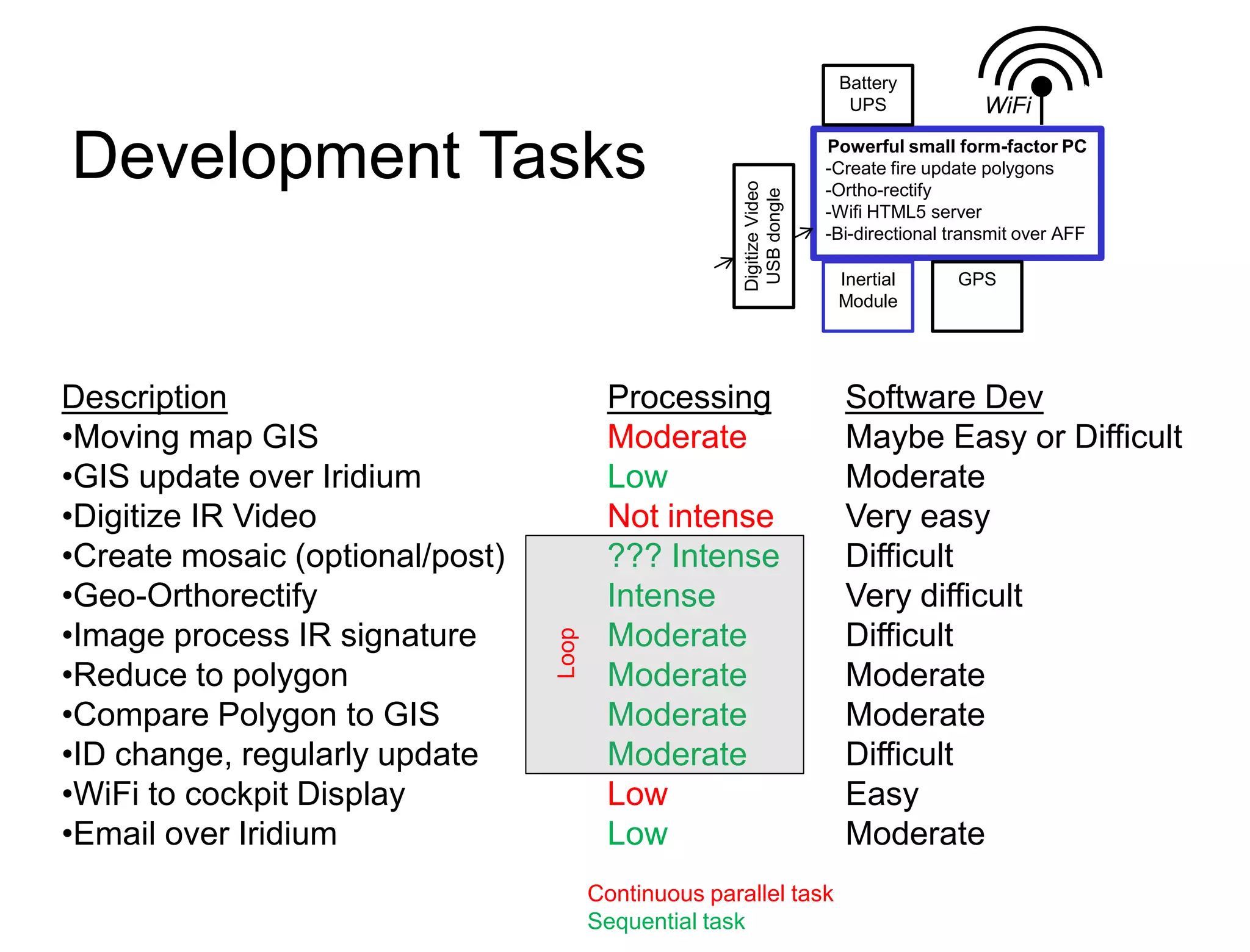
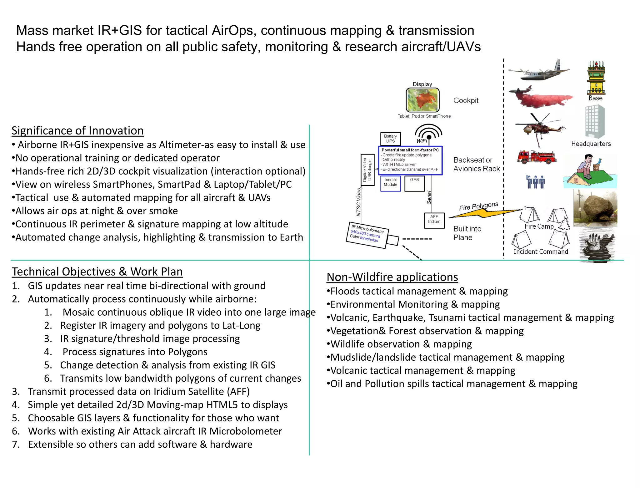
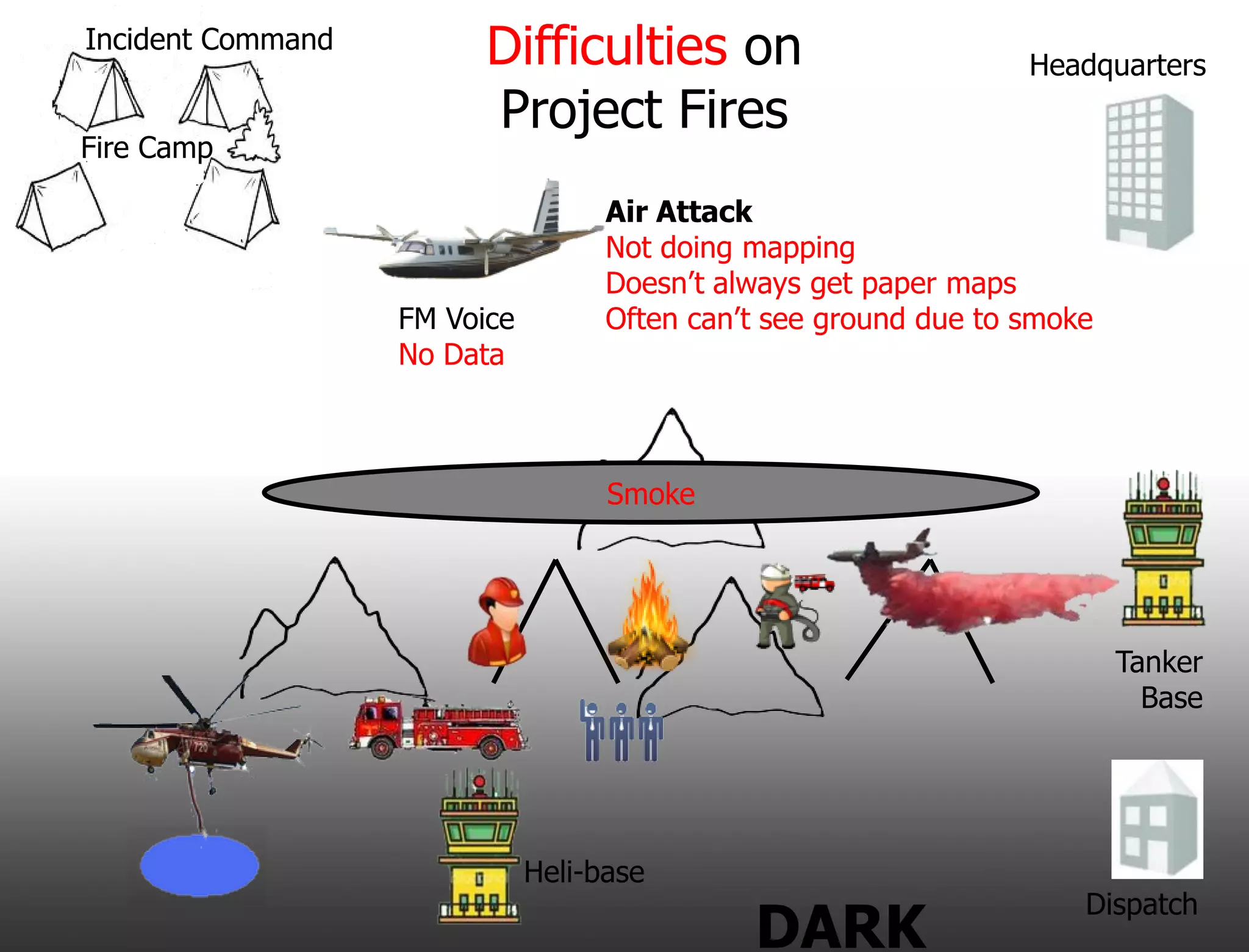
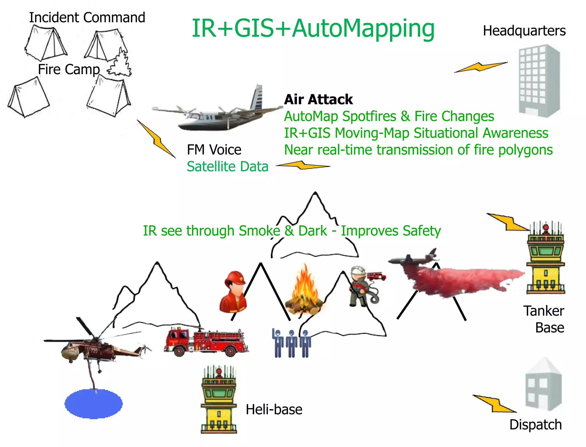
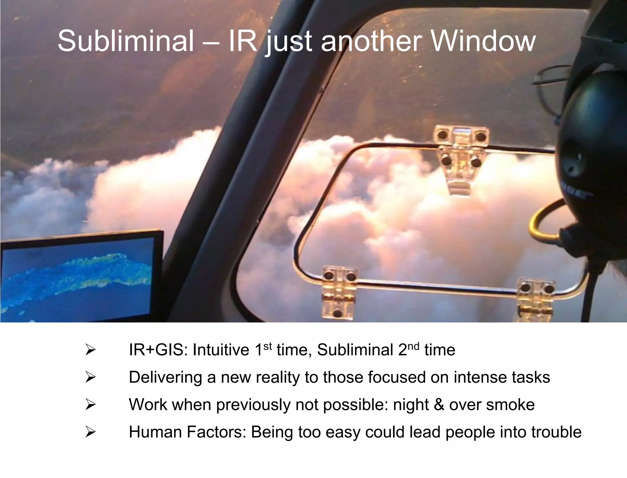
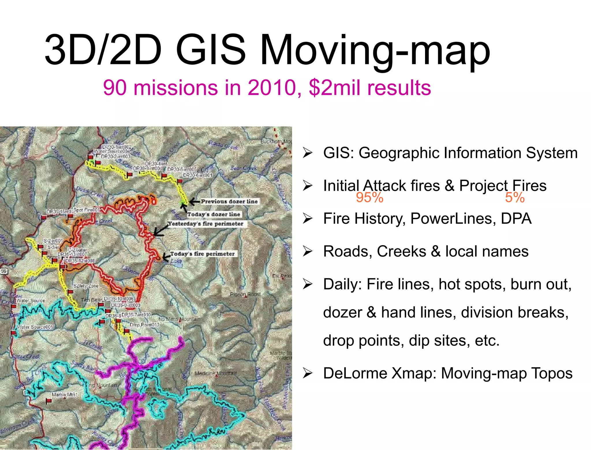
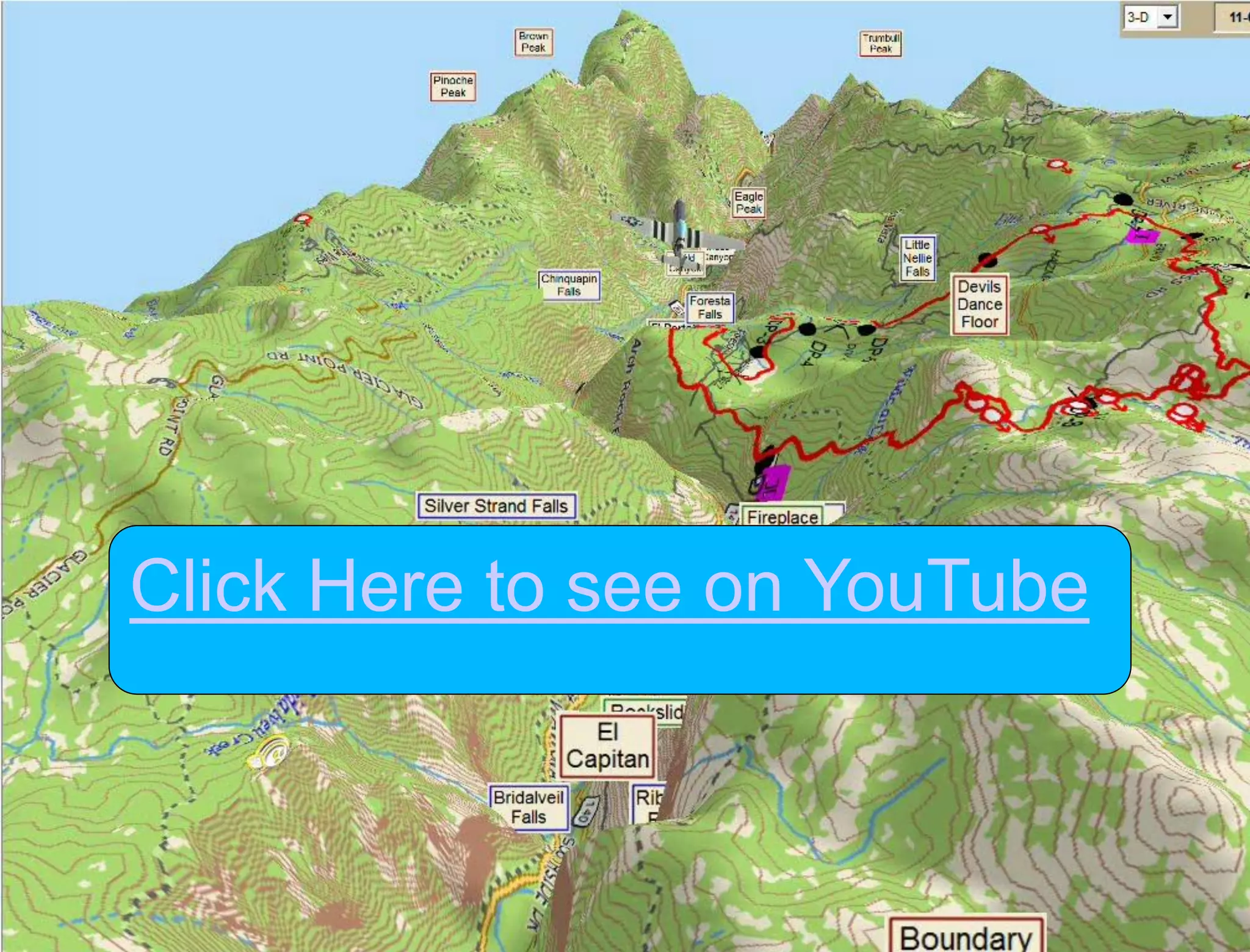
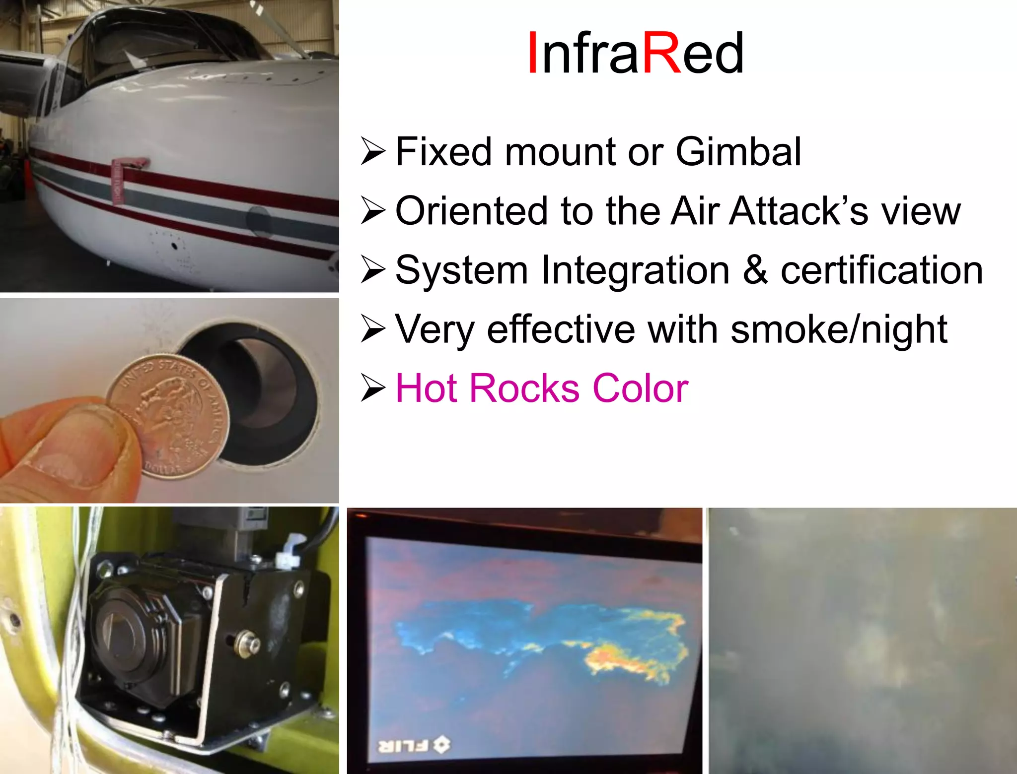
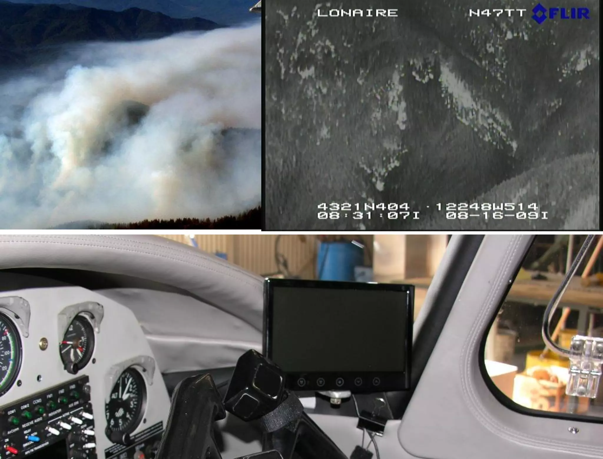
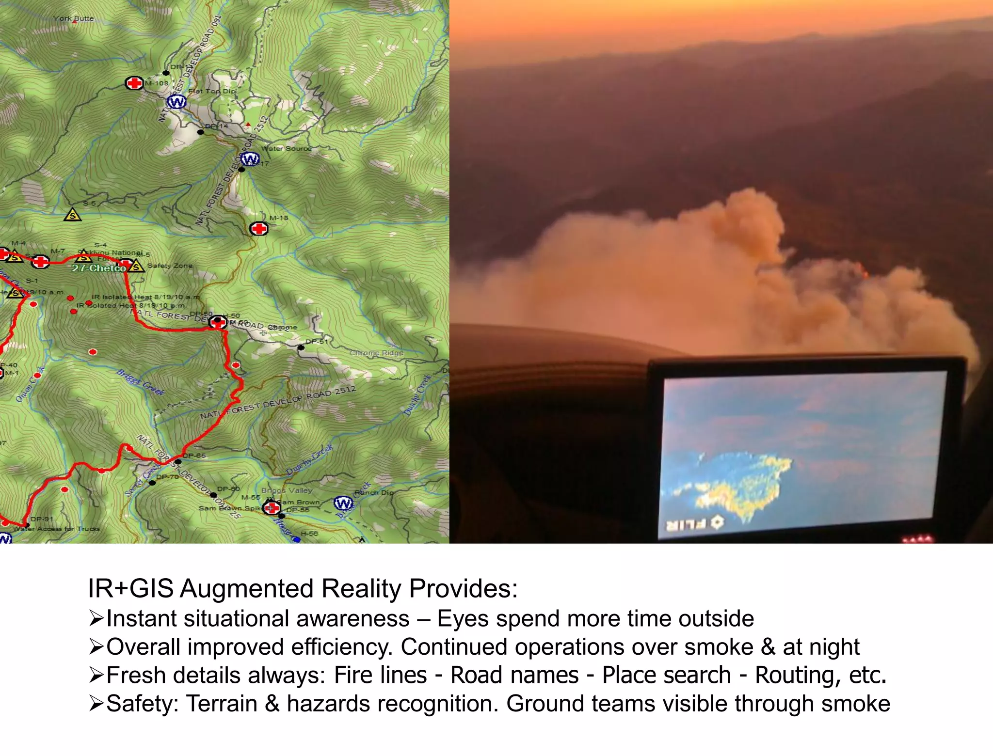
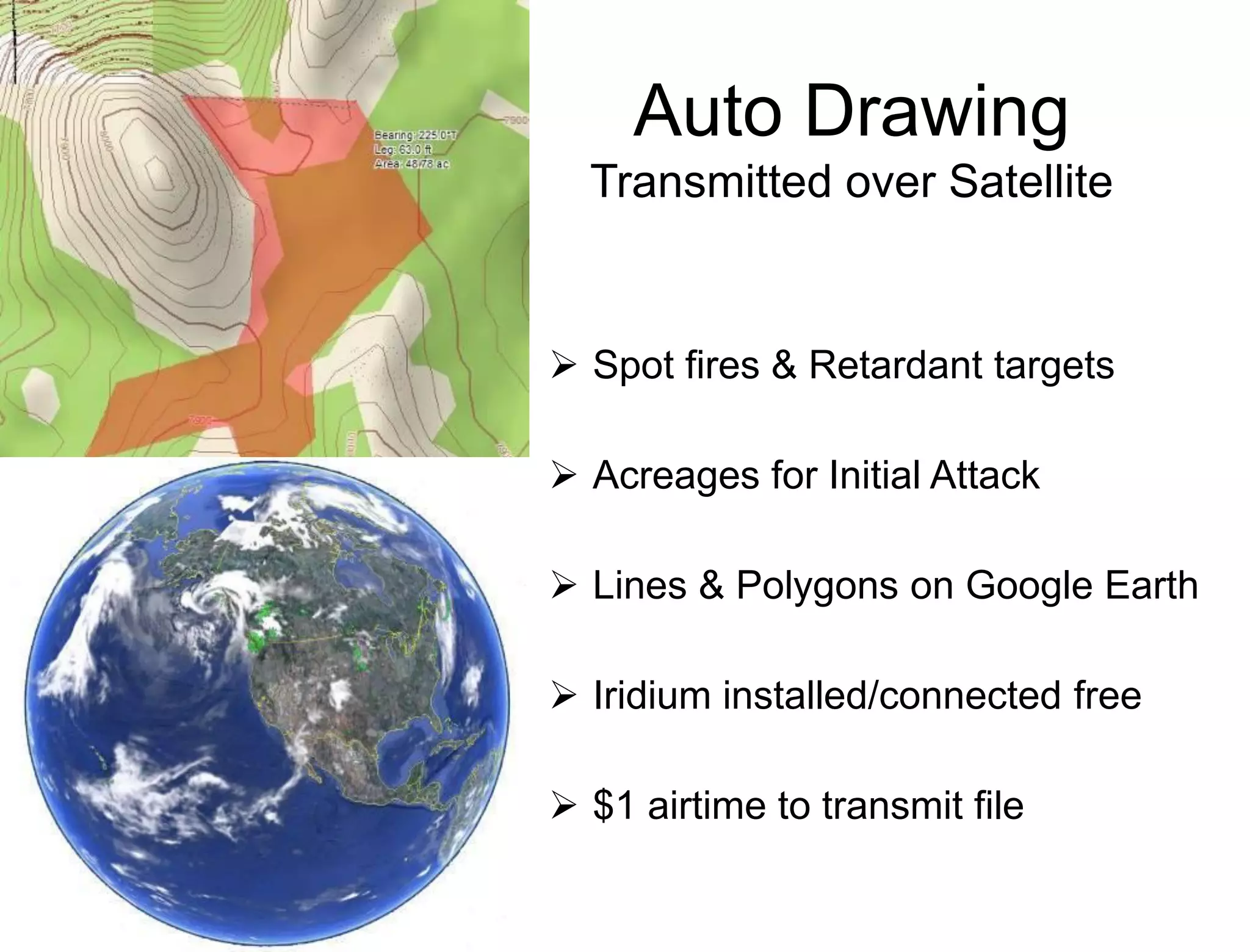
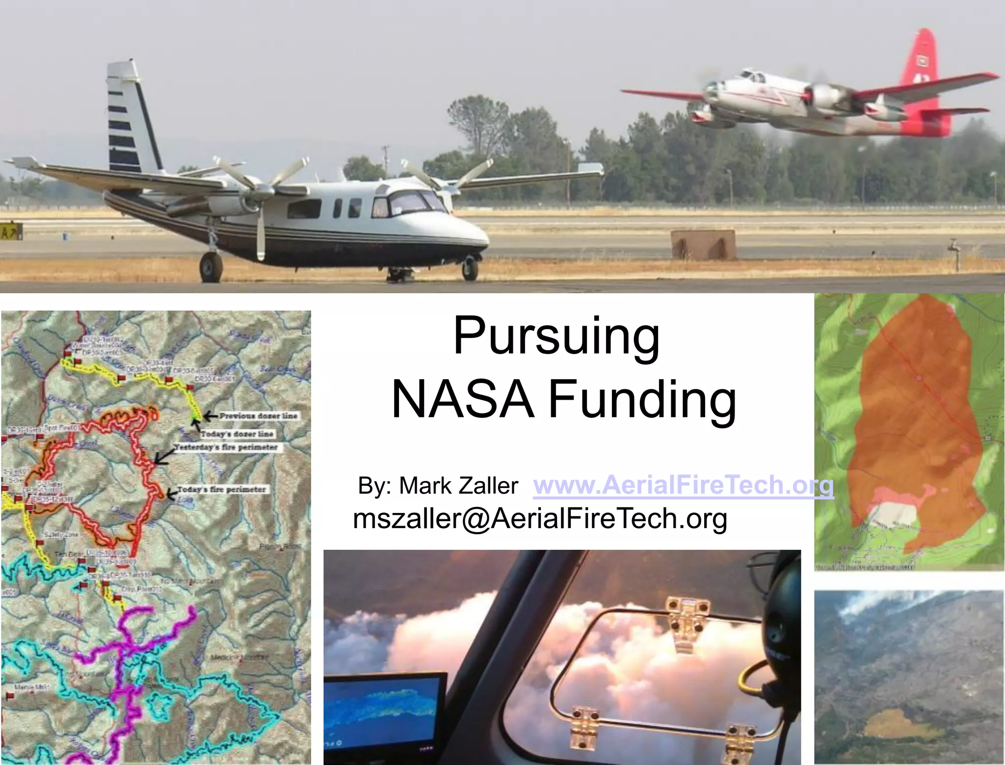
Auto-map fire changes
                            for Air Attacks
 InfraRed
    +
Auto-Polygons
    +
Ortho-rectify
                Automatic Morph


    +
Fire Mapping
                                                                          Auto-Transmit
    +                                                                       over AFF
  Mosaic
    +
2D/3D SynViz
    +
Moving-GIS
    +
   GPS

  Maps, Displays & Transmits automatically while Air Attacks fly normal tactical mission
IR Mapped from nightly          Project Goals
overflight
Air Attack updates at noon   •Infrared+new_Fire_polygons+GIS 3D
                             visualization realtime in cockpit
                             •IR camera automatically creates low quality
                             polygons of fire changes
                             •IR and/or Polygons are Geo-orthrectified and
                             displayed with moving-map GIS
                             •Polygons are updated and refined throughout
                             the day during normal Air Attack missions
                             •Polygons are transmitted over AFF (Iridium)

                             •Fire GIS is bi-directionally updated over Iridium
                             automatically
                             •Air Attack &Ground teams can draw targets
                             •Hi resolution maps are available after landing

                             •Public Domain/OpenSource software for
                             adaption & broad re-use internationally
Physical Layout
                       Display
                   Display:
                   Tablet, Pad                                      Cockpit                                 Base
                   or
                   SmartPhone
Tablet, Pad or SmartPhone


                               Battery
                                                  WiFi
                                                                                                       Headquarters
                                UPS

                              Powerful small form-factor PC
                              -Create fire update polygons
                                                                    Backseat or
             Digitize Video


                              -Ortho-rectify
              USB dongle


                              -Wifi HTML5 server
                              -Bi-directional transmit over AFF     Avionics Rack
                               Inertial       GPS
                               Module
NTSC Video


                                                         Serial


                                                            AFF
                                                          Iridium

                                                                    Built into         Fire Camp
                                                                    Plane
                                                                                    Incident Command
Battery
                                                                          UPS               WiFi

Development Tasks                                                       Powerful small form-factor PC
                                                                        -Create fire update polygons


                                                       Digitize Video
                                                                        -Ortho-rectify


                                                        USB dongle
                                                                        -Wifi HTML5 server
                                                                        -Bi-directional transmit over AFF

                                                                         Inertial       GPS
                                                                         Module


Description                              Processing                       Software Dev
•Moving map GIS                          Moderate                         Maybe Easy or Difficult
•GIS update over Iridium                 Low                              Moderate
•Digitize IR Video                       Not intense                      Very easy
•Create mosaic (optional/post)           ??? Intense                      Difficult
•Geo-Orthorectify                        Intense                          Very difficult
•Image process IR signature              Moderate                         Difficult
                                 Loop


•Reduce to polygon                       Moderate                         Moderate
•Compare Polygon to GIS                  Moderate                         Moderate
•ID change, regularly update             Moderate                         Difficult
•WiFi to cockpit Display                 Low                              Easy
•Email over Iridium                      Low                              Moderate
                                        Continuous parallel task
                                        Sequential task
Mass market IR+GIS for tactical AirOps, continuous mapping & transmission
 Hands free operation on all public safety, monitoring & research aircraft/UAVs


Significance of Innovation
• Airborne IR+GIS inexpensive as Altimeter-as easy to install & use
•No operational training or dedicated operator
•Hands-free rich 2D/3D cockpit visualization (interaction optional)
•View on wireless SmartPhones, SmartPad & Laptop/Tablet/PC
•Tactical use & automated mapping for all aircraft & UAVs
•Allows air ops at night & over smoke
•Continuous IR perimeter & signature mapping at low altitude
•Automated change analysis, highlighting & transmission to Earth


Technical Objectives & Work Plan                                      Non-Wildfire applications
1. GIS updates near real time bi-directional with ground              •Floods tactical management & mapping
2. Automatically process continuously while airborne:                 •Environmental Monitoring & mapping
       1. Mosaic continuous oblique IR video into one large image     •Volcanic, Earthquake, Tsunami tactical management & mapping
       2. Register IR imagery and polygons to Lat-Long                •Vegetation& Forest observation & mapping
       3. IR signature/threshold image processing                     •Wildlife observation & mapping
       4. Process signatures into Polygons                            •Mudslide/landslide tactical management & mapping
       5. Change detection & analysis from existing IR GIS            •Volcanic tactical management & mapping
       6. Transmits low bandwidth polygons of current changes         •Oil and Pollution spills tactical management & mapping
3. Transmit processed data on Iridium Satellite (AFF)
4. Simple yet detailed 2d/3D Moving-map HTML5 to displays
5. Choosable GIS layers & functionality for those who want
6. Works with existing Air Attack aircraft IR Microbolometer
7. Extensible so others can add software & hardware
Incident Command         Difficulties on                          Headquarters
                         Project Fires
Fire Camp

                                    Air Attack
                                    Not doing mapping
                                    Doesn’t always get paper maps
                   FM Voice         Often can’t see ground due to smoke
                   No Data


                                    Smoke


                                                                          Tanker
                                                                            Base


                              Heli-base
                                                                      Dispatch
                                              DARK
Incident Command
                      IR+GIS+AutoMapping                              Headquarters

 Fire Camp

                                      Air Attack
                                      AutoMap Spotfires & Fire Changes
                                      IR+GIS Moving-Map Situational Awareness
                     FM Voice         Near real-time transmission of fire polygons
                     Satellite Data


               IR see through Smoke & Dark - Improves Safety


                                                                             Tanker
                                                                               Base


                               Heli-base
                                                                          Dispatch
Subliminal – IR just another Window


    IR+GIS: Intuitive 1st time, Subliminal 2nd time
    Delivering a new reality to those focused on intense tasks
    Work when previously not possible: night & over smoke
    Human Factors: Being too easy could lead people into trouble
3D/2D GIS Moving-map
  90 missions in 2010, $2mil results

                       GIS: Geographic Information System

                       Initial Attack fires & Project Fires
                              95%                       5%
                       Fire History, PowerLines, DPA

                       Roads, Creeks & local names

                       Daily: Fire lines, hot spots, burn out,
                         dozer & hand lines, division breaks,
                         drop points, dip sites, etc.

                       DeLorme Xmap: Moving-map Topos
Click Here to see on YouTube
InfraRed
 Fixed mount or Gimbal
 Oriented to the Air Attack’s view
 System Integration & certification
 Very effective with smoke/night
 Hot Rocks Color
IR+GIS Augmented Reality Provides:
Instant situational awareness – Eyes spend more time outside
Overall improved efficiency. Continued operations over smoke & at night
Fresh details always: Fire lines - Road names - Place search - Routing, etc.
Safety: Terrain & hazards recognition. Ground teams visible through smoke
Auto Drawing
  Transmitted over Satellite


 Spot fires & Retardant targets

 Acreages for Initial Attack

 Lines & Polygons on Google Earth

 Iridium installed/connected free

 $1 airtime to transmit file
Pursuing
  NASA Funding
By: Mark Zaller www.AerialFireTech.org
mszaller@AerialFireTech.org

Wildfire IR and Mapping

  • 1.
    Auto-map fire changes for Air Attacks InfraRed + Auto-Polygons + Ortho-rectify Automatic Morph + Fire Mapping Auto-Transmit + over AFF Mosaic + 2D/3D SynViz + Moving-GIS + GPS Maps, Displays & Transmits automatically while Air Attacks fly normal tactical mission
  • 2.
    IR Mapped fromnightly Project Goals overflight Air Attack updates at noon •Infrared+new_Fire_polygons+GIS 3D visualization realtime in cockpit •IR camera automatically creates low quality polygons of fire changes •IR and/or Polygons are Geo-orthrectified and displayed with moving-map GIS •Polygons are updated and refined throughout the day during normal Air Attack missions •Polygons are transmitted over AFF (Iridium) •Fire GIS is bi-directionally updated over Iridium automatically •Air Attack &Ground teams can draw targets •Hi resolution maps are available after landing •Public Domain/OpenSource software for adaption & broad re-use internationally
  • 3.
    Physical Layout Display Display: Tablet, Pad Cockpit Base or SmartPhone Tablet, Pad or SmartPhone Battery WiFi Headquarters UPS Powerful small form-factor PC -Create fire update polygons Backseat or Digitize Video -Ortho-rectify USB dongle -Wifi HTML5 server -Bi-directional transmit over AFF Avionics Rack Inertial GPS Module NTSC Video Serial AFF Iridium Built into Fire Camp Plane Incident Command
  • 4.
    Battery UPS WiFi Development Tasks Powerful small form-factor PC -Create fire update polygons Digitize Video -Ortho-rectify USB dongle -Wifi HTML5 server -Bi-directional transmit over AFF Inertial GPS Module Description Processing Software Dev •Moving map GIS Moderate Maybe Easy or Difficult •GIS update over Iridium Low Moderate •Digitize IR Video Not intense Very easy •Create mosaic (optional/post) ??? Intense Difficult •Geo-Orthorectify Intense Very difficult •Image process IR signature Moderate Difficult Loop •Reduce to polygon Moderate Moderate •Compare Polygon to GIS Moderate Moderate •ID change, regularly update Moderate Difficult •WiFi to cockpit Display Low Easy •Email over Iridium Low Moderate Continuous parallel task Sequential task
  • 5.
    Mass market IR+GISfor tactical AirOps, continuous mapping & transmission Hands free operation on all public safety, monitoring & research aircraft/UAVs Significance of Innovation • Airborne IR+GIS inexpensive as Altimeter-as easy to install & use •No operational training or dedicated operator •Hands-free rich 2D/3D cockpit visualization (interaction optional) •View on wireless SmartPhones, SmartPad & Laptop/Tablet/PC •Tactical use & automated mapping for all aircraft & UAVs •Allows air ops at night & over smoke •Continuous IR perimeter & signature mapping at low altitude •Automated change analysis, highlighting & transmission to Earth Technical Objectives & Work Plan Non-Wildfire applications 1. GIS updates near real time bi-directional with ground •Floods tactical management & mapping 2. Automatically process continuously while airborne: •Environmental Monitoring & mapping 1. Mosaic continuous oblique IR video into one large image •Volcanic, Earthquake, Tsunami tactical management & mapping 2. Register IR imagery and polygons to Lat-Long •Vegetation& Forest observation & mapping 3. IR signature/threshold image processing •Wildlife observation & mapping 4. Process signatures into Polygons •Mudslide/landslide tactical management & mapping 5. Change detection & analysis from existing IR GIS •Volcanic tactical management & mapping 6. Transmits low bandwidth polygons of current changes •Oil and Pollution spills tactical management & mapping 3. Transmit processed data on Iridium Satellite (AFF) 4. Simple yet detailed 2d/3D Moving-map HTML5 to displays 5. Choosable GIS layers & functionality for those who want 6. Works with existing Air Attack aircraft IR Microbolometer 7. Extensible so others can add software & hardware
  • 6.
    Incident Command Difficulties on Headquarters Project Fires Fire Camp Air Attack Not doing mapping Doesn’t always get paper maps FM Voice Often can’t see ground due to smoke No Data Smoke Tanker Base Heli-base Dispatch DARK
  • 7.
    Incident Command IR+GIS+AutoMapping Headquarters Fire Camp Air Attack AutoMap Spotfires & Fire Changes IR+GIS Moving-Map Situational Awareness FM Voice Near real-time transmission of fire polygons Satellite Data IR see through Smoke & Dark - Improves Safety Tanker Base Heli-base Dispatch
  • 8.
    Subliminal – IRjust another Window  IR+GIS: Intuitive 1st time, Subliminal 2nd time  Delivering a new reality to those focused on intense tasks  Work when previously not possible: night & over smoke  Human Factors: Being too easy could lead people into trouble
  • 9.
    3D/2D GIS Moving-map 90 missions in 2010, $2mil results  GIS: Geographic Information System  Initial Attack fires & Project Fires 95% 5%  Fire History, PowerLines, DPA  Roads, Creeks & local names  Daily: Fire lines, hot spots, burn out, dozer & hand lines, division breaks, drop points, dip sites, etc.  DeLorme Xmap: Moving-map Topos
  • 10.
    Click Here tosee on YouTube
  • 11.
    InfraRed  Fixed mountor Gimbal  Oriented to the Air Attack’s view  System Integration & certification  Very effective with smoke/night  Hot Rocks Color
  • 13.
    IR+GIS Augmented RealityProvides: Instant situational awareness – Eyes spend more time outside Overall improved efficiency. Continued operations over smoke & at night Fresh details always: Fire lines - Road names - Place search - Routing, etc. Safety: Terrain & hazards recognition. Ground teams visible through smoke
  • 14.
    Auto Drawing Transmitted over Satellite  Spot fires & Retardant targets  Acreages for Initial Attack  Lines & Polygons on Google Earth  Iridium installed/connected free  $1 airtime to transmit file
  • 15.
    Pursuing NASAFunding By: Mark Zaller www.AerialFireTech.org mszaller@AerialFireTech.org