Geography is the study of the Earth's surface and how people interact with their environment. The document outlines key geographic concepts like regions, latitude and longitude, climate zones, culture regions, population density, land use, and how building materials and barriers reflect a region's personality. People are grouped according to similar environments, climates influence life, and land is used for housing, agriculture, resources, and urban development.
This presentation covers physical features for geography. It explains the physical characteristics of the geographic regions of North America. It covers Virginia SOL USI.2b
CAPE UNIT 1 (ONE) GEOGRAPHY- POPULATION NOTES/SLIDESOral Johnson
This is the population aspect of the CAPE geography unit one syllabus. Its not the entire notes in an expansive format but i think it sums it up nicely. The topics are:
Population distribution
Population change- natural
Population change-migration
Population Structure
Population and Resources
CSEC Human Geography- Population , Urbanization and MigrationOral Johnson
This document entails the first half of the human geography syllabus for CSEC ( excluding economic activities. It looks at population, urbanization and Migration
CSEC Human Geography- Population , Urbanization and MigrationOral Johnson
This document entails the first half of the human geography syllabus for CSEC ( excluding economic activities. It looks at population, urbanization and Migration
Ethnobotany and Ethnopharmacology:
Ethnobotany in herbal drug evaluation,
Impact of Ethnobotany in traditional medicine,
New development in herbals,
Bio-prospecting tools for drug discovery,
Role of Ethnopharmacology in drug evaluation,
Reverse Pharmacology.
Welcome to TechSoup New Member Orientation and Q&A (May 2024).pdfTechSoup
In this webinar you will learn how your organization can access TechSoup's wide variety of product discount and donation programs. From hardware to software, we'll give you a tour of the tools available to help your nonprofit with productivity, collaboration, financial management, donor tracking, security, and more.
2024.06.01 Introducing a competency framework for languag learning materials ...Sandy Millin
http://sandymillin.wordpress.com/iateflwebinar2024
Published classroom materials form the basis of syllabuses, drive teacher professional development, and have a potentially huge influence on learners, teachers and education systems. All teachers also create their own materials, whether a few sentences on a blackboard, a highly-structured fully-realised online course, or anything in between. Despite this, the knowledge and skills needed to create effective language learning materials are rarely part of teacher training, and are mostly learnt by trial and error.
Knowledge and skills frameworks, generally called competency frameworks, for ELT teachers, trainers and managers have existed for a few years now. However, until I created one for my MA dissertation, there wasn’t one drawing together what we need to know and do to be able to effectively produce language learning materials.
This webinar will introduce you to my framework, highlighting the key competencies I identified from my research. It will also show how anybody involved in language teaching (any language, not just English!), teacher training, managing schools or developing language learning materials can benefit from using the framework.
The Roman Empire A Historical Colossus.pdfkaushalkr1407
The Roman Empire, a vast and enduring power, stands as one of history's most remarkable civilizations, leaving an indelible imprint on the world. It emerged from the Roman Republic, transitioning into an imperial powerhouse under the leadership of Augustus Caesar in 27 BCE. This transformation marked the beginning of an era defined by unprecedented territorial expansion, architectural marvels, and profound cultural influence.
The empire's roots lie in the city of Rome, founded, according to legend, by Romulus in 753 BCE. Over centuries, Rome evolved from a small settlement to a formidable republic, characterized by a complex political system with elected officials and checks on power. However, internal strife, class conflicts, and military ambitions paved the way for the end of the Republic. Julius Caesar’s dictatorship and subsequent assassination in 44 BCE created a power vacuum, leading to a civil war. Octavian, later Augustus, emerged victorious, heralding the Roman Empire’s birth.
Under Augustus, the empire experienced the Pax Romana, a 200-year period of relative peace and stability. Augustus reformed the military, established efficient administrative systems, and initiated grand construction projects. The empire's borders expanded, encompassing territories from Britain to Egypt and from Spain to the Euphrates. Roman legions, renowned for their discipline and engineering prowess, secured and maintained these vast territories, building roads, fortifications, and cities that facilitated control and integration.
The Roman Empire’s society was hierarchical, with a rigid class system. At the top were the patricians, wealthy elites who held significant political power. Below them were the plebeians, free citizens with limited political influence, and the vast numbers of slaves who formed the backbone of the economy. The family unit was central, governed by the paterfamilias, the male head who held absolute authority.
Culturally, the Romans were eclectic, absorbing and adapting elements from the civilizations they encountered, particularly the Greeks. Roman art, literature, and philosophy reflected this synthesis, creating a rich cultural tapestry. Latin, the Roman language, became the lingua franca of the Western world, influencing numerous modern languages.
Roman architecture and engineering achievements were monumental. They perfected the arch, vault, and dome, constructing enduring structures like the Colosseum, Pantheon, and aqueducts. These engineering marvels not only showcased Roman ingenuity but also served practical purposes, from public entertainment to water supply.
The Indian economy is classified into different sectors to simplify the analysis and understanding of economic activities. For Class 10, it's essential to grasp the sectors of the Indian economy, understand their characteristics, and recognize their importance. This guide will provide detailed notes on the Sectors of the Indian Economy Class 10, using specific long-tail keywords to enhance comprehension.
For more information, visit-www.vavaclasses.com
Students, digital devices and success - Andreas Schleicher - 27 May 2024..pptxEduSkills OECD
Andreas Schleicher presents at the OECD webinar ‘Digital devices in schools: detrimental distraction or secret to success?’ on 27 May 2024. The presentation was based on findings from PISA 2022 results and the webinar helped launch the PISA in Focus ‘Managing screen time: How to protect and equip students against distraction’ https://www.oecd-ilibrary.org/education/managing-screen-time_7c225af4-en and the OECD Education Policy Perspective ‘Students, digital devices and success’ can be found here - https://oe.cd/il/5yV
Synthetic Fiber Construction in lab .pptxPavel ( NSTU)
Synthetic fiber production is a fascinating and complex field that blends chemistry, engineering, and environmental science. By understanding these aspects, students can gain a comprehensive view of synthetic fiber production, its impact on society and the environment, and the potential for future innovations. Synthetic fibers play a crucial role in modern society, impacting various aspects of daily life, industry, and the environment. ynthetic fibers are integral to modern life, offering a range of benefits from cost-effectiveness and versatility to innovative applications and performance characteristics. While they pose environmental challenges, ongoing research and development aim to create more sustainable and eco-friendly alternatives. Understanding the importance of synthetic fibers helps in appreciating their role in the economy, industry, and daily life, while also emphasizing the need for sustainable practices and innovation.
CLASS 11 CBSE B.St Project AIDS TO TRADE - INSURANCE
What is geography
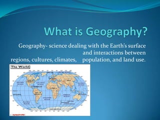
1. What is Geography? Geography- science dealing with the Earth’s surface and interactions between regions, cultures, climates, population, and land use.
6. Earth is home to 5 billion people Geography groups people according to the environment they live in. Regions- parts of the world that have the same characteristics.
7. Latitude & Longitude Coordinates used to tell where a place is located Latitude - horizontal Longitude- vertical Bovee UC 43◦ N, 84◦ W
8. Temperature Regions Regions are divided into temperatures regions because the Sun dose not heat the Earth equally. Polar regions Between 60◦N/North Pole and 60◦S/South Pole Cold weather year round Temperate regions Between 30◦ N/60◦ N and 30◦ S/60◦ S Summers- warm/hot Winters- cool/cold Tropical regions Between 30◦ N and 30◦ S Warm year round
9. Culture Regions People who live in a region with similar cultures. Language, religion, and traditions may be same Can spread across boundaries of countries, nations, and continents example) Hispanic Culture
10. Population Cartogram- The size show how big the country’s population is. Population Density- the number of people living in an area.
12. Physical Features and Climate Physical Features create both opportunities and difficulties for people Physical Features: rivers, valleys, mountains, plains, and plateaus Climate affects all aspects of life like your home, job, food, clothes, and where you live. There are 4 different Climates: Tropical, Temperate, Polar, and Dry.
13. Climate Tropical Temperate Warm-hot year round Lots of rainfall Dense forests Erosion problems Asia, Africa, and South America Cool-Cold Winters Warm-Hot Summers Summers long enough to grow crops Precipitation varies
14. Climate Polar Dry Very cold and dry Snow and ice covered People who live in Polar climates adapted to the weather. Fish/hunt for food Wear protective clothes Found at many latitudes Deserts in Africa & Middle East. Cooler temperatures in U.S. and Asia. Vegetation: grass, shrubs, or cactuses To grow crops farmers need to bring water in (irrigation system).
24. Cities and Suburbs Cities- a town with a large population. Has apartment, commercial, government building Can have many different culture in on area: Chinatown and Greektown in Chicago Suburbs- The outskirts of a city where residential homes are.
25. Building Materials Northern Europe- wood house Hot dry climate- mud or clay Wet tropical regions- walls made from wood, roofs made from leaves Other common materials: stone, brick, straw, and ice You can tell a lot about a region by what the house is made out of.
26. Barriers Mountain Ocean Today there are still people who live up in the mountains and are cut off from civilization. They live off the mountain in small communities. Before there was navigation systems people would use the ocean currents to cross the ocean. Andes Mountains
28. References The world map http://www.georgehernandez.com/h/xMartialArts/Geography.asp Geography definition http://dictionary.reference.com/browse/geography Picture of world population http://home.comcast.net/~DiazStudents/whistory_units1.htm Picture of world regions http://home.comcast.net/~DiazStudents/whistory_units1.htm Picture of Bovee http://itouchmap.com/latlong.html Picture of Hispanic culture http://en.wikipedia.org/wiki/File:Hispanic_Culture-World_Map.png World cartogram picture from The World And Its People book Climate map http://mappery.com/map-of/World-Climate-Map Physical features picture form Microsoft Clip Art Climate pictures from Microsoft Clip Art How do people use the land picture http://www.waterencyclopedia.com/La-Mi/Land-Use-Planning .html Land Uses pictures from Microsoft Clip Art
29. References Picture of Chinatown http://www.chicagochinatown.org/cccorg/article.jsp?pageReq=p1214322194157& articleID=a1214545920334 Picture of Greektown http://www.google.com/imgres?q=greektown+chicago&um=1&hl=en&safe=off&r lz=1C1CHFX_ enUS391US391&biw=1440&bih=775&tbm=isch&tbnid=6zCKW-wgc_P_uM:&imgrefurl=http:// m.wikitravel.org/en /Chicago/Near_ West_ Side&docid=6vUP6TdihQxWcM&w=2048&h=1365& ei=ECeTTrTKOtKDsgKXtP29 AQ&zoom=1&iact=rc&dur=315& page=1&tbnh=122&tbnw= 176&start=0&ndsp=30&ved=1t:429,r:25,s:0&tx=99&ty=49 Picture of suburbs http://citiesetc.blogspot.com/2011/03/suburbs.html Picture of wood house http://www.superstock.co.uk/stock-photos-images/1848-269027 Picture of mud house http://blog.travelpod.com/travel-blog-entries/beebowen/1/1272287231/tpod.html#_ Picture of rainforest hut http://www.travelsinparadise.com/travelarticle/ecuador-rainforest.html Picture of Andes Mountains http://www.google.com/imgres?q=villages+in+the+andes&um=1&hl=en&safe=off&rlz=1C1CHFX_enUS391US391&biw=1440&bih=775&tbm=isch&tbnid=pefLp6bUYPKpZM:&imgrefurl=http://www.aynishamanichealing.eu/pictures.php&docid=Si8N5G7iGTgxEM&w=600&h=450&ei=c0mTTuG2M-iNsAKPgd2bAQ&zoom=1&iact=rc&dur=299&page=4&tbnh=125&tbnw=176&start=86&ndsp=29&ved=1t:429,r:24,s:86&tx=108&ty=90 Picture of ocean currents http://destinationofmarvel.blogspot.com/2011/01/ocean-currents-and-salinity.html Information from Garcia, Juan R., Daniel J. Gelo, Linda L. Greennow, James B. Kracht, Deborah Gray White, and Becky Manfredini. The World And Its People. Sliver Burdett Ginn, 1997. Print.
![Outline ,[object Object]](data:image/gif;base64,R0lGODlhAQABAIAAAAAAAP///yH5BAEAAAAALAAAAAABAAEAAAIBRAA7)