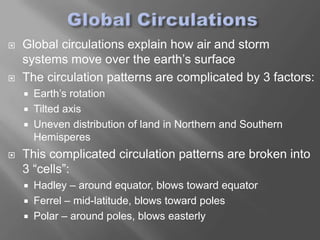
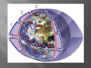
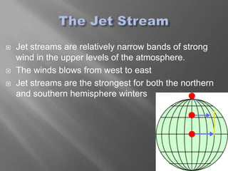
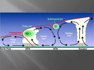
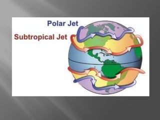
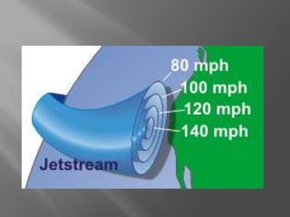
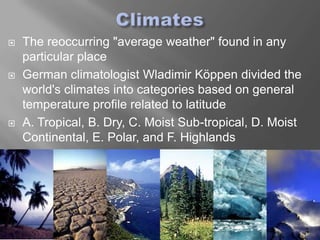
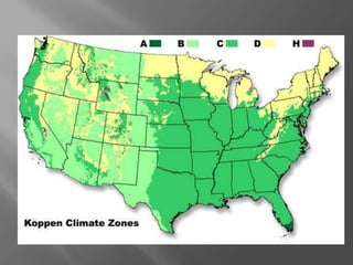
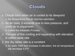
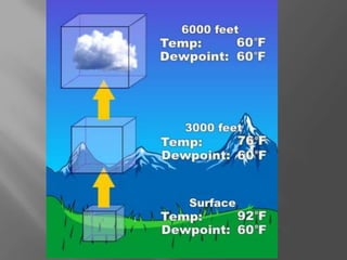
   Global circulations explain how air and storm
    systems move over the earth’s surface
   The circulation patterns are complicated by 3 factors:
       Earth’s rotation
       Tilted axis
       Uneven distribution of land in Northern and Southern
        Hemisperes
   This complicated circulation patterns are broken into
    3 “cells”:
       Hadley – around equator, blows toward equator
       Ferrel – mid-latitude, blows toward poles
       Polar – around poles, blows easterly
   Jet streams are relatively narrow bands of strong
    wind in the upper levels of the atmosphere.
   The winds blows from west to east
   Jet streams are the strongest for both the northern
    and southern hemisphere winters
   The Jet stream follows the sun’s angle in the
    sky, southerly in the summer and northerly in the
    winter.
   Jet streams are typically wide and not distinct, but
    a region where the wind increase toward a core
    of strongest wind.
   One way of visualizing this is consider a river.
       The river's current is generally the strongest in the
        center with decreasing strength as one approaches the
        river's bank. It can be said that jet streams are "rivers
        of air.“
   The reoccurring "average weather" found in any
    particular place
   German climatologist Wladimir Köppen divided the
    world's climates into categories based on general
    temperature profile related to latitude
   A. Tropical, B. Dry, C. Moist Sub-tropical, D. Moist
    Continental, E. Polar, and F. Highlands
   Heat waves kill more people in the United States
    than all of the other weather related
    disasters combined
   Humans perspire to cool themselves, therefore the
    higher the humidity, the harder it is for humans to
    cool themselves
   Heat index is a function of humidity and temperature
   Remember, these values are in the SHADE
   You can add up to 15°F (8°C) to these values if you
    are in direct sunlight
   The effect of the wind on people and animals
   As the wind increases, it removes heat from
    the body, driving down skin temperature
   inanimate objects will not cool below the actual
    air temperature
Temperature (°F)
 W
  i
  n
  d    40 35 30 25 20 15 10 5       0 -5 -10 -15 -20 -25 -30 -35 -40 -45 -50 -55 -60
(mph
  )

 0     40 35 30 25 20 15 10     5   0   -5 -10 -15 -20 -25 -30 -35 -40 -45 -50 -55 -60
 5     37 31 25 19 13   7   1   -5 -11 -16 -22 -28 -34 -40 -46 -52 -58 -63 -69 -75 -81
10 34 27 21 15 11       3   -4 -10 -16 -22 -28 -35 -41 -47 -53 -59 -66 -72 -78 -84 -90
15 32 25 19 13      6   0   -7 -13 -19 -26 -32 -39 -45 -51 -58 -64 -71 -77 -83 -90 -96
                                                                                      -
20 30 24 17 11      4   -2 -9 -15 -22 -29 -35 -42 -48 -55 -61 -68 -74 -81 -88 -94
                                                                                     101
                                                                                      -
25 29 23 16     9   3   -4 -11 -17 -24 -31 -38 -44 -51 -58 -64 -71 -78   -84 -91 -98
                                                                                     104
                                                                                  -   -
30 28 22 15     8   1   -6 -12 -19 -26 -33 -39 -46 -53 -60 -67 -73 -80   -87 -94
                                                                                 101 107
                                                                                  -   -
35 28 21 14     7   0   -7 -14 -21 -27 -34 -41 -48 -55 -62 -69 -76 -83   -89 -96
                                                                                 103 110
                                                                                  -   -
40 27 20 13     6   -1 -8 -15 -22 -29 -36 -43 -50 -57 -64 -71 -78 -84    -91 -98
                                                                                 105 112
                                                                              -   -   -
45 26 19 12     5   -2 -9 -16 -23 -30 -37 -44 -51 -58 -65 -72 -79 -86    -93
                                                                             100 107 114
                                                                              -   -   -
50 26 19 12     4   -3 -10 -17 -24 -31 -38 -45 -52 -60 -67 -74 -81 -88   -95
                                                                             102 109 116
   All aspects of meteorology are based upon a
    world-wide 24-hour clock called Zulu time
   more commonly called Universal Time
    Coordinate
   With the 360° daily rotation of the earth, the sun
    is moving 15° each hour which leads to the
    formation of 24 time zones
   Based on the time in Greenwich, England.
   00Z (midnight zulu) is 6 pm Central Standard
   Clouds form when air is cooled to its dewpoint
       the temperature the air reaches saturation
   As air rises, it expands due to less pressure, and
    cools do to expansion
       Called the Adiabatic Process
   The rate of this cooling and expanding with elevation
    is called lapse rate
   the dry lapse rate is a constant
       for each 1000 feet increase in elevation, the air temperature
        will decrease 5.4°F
   Cirro form – high level clouds composed mostly of
    ice crystals, denote fair weather
   Nimbo form – mid-level clouds that are very heavy
    with moisture and bring steady rain
   Cumulo form – fluffy midlevel clouds that have a flat
    base and are very tall
   Strato form – low level clouds that form a blanket
    over the sky and bring dizzily weather
   Air in motion
   A wind vane measures the wind direction
   An anemometer measures the wind speed
   Isobars on a weather map denote areas of equal
    pressure
       The closer the isobars, the greater the pressure gradient
   Wind speed is directly proportional to pressure
    gradient
   Wind speed and direction are also impacted by the
    coriolis force – the earth’s rotation
   Winds spiral out of high pressure regions and
    into low pressure regions because of friction.
   Fronts are the boundaries between two air masses
   The front is classified by what type of air is moving
    into the region (warm/cold)
   Warm fronts typically have a gentle slope so the air
    rising along the frontal surface is gradual
       stratiform cloudiness and precipitation along and to the
        north of the front
   The slope of cold fronts are more steep and air is
    forced upward more abruptly
       narrow band of showers and thunderstorms along or just
        ahead of the front
   Needs ingredients to create
     A source of moisture
     Typically a large body of water like oceans

   Lifting of moist air must occur
       Mountains, pressure gradients, frontal boundaries
   Ice crystals or water droplets need to grow
    large enough to fall
       Collision and coalescence or ice crystal method
   Rain – liquid water droplets
   Snow – Crystallized frozen water
   Sleet – frozen water droplets
   Freezing Rain – Water droplets that freeze when
    they land on objects
   Hail – Larger balls of ice that have formed from
    repeated lifting and falling through the atmosphere
    adding layers of ice each time
   Ingredients
       Moisture, instability, uplift
   Life Cycle – lasts about 30 min
     Towering Cumulus (strong updrafts)
     Mature Cumulus (updrafts and down drafts)
     Dissipating Stage (downdrafts)
   Tornadoes come from super cells with strong
    wind sheers.
   The greatest chance for tornado comes from
    the mesocyclone area.
   Enhanced F-Scale:
       EF0 (65-85 mph) – EF5
        (over 200 mph)
   Giant spark of static electricity
   Largely a mystery to scientists
   1 billion volts, 300,000 amps, and 10 miles away
   Thunder is the acoustic shock wave resulting from
    the extreme heat generated by a lightning flash
   For every second between the flash of lightning and
    the clap of thunder, you can estimate 1 mile until the
    storm is directly over you
   Stands for RAdio Detection And Ranging
   WSR-88D
       Weather Surveillance Radar - 1988 Doppler
   Gives the ability to detect motion
   Bounces radio waves off of water droplets in
    clouds.
       The larger or denser the droplets, the stronger the
        reflected signal, and the more severe the storm.
Cloud Types

    Temperature
                                                 Pressure in
                                                 mb (999.8)


Visibility (mi)


       Current
       weather                                  Change in
                                                pressure (mb)

Wind Speed
& Direction
                                                Cloud Types

Cloud Types
                  Cloud ceiling

Weather Part 2

  • 3.
    Global circulations explain how air and storm systems move over the earth’s surface  The circulation patterns are complicated by 3 factors:  Earth’s rotation  Tilted axis  Uneven distribution of land in Northern and Southern Hemisperes  This complicated circulation patterns are broken into 3 “cells”:  Hadley – around equator, blows toward equator  Ferrel – mid-latitude, blows toward poles  Polar – around poles, blows easterly
  • 5.
    Jet streams are relatively narrow bands of strong wind in the upper levels of the atmosphere.  The winds blows from west to east  Jet streams are the strongest for both the northern and southern hemisphere winters
  • 8.
    The Jet stream follows the sun’s angle in the sky, southerly in the summer and northerly in the winter.  Jet streams are typically wide and not distinct, but a region where the wind increase toward a core of strongest wind.  One way of visualizing this is consider a river.  The river's current is generally the strongest in the center with decreasing strength as one approaches the river's bank. It can be said that jet streams are "rivers of air.“
  • 10.
    The reoccurring "average weather" found in any particular place  German climatologist Wladimir Köppen divided the world's climates into categories based on general temperature profile related to latitude  A. Tropical, B. Dry, C. Moist Sub-tropical, D. Moist Continental, E. Polar, and F. Highlands
  • 12.
    Heat waves kill more people in the United States than all of the other weather related disasters combined  Humans perspire to cool themselves, therefore the higher the humidity, the harder it is for humans to cool themselves  Heat index is a function of humidity and temperature  Remember, these values are in the SHADE  You can add up to 15°F (8°C) to these values if you are in direct sunlight
  • 14.
    The effect of the wind on people and animals  As the wind increases, it removes heat from the body, driving down skin temperature  inanimate objects will not cool below the actual air temperature
  • 15.
    Temperature (°F) W i n d 40 35 30 25 20 15 10 5 0 -5 -10 -15 -20 -25 -30 -35 -40 -45 -50 -55 -60 (mph ) 0 40 35 30 25 20 15 10 5 0 -5 -10 -15 -20 -25 -30 -35 -40 -45 -50 -55 -60 5 37 31 25 19 13 7 1 -5 -11 -16 -22 -28 -34 -40 -46 -52 -58 -63 -69 -75 -81 10 34 27 21 15 11 3 -4 -10 -16 -22 -28 -35 -41 -47 -53 -59 -66 -72 -78 -84 -90 15 32 25 19 13 6 0 -7 -13 -19 -26 -32 -39 -45 -51 -58 -64 -71 -77 -83 -90 -96 - 20 30 24 17 11 4 -2 -9 -15 -22 -29 -35 -42 -48 -55 -61 -68 -74 -81 -88 -94 101 - 25 29 23 16 9 3 -4 -11 -17 -24 -31 -38 -44 -51 -58 -64 -71 -78 -84 -91 -98 104 - - 30 28 22 15 8 1 -6 -12 -19 -26 -33 -39 -46 -53 -60 -67 -73 -80 -87 -94 101 107 - - 35 28 21 14 7 0 -7 -14 -21 -27 -34 -41 -48 -55 -62 -69 -76 -83 -89 -96 103 110 - - 40 27 20 13 6 -1 -8 -15 -22 -29 -36 -43 -50 -57 -64 -71 -78 -84 -91 -98 105 112 - - - 45 26 19 12 5 -2 -9 -16 -23 -30 -37 -44 -51 -58 -65 -72 -79 -86 -93 100 107 114 - - - 50 26 19 12 4 -3 -10 -17 -24 -31 -38 -45 -52 -60 -67 -74 -81 -88 -95 102 109 116
  • 16.
    All aspects of meteorology are based upon a world-wide 24-hour clock called Zulu time  more commonly called Universal Time Coordinate  With the 360° daily rotation of the earth, the sun is moving 15° each hour which leads to the formation of 24 time zones  Based on the time in Greenwich, England.  00Z (midnight zulu) is 6 pm Central Standard
  • 17.
    Clouds form when air is cooled to its dewpoint  the temperature the air reaches saturation  As air rises, it expands due to less pressure, and cools do to expansion  Called the Adiabatic Process  The rate of this cooling and expanding with elevation is called lapse rate  the dry lapse rate is a constant  for each 1000 feet increase in elevation, the air temperature will decrease 5.4°F
  • 19.
    Cirro form – high level clouds composed mostly of ice crystals, denote fair weather  Nimbo form – mid-level clouds that are very heavy with moisture and bring steady rain  Cumulo form – fluffy midlevel clouds that have a flat base and are very tall  Strato form – low level clouds that form a blanket over the sky and bring dizzily weather
  • 20.
    Air in motion  A wind vane measures the wind direction  An anemometer measures the wind speed  Isobars on a weather map denote areas of equal pressure  The closer the isobars, the greater the pressure gradient  Wind speed is directly proportional to pressure gradient  Wind speed and direction are also impacted by the coriolis force – the earth’s rotation
  • 22.
    Winds spiral out of high pressure regions and into low pressure regions because of friction.
  • 23.
    Fronts are the boundaries between two air masses  The front is classified by what type of air is moving into the region (warm/cold)  Warm fronts typically have a gentle slope so the air rising along the frontal surface is gradual  stratiform cloudiness and precipitation along and to the north of the front  The slope of cold fronts are more steep and air is forced upward more abruptly  narrow band of showers and thunderstorms along or just ahead of the front
  • 25.
    Needs ingredients to create  A source of moisture  Typically a large body of water like oceans  Lifting of moist air must occur  Mountains, pressure gradients, frontal boundaries  Ice crystals or water droplets need to grow large enough to fall  Collision and coalescence or ice crystal method
  • 26.
    Rain – liquid water droplets  Snow – Crystallized frozen water  Sleet – frozen water droplets  Freezing Rain – Water droplets that freeze when they land on objects  Hail – Larger balls of ice that have formed from repeated lifting and falling through the atmosphere adding layers of ice each time
  • 28.
    Ingredients  Moisture, instability, uplift  Life Cycle – lasts about 30 min  Towering Cumulus (strong updrafts)  Mature Cumulus (updrafts and down drafts)  Dissipating Stage (downdrafts)
  • 32.
    Tornadoes come from super cells with strong wind sheers.  The greatest chance for tornado comes from the mesocyclone area.  Enhanced F-Scale:  EF0 (65-85 mph) – EF5 (over 200 mph)
  • 34.
    Giant spark of static electricity  Largely a mystery to scientists  1 billion volts, 300,000 amps, and 10 miles away  Thunder is the acoustic shock wave resulting from the extreme heat generated by a lightning flash  For every second between the flash of lightning and the clap of thunder, you can estimate 1 mile until the storm is directly over you
  • 35.
    Stands for RAdio Detection And Ranging  WSR-88D  Weather Surveillance Radar - 1988 Doppler  Gives the ability to detect motion  Bounces radio waves off of water droplets in clouds.  The larger or denser the droplets, the stronger the reflected signal, and the more severe the storm.
  • 36.
    Cloud Types Temperature Pressure in mb (999.8) Visibility (mi) Current weather Change in pressure (mb) Wind Speed & Direction Cloud Types Cloud Types Cloud ceiling