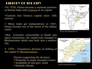
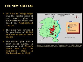
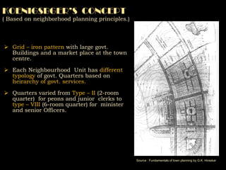
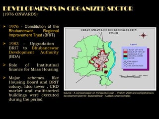
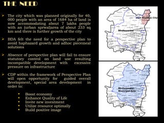
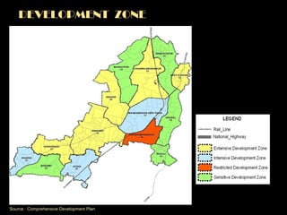
FROM     “ TEMPLE CITY”   TO   World  Class “ CAPITAL CITY”
ANCIENT  CITY The ancient city has a history that goes back more than  2000 years. The first mention of Bhubaneswar in Indian history is in the infamous  Kalinga War  which was held near  Dhauli  (presently located in south Bhubaneswar) In  3rd Century BC . Later Emperor Kharavela established his capital in  Sisupalgarh  which is on the outskirts of the city. The  Hathigumpha  at the  Udayagiri caves  and  Khandagiri caves  by Kharavela give a good account of that period which is estimated as  1st-2nd century BC . Later innumerable temples built throughout ancient and medieval history in tune with its status as Temple City give a chronicle of the city's history till Indian independence in 1947. Source: www.wikipedia.com
HISTORY OF THE CITY In  1936 , Orissa became a separate province in British India with  Cuttack  as its capital Cuttack was Orissa's capital since 12th century. When India got independence in 1947, Orissa became one of the states of the Indian union.  But  Cuttack's vulnerability to floods and space constraints, the capital was changed to Bhubaneswar which was built into a modern city.  1946  – Unanimous decision of shifting of the capital to  Bhubaneshwar. Factors supporting the decision: Proximity to major transport routes. Availabilty of vast govt. Land Suitable climate. Source: www.mapsofindia.com Source: www.mapsofindia.com
Dr. Otto H. Konigsberger  was the master mind of the master plan of Bhubaneshwar which was based on  Neighborhood concept The plan was developed for population of  40,000 and over an area of 16.48 sq. Km The master plan had a clear social agenda in accordance with  Nehru’s vision who laid the foundation stone in Bhubaneshwar in 1948. THE  NEW  CAPITAL Source : A concept paper on Perspective plan – VISION 2030 and comprehensive development plan for  Bubaneshwar – Cuttack urban complex
KOENIGSBGER’S  CONCEPT ( Based on neighborhood planning principles.) Grid – iron pattern  with large govt. Buildings and a market place at the town centre. Each Neighbourhood  Unit has  different  typology  of govt. Quarters based on  heirarchy of govt. services. Quarters varied from  Type – II  (2-room quarter)  for peons and junior  clerks to  type – VIII  (6-room quarter) for  minister and senior Officers. Source : Fundamentals of town planning by G.K. Hiraskar
GROWTH OF INSTITUTIONS  (1956 – 76) During  1956-76  -  major  administrative activities centres  like secretariat, heads of departments etc came up in Bhubaneswar  . The  climate   , availability of suitable land   & regional connectivity  attracted a number of state level and regional institution s and industrial units. Industrialization and urbanization resulted growth of population and thus the need for residential units Source : A concept paper on Perspective plan – VISION 2030 and comprehensive development plan for  Bubaneshwar – Cuttack urban complex
DEVELOPMENTS IN ORGANIZED SECTOR  (1976 ONWARDS) 1976  -  Constitution of the  Bhubaneswar Regional Improvement Trust  (BRIT)  1983  – Upgradation  BRIT to  Bhubaneswar Development Authority  (BDA) Role of Institutinal finance for Mass Housing Major schemes like Housing Board and BRIT colony, Idco tower , CRD market and multistoried buildings were executed during the period Source : A concept paper on Perspective plan – VISION 2030 and comprehensive development plan for  Bubaneshwar – Cuttack urban complex
EXISTING  LAND USE  BREAK - UP Source : Comprehensive Development Plan Existing Land Use Break –up for BMC Existing Land Use Break –up for BDPA
GROWTH  DIRECTIONS Source : Primary survey and secondary survey Source : Primary survey and secondary survey The City The Region Bhubaneswar Towards Puri Nandan Kanan Cuttack Jatni Bhubaneswar Jatni Khurda Chandaka Chowdwar
POTENTIAL FOR GROWTH -  Regional Connectivity    Source : Dept. of Architecture and Regional Planning, IIT Kharagpur Jajpur Konarka Puri Paradwip Port Nayagarh Ganjam Dhenkanal Jagatsinghapur Cuttack Kendraparha Bhubaneswar BCUC Choudwar To Kolkata To Chennai Jatni Khurda
POTENTIAL FOR  DEVELOPMENT –  The  Resources   Source : Dept. of Architecture and Regional Planning, IIT Kharagpur Jajpur BCUC Konark Tourist Based Activities Puri Paradwip Port Port Based Activities Seafood Resources Rich Agricultural Produce Nayagarh Ganjam Kalinga Industrial Complex Dhenkanal Rich Mineral Resources Rich Forest Resources
THE  NEED The city which was planned originally for 40, 000 people with an area of 1684 ha of land is now accommodating about 7 lakhs people with an (urban sprwal)area of about 233 sq km  and there is further growth of the city BDA felt the need for a perspective plan to avoid haphazard growth and adhoc piecemeal solutions Absence of perspective plan will fail to ensure statutory control on land use resulting incompatible development with  excessive pressure on infrastructure CDP within the framework of Perspective Plan will open opportunity for  guided overall development, special area development  in order to: Boost economy Enhance Quality of Life Invite new investment Utilize resource optimally Build positive image East Kuakhai City Bhubaneswar Bhubaneswar Municipal Area
COMPREHENSIVE  DEVELOPMENT  PLAN The Bhubaneswar Development plan  is prepared by Planning Dept, IIT Kharagpur  with a long term vision It is prepared for a projected population of  30 lakhs in 2030  and for a  area of 419.10 sq km To satisfy the long term vision, the plan pays emphasis on following aspects: Effective connectivity  Creating developable land Economic activities on functional features New location of Airport Revitalization of High-Tech Corridor (Khurda, Jatni ) Special Housing Zones Conservation of Heritage & Culture Development of Slums
BHUBANESWAR  DEVELOPMENT  PLAN  AREA Source : Comprehensive Development Plan Category No. of villages Area (in Sq.km) Bhubaneswar Municipal Corporation 60 146.60 Khurda Municipalty 10 29.73 Jatni Municipalty 13 25.74 BDPA Rural 122 217.19 Total   205 419.26
THE  STRUCTURE  OF  CDP Existing characteristics and potentials of region Settlement Systems Demography Economic Base and Employment  Resource and Environmental Sustainability  Physical and Social Infrastructure  Housing and Slums Identification of policy issues through Participatory Approach Projected requirements and assessment of  deficiencies Evaluation of alternative set of Development Strategies Future  Growth  Direction Investment Programmes and Priorities  Development Management and Capacity Building THE  STRUCTURE  OF  CDP IS BASED ON
Translation of broad level strategies into implementable  medium term planning proposals Further necessary details and intended actions in form of strategies and physical proposals for various policies given  in  the  Perspective Plan  Elaboration on  Identification of the thrust areas Phasing of development Implementation strategies Resource mobilization  Prioritization of the development initiatives Generating awareness on benefits of development  THE  STRUCTURE  OF  CDP
Based on multi criteria analysis, BDPA is divided into four broad categories Extensive Development Zone Intensive Development Zone Sensitive Development Zone Restrictive Development Zone On the basis of four broad categories, the BDPA area is divided into 14 Planning zones for facilitating  smooth implementation of plan proposals. THE  ACTION  PLAN
THE  ACTION  PLAN The Plan emphasizes  : Effective connectivity  Creating developable land by gainfully utilizing the huge land resource of around 25000 acres of build able government land. Economic activities on functional features Expansion of the existing Airport and/or New location of Airport Revitalization of Khurda, Jatni High-Tech Corridor Special Housing Zones Conservation of Heritage & Culture Development of Slums Projected population by 2030 : 30 lakhs Knowledge based service sector given prime importance Bhubaneswar will act as centre of Health & education services
DEVELOPMENT  ZONE Source : Comprehensive Development Plan
PROJECTED  FIGURES Source : Comprehensive Development Plan
PROPOSED  LAND  USE Source : Comprehensive Development Plan
THE  VISION Through this planning the CDP aims to achieve following aspects by 2030 Total housing requirement of  4.4 lakh 100%  water supply distribution with a water requirement of  88 MGD All Physical and Social Infrastructure proposed for a development of 30 lakhs Population Holistic approach for development of culture and associated tourism Better transportation connectivity and up gradation of existing links.
With the above planning exercise i.e. VISION – 2030, this Temple City in future shall be transformed to a world Class City. Thank You

Vision 2030

  • 1.
    FROM “ TEMPLE CITY” TO World Class “ CAPITAL CITY”
  • 2.
    ANCIENT CITYThe ancient city has a history that goes back more than 2000 years. The first mention of Bhubaneswar in Indian history is in the infamous Kalinga War which was held near Dhauli (presently located in south Bhubaneswar) In 3rd Century BC . Later Emperor Kharavela established his capital in Sisupalgarh which is on the outskirts of the city. The Hathigumpha at the Udayagiri caves and Khandagiri caves by Kharavela give a good account of that period which is estimated as 1st-2nd century BC . Later innumerable temples built throughout ancient and medieval history in tune with its status as Temple City give a chronicle of the city's history till Indian independence in 1947. Source: www.wikipedia.com
  • 3.
    HISTORY OF THECITY In 1936 , Orissa became a separate province in British India with Cuttack as its capital Cuttack was Orissa's capital since 12th century. When India got independence in 1947, Orissa became one of the states of the Indian union. But Cuttack's vulnerability to floods and space constraints, the capital was changed to Bhubaneswar which was built into a modern city. 1946 – Unanimous decision of shifting of the capital to Bhubaneshwar. Factors supporting the decision: Proximity to major transport routes. Availabilty of vast govt. Land Suitable climate. Source: www.mapsofindia.com Source: www.mapsofindia.com
  • 4.
    Dr. Otto H.Konigsberger was the master mind of the master plan of Bhubaneshwar which was based on Neighborhood concept The plan was developed for population of 40,000 and over an area of 16.48 sq. Km The master plan had a clear social agenda in accordance with Nehru’s vision who laid the foundation stone in Bhubaneshwar in 1948. THE NEW CAPITAL Source : A concept paper on Perspective plan – VISION 2030 and comprehensive development plan for Bubaneshwar – Cuttack urban complex
  • 5.
    KOENIGSBGER’S CONCEPT( Based on neighborhood planning principles.) Grid – iron pattern with large govt. Buildings and a market place at the town centre. Each Neighbourhood Unit has different typology of govt. Quarters based on heirarchy of govt. services. Quarters varied from Type – II (2-room quarter) for peons and junior clerks to type – VIII (6-room quarter) for minister and senior Officers. Source : Fundamentals of town planning by G.K. Hiraskar
  • 6.
    GROWTH OF INSTITUTIONS (1956 – 76) During 1956-76 - major administrative activities centres like secretariat, heads of departments etc came up in Bhubaneswar . The climate , availability of suitable land & regional connectivity attracted a number of state level and regional institution s and industrial units. Industrialization and urbanization resulted growth of population and thus the need for residential units Source : A concept paper on Perspective plan – VISION 2030 and comprehensive development plan for Bubaneshwar – Cuttack urban complex
  • 7.
    DEVELOPMENTS IN ORGANIZEDSECTOR (1976 ONWARDS) 1976 - Constitution of the Bhubaneswar Regional Improvement Trust (BRIT) 1983 – Upgradation BRIT to Bhubaneswar Development Authority (BDA) Role of Institutinal finance for Mass Housing Major schemes like Housing Board and BRIT colony, Idco tower , CRD market and multistoried buildings were executed during the period Source : A concept paper on Perspective plan – VISION 2030 and comprehensive development plan for Bubaneshwar – Cuttack urban complex
  • 8.
    EXISTING LANDUSE BREAK - UP Source : Comprehensive Development Plan Existing Land Use Break –up for BMC Existing Land Use Break –up for BDPA
  • 9.
    GROWTH DIRECTIONSSource : Primary survey and secondary survey Source : Primary survey and secondary survey The City The Region Bhubaneswar Towards Puri Nandan Kanan Cuttack Jatni Bhubaneswar Jatni Khurda Chandaka Chowdwar
  • 10.
    POTENTIAL FOR GROWTH- Regional Connectivity Source : Dept. of Architecture and Regional Planning, IIT Kharagpur Jajpur Konarka Puri Paradwip Port Nayagarh Ganjam Dhenkanal Jagatsinghapur Cuttack Kendraparha Bhubaneswar BCUC Choudwar To Kolkata To Chennai Jatni Khurda
  • 11.
    POTENTIAL FOR DEVELOPMENT – The Resources Source : Dept. of Architecture and Regional Planning, IIT Kharagpur Jajpur BCUC Konark Tourist Based Activities Puri Paradwip Port Port Based Activities Seafood Resources Rich Agricultural Produce Nayagarh Ganjam Kalinga Industrial Complex Dhenkanal Rich Mineral Resources Rich Forest Resources
  • 12.
    THE NEEDThe city which was planned originally for 40, 000 people with an area of 1684 ha of land is now accommodating about 7 lakhs people with an (urban sprwal)area of about 233 sq km and there is further growth of the city BDA felt the need for a perspective plan to avoid haphazard growth and adhoc piecemeal solutions Absence of perspective plan will fail to ensure statutory control on land use resulting incompatible development with excessive pressure on infrastructure CDP within the framework of Perspective Plan will open opportunity for guided overall development, special area development in order to: Boost economy Enhance Quality of Life Invite new investment Utilize resource optimally Build positive image East Kuakhai City Bhubaneswar Bhubaneswar Municipal Area
  • 13.
    COMPREHENSIVE DEVELOPMENT PLAN The Bhubaneswar Development plan is prepared by Planning Dept, IIT Kharagpur with a long term vision It is prepared for a projected population of 30 lakhs in 2030 and for a area of 419.10 sq km To satisfy the long term vision, the plan pays emphasis on following aspects: Effective connectivity Creating developable land Economic activities on functional features New location of Airport Revitalization of High-Tech Corridor (Khurda, Jatni ) Special Housing Zones Conservation of Heritage & Culture Development of Slums
  • 14.
    BHUBANESWAR DEVELOPMENT PLAN AREA Source : Comprehensive Development Plan Category No. of villages Area (in Sq.km) Bhubaneswar Municipal Corporation 60 146.60 Khurda Municipalty 10 29.73 Jatni Municipalty 13 25.74 BDPA Rural 122 217.19 Total 205 419.26
  • 15.
    THE STRUCTURE OF CDP Existing characteristics and potentials of region Settlement Systems Demography Economic Base and Employment Resource and Environmental Sustainability Physical and Social Infrastructure Housing and Slums Identification of policy issues through Participatory Approach Projected requirements and assessment of deficiencies Evaluation of alternative set of Development Strategies Future Growth Direction Investment Programmes and Priorities Development Management and Capacity Building THE STRUCTURE OF CDP IS BASED ON
  • 16.
    Translation of broadlevel strategies into implementable medium term planning proposals Further necessary details and intended actions in form of strategies and physical proposals for various policies given in the Perspective Plan Elaboration on Identification of the thrust areas Phasing of development Implementation strategies Resource mobilization Prioritization of the development initiatives Generating awareness on benefits of development THE STRUCTURE OF CDP
  • 17.
    Based on multicriteria analysis, BDPA is divided into four broad categories Extensive Development Zone Intensive Development Zone Sensitive Development Zone Restrictive Development Zone On the basis of four broad categories, the BDPA area is divided into 14 Planning zones for facilitating smooth implementation of plan proposals. THE ACTION PLAN
  • 18.
    THE ACTION PLAN The Plan emphasizes : Effective connectivity Creating developable land by gainfully utilizing the huge land resource of around 25000 acres of build able government land. Economic activities on functional features Expansion of the existing Airport and/or New location of Airport Revitalization of Khurda, Jatni High-Tech Corridor Special Housing Zones Conservation of Heritage & Culture Development of Slums Projected population by 2030 : 30 lakhs Knowledge based service sector given prime importance Bhubaneswar will act as centre of Health & education services
  • 19.
    DEVELOPMENT ZONESource : Comprehensive Development Plan
  • 20.
    PROJECTED FIGURESSource : Comprehensive Development Plan
  • 21.
    PROPOSED LAND USE Source : Comprehensive Development Plan
  • 22.
    THE VISIONThrough this planning the CDP aims to achieve following aspects by 2030 Total housing requirement of 4.4 lakh 100% water supply distribution with a water requirement of 88 MGD All Physical and Social Infrastructure proposed for a development of 30 lakhs Population Holistic approach for development of culture and associated tourism Better transportation connectivity and up gradation of existing links.
  • 23.
    With the aboveplanning exercise i.e. VISION – 2030, this Temple City in future shall be transformed to a world Class City. Thank You