Utility Mapping
Services in Virginia
Beach, VA
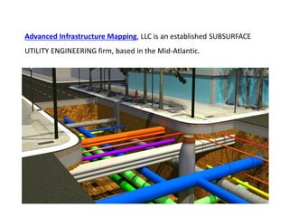
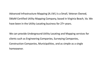
Advanced Infrastructure Mapping, LLC is an established SUBSURFACE
UTILITY ENGINEERING firm, based in the Mid-Atlantic.
Our vast knowledge of underground utility investigation techniques
help us strive to provide our customers with the most accurate
information possible.
Each one of our Project Manager has 25 to 30 years of underground utility
investigation experience.
With our dedicated commitment to quality, we can provide private utility
locating , designating , test holes (potholing), and small pipe camera
investigation.
AIM follows the strictest Data Collection Guidelines, found in CI/ASCE 38-02.
We guarantee you will be more than satisfied with the services provided by
Advanced Infrastructure Mapping, LLC.
Advanced Infrastructure Mapping, LLC provides subsurface utility
engineering (SUE) services to help in the design of underground
utilities, buildings, roadways, and any other civil infrastructure for
utility owners, designers, engineers, contractors, and even
homeowners.
PRIVATE UTILITY LOCATING/DESIGNATING
Whether it be a small area that needs to be checked and cleared for
private utilities or a large mapping project(Utilities Survey), our team can
provide all the necessary utility locating services you could ever need.
We use the most current and accurate utility locating equipment on
the market. Our equipment is always calibrated and in good working
order.
TEST HOLES/POTHOLING
Test holes are commonly used to determine the “true” elevation of an
existing underground utility. We can achieve this information with
vacuum excavation, which is the highest quality level in the S.U. E
process.
Vacuum Excavation is a process where high pressure air or water is
shot into the ground to loosen the material ( dirt, gravel, clay, etc.)
around a utility line.
The loose material is then vacuumed out, hence exposing the desired
utility. We now can gather all the necessary information needed to
identify the utility and it’s elevation.
PIPE INVESTIGATION
Camera investigation is a great way to explore existing unpressurized
pipes from the inside.
We can fish a small fiber optic camera through a questionable pipe,
with 360 degree visibility, to see if it is damaged or clogged at any given
point.
Most Homeowners And Contractors don’t know that 85% of all
utilities are underground. And that 65% of those are privately owned.
Basically, a privately owned utility is one that comes after a meter.
Utility Owners or their Contractors, that are members of the
“Miss Utility” notification system, will only mark the public
utilities up to your meter.
You, the business owner or homeowner are responsible for
having these “Private” lines located if your are planning on
digging or designing a future project.
The small fees that we charge are a small price to pay compared to
all of the SCC ( State Corporation Commission) fines, Utility
Company fines, change order costs, and the high costs to repair
damaged utilities if you don’t call.
1. Reduction in unforeseen utility conflicts and relocations;
2. Reduction in project delays due to utility relocates;
3. Reduction in claims and change orders;
4. Reduction in delays due to utility cuts;
5. Reduction in project contingency fees;
6. Lower project bids;
7. Reduction in costs caused by conflict redesign;
8. Reduction in the cost of project design;
9. Reduction in travel delays during construction to the motoring public;
10. Improvement in contractor productivity and quality;
11. Reduction in utility companies' cost to repair damaged facilities;
12. Minimization of utility customers' loss of service;
13. Minimization of damage to existing pavements;
14. Minimization of traffic disruption, increasing DOT public credibility;
15. Improvement in working relationships between DOT and utilities;
16. Increased efficiency of surveying activities by elimination of duplicate surveys;
17. Facilitation of electronic mapping accuracy;
18. Minimization of the chance of environmental damage;
19. Inducement of savings in risk management and insurance;
20. Introduction of the concept of a comprehensive SUE process;
21. Reduction in Right-of-Way acquisition costs.
Advanced Infrastructure Mapping (A.I.M.) is a Small, Veteran Owned,
SWaM Certified Utility Mapping Company, based in Virginia Beach, Va. We
have been in the Utility Locating business for 27+ years.
We can provide Underground Utility Locating and Mapping services for
clients such as Engineering Companies, Surveying Companies,
Construction Companies, Municipalities, and as simple as a single
homeowner.
Where we provide our services?
We provide our services in & around Virginia Beach, Va.
Address: 2216 Mansion Cross Ln., Virginia Beach, VA 23456
Call us: 757-785-5177
Email us: info@aimlocatingva.com
Website: http://www.aimlocatingva.com/
Monday – Saturday: 8:00 am – 5:00 pm
Sunday: Closed
GET IN TOUCH
Utility mapping services in virginia beach, va

Utility mapping services in virginia beach, va

  • 1.
    Utility Mapping Services inVirginia Beach, VA
  • 3.
    Advanced Infrastructure Mapping,LLC is an established SUBSURFACE UTILITY ENGINEERING firm, based in the Mid-Atlantic.
  • 5.
    Our vast knowledgeof underground utility investigation techniques help us strive to provide our customers with the most accurate information possible.
  • 7.
    Each one ofour Project Manager has 25 to 30 years of underground utility investigation experience. With our dedicated commitment to quality, we can provide private utility locating , designating , test holes (potholing), and small pipe camera investigation.
  • 8.
    AIM follows thestrictest Data Collection Guidelines, found in CI/ASCE 38-02. We guarantee you will be more than satisfied with the services provided by Advanced Infrastructure Mapping, LLC.
  • 10.
    Advanced Infrastructure Mapping,LLC provides subsurface utility engineering (SUE) services to help in the design of underground utilities, buildings, roadways, and any other civil infrastructure for utility owners, designers, engineers, contractors, and even homeowners.
  • 11.
    PRIVATE UTILITY LOCATING/DESIGNATING Whetherit be a small area that needs to be checked and cleared for private utilities or a large mapping project(Utilities Survey), our team can provide all the necessary utility locating services you could ever need.
  • 12.
    We use themost current and accurate utility locating equipment on the market. Our equipment is always calibrated and in good working order.
  • 13.
    TEST HOLES/POTHOLING Test holesare commonly used to determine the “true” elevation of an existing underground utility. We can achieve this information with vacuum excavation, which is the highest quality level in the S.U. E process.
  • 14.
    Vacuum Excavation isa process where high pressure air or water is shot into the ground to loosen the material ( dirt, gravel, clay, etc.) around a utility line. The loose material is then vacuumed out, hence exposing the desired utility. We now can gather all the necessary information needed to identify the utility and it’s elevation.
  • 15.
    PIPE INVESTIGATION Camera investigationis a great way to explore existing unpressurized pipes from the inside. We can fish a small fiber optic camera through a questionable pipe, with 360 degree visibility, to see if it is damaged or clogged at any given point.
  • 17.
    Most Homeowners AndContractors don’t know that 85% of all utilities are underground. And that 65% of those are privately owned. Basically, a privately owned utility is one that comes after a meter.
  • 18.
    Utility Owners ortheir Contractors, that are members of the “Miss Utility” notification system, will only mark the public utilities up to your meter. You, the business owner or homeowner are responsible for having these “Private” lines located if your are planning on digging or designing a future project.
  • 19.
    The small feesthat we charge are a small price to pay compared to all of the SCC ( State Corporation Commission) fines, Utility Company fines, change order costs, and the high costs to repair damaged utilities if you don’t call.
  • 21.
    1. Reduction inunforeseen utility conflicts and relocations; 2. Reduction in project delays due to utility relocates; 3. Reduction in claims and change orders; 4. Reduction in delays due to utility cuts; 5. Reduction in project contingency fees; 6. Lower project bids; 7. Reduction in costs caused by conflict redesign; 8. Reduction in the cost of project design; 9. Reduction in travel delays during construction to the motoring public; 10. Improvement in contractor productivity and quality;
  • 22.
    11. Reduction inutility companies' cost to repair damaged facilities; 12. Minimization of utility customers' loss of service; 13. Minimization of damage to existing pavements; 14. Minimization of traffic disruption, increasing DOT public credibility; 15. Improvement in working relationships between DOT and utilities; 16. Increased efficiency of surveying activities by elimination of duplicate surveys; 17. Facilitation of electronic mapping accuracy; 18. Minimization of the chance of environmental damage; 19. Inducement of savings in risk management and insurance; 20. Introduction of the concept of a comprehensive SUE process; 21. Reduction in Right-of-Way acquisition costs.
  • 24.
    Advanced Infrastructure Mapping(A.I.M.) is a Small, Veteran Owned, SWaM Certified Utility Mapping Company, based in Virginia Beach, Va. We have been in the Utility Locating business for 27+ years. We can provide Underground Utility Locating and Mapping services for clients such as Engineering Companies, Surveying Companies, Construction Companies, Municipalities, and as simple as a single homeowner.
  • 25.
    Where we provideour services?
  • 26.
    We provide ourservices in & around Virginia Beach, Va. Address: 2216 Mansion Cross Ln., Virginia Beach, VA 23456 Call us: 757-785-5177 Email us: info@aimlocatingva.com Website: http://www.aimlocatingva.com/ Monday – Saturday: 8:00 am – 5:00 pm Sunday: Closed GET IN TOUCH