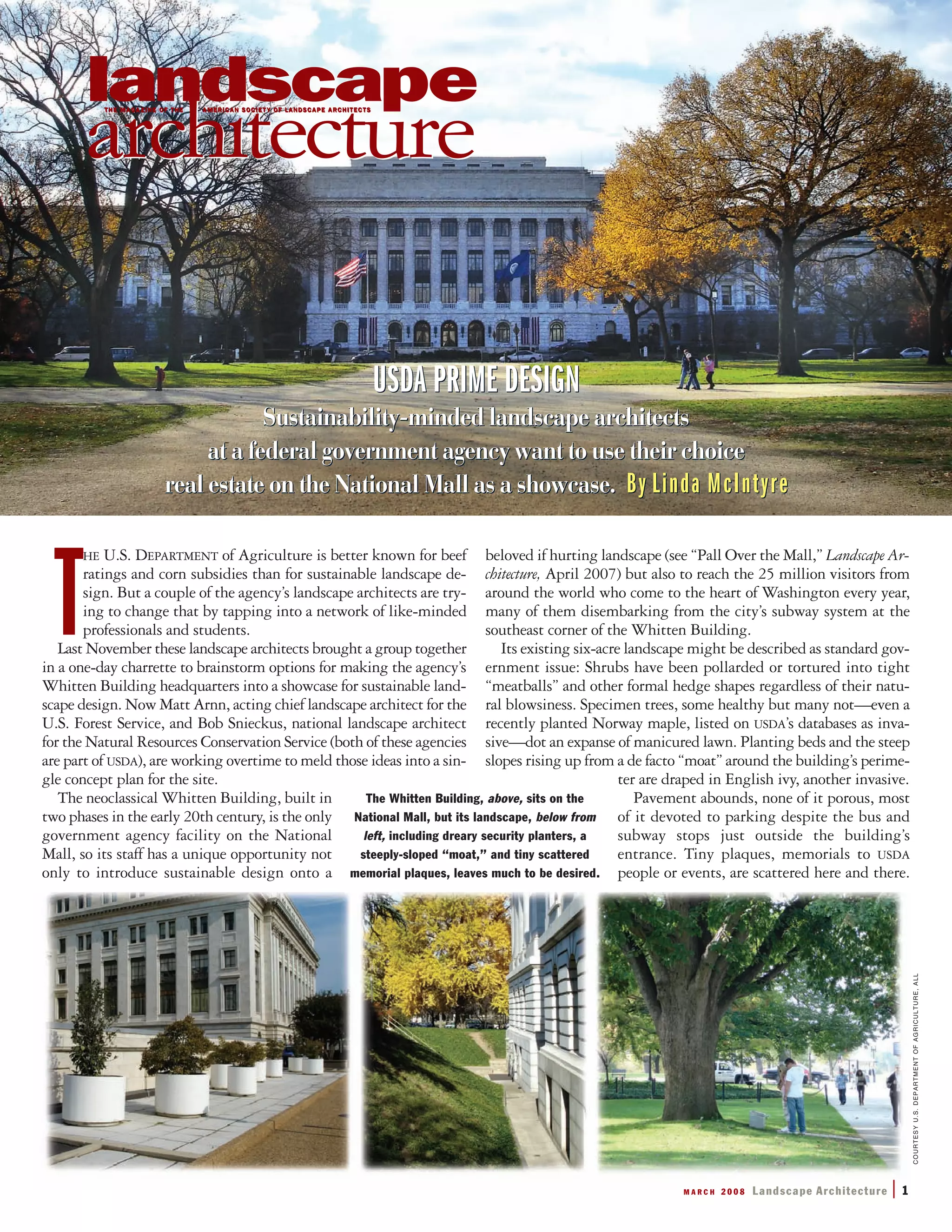
Landscape architects at the USDA held a one-day design charrette to develop concepts for transforming the landscape at the agency's headquarters building on the National Mall in Washington D.C. into a more sustainable design. The existing 6-acre landscape was described as standard but dull, with overabundant pavement and parking, invasive plants, and steep slopes. During the charrette, 75 professionals, students, and agency employees broke into 7 teams to develop concepts for different zones. Common ideas included reducing parking, infiltrating stormwater, adding native plants and habitat gardens, and improving the landscape's visual quality and function. The landscape architects are now working to combine the concepts into a single plan to showcase sustainable design on prominent federal property
Site planning in Architectural Projects- Principles and ApproachesJIT KUMAR GUPTA
Paper makes an attempt to define the process, elements and principles which should be considered for site planning in the architectural projects. Paper also defines the role and importance of the site planning in planning, designing and making the projects sustainable.
Urban Water Quality Issues - Green Design & Developmentnacaa
The document discusses green design and development which aims to minimize environmental impacts through practices like reducing impervious surfaces, preserving open spaces, and using low impact development (LID) approaches to better manage stormwater runoff. It provides examples of specific LID techniques like bioretention cells, permeable pavements, vegetated swales, and green roofs that can be integrated into site planning and building design. The goals are to protect water resources by maintaining natural hydrologic functions and reducing flooding, pollution, and development costs.
Prevailing Theories of Change(ToC) on ASB Partnership timeline:
ToC -1: Shifting cultivation is a major driver of deforestation, modernizing agriculture saves forests.- before 1993. Intensifying agriculture to obtain higher yields per ha reduces land pressure on forest & deforestation (‘Borlaug hypothesis’) 1993-1995
ToC 2A: Tradeoffs between private and public benefits of land use can be quantified; knowing opportunity costs of environmental services frames policy;
ToC 2B: Landscape mosaics (varying on segregated versus integrated axis) shape multi-scale outcomes; require Negotiation Support for change
ToC 2C: Landscape mosaics require fair + efficient reward mechanisms and/or coinvestment in ES
TOC 3A: Landscape-scale coinvestment in ES supports Reducing Emissions from All Land Uses (REALU as REDD++ alternative)
ToC 3B: Multi-scale, multi-paradigm combi-nation of national com-modification and local coinvestment for land-based NAMA’s/LAAMA’s
ToC 3C:
Idem for Sustainable Development Goals;
Visual composition refers to the arrangement of elements within the frame of an image or video. Some key principles of visual composition include avoiding unnecessary elements, observing the rule of thirds to emphasize subjects, maintaining balance and simplicity, and keeping elements orderly. Composition establishes depth, emphasis and flow through techniques like selective focus, asymmetrical balance, contrast, color, leading lines and more. Proper composition varies by aspect ratio and shot type or distance from the subject.
This presentation is a compilation of selected topics on the history of urbanization, urban and regional planning theories, urban thinkers and their contributes, concepts, bases of land use, applicability to the Philippine setting, and a briefer of urban design elements.
The document discusses several important planning concepts including:
1) Garden City Concept by Ebenezer Howard which proposed planned, self-contained communities surrounded by greenbelts that combined the benefits of both urban and rural living.
2) Geddesian Triad by Patrick Geddes which emphasized the organic relationship between social, physical, and economic environments in planning.
3) Neighborhood Unit concept by Clarence Perry which proposed planning residential areas with schools, parks, and shops at their core to create self-sufficient neighborhoods.
4) Radburn Concept by Clarence Stein and Henry Wright which pioneered the separation of pedestrian and vehicular traffic in planned communities.
Land use planning refers to allocating land resources for different uses consistent with development goals. It involves classifying land, determining suitable land uses, and regulating development through tools like zoning maps and land use plans. The objectives are to promote efficient land use, reconcile conflicts, and guide sustainable development patterns. Land use planning organizations at the national, regional, and local levels coordinate to classify land and guide land allocation and conversion nationally and within their jurisdictions.
The Northeast group summarized their concept plan for the Northeast zone of the Whitten Building landscape, which included the area at the corner of Jefferson Drive and 12th Street. Their plan aimed to connect to the Mall, enliven the space for day and night use, demonstrate USDA's mission through sustainable practices, connect to the Farmer's Market, create a sense of place or identity, and educate and inspire through a model landscape. They identified issues like poor soil, hydrology and parking lot runoff, and proposed big ideas like connecting green museums, children's activities, a memorial of nature, and front yard activities.
City Trees Washington Park_selected-pagesJenny Gulick
This document summarizes the steps taken to successfully protect trees during an extensive park renovation project in Washington Park in Cincinnati, Ohio. It describes the following key events:
1) A tree inventory was conducted of 118 trees before construction began to assess their condition and risks.
2) The construction plans were analyzed against the tree data to understand how the project would impact trees and modifications were made to relocate infrastructure to preserve more trees.
3) The landscape architect collaborated with the arborist and engineers to modify the design plans as needed based on the tree assessment, agreeing to remove some trees but preserve the majority through protection measures.
4) Strict language on tree protection specifications and penalties for noncompliance were
The document is a portfolio from landscape architect J. Christopher Ray showcasing several of his design projects. It includes summaries of a scattered site urban infill redevelopment in Hazelwood that incorporates new pedestrian pathways, a design for a living wall at UPMC Mercy Hospital using a double helix pattern, and a master plan for a 59-acre site in Cranberry Township featuring mixed-use development organized around preserved green spaces. The portfolio demonstrates Ray's focus on connecting spaces to their contexts and users through thoughtful forms and arrangements.
how to write budget and time frame for research.pptxSinafikeBekele
The High Line park in New York City was created from an abandoned elevated railway on Manhattan's West Side. James Corner Field Operations designed the High Line to have a wild, natural landscape growing along the 1.5 mile long and 30-88 foot wide path. By 2010, the first section of the park opened to the public, revitalizing the neighborhoods along the High Line with new investment, residents, and businesses. The design incorporated the industrial materials and embedded tracks of the original railway into an unstructured planting system. This created a unique linear urban park experience above the city.
The document discusses the concept of "designing with nature" and applying systems thinking to address sustainability challenges like climate change. It examines examples of where applying "levers" or interventions at leverage points in systems, like improving housing to reduce asthma in one neighborhood or establishing food processing in Chicago, had disproportionate positive impacts. The document argues that identifying leverage points can help trigger meaningful changes and advocates planning that engages communities and inspires vision.
The document summarizes a project to design Hunters Point South Waterfront Park and infrastructure in Queens, New York. The author served as the overall design lead, coordinating the design team and securing public approvals. The project aimed to create an innovative, sustainable waterfront park and neighborhood that could serve as a model for future city projects. It featured designs for the park, streets, and green infrastructure systems to balance new housing development while connecting residents to the waterfront.
Daniel Power graduated from the University of Michigan School of Natural Resources and Environment with a Master of Landscape Architecture in 2012. He has experience with several redevelopment and planning projects focused on sustainable and community-driven design. One project involved remediating and redeveloping a former industrial site in Saginaw, Michigan into a business park that incorporates the site's history and ecology. Another analyzed variables influencing landscape care in vacant Detroit neighborhoods to identify opportunities for stabilization. A third provided a regional ecological analysis and conceptual designs to guide sustainable neighborhood development in legacy cities. Additionally, Daniel designed an accessible athletic complex and nature trail for Saline High School that celebrates the site's cultural and environmental context.
The document provides information about J. Christopher Ray's landscape architecture portfolio. It includes a design philosophy statement emphasizing the importance of connecting form and function with users and nature. It then summarizes several of Ray's design projects from graduate school focusing on urban infill, community parks, and campus site designs. The projects aimed to create harmony and inspire users through thoughtful arrangements of space, vegetation and materials.
This document provides an overview of several topics related to watershed and conservation issues, including:
1) Wildfires and other natural hazards are worsening due to climate change, damaging watersheds.
2) Green infrastructure is often more cost-effective than traditional "grey" infrastructure for stormwater management and provides additional benefits.
3) Agriculture is facing challenges including farm consolidation reducing smaller farms, losses for corn farmers, and widespread land degradation impacting productivity.
Joseph Butts seeks a position as a landscape designer with over 10 years of experience in landscape design, construction, research, and management. He has a background in landscape architecture, marine sciences, and carpentry/toymaking. Notable projects include designing sustainable developments in Costa Rica, improving public spaces in Atlanta through design charrettes, and creating an interactive garden for a music venue in Athens, GA. Butts emphasizes hands-on learning and takes a de-centered, process-oriented approach to design.
Planning staff have proposed amendments to the Landscape and Land Use Buffers Ordinance to preserve existing trees and create a healthier environment for trees in new developments. The proposed changes include reducing the number of required interior trees, creating overall canopy requirements, and requiring landscape and tree protection plans earlier in the development process. These changes aim to provide suitable growing conditions for trees while maintaining landscaping requirements. A public hearing on the proposed amendments has been scheduled for May 14th. Additionally, construction has begun on new Culver's and Panera Bread locations, and upcoming projects include a new Toyota engineering building and expansion of Bluegrass Community and Technical College.
This document describes a collaborative student project to create educational materials about the Prairie Club and its efforts to conserve the Indiana Dunes. A team of 12 students from various departments researched the natural and cultural history of the dunes. They then created 11 film shorts, 11 poster illustrations, and 2 children's books to communicate the Prairie Club's contribution to conserving the Indiana Dunes. The materials were showcased on campus and at Indiana Dunes State Park.
This document is Alice Sturm's landscape architecture portfolio, which includes:
1) Personal details and introduction emphasizing her interests in working landscapes, climate change adaptation, and community engagement.
2) Examples of her academic and professional work, including student projects focused on flood resilience and recreation along the Poestenkill River in Troy, NY, and a climate adaptive design for Hudson, NY's waterfront.
3) Details of awards and positions held, including second place in the Better Philadelphia design competition for a proposal to extend Philadelphia's Rail Park.
4) Sections showing her skills in design, modeling, graphics, and construction documentation.
This document discusses several case studies of new parks projects in Europe and North America that address connectivity, placemaking, sustainability, and economic development. It summarizes the Emscher Park project in Duisburg, Germany, which reclaimed over 120 brownfield sites covering 70 square kilometers and connected them with trails as part of a large-scale regional redevelopment effort. It also describes the Westergasfabriek park in Amsterdam, which involved extensive community engagement to redevelop a contaminated gasworks site, and the Menomonee River Valley park in Milwaukee, which opened over 60 acres of former industrial land to the public and improved trails, bridges, and stormwater management.
This document summarizes a symposium to conceptualize a new vision for Boston City Hall, the Plaza, and Government Center. The goals are to identify sustainability best practices and innovative ideas to green the area and catalyze greening throughout Government Center. Experts will provide feasible and cutting-edge solutions for buildings, City Hall, and the Plaza, setting sustainability criteria. Multiple comprehensive visions will be crafted to revitalize the Plaza's spaces and accommodate public uses. Key issues and goals will be identified for a subsequent design charrette.
Landscape Architecture works from undergraduate studios at ASU. Work ranging from scale of intimate, yet impactful site design to large, regional analysis of urban systems.
The document discusses several contemporary landscape projects from around the world:
1) Crissy Field in San Francisco restored natural wetlands while integrating recreational uses.
2) The Herman Miller factory landscape in Georgia treated stormwater runoff to protect local ecosystems.
3) Lurie Garden in Chicago's Millennium Park references the Midwest prairie with native plants.
4) Al-Azhar Park in Cairo transformed a garbage dump into an oasis and stimulated neighborhood revitalization.
This document provides an overview of the sustainable design principles utilized in the Village Homes residential development in Davis, California. It discusses how the developers designed the community to be centered around people rather than automobiles by narrowing streets, incorporating shared green spaces and agricultural land, and orienting homes to maximize passive solar gain. Specific sustainable features discussed include super insulated walls, passive solar water heating, and photovoltaic solar arrays. The document argues that rethinking conventional residential development approaches can improve quality of life while reducing environmental impacts and costs.
More Related Content
Similar to USDA - Beneficial Landscaping Prime Design
The Northeast group summarized their concept plan for the Northeast zone of the Whitten Building landscape, which included the area at the corner of Jefferson Drive and 12th Street. Their plan aimed to connect to the Mall, enliven the space for day and night use, demonstrate USDA's mission through sustainable practices, connect to the Farmer's Market, create a sense of place or identity, and educate and inspire through a model landscape. They identified issues like poor soil, hydrology and parking lot runoff, and proposed big ideas like connecting green museums, children's activities, a memorial of nature, and front yard activities.
City Trees Washington Park_selected-pagesJenny Gulick
This document summarizes the steps taken to successfully protect trees during an extensive park renovation project in Washington Park in Cincinnati, Ohio. It describes the following key events:
1) A tree inventory was conducted of 118 trees before construction began to assess their condition and risks.
2) The construction plans were analyzed against the tree data to understand how the project would impact trees and modifications were made to relocate infrastructure to preserve more trees.
3) The landscape architect collaborated with the arborist and engineers to modify the design plans as needed based on the tree assessment, agreeing to remove some trees but preserve the majority through protection measures.
4) Strict language on tree protection specifications and penalties for noncompliance were
The document is a portfolio from landscape architect J. Christopher Ray showcasing several of his design projects. It includes summaries of a scattered site urban infill redevelopment in Hazelwood that incorporates new pedestrian pathways, a design for a living wall at UPMC Mercy Hospital using a double helix pattern, and a master plan for a 59-acre site in Cranberry Township featuring mixed-use development organized around preserved green spaces. The portfolio demonstrates Ray's focus on connecting spaces to their contexts and users through thoughtful forms and arrangements.
how to write budget and time frame for research.pptxSinafikeBekele
The High Line park in New York City was created from an abandoned elevated railway on Manhattan's West Side. James Corner Field Operations designed the High Line to have a wild, natural landscape growing along the 1.5 mile long and 30-88 foot wide path. By 2010, the first section of the park opened to the public, revitalizing the neighborhoods along the High Line with new investment, residents, and businesses. The design incorporated the industrial materials and embedded tracks of the original railway into an unstructured planting system. This created a unique linear urban park experience above the city.
The document discusses the concept of "designing with nature" and applying systems thinking to address sustainability challenges like climate change. It examines examples of where applying "levers" or interventions at leverage points in systems, like improving housing to reduce asthma in one neighborhood or establishing food processing in Chicago, had disproportionate positive impacts. The document argues that identifying leverage points can help trigger meaningful changes and advocates planning that engages communities and inspires vision.
The document summarizes a project to design Hunters Point South Waterfront Park and infrastructure in Queens, New York. The author served as the overall design lead, coordinating the design team and securing public approvals. The project aimed to create an innovative, sustainable waterfront park and neighborhood that could serve as a model for future city projects. It featured designs for the park, streets, and green infrastructure systems to balance new housing development while connecting residents to the waterfront.
Daniel Power graduated from the University of Michigan School of Natural Resources and Environment with a Master of Landscape Architecture in 2012. He has experience with several redevelopment and planning projects focused on sustainable and community-driven design. One project involved remediating and redeveloping a former industrial site in Saginaw, Michigan into a business park that incorporates the site's history and ecology. Another analyzed variables influencing landscape care in vacant Detroit neighborhoods to identify opportunities for stabilization. A third provided a regional ecological analysis and conceptual designs to guide sustainable neighborhood development in legacy cities. Additionally, Daniel designed an accessible athletic complex and nature trail for Saline High School that celebrates the site's cultural and environmental context.
The document provides information about J. Christopher Ray's landscape architecture portfolio. It includes a design philosophy statement emphasizing the importance of connecting form and function with users and nature. It then summarizes several of Ray's design projects from graduate school focusing on urban infill, community parks, and campus site designs. The projects aimed to create harmony and inspire users through thoughtful arrangements of space, vegetation and materials.
This document provides an overview of several topics related to watershed and conservation issues, including:
1) Wildfires and other natural hazards are worsening due to climate change, damaging watersheds.
2) Green infrastructure is often more cost-effective than traditional "grey" infrastructure for stormwater management and provides additional benefits.
3) Agriculture is facing challenges including farm consolidation reducing smaller farms, losses for corn farmers, and widespread land degradation impacting productivity.
Joseph Butts seeks a position as a landscape designer with over 10 years of experience in landscape design, construction, research, and management. He has a background in landscape architecture, marine sciences, and carpentry/toymaking. Notable projects include designing sustainable developments in Costa Rica, improving public spaces in Atlanta through design charrettes, and creating an interactive garden for a music venue in Athens, GA. Butts emphasizes hands-on learning and takes a de-centered, process-oriented approach to design.
Planning staff have proposed amendments to the Landscape and Land Use Buffers Ordinance to preserve existing trees and create a healthier environment for trees in new developments. The proposed changes include reducing the number of required interior trees, creating overall canopy requirements, and requiring landscape and tree protection plans earlier in the development process. These changes aim to provide suitable growing conditions for trees while maintaining landscaping requirements. A public hearing on the proposed amendments has been scheduled for May 14th. Additionally, construction has begun on new Culver's and Panera Bread locations, and upcoming projects include a new Toyota engineering building and expansion of Bluegrass Community and Technical College.
This document describes a collaborative student project to create educational materials about the Prairie Club and its efforts to conserve the Indiana Dunes. A team of 12 students from various departments researched the natural and cultural history of the dunes. They then created 11 film shorts, 11 poster illustrations, and 2 children's books to communicate the Prairie Club's contribution to conserving the Indiana Dunes. The materials were showcased on campus and at Indiana Dunes State Park.
This document is Alice Sturm's landscape architecture portfolio, which includes:
1) Personal details and introduction emphasizing her interests in working landscapes, climate change adaptation, and community engagement.
2) Examples of her academic and professional work, including student projects focused on flood resilience and recreation along the Poestenkill River in Troy, NY, and a climate adaptive design for Hudson, NY's waterfront.
3) Details of awards and positions held, including second place in the Better Philadelphia design competition for a proposal to extend Philadelphia's Rail Park.
4) Sections showing her skills in design, modeling, graphics, and construction documentation.
This document discusses several case studies of new parks projects in Europe and North America that address connectivity, placemaking, sustainability, and economic development. It summarizes the Emscher Park project in Duisburg, Germany, which reclaimed over 120 brownfield sites covering 70 square kilometers and connected them with trails as part of a large-scale regional redevelopment effort. It also describes the Westergasfabriek park in Amsterdam, which involved extensive community engagement to redevelop a contaminated gasworks site, and the Menomonee River Valley park in Milwaukee, which opened over 60 acres of former industrial land to the public and improved trails, bridges, and stormwater management.
This document summarizes a symposium to conceptualize a new vision for Boston City Hall, the Plaza, and Government Center. The goals are to identify sustainability best practices and innovative ideas to green the area and catalyze greening throughout Government Center. Experts will provide feasible and cutting-edge solutions for buildings, City Hall, and the Plaza, setting sustainability criteria. Multiple comprehensive visions will be crafted to revitalize the Plaza's spaces and accommodate public uses. Key issues and goals will be identified for a subsequent design charrette.
Landscape Architecture works from undergraduate studios at ASU. Work ranging from scale of intimate, yet impactful site design to large, regional analysis of urban systems.
The document discusses several contemporary landscape projects from around the world:
1) Crissy Field in San Francisco restored natural wetlands while integrating recreational uses.
2) The Herman Miller factory landscape in Georgia treated stormwater runoff to protect local ecosystems.
3) Lurie Garden in Chicago's Millennium Park references the Midwest prairie with native plants.
4) Al-Azhar Park in Cairo transformed a garbage dump into an oasis and stimulated neighborhood revitalization.
This document provides an overview of the sustainable design principles utilized in the Village Homes residential development in Davis, California. It discusses how the developers designed the community to be centered around people rather than automobiles by narrowing streets, incorporating shared green spaces and agricultural land, and orienting homes to maximize passive solar gain. Specific sustainable features discussed include super insulated walls, passive solar water heating, and photovoltaic solar arrays. The document argues that rethinking conventional residential development approaches can improve quality of life while reducing environmental impacts and costs.
Similar to USDA - Beneficial Landscaping Prime Design (20)
1. T
HE U.S. DEPARTMENT of Agriculture is better known for beef
ratings and corn subsidies than for sustainable landscape de-
sign. But a couple of the agency’s landscape architects are try-
ing to change that by tapping into a network of like-minded
professionals and students.
Last November these landscape architects brought a group together
in a one-day charrette to brainstorm options for making the agency’s
Whitten Building headquarters into a showcase for sustainable land-
scape design. Now Matt Arnn, acting chief landscape architect for the
U.S. Forest Service, and Bob Snieckus, national landscape architect
for the Natural Resources Conservation Service (both of these agencies
are part of USDA), are working overtime to meld those ideas into a sin-
gle concept plan for the site.
The neoclassical Whitten Building, built in
two phases in the early 20th century, is the only
government agency facility on the National
Mall, so its staff has a unique opportunity not
only to introduce sustainable design onto a
beloved if hurting landscape (see “Pall Over the Mall,” Landscape Ar-
chitecture, April 2007) but also to reach the 25 million visitors from
around the world who come to the heart of Washington every year,
many of them disembarking from the city’s subway system at the
southeast corner of the Whitten Building.
Its existing six-acre landscape might be described as standard gov-
ernment issue: Shrubs have been pollarded or tortured into tight
“meatballs” and other formal hedge shapes regardless of their natu-
ral blowsiness. Specimen trees, some healthy but many not—even a
recently planted Norway maple, listed on USDA’s databases as inva-
sive—dot an expanse of manicured lawn. Planting beds and the steep
slopes rising up from a de facto “moat” around the building’s perime-
ter are draped in English ivy, another invasive.
Pavement abounds, none of it porous, most
of it devoted to parking despite the bus and
subway stops just outside the building’s
entrance. Tiny plaques, memorials to USDA
people or events, are scattered here and there.
The Whitten Building, above, sits on the
National Mall, but its landscape, below from
left, including dreary security planters, a
steeply-sloped “moat,” and tiny scattered
memorial plaques, leaves much to be desired.
COURTESYU.S.DEPARTMENTOFAGRICULTURE,ALL
USDA PRIME DESIGN
Sustainability-minded landscape architects
at a federal government agency want to use their choice
real estate on the National Mall as a showcase. By Linda McIntyre
USDA PRIME DESIGN
Sustainability-minded landscape architects
at a federal government agency want to use their choice
real estate on the National Mall as a showcase. By Linda McIntyre
USDA PRIME DESIGN
Sustainability-minded landscape architects
at a federal government agency want to use their choice
real estate on the National Mall as a showcase. By Linda McIntyre
USDA PRIME DESIGN
Sustainability-minded landscape architects
at a federal government agency want to use their choice
real estate on the National Mall as a showcase. By Linda McIntyre
M A R C H 2 0 0 8 Landscape Architecture | 1
2. The classical grandeur of the main entrance is marred by asphalt,
parked cars, and a yellow-and-black-striped entry arm. Leaving aside
a few exceptional spots—some gorgeous mature ginkgoes and other
trees near the northwest corner of the building, a little green roof on
a utility outbuilding at the back, a seasonal farmers’ market—this
landscape is not only not sustainable, but most of it is humdrum
and some is downright ugly.
It’s expensive too. Bedding plants—spring bulbs, summer flowers,
and cold-tolerant annuals—are switched out three times every year,
contributing to annual maintenance costs of
more than $240,000. And this uninspired
landscape requires more than 30,000 gal-
lons of water every summer.
USDA employees have for years initiated
sustainability projects through informal
“green teams” at agency outposts throughout
the country. The green team for the Whitten
Building hit on the notion of using their
high-profile landscape to implement such
policies in a tangible way, but they needed
help managing the design process. Ed Hog-
berg and Ed Murtagh, both enthusiastic
green team members working in the Office
of Operations—the make-or-break place for
big agency projects—refined the notion of
using the landscape to make their policies vis-
ible into a proposed agency-wide partnership.
This would not only help ensure viability of
the project over the longer term but also serve
as a model for other public institutions.
When they approached Forest Service
Recreation Director Jim Bedwell, who had previously
served as that agency’s chief landscape architect, to
discuss what his staff might be able to contribute,
Bedwell suggested that a landscape architect was in-
tegral to the project and arranged for Arnn, then
based in New York City, to come on board for the
project. Arnn pulled in Snieckus after learning about
his work from another green team member, and they
decided to broaden the effort beyond the agency with
a one-day charrette.
“Wereachedouttofriendsandcontacts,”including
other landscape architects, architects, horticulturists,
landscapearchitecturestudents,andpeopleinterested
in the Mall, says Arnn. They wanted to identify peo-
ple who would be champions for the project, both
within and outside USDA, hoping to draw to-
gether about 30 people. “So we invited 40,”
says Snieckus, “and 75 showed up.”
T
O MAKE THE BEST USE of their limited
time, Arnn and Snieckus broke the
group into seven teams, each led by a fa-
cilitator and assigned to brainstorm ideas for a different chunk of
the Whitten landscape. Participants were encouraged, however, to
think beyond the boundaries of their zones. Each team comprised
a mix of design professionals, advocates for the Mall, students, and
government employees. Time was tight—the teams only had about
two and a half hours to bang out a concept after a tour of the whole
site and a quick investigation of their own parcels.
Completing the whole charrette in a day
“would not have been our first choice,” says
Arnn, but taking more time out of the of-
fice would have been burdensome or im-
possible for most professionals. Some,
though, would have liked more time. “The
creativity was just getting going when the
time was up,” says landscape architect Ann
English. “I found myself drawing up ideas
the whole way home!” Focusing the teams
on small parts of the landscape, rather than
the site as a whole, also involved some
trade-offs for Arnn and Snieckus as they
knitted the components into a single con-
cept plan. But Arnn notes that it’s hard to
get a handle on such a large site in such a
small amount of time, and he says that the
approach got them a higher level of detail
than might have been expected.
Several consistent problem areas emerged.
The amount of space allocated to parking
Abundant parking, left, looks ugly and
contributes to drainage problems. Land-
scape architect Matt Arnn and USDA’s
John Crew, below, led participants on a
tour before the charrette began in earnest.
D E S I G N
Goals for the Charrette
☛1 Reduce stormwater runoff with rain
gardens, green roofs, and bioretention practices.
☛2 Create new habitat with pollinator gardens.
☛3 Educate the public with interpretive
signage and interactive features.
☛4 Reduce maintenance costs with high-
performing native plants.
☛5 Feature USDA agencies with thematic
elements and plants.
☛6 Improve the visual quality of the
headquarters landscape.
☛7 Provide learning opportunities for children.
☛8 Organize and provide for a living memorial
to people and events important to USDA’s history
and mission on site.
☛9 Enhance farmers’ market operations and
site integration.
2 | Landscape Architecture M A R C H 2 0 0 8
3. M A R C H 2 0 0 8 Landscape Architecture | 3
seemed preposterous to many in light of the subway and bus stops on
site, and it’s a visual blight on the landscape. The slopes around the
“moat” are too steep; even the invasive ivy planted on them is per-
forming poorly, and the slopes are not used to best effect given their
visibility from inside the building. The memorial plaques lack impact
in their current configuration. The landscape is not inviting and does-
n’t reflect the agency’s identity or mission, and it neither befits nor
takes advantage of its prime real estate on the National Mall.
Highlightsfrom
EachZoneTeam
NORTHWEST ZONE (please see graphic on page 4.)
This zone at the front corner of the building has good views to the
Mall and is well situated to be seen by visitors strolling among the
monuments. It’s perhaps the most attractive part of the existing land-
scape, owing mostly to some big and healthy specimen trees,
including a pair of ginkgoes, a linden, a bald cypress, and a white
oak, growing in a swath of good soil. Beyond these trees the land-
scape features include lawn, ivy, and tightly pruned shrubs.
The group envisaged a more lushly planted landscape of native
and edible plants with a more varied topography to add interest, di-
rect and infiltrate runoff, and teach visitors about stormwater man-
agement. The informality of the planting design would be offset by
a lawn to keep the landscape sympathetic to the building and pro-
vide a space for gathering and play. The group suggested adding seat-
ing and realigning the sidewalk along Jefferson Drive, removing the
declining street trees along the curb and planting them instead on the
USDA landscape where they would be more likely to grow and thrive,
providing pedestrians with much-needed shade.
NORTH ZONE (please see graphic on page 4.)
This is the grand main entrance to the building, looking out onto
the Mall and the Smithsonian Museum of American History on the
Mall’s north side. Its current treatment is more in line with a subur-
ban McMansion, though, than a grand government edifice. The group
Zone
Map
Zone
Map
The existing landscape is not in keeping with the building’s grand classical entrance, left. USDA staff “green teams” have already implemented some sustainable features
such as this green roof, right, on a utility building.
4. NORTHWEST TEAM
4 | Landscape Architecture M A R C H 2 0 0 8
Less-visible parking, below, would highlight the main entrance, above. Participants designed
concepts to highlight the agency’s mission, opposite top, and native plants, top.
NORTH TEAM
NORTH TEAM
D E S I G N
5. felt that the formality of the planting is in keeping with the style of the
building, but the dominance of the parking lot and overzealous main-
tenance of the plants greatly reduces its visual impact.
The group suggested a symmetrical but less-clipped planting
scheme and reducing the visibility of parking by offering less of it
and putting remaining cars on a lower grade behind a ha-ha wall.
Like several other groups, this one recommended easing the slope
around the moat with terracing and bioremediation measures.
NORTHEAST ZONE
This site, in the path of visitors walking from the
subway stop to the Mall and host to a Tourmobile
stop, has high visibility, but it’s a design hodgepodge.
Many of the street trees are in decline or missing, and
numerous memorial trees, a vegetable plot, and a
small temporary road into an adjacent parking lot nei-
ther stand as a coherent landscape nor enhance the
building.
The group felt that the prominence of the site
should encourage creative exploration. They proposed
a child-friendly design loosely organized on a farm
theme, with edible plants, a model of a barn and “pas-
ture” for play, and a memorial grove of trees.
EAST ZONE
This site greets visitors as they step outside the sub-
way, and the group lamented its current state as
“an assault on the image and integrity of the USDA.”
It’s mostly pavement and serves as a parking lot as
well as the site of a seasonal farmers’ market open to
the public.
The group drew up an ambitious concept plan that would close
this block of 12th Street on market days and locate vendors there.
Parking would be removed or drastically reduced, and paving on the
site would be porous. They would remove the curb to promote
stormwater collection and build a bioretention area. An arbor would
shade pedestrians on the sidewalk, and seasonal plots of edible plants
would be moved from the ad-jacent Northeast Zone to this site, par-
allel to the building, to help that zone capture more of a “front yard”
character in keeping with the building’s classical facade.
M A R C H 2 0 0 8 Landscape Architecture | 5
NORTHEAST TEAM
EAST TEAM
Bold ideas included shutting down a street, above,
for the popular farmers’ market. Most concepts in-
cluded ideas for infiltrating, left, and storing
stormwater on site, page 6, bottom right.
EAST TEAM
6. SOUTHEAST ZONE
This site at the rear of the building features extensive paving and
parking, as well as the usual ivy-covered slopes down to the
moat and unhealthy street trees. The uninviting Americans with
Disabilities Act-compliant building entrance is here. There’s also
a small abandoned outbuilding once used to store alcohol and
other flammable liquids when there were research labs on site.
The group decided to keep some parking on the site but add
bike racks and repave the space with reflective porous concrete to
infiltrate stormwater and mitigate the urban heat island effect that
plagues this area in summer. They would fit the edges of the park-
ing lot with a trellis planted with organic grapevines, spiff up the
building’s ADA-compliant entrance with new plants, and install
deep root cells under the sidewalk to promote healthier street
trees. The alcohol storage building would be cheekily resurrected
as a wine bar with a planted roof deck.
SOUTHWEST ZONE
The main features of this site are parking and a one-story utility
building. The building has a green roof, but it’s not visible to
passersby. As on other sites, steep slopes along the perimeter moat are
planted with ivy. The ivy and street trees here are performing poorly.
A row of security planters adds no interest.
The group felt that this zone had the worst visual quality of the
entire site, and they sought to improve its aesthetics while keeping
its essentially utilitarian function. They suggested tilting up the
green roof a bit to make it more visible and continuing its plant-
ing scheme in an educational display closer to ground level. Cis-
terns to collect runoff from this and other zones would be added
underground and possibly aboveground too. The slope down to
the moat would be terraced and rain gardens would be planted at
the bottom.
6 | Landscape Architecture M A R C H 2 0 0 8
D E S I G N
The Southeast team, above,
sought to improve rather
than eliminate parking, right.
SOUTHEAST TEAM
SOUTHWEST TEAM
The Southwest design would make the
green roof more visible to passersby.
7. WEST ZONE
This site features a lot of parking, but there’s more planted screen-
ing than in most other parking-heavy zones. Fourteenth Street,
the western boundary of the site, is a busy road on which many driv-
ers enter and exit the city. The Washington Monument and other
Mall attractions are visible. The stately trees in the Northwest Zone
add shade and beauty.
The West team, below,
proposed making that space a lush
“gateway” site, right, as well as
mitigating and replanting the
“moat” slopes, bottom.
WEST TEAM
WEST TEAM
“Asmuchaswe’recounting
ongoodideas,thekeyto
successoverthelongterm
willbethenetwork.”
8. Reprinted with permission from Landscape Architecture, March 2008, by The Reprint Dept., 800-259-0470; 10873-0408.
The group felt that the site has too much potential and visibility to
be used for parking. Instead they proposed a concept making it into a
lush “gateway” site, featuring a green memorial wall, rain and habitat
gardens, and a rocky area for play or just sitting.
ARNN AND SNIECKUS wasted no time in drawing up a written report of
the charrette, replete with images and details of the seven concepts, to
keep the momentum going within
the agency. “We got good feed-
back from colleagues after the
event,” Arnn told us shortly after-
ward. “They want to see results, so
we’re working quickly and trying
to be responsive.”
H
OW MUCH IMPACT is a
one-day charrette likely
to have on even a small
part of a huge federal
agency?
“Having worked in govern-
ment for most of my career, I
know it can move at glacial
speeds,” says Snieckus. “But I
have a very good feeling about
this, and the buzz created by the
charrette.” That buzz continued long after the event; Assistant
Secretary Boyd Rutherford told us in January that many ideas were
under consideration, including new approaches to parking.
“Everyone is excited about the project,” he says. As this article was
being written, the landscape architects were putting the finishing
touches on the report, preparing to refine the concepts and narrow
the choices, and hoping to break ground on the first project around
Earth Day.
But they hope the project will go on much longer. The Office
of Operations is looking into hiring a landscape architect to over-
see the long-term project, and Arnn and Snieckus want all of the
participants to stay involved. “As much as we’re counting on good
ideas, the key to success over the long term will be the network
and (participants’) sense of ownership over the process,” says Arnn.
And a lot of the participants were glad to be asked. Landscape
architect Eliott Rhodeside, who
has worked on big projects for
federal agencies and served as a
facilitator for the charrette, liked
the conviviality. “It was more
cerebral and creative than a con-
tractual process requiring
approval,” he says. “We had a lot
of freedom that isn’t typically
part of the process.”
“The most exciting thing was
that the USDA was reaching out,
saying, ‘This is your government,
this is your space, this is your
Mall—what do you want to be
there?’” says Rick Harlan Schnei-
der of Envision Design, who also
served as a facilitator.
“It’s hard to look back and enjoy
the day for what it was—an expression of energy,” says Arnn. “The
reality is that it’s part of a larger, longer-term process and vision for
an improved headquarters landscape. Until that happens, we’re not
taking anything for granted.” LAMLAM
Resources
■ Follow the progress of the USDA Sustainable Landscape Partnership
andtheconceptplanfortheWhittenBuilding at www.greening.usda.gov.
Landscape architect Matt Arnn immediately started working up detailed
sketches based on participants’ ideas.
D E S I G N
For web posting only. Bulk printing prohibited.