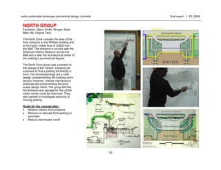
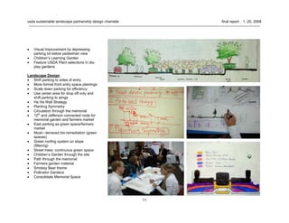
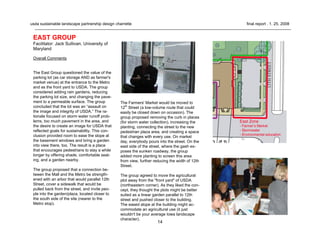
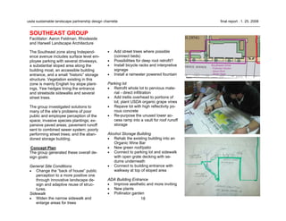
The Northeast group summarized their concept plan for the Northeast zone of the Whitten Building landscape, which included the area at the corner of Jefferson Drive and 12th Street. Their plan aimed to connect to the Mall, enliven the space for day and night use, demonstrate USDA's mission through sustainable practices, connect to the Farmer's Market, create a sense of place or identity, and educate and inspire through a model landscape. They identified issues like poor soil, hydrology and parking lot runoff, and proposed big ideas like connecting green museums, children's activities, a memorial of nature, and front yard activities.
Best Practices In Land And Water ManagementJosé Jump
Government organizations need to serve farmer clients in more interdisciplinary and participatory ways
Re-orient agriculture and rural development programmes to promote and nurture active participation of farmers and their organizations
Target the production chain: GAP-LWM productivity + food quality markets health and nutrition
Participatory research and support services to facilitate transition from conventional agriculture to GAP-LWM
Restructure inappropriate macro-economic and agricultural policies
Adopt policies that promote and enforce sustainable and productive land and water use through GAP protocols
Protect the integrity of agricultural families – land tenure, build on indigenous knowledge, promote youth in agriculture, reduce labour/drudgery
Adjust legislation to facilitate initiatives of local groups adopting GAP (help meet their needs)
Presented by T. Pagella, M. Cronin, G. Lamond, T. Sida and F.L. Sinclair at the Nile Basin Development Challenge (NBDC) Science Workshop, Addis Ababa, Ethiopia, 9–10 July 2013
Systematic framework to assess restoration actions and outcomes based on meas...Richard Thackway
A unifying framework is presented for tracking the outcomes of intentional and unintentional land management practices on the condition components of plant communities. The framework is based on 22 indicators hierarchically organised into 10 functional, structural and compositional criteria. Changes in the values of criteria and indicators over time track the response of a plant community to land management practices. This involves a twostep process. First develop a systematic and comprehensive site-based chronology of land management practices over time. Second fully integrate relevant data and information on the responses of the plant community into the chronology of practices, actions and interventions. How, and to what degree, the practices effect the indicators is also recorded, including deliberate and/or inadvertent actions and outcomes. Data and information on the outcomes of actions is compiled from various sources including; direct measures of field-based attributes, estimates of attributes derived from expert elicitation, environmental histories, interviews with skilled subject specials and relevant metrics derived from multi-spatial and multi-temporal remote sensing datasets. Provided a competent ecologist has access to key resources, a preliminary assessment can be completed in three days. Indicators are scored separately using a metric 0-1, based on the response of the plant community’s indicator assessed relative to the indicator in the reference state. Indicator scores are aggregated and weighted separately for three components; functional (55%), structural (27%) and compositional (18%). The reference state is assigned 100%. This framework has been widely applied across major climate zones in Australia to track and explain observed decadal spatial and temporal changes in the condition of plant communities including changes due to restoration activities. Examples will be provided in how applications of this framework also provide insights in plant community resilience, possible system trajectories and future management options.
Sustainable Landscapes: Food Security and adapting to climate changeCIFOR-ICRAF
This presentation by Gernot Laganda shows the IFAD's point of view on landscapes: why they're so concerned with it, how climate change impact on agricultural landscapes and how the IFAD integrates land, food and climate systems.
Results of field testing the indicators for resilience of socio-ecological pr...Bioversity International
Presentation by Nadia Bergamini from Bioversity International.
This was presented during a seminar hosted at Bioversity International on 'The Indicators of Resilience in Socio-Ecological Production Landscapes and Seascapes (SEPLS)' in January 2014.
Find out more: http://www.bioversityinternational.org/research-portfolio/agricultural-ecosystems/landscapes/
LESSONS LEARNT FROM DEVELOPMENT PROJECTS TO RESTORE TANK CASCADESDr. P.B.Dharmasena
Presentation made at the Conference on ‘Cascade Ecology & Management – 2021’ held on 17-18 September 2021, Organized by the Faculty of Agriculture, Peradeniya, Sri Lanka.
This presentation provides a brief explanation about the site planning techniques and methods involved along with the landscaping techniques.
For more detailed study and to learn about the same topic, you may visit at - https://archistudent.net
This presentation focuses on watershed management which also takes climate change and the landscape approach into consideration. It shows measurements, drainage treatment, adaptive sustainable agriculture and much more.
Preserving and restoring parkland, protecting critical watersheds, maintaining native wildlife and plant species, and providing high quality recreational activities are important for the future of the parks. The purpose of a Sustainability Plan is to ensure that Ottawa County will be able to maintain its current practices and develop a strategy for future opportunities with an ever-growing population and increasing park use.
The plan identifies goals Ottawa County Parks aspires to accomplish within five years, at which time the plan will be reviewed. The goals are organized into Environmental, Economic, and Social Sustainability. Objectives and actions will be included to specify the exact steps that must be taken in order to reach the indicated goals. The plan will be available to the public to review later this year.
Conceptual Framing Landscape Approach in the field
USDA - Whitten Charrette Final Report 2-8-08
1. usda sustainable landscape partnership design charrette final report . 1. 25. 2008
usda sustainable landscape partnership
whitten building landscape design charrette
final report - January 2008
2. 2
usda sustainable landscape partnership design charrette final report . 1. 25. 2008
The Sustainable Landscape Partnership is a project of the United
States Department of Agriculture. Participating agencies include:
US Forest Service (FS),
Natural Resources Conservation Service (NRCS),
Agricultural Research Service (ARS),
Agricultural Marketing Service (AMS),
Departmental Administration (DA).
usda sustainable landscape partnership
whitten building landscape design charrette
final report . january 2008
3. 3
usda sustainable landscape partnership design charrette final report . 1. 25. 2008
INTRODUCTION
The November 30, 2007 Whitten Sustainable Landscape Design
Charrette brought together technical experts in the fields of
landscape architecture, horticulture, forestry, hydrology and
engineering to inspire a vision for the USDA Whitten Building
headquarters on the National Mall in Washington DC - one that
demonstrates environmentally responsible practices, educates
and engages the public via accessible exhibits, provides social
benefits for employees, and serves as a model for other public
institutions in the region.
The November 30, 2007charrette, sponsored by USDA Depart-
mental Administration, was a first effort by the USDA Sustainable
Landscape Partnership to motivate a network around this project
and move closer to realizing its goals to improve USDA National
Capital Region facilities:
• Reduce the environmental impacts of stormwater runoff and
provide wildlife habitat by using environmentally beneficial
landscaping.
• Use the landscape as a demonstration area site for tourists,
visitors, and employees. These living and accessible
educational exhibits will provide an opportunity for the public
to learn about environmental issues, about USDA programs
and initiatives, and what citizens can do in their own
backyards to help the environment.
• Maintain the project as a learning lab for our landscape
contractors by enlisting them to participate as partners and
using that knowledge at other facilities.
• Improve the appearance of the USDA grounds by using
plants and features that will add visual interest to the site.
• Highlight this partnership as a model and the landscape as a
showcase for sustainable site practices in the region.
4. 4
usda sustainable landscape partnership design charrette final report . 1. 25. 2008
BACKGROUND
The six acre Jamie L. Whitten building site
is bordered by 12th and 14th Streets SW
and by Independence and Jefferson Drive
SW. The Building, designed by Rankin,
Kellogg and Crane, it is one of USDA's
highest profile and most visited properties.
The Whitten landscape is a mix of mature
and newly planted trees, native and inva-
sive shrubs, and sprawling groundcovers
and lawn. The bedding material at this site
is rotated three times a year featuring
spring bulbs, annuals, and cold weather
bloomers. (Over 35,000 tulips, begonias
and geraniums are planted each season.)
The landscaping costs at the Whitten
Building exceed $240,000 annually.
Additionally the existing landscape
material requires over 30,000 gallons of
water each summer. No master plan cur-
rently exists for the landscape and many
incompatible and intolerant trees and are
poorly adapted to the site. Heavy amounts
of asphalt paving raise summer tempera-
tures and increase stormwater runoff.
PROCESS
The design charette attracted over 75
participants including representatives from
the National Park Service, US Environ-
mental Protection Agency, Bureau of Land
Management, US Botanical Garden,
National Arboretum, Government of
Washington DC, the National Capital
Planning Commission, the American
Society of Landscape Architects, National
Arbor Day Foundation, Nature Conservancy,
Casey Trees Endowment Fund, Low Impact
Development Center, Alliance for Community
Trees, National Mall Trust, Natural Resources
Design), and professors and students from
Morgan State, University of Maryland,
Catholic University, Prescott College, Virginia
Tech, and George Washington U.
Following introductory comments from USDA
Assistant Secretary, Boyd Rutherford, Forest
Service Recreation Director, Jim Bedwell,
and a guided tour of the Whitten grounds,
participants were divided into teams repre-
senting distinct geographic quadrants. The
Zone strategy allowed groups to create more
detailed site solutions given the expansive
landscape and limited time.
While the zone parameters helped focus the
group, participants were encouraged to col-
laborate, considering the entire landscape
and its relationship to the National Mall.
The teams developed concepts that
reflected the themes and goals presented at
the beginning of the design charette.
The themes and goals included:
• Reduce stormwater runoff with
raingardens, greenroofs and
bioretention practices.
• Create new habitat for pollinators.
• Educate public with interpretive signage
and interactive features.
• Reduce maintenance costs with high
performing native plants.
• Feature USDA agencies with thematic
elements and plants.
• Improve the visual quality of the
headquarters landscape.
• Provide learning opportunities for
children.
• Organize and provide for a living
memorial on site.
• Enhance Farmers Market operations
and site integration.
5. 5
usda sustainable landscape partnership design charrette final report . 1. 25. 2008
Jamie L. Whitten Building (USDA Headquarters) on the National Mall
SITE LOCATION
6. 6
usda sustainable landscape partnership design charrette final report . 1. 25. 2008
Sustainability Guidance
Inspiration for the charrette came from ASLA staff and
the Sustainable Sites Initiative and included:
Consciousness raising - Think beyond “green roofs.”
Understand the larger concept of the regenerative
quality of the site.
Accessibility and Connection - Implies more than com-
pliance with accessibility standards in all aspects of the
project. It involves a deeper understanding about the
site and communicating this sense of the space - the
logic - to users. (Often by communicating how the site
works and its history). With this deeper understand-
ing, or logic, the user’s comfort level and connection
increases which adds dimension to the whole experi-
ence of the place.
Aim for the goal that nothing should leave the site –
water, soils, materials, or vegetation either during con-
struction or with the on-going use and maintenance of
the site. (e.g. compost gardens to compliment the al-
ready existing cafeteria recycling program.)
Materials - Use local resources or what you find on
site.
Stewardship - Is an interactive process with different
methods of engagement from how the site is used to
teaching. The goal is to instill caring and knowledge to
go forward.
Sense of Place - Capture the history and identity of
USDA in the redesign.
Think bioregional - Think linkage beyond the project
site in order to connect (for example pollinator and
migration pathways) as well as biodiversity. This
also applies to stormwater management since water
sheds are beyond the scope of individual sites.
For more specific information please go to:
www.sustainablesites.org and
www.ASLA.org
7. 7
usda sustainable landscape partnership design charrette final report . 1. 25. 2008
AGENDA—November 30, 2007
10:15a.m. Welcome — Matt Arnn, Acting Chief Landscape
Architect, US Forest Service (FS); Guest Speak-
ers—Boyd Rutherford, Assistant Secretary for
Administration, USDA; Jim Bedwell, Director of
Recreation and Heritage Resources, FS
10:30a.m. Whitten Building Sustainable Landscape
Partnership Overview — Edward Hogberg,
Energy and Environmental Program Manager,
USDA; Ed Murtagh, P.E., Acting Deputy Chief,
Operations, USDA
10:40a.m. Agenda, Goals for the Day, Program for a
Whitten Sustainable Landscape — Matt Arnn
10:55a.m. Introduction to the Site and Priority Zones for
Modification — Bob Snieckus, National
Landscape Architect, Natural Resources
Conservation Service (NRCS),
11:15a.m. Overview of Existing Landscape Plants and their
Landscape Value — David Pivorunas, Endan-
gered Species Program, FS; Joan Feely, Curator,
Native Plants, US National Arboretum
11:30p.m. Tour of Whitten Landscape
12:30p.m. Working Lunch-Facilitated Breakout Session (7
groups) to address priority zones and provide
recommendations for redesign
2:45p.m. Reconvene and Group Reporting
3:30p.m. Next Steps, Matt Arnn; John Crew,
Director of the Office of Operations, USDA
Site analysis of the Whitten landscape presented to charrette attendees.
The site was subdivided into zones and landscape themes.
8. 8
usda sustainable landscape partnership design charrette final report . 1. 25. 2008
NORTHWEST GROUP
Facilitator: Linda Parker, USFS
The Northwest zone is along the front of the
Whitten building. It features expansive
lawns, landmark groves and interspersed
memorial trees. Bordered by the Whitten
building, 14th
Street and Jefferson Drive, the
site is highly visible from the Mall. A large
bed of English Ivy and Sophora plantings
are along the building. Specimen gingkos, a
linden, pond cypress and white oak are lo-
cated at the 14th
Street side of the zone. A
garden path shortcut to the parking lot
passes through the grove.
Concept Plan
The group developed a series of goals &
objectives in designing their plan:
• Remove invasive species.
• Highlight water conservation, irrigation
efficiencies, and storm water control.
• Design in mystery, suspense and fun
into landscape
• For instance, in summer when it is so
hot – there could be shady places on
the north side that have seating, maybe
even picnic area.
• Bollards could visually highlight tools for
agriculture.
Education
• See education happening along the
whole front of the building. (Tourists
flow between Washington Monument to
Smithsonian on the Mall side of Whitten
building, east to west.)
• Education opportunity to use 2D & 3D
visualizations such as murals with tree
shapes to call attention to features in
the landscape.
• Learning opportunities for preschoolers.
• Consider an agricultural crop walk, de-
tailing USDA history.
• Be cautious of shrub plantings that in-
vite the homeless or crime. Other Mall
gardens use gates at night or curbs
around the plantings. Plant theft has
been a problem in one of the botanical
gardens. Update or eliminate the irriga-
tion system.
• Education opportunity to show kids how
vegetables are grown. Enhance with
large vegetable sculptures.
• Provide information for teachers with
learning outcomes, key spots to find,
with educational themes
• Create a cellphone directed guided tour
as part of the educational opportunities
and improved entry/waiting area on the
NW corner.
9. 9
usda sustainable landscape partnership design charrette final report . 1. 25. 2008
Landscape Design
• Expand corner near Washington Monu-
ment. Add seating with plantings and
information about landscape. Trash can
needs to be moved.
• Design topography to change public
perception such as swales for storm
water, bridges over swales, boardwalks,
etc.
• Create pathway with seasonal plantings
• Highlight food plants that are economi-
cally important or ornamental. Use
raised beds or vegetative structures to
enhance.
• Design landscape to encourage people
into visitor center, curving the path from
east to west. Add public restrooms
• Maintain a minimum of 25% of the total
area in lawn to provide formal and well
cared for look to counter-balance the
more native, less pruned look. How
lawn is treated could provide gathering
places.
• Remove the walk way to dedicated
trees. Consider a site-wide memorial
walk to trees and memorial groves. Co-
locate dedication plaques in one loca-
tion. Provide tree names and informa-
tion interesting to children. Create artist
contest to create mural.
• Street trees on the Mall roadside are
not worth keeping and not required for
the Mall Plan. Cut off 4 feet of the side-
walk on USDA side and place shade
trees there instead.
• Remove street tree strip on Jefferson
and repurpose as sidewalk—gaining
additional tree planting space on
Whitten lawn. Use permeable pavement
for sidewalk. See street tree manual –
18 inch stepout, etc.)
• Place interesting benches and sculp-
tures in the landscape.
• Enhance with plants that show changes
in the season, diversity of color and fra-
grance.
• Terrace the slope into a stair step fash-
ion. Create sand filter as an under drain
or cistern for water retention at the bot-
tom. Widen space at the bottom for
employees to use. Consider native
vines and plantings, such as spice
bush, etc.
• Place murals on retaining wall.
• Incorporate trees into garden beds of
Virginia bluebells, daffodils, spring eph-
emerals to replace the ivy.
• Consider 18 inch berm along main en-
trance from NW side; replicate on NE
side.
10. 10
usda sustainable landscape partnership design charrette final report . 1. 25. 2008
NORTH GROUP
Facilitator: Glenn Smith, Morgan State
Mike Hill, Virginia Tech
The North Zone includes the area of the
front entrance to the Whitten building and
is the highly visible face of USDA from
the Mall. The entrance is on-axis with the
American History Museum across the
Mall and is also the architectural center of
the building’s symmetrical façade.
The North Zone group was surprised at
the beauty of the “Grand” entrance yet
surprised to find a parking lot directly in
front. The formal plantings are a valid
design complementing the building archi-
tecture, however, intense maintenance
practices are compromising the land-
scape design intent. The group felt that
the entrance and signage for the USDA
visitor center could be improved. They
also wanted to investigate reducing or
moving parking.
Goals for the concept plan:
• Restore historic front entrance
• Remove or relocate front parking to
perimeter
• Reduce stormwater runoff
11. 11
usda sustainable landscape partnership design charrette final report . 1. 25. 2008
• Visual Improvement by depressing
parking lot below pedestrian view
• Children’s Learning Garden
• Feature USDA Plant selections in dis-
play gardens
Landscape Design
• Shift parking to sides of entry
• More formal front entry space plantings
• Scale down parking for efficiency
• Use center area for drop off only and
shift parking to wings
• Ha Ha Wall Strategy
• Planting Symmetry
• Circulation through the memorial
• 12th
and Jefferson connected node for
memorial garden and farmers market
• East parking as green space/farmers
market
• Moat—terraced bio-remediation (green
spaces)
• Green roofing system on slope
(filtering)
• Street trees: continuous green space
• Children’s Garden through the site
• Path through the memorial
• Farmers garden material
• Smokey Bear theme
• Pollinator Gardens
• Consolidate Memorial Space
12. 12
usda sustainable landscape partnership design charrette final report . 1. 25. 2008
NORTHEAST GROUP
Facilitator: David Myers, University of
Maryland
The Northeast Zone includes the area at the
corner of Jefferson Drive and 12th Street.
With it’s prominent location along the Mall,
proximity to the busy Smithsonian Metro sta-
tion, the Farmer’s Market, and the Tourmobile
stop, the zone has very high visibility to the
general public.
The Northeast group felt that the existing
landscape design of the area to be compro-
mised by temporary pavements, numerous
memorial tree plantings, and vegetable gar-
dens. Informal plantings contrast with the for-
mal landscape plantings along the face of the
Whitten building east wing. The group noticed
poor street performance and evidence of
missing and recently removed trees.
The group chose these overall goals to guide
their concept plan development.
Overall Comments
• The history of the USDA site from ar-
chived photos seems to suggest an ele-
ment of creative exploration. Experimen-
tal gardens were very much in the public
eye as part of the public space.
• Melwood Program teaches and employs
an underrepresented group how to care
and maintain the site. This new “green
collar” sector is an example of the Eco-
nomics of Sustainability. Goal is to have
Melwood employees learn about sustain-
able landscaping at the USDA site.
• Rethink Memorials
• Engage Children and Visitors
• Connect to Mall
• Enliven for Day and Night
• Demonstrate USDA Mission
• Implement Sustainable Practices
• Connect to Farmers Market
• Create a “Sense of Place” or Identity
• Reduce Maintenance Costs
• Educate and Inspire
• Create a Model
Issues
• Composting
• Poor Soil
• Native Plants
• Hydrology—Pooling water
• Parking Lot Run-off
Big Ideas
• Connect Green Museums
• Children’s activities
• Memorial of Nature
• Front Yard Activities
13. 13
usda sustainable landscape partnership design charrette final report . 1. 25. 2008
Concept Plan
The group investigated the following activities
and locations:
Activities Location Condition
Skateboarding Metro Flat/Slope
Children’s Activities Closer to Existing Compact
Soil
Homeless to sleep People at sidewalk No Identity
Eating-food vending? Uninviting
Gardening Plants No Color
Exercising Open No interpre-
tation
Reading
Memorializing Ex. Memorial Visibility No walls
Self Guided Tours Connection to Farmers
Market
14. 14
usda sustainable landscape partnership design charrette final report . 1. 25. 2008
EAST GROUP
Facilitator: Jack Sullivan, University of
Maryland
Overall Comments
The East Group questioned the value of the
parking lot (as car storage AND as farmer's
market venue) at the entrance to the Metro
and as the front yard to USDA. The group
considered adding rain gardens, reducing
the parking lot size, and changing the pave-
ment to a permeable surface. The group
concluded that the lot was an “assault on
the image and integrity of USDA.” The ra-
tionale focused on storm water runoff prob-
lems, too much pavement in the area, and
the desire to create an image for USDA that
reflected goals for sustainability. This con-
clusion provided room to ease the slope at
the basement windows and bring a garden
into view there, too. The result is a place
that encourages pedestrians to stay a while
longer by offering shade, comfortable seat-
ing, and a garden nearby.
The group proposed that a connection be-
tween the Mall and the Metro be strength-
ened with an arbor that would parallel 12th
Street, cover a sidewalk that would be
pulled back from the street, and invite peo-
ple into the garden/plaza, located closer to
the south side of the site (nearer to the
Metro stop).
The Farmers' Market would be moved to
12th
Street (a low-volume route that could
easily be closed down on occasion). The
group proposed removing the curb in places
(for storm water collection), increasing the
planting, connecting the street to the new
pedestrian plaza area, and creating a space
that changes with every use. On market
day, everybody pours into the street. On the
east side of the street, where the gash ex-
poses the sunken roadway, the group
added more planting to screen this area
from view, further reducing the width of 12th
Street.
The group agreed to move the agricultural
plot away from the "front yard" of USDA
(northeastern corner). As they liked the con-
cept, they thought the plots might be better
suited as a linear garden parallel to 12th
street and pushed closer to the building.
The eased slope at the building might ac-
commodate an agricultural use (it just
wouldn't be your average Iowa landscape
character).
15. 15
usda sustainable landscape partnership design charrette final report . 1. 25. 2008
Challenging maintenance but less obtru-
sive, especially in the winter "fallow"
months.
Goals include:
• Appropriate scale and character
• Plants in a sustainable manner
• Attract People—accommodate people
with seating and shade
• Connect the edges and adjacent uses
• Accommodate a variety of uses
• Mitigate surface water problems
• Educate the public
• Reduce energy (resource) consumption
on site
Parking
• Remove or Reduce
Farmers Market
• Increase visibility
• Agriculture Plot in the front yard
16. 16
usda sustainable landscape partnership design charrette final report . 1. 25. 2008
Concept Plan
This group developed a concept plan that
provide numerous solutions to the land-
scape of this “Utilitarian Zone”. The goals
the group developed for the re-design of
this site include:
Aesthetics
• Screen parking lots with new planters
and native plantings
• Vegetated facades
• Remove pots and retrofit planters to
approved security standards
• Install raised planters and terraces on
slopes of moat
• Create a “Topographical Green Roof”
design on utility building and extend
plants and design from roof to sidewalk
and parking lot.
• Educational green roof demonstration
area along sidewalk
• Green roof lifted or tilted to face street
and building
Runoff
• Manage on-site by storing in new cis-
terns under parking and above ground
in a “Grain Silo” storage tank
• Treat runoff from other zones as well
• Reuse to benefit entire Whitten site
• Use to improve aesthetics out of zone
SOUTHWEST GROUP
Facilitator: Rick Harlan Schneider, Envision
Design
Two dominant features of the Southwest
zone are surface level employee parking
and a one-story utility building. Two gated
driveways access the parking area and ser-
vice the utility building. There is a closed-off
building entrance. The utility building con-
tains most of the HVAC and electrical
equipment that services the main building.
There is a substantial sloped area along the
building moat. There is a loose collection of
round and rectangular planters along the
parking lot and in front of the utility building.
The group observed that this zone has the
poorest visual quality of the entire site. The
highly visible parking and utility building
have very poor screening allowing high pub-
lic visibility. The scattered round planters
and unique concrete pavers in front of the
utility building create a poor public percep-
tion of the area. The English Ivy plantings
are performing poorly on some slopes as
are trial plantings of Liriope. Parking lot run-
off is sent to combined sewer system.
Poorly performing street trees and other
plantings were also observed.
Opportunities
• Green roof
• Steep slopes/terraces-storage
• Permeable pavers
• Sacrifice parking spaces for bioswale
median
• Reduce existing paving
• Functional trees: shade/glare energy
• Vault-pump water through site and to
additional storage
Challenges
• Public vs. private sectors
• Functional site—maximize parking
Do the “dirty work.”
Strategies To Achieve Goals
• Keep parking
• Maximize Cistern Storage
• Terrace Slopes
• Implement LID themes at site scale
18. 18
usda sustainable landscape partnership design charrette final report . 1. 25. 2008
SOUTHEAST GROUP
Facilitator: Aaron Feldman, Rhodeside
and Harwell Landscape Architecture
The Southeast zone along Independ-
ence avenue includes surface level em-
ployee parking with several driveways,
a substantial sloped area along the
building moat, an accessible building
entrance, and a small “historic” storage
structure. Vegetation existing in this
zone is mainly English Ivy slope plant-
ings, Yew hedges lining the entrance
and streetside sidewalks and several
street trees.
The group investigated solutions to
many of the site’s problems of poor
public and employee perception of the
space; invasive species plantings; ex-
pansive paved areas; pavement runoff
sent to combined sewer system; poorly
performing street trees; and the aban-
doned storage building.
Concept Plan
The group generated these overall de-
sign goals:
General Site Conditions
• Change the “back of house” public
perception to a more positive one
through innovative landscape de-
sign and adaptive reuse of struc-
tures.
Sidewalk
• Widen the narrow sidewalk and
enlarge areas for trees
• Add street trees where possible
(connect beds)
• Possibilities for deep root retrofit?
• Install bicycle racks and interpretive
signage
• Install a rainwater powered fountain
Parking lot
• Retrofit whole lot to pervious mate-
rial - direct infiltration
• Add trellis overhead to portions of
lot; plant USDA organic grape vines
• Repave lot with high reflectivity po-
rous concrete
• Re-purpose the unused lower ac-
cess ramp into a vault for roof runoff
storage
Alcohol Storage Building
• Rehab the existing building into an
Organic Wine Bar
• New green roof/patio
• Connect to parking lot and sidewalk
with open grate decking with se-
dums underneath
• Connect to building entrance with
walkway at top of sloped area
ADA Building Entrance
• Improve aesthetic and more inviting
• New plants
• Pollinator garden
19. 19
usda sustainable landscape partnership design charrette final report . 1. 25. 2008
Current Underground Parking Entrance
Cistern to store roof runoff
Feeds fountain near main building entrance
Federal Security Measures
Incorporate select security measures into all
new planters and entrances.
Suggested Plant List
Habitat/Pollinator
Itea
Aronia
Viburnum Nudum
Clethra
Rudbeckia
Joe Pye Weed
Monarda
High Slope Areas
Betula
Panicum
Sedum and Phlox
Antennaria (pussy toes)
Trellis
Campsis radicans
Wisteria frutescens
Passiflora
20. 20
usda sustainable landscape partnership design charrette final report . 1. 25. 2008
WEST GROUP
Facilitator: Elliott Rhodeside, Rhodeside
and Harwell, Landscape Architecture
The West zone of the Whitten site is
presently used for employee parking.
The lot is screened from public view by
a linear massing of shrubs, small trees
and annuals along the 14th
street and
Independence Avenue sides.
The West group first assessed the en-
tire Whitten building and site context
and developed a Landscape Frame-
work to guide their west zone concept
plan. The Framework Plan suggests
modifying the existing landscape uses
to:
• Create a unified perimeter treatment
that integrates security upgrades in
a manner sensitive to the visual
quality of the building architecture,
landscape and streetscape.
• Preserve, protect and rehabilitate
the Mall-side landscape.
• Incorporate Low Impact Develop-
ment (LID) and “Green” solutions.
• Restore the historic front building
entrance to pre-parking conditions
and/or reduce visual impact of park-
ing from important front axial views
of building.
• Suggest relocating front parking to
consolidated lot along east side of
site.
• Create a gateway “Eco-
Educational” garden based on
Green principles.
• Deconstruct moat slopes and cre-
ate green walls.
• Create demonstration or “Hot” gar-
dens for public visitors
• Expand select parking lots on-
grade or create multi-level deck
underground.
Concept Plan
The group felt that the west zone site is
so important and well situated with ex-
cellent views to the Washington Monu-
ment, the Auditors building and the
west face of the Whitten building that
its main use as a parking lot should be
changed. Since the group observed
that large numbers of visitors and tour-
ists pass the site on their way to muse-
ums, the Mall, the Monuments and the
White House, the group wanted to
“capture” visitor’s attention by con-
structing a passive “Green Memorial
Wall” and “Gateway” garden.
21. 21
usda sustainable landscape partnership design charrette final report . 1. 25. 2008
Goals for the Concept Plan
• Move parking management off site
• Celebrate use of gateway site
• Move from whole site to off site
• Expose buildings/ celebrate architecture and specimen
landscape
• Increase environmental education
• Respect the L’Enfant Plan
• Maximize view of the Washington Monument
• Storm water treatment around perimeter
• Create a major attraction and location for memorial plaques
• Maximize Low Impact Development issues by harvesting
roof and site rainwater, utilizing porous paving, bioretention
• Utilize swales, raingardens, native plantings and recycled
materials.
22. 22
usda sustainable landscape partnership design charrette final report . 1. 25. 2008
USDA Assistant Secretary for Administration, Boyd Rutherford
Forest Service Recreation Director, Jim Bedwell
Acknowledgments
This document chronicles the event and highlights the creative efforts of our visiting profes-
sionals and students. We are extremely pleased with the results and are eagerly anticipating
the next phases of project selection, refinement installation and dedication.
We especially want to thank the Sustainable Landscape Partnership for sponsoring the char-
rette and the many colleagues that assisted in organizing it. The steering committee mem-
bers included:
John Crew USDA, Ed Murtagh, USDA; Ed Hogberg, USDA; Sarah Buikema, USDA; Dora
Flores, USDA; Jim Bedwell, US Forest Service; Matt Arnn, US Forest Service, Project
Leader; Linda Parker, US Forest Service; David Pivorunas, US Forest Service; Bob
Snieckus, NRCS; Joan Feely, US National Arboretum; Bill McLaughlin, US Botanical Garden
Sincerely,
Matthew Arnn Robert Snieckus
Acting Chief Landscape Architect National Landscape Architect
US Forest Service Natural Resources Conservation Service
Washington, DC Washington, DC
23. 23
usda sustainable landscape partnership design charrette final report . 1. 25. 2008
ATTENDEE NAME ORGANIZATION
ARNN, MATTHEW US FOREST SERVICE
BENENATI, ANDREW UNIV OF MD
BEDWELL, JIM US FOREST SERVICE
BONNETT, CAMERON US FOREST SERVICE
CANALES, JAQUELINE UNIV OF MD
COWNOVER, BRAD SCENIC AMERICA
CRAWFORD, RALPH HOLIDAY US FOREST SERVICE
CREW, JOHN OFFICE OF OPERATIONS
CUNNINGHAM, CAROLINE NATIONAL MALL TRUST
DELGADO, FIDEL USDA
DETTMAN, SHANE NATIONAL CAPITAL PLANNING COMM
ENGLISH, ANN LOW IMPACT DEVELOPMENT CENTER
EWAN WALKER, ALICE ALLIANCE FOR COMMUNITY TREES
FAHEY, JOSEPH UNIV OF MD
FEELY, JOAN US NATIONAL ARBORETUM
FELDMAN-GROSSE, AARON RHODESIDE-HARWELL
GIBSON, DEIRDRE VALLEY FORGE NTNL HISTORIC PARK
GLUCKSTERN, ELIZABETH UNIV OF MD
GOO, ROBERT US EPA
GORDON, JOHN UNIV OF MD
GRAVITZ, ADELE ASLA
GUSEVICH, MIRIAM CUA
HALL, ABBY EPA
HARWELL, FAYE RHODESIDE-HARWELL
HERNDON, MEG VIRGINIA TECH
HILL, MICHAEL VIRGINIA TECH
HOFFMANN, THOMAS USDA
HOGBERG, EDWARD USDA
HOLTROP, JOEL US FOREST SERVICE
JESSUP, LUKE PRESCOTT UNIV
IGLESIAS, KAREN VIRGINIA TECH
KLOSS, CHRIS LOW IMPACT DEVELOPMENT CENTER
KOVACH, LAUREN UNIV OF MD
LALA, ANDREW UNIV OF MD
LIGHTLE, JOHN UNIV OF MD
MAI, RICH UNIV OF MD
MANNING, GLORIA US FOREST SERVICE
McINTYRE, LINDA LANDSCAPE ARCHITECTURE MAGAZINE
ATTENDEE NAME ORGANIZATION
McLAUGHLIN, BILL US BOTANICAL GARDEN
MORGAN, ROBIN US FOREST SERVICE
MURTAGH, EDWARD USDA
MYERS, DAVID UNIV OF MD
MYERS JACQUELINE US FOREST SERVICE
OLDAKER, DONAL UNIV OF MD
PALMER, ALLISON UNIV OF MD
PARKER, LINDA US FOREST SERVICE
PETERSON, KOL US EPA
PIVORUNAS, DAVID US FOREST SERVICE
PROTHRO, JOHN UNIV OF MD
REED, JENNY NATURAL RESOURCES DESIGN
RHODERICK, MATTHEW UNIV OF MD
RHODESIDE, ELLIOT RHODESIDE-HARWELL
RICHTER, LAUREN UNIV OF MD
ROBINSON, SEAN UNIV OF MD
ROLLEFSON, MARY LANDSCAPE DESIGNER
ROSENOW, JOHN ARBOR DAY FOUNDATION, CEO
ROSENOW, NANCY DIMENSIONS ED RSCH FOUNDATION
RUTHERFORD, BOYD USDA
SCHERR, MELISSA UNIV OF MD
SCHNEIDER, RICK HARLAN ENVISION DESIGN
SHANE, EDWARD BRENDAN DC GOVERNMENT
SMITH, GLENN MORGAN STATE UNIVERSITY
SMITH, RYAN UNIV OF MD
SNIECKUS, ROBERT NRCS
SNYDER, ROBIN DC GOVERNMENT
SPAIN, SUSAN NPS
SULLIVAN, JACK UNIV OF MD
TURNER, EURIAL US FOREST SERVICE
TJADEN, ROBERT UNIV OF MD
TRAVAGLINI, MARY THE NATURE CONSERVANCY OF MD/DC
UPCHURCH, MEREDITH CASEY TREES
WEINSTEIN, NEIL LOW IMPACT DEVELOPMENT CENTER
WHEELER, LAUREN NATURAL RESOURCES DESIGN
24. 24
usda sustainable landscape partnership design charrette final report . 1. 25. 2008
LOCATION FORM SPECIES COMMON NAME
Containers, south (Indep. Ave) herbaceous Phemeranthus calycinus largeflower fameflower
Containers, south (Indep. Ave) shrub, deciduous Rhus aromatica fragrant sumac
Containers, south (Indep. Ave) shrub, deciduous Rhus coppalinum winged sumac
Containers, south (Indep. Ave) shrub, deciduous Rhus glabra smooth sumac
Containers, south (Indep. Ave) shrub, deciduous Rhus typhina staghorn sumac
Containers, south (Indep. Ave) shrub, evergreen Yucca filamentosa Adam's needle
southside beds (Indep. Ave) tree, deciduous Ptelea trifoliata wafer ash, hoptree
southside beds (Indep. Ave) tree, evergreen Juniperus virginiana Eastern redcedar
NW Ivy Beds, among trees herbaceous Claytonia virginica Spring beauty
NW Ivy Beds, among trees herbaceous Galanthus Snowdrops
NW Ivy Beds, among trees herbaceous Mertensia virginica Virginia bluebells
NW Ivy Beds, among trees herbaceous Narcissus Daffodil
NW Ivy Beds, among trees herbaceous Sanguinaria canadensis bloodroot
NW Ivy Beds, among trees herbaceous Stylophorum diphyllum celandine poppy
NW Ivy Beds, between trees herbaceous Aster cordifolius (Symphyotrichum c.) common blue wood aster
NW Ivy Beds, between trees herbaceous Aster divaricata (Eurybia d.) white wood aster
NW Ivy Beds, between trees herbaceous Carex plantaginea seersucker sedge
NW Ivy Beds, between trees herbaceous Carex platyphylla broadleaf sedge
NW Ivy Beds, between trees herbaceous Dicentra eximia bleeding heart
NW Ivy Beds, between trees herbaceous Dryopteris marginalis leatherwood fern
NW Ivy Beds, between trees herbaceous Epimedium sp./hybrids barrenwort
NW Ivy Beds, between trees herbaceous Geranium maculatum wild geranium
NW Ivy Beds, between trees herbaceous Gillenia trifoliata Bowman's root
NW Ivy Beds, between trees herbaceous Iris cristata crested wood iris
NW Ivy Beds, between trees herbaceous Jeffersonia diphylla twinleaf
NW Ivy Beds, between trees herbaceous Phlox divaricata wild blue phlox
NW Ivy Beds, between trees herbaceous Polystichum acrostichoides Christmas fern
NW Ivy Beds, between trees herbaceous Scutellaria serrata showy scullcap
NW Ivy slope, terraces herbaceous Carex flaccosperma thinfruit sedge
NW Ivy slope, terraces herbaceous Heuchera americana alumroot
NW Ivy slope, terraces herbaceous Sedum ternatum woodland stonecrop
NW Ivy slope, terraces shrub, deciduous Calycanthus floridus Carolina allspice
NW Ivy slope, terraces shrub, deciduous Hydrangea arborescens wild hydrangea
NW Ivy slope, terraces shrub, deciduous Lindera benzoin spicebush
NW Ivy slope, terraces shrub, deciduous Symphoricarpos orbiculatus coralberry
NW Ivy slope, terraces shrub, deciduous Viburnum acerifolium maple-leaf viburnum
NW Ivy slope, terraces shrub, deciduous Xanthorhiza simplicissima yellowroot
NW, behind corner sign grass Buchloe dactyloides buffalo grass
NW, pondcypress swale (acid) herbaceous Iris virginica southern blue flag
NW, pondcypress swale (acid) herbaceous Liatris spicata dense blazing star
NW, pondcypress swale (acid) herbaceous Stokesia laevis Stoke's aster
NW, pondcypress swale (acid) shrub, deciduous Clethra alnifolia sweet pepperbush
NW, pondcypress swale (acid) shrub, deciduous Fothergilla gardenii dwarf witchalder
NW, pondcypress swale (acid) shrub, deciduous Itea virginica Virginia sweetspire
NW, pondcypress swale (acid) shrub, deciduous Rhododendron viscosum clammy azalea
NW, pondcypress swale (acid) shrub, deciduous Vaccinium corymbosum highbush blueberry
NW, pondcypress swale (acid) shrub, evergreen Ilex glabra (compact forms) inkberry holly
NW, pondcypress swale (acid) shrub, evergreen Vaccinium macrocarpon cranberry
NW, 'Sophora Grove' shrub, deciduous Hamamelis virginiana witchhazel
NW, 'Sophora Grove' shrub, evergreen Ilex vomitoria yaupon
NW, 'Sophora Grove' tree, deciduous Amelanchier sp. serviceberry
NW, 'Sophora Grove' tree, deciduous Asimina trifoliata pawpaw
NW, 'Sophora Grove' tree, deciduous Magnolia acuminata cucumber tree
NW, 'Sophora Grove' tree, deciduous Ostrya virginiana hophornbeam
NW, 'Sophora Grove' tree, evergreen Ilex opaca American holly
NW, 'Sophora Grove' tree, evergreen Prunus caroliniana Carolina laurelcherry
NW, swale/raingarden grass Panicum virgatum switchgrass
NW, swale/raingarden herbaceous Allium cernuum nodding onion
NW, swale/raingarden herbaceous Asclepias incarnata swamp milkweed
NW, swale/raingarden herbaceous Carex muskingumensis palm sedge
NW, swale/raingarden herbaceous Helianthus angustifolius narrowleaf sunflower
NW, swale/raingarden herbaceous Iris virginica southern blue flag
NW, swale/raingarden herbaceous Liatris spicata dense blazing star
NW, swale/raingarden shrub, deciduous Clethra alnifolia sweet pepperbush
NW, swale/raingarden shrub, deciduous Itea virginica Virginia sweetspire
NW, swale/raingarden shrub, evergreen Ilex glabra (compact forms) inkberry holly
Whitten NW Zone Recommended Plants
(Source: Bill McLaughlin, US Botanical Garden)
LOCATION FORM SPECIES COMMON NAME