Downloaded 49 times


![233 Current ResearchSpecial Interest Mapping Groups (SIMGs), contributors (SIMGCs) and professionals are particularly vested in the use of their groups’ map:I’ll often check out to see if the local CTC has a website [same map project involved in] to see what’s on there. And being able to find where the tea places are in the locality is quite useful.](https://image.slidesharecdn.com/spatialsocio-culturalworkshopv2-100614132407-phpapp01/85/Understanding-the-Volunteer-in-VGI-23-320.jpg)
![263 Current ResearchSIMGs and professionals can be in constant tension with each other as their agendas and ideologies do not necessarily fit with each other. It kind of annoys me that Google are potentially using the same kind of idea. [OpenStreetMap SIMGC]](https://image.slidesharecdn.com/spatialsocio-culturalworkshopv2-100614132407-phpapp01/85/Understanding-the-Volunteer-in-VGI-26-320.jpg)


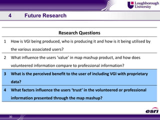
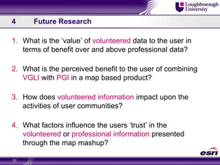

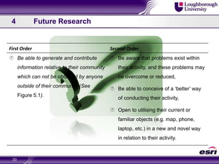
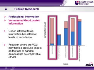


The document explores the concept of Volunteered Geographic Information (VGI), which involves untrained individuals creating geographic data. It emphasizes the importance of researching human factors to improve the usability of VGI products and discusses the relationships and perceptions of different stakeholders, including consumers and professionals. Future research aims to assess the added value of combining volunteered and professional geographic information for enhanced user benefits.


