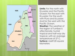
TUMBES
Limits: For the north with
Ecuador and the Pacific
Ocean; For the east with
Ecuador; For the south
with Piura and Ecuador;
And for the west with the
Pacific Ocean.
Weather: The weather of
the region of Tumbes is
affectionate, humid
tropical and half-way dry
tropical, with an average
temperature of 27 C.
Surface: 4.669,20 square
kilometers
HISTORY OF TUMBES
The region where
today the department
of Tumbes is
challenged, in preInca times was
inhabited by big
ethnos of farmers,
hunters and
merchants.
CLEAR-CUT FOODS DE TUMBES

THE MAJARISCO
TUMBESINO

THE RICE WITH
SEAFOOD

CEBICHE OF
BLACK SHELLS
CLEAR-CUT DRINKS DE TUMBES

Little clearing of
jora

King prawns
cocktail
The chinguirito
FESTIVE CALENDAR OF TUMBES

January

February
March – April

July
August
September
October
December

May
June
ATTRACTIVE HOLIDAY RESORTS

National Sanctuary
of Mangroves of
Tumbes.

Port Pizarro
Tip Sal
Jetty Benavides
National park
of Hills of
Amotape
CRAFTSMANSHIP IN TUMBES
Music and Dances of Tumbes

The Cumananas

The dance of the bangs
THE FLORA
TUMBESINA
In this thick vegetation of
Tumbes they meet to 15
sorts of trees, such like the
Guaiacum, Palo of Vaca,
Laurel, Balsamic,
Guachapelí, black wood,
ear of Leo, etc., to
difference with the rest of
the coastal departments.
iguanas

Langoustine's

Mejillones

TUMBES