MEGI intensifies into major typhoon, eyes Northern Luzon landfall
•Download as PPT, PDF•
0 likes•249 views

weather alert

Recommended
More Related Content
Recently uploaded
Recently uploaded (20)
Featured
Featured (20)
MEGI intensifies into major typhoon, eyes Northern Luzon landfall
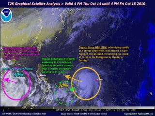
- 3. ANALYSIS & FORECAST OUTLOOK (up to 48 hours) * MEGI's circulation has become better organized and is now developing an eyewall as confirmed on the aircraft recon report. The storm is expected to become a Category 1 typhoon tonight and will continue tracking WNW-ward into the Philippine Sea [2AM OCT 15: 13.5N 137.8E @ 120kph...2PM OCT 15: 14.5N 136.2E @ 140kph]. It will then enter the Philippine Area of Responsibility (PAR) tomorrow evening (Friday) and intensify further into a Category 2 typhoon [2AM OCT 16: 15.5N 134.3E @ 175kph] . By Saturday afternoon, MEGI will be moving into the central portion of the Philippine Sea - as a Major Typhoon (Category 3) with winds of almost 200 km/hr [2PM OCT 16: 16.4N 132.1E @ 195kph] . Maximum Sustained Winds (1-min. avg) are now near 110 km/hr (60 knots) with higher gusts. MEGI will continue to intensify through Saturday. Tropical Storm Force Winds (62-117 km/hr) extend outward up to 100 kilometers (55 nautical miles) from the center. MEGI is an average-sized tropical cyclone with a diameter of 445 kilometers (240 nautical miles) across.
- 4. EXTENDED FORECAST TRACK (3 to 5 days) * SUNDAY AFTERNOON: Bending more towards the west...upgraded to Category 4, eyeing Northern Luzon [2PM OCT 17: 17.3N 127.6E @ 215kph] . MONDAY AFTERNOON: At near Super Typhoon strength (220 km/hr)... approaching the coast of Eastern Cagayan-Isabela-Northern Aurora Area...Storm Surge (Big Waves) lashing the eastern coast of Luzon [2PM OCT 18: 17.3N 123.5E @ 220kph] . TUESDAY AFTERNOON: Off the coast of La Union-Lingayen Area after crossing Northern Luzon...moving WSW towards the South China Sea...downgraded to Category 2 [2PM OCT 19: 16.8N 119.6E @ 175kph] .