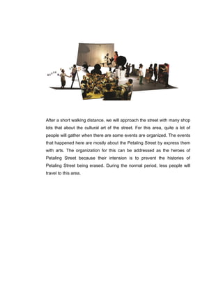
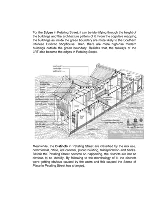
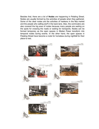
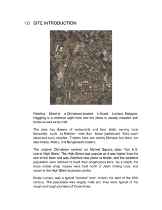
1.0 SITE INTRODUCTION
Petaling Street is a Chinatown located in Kuala Lumpur, Malaysia.
Haggling is a common sight here and the place is usually crowded with
locals as well as tourists.
The area has dozens of restaurants and food stalls, serving local
favourites such as Hokkien mee, ikan bakar (barbecued fish), asam
laksa and curry noodles. Traders here are mainly Chinese but there are
also Indian, Malay, and Bangladeshi traders.
The original Chinatown centred on Market Square. Jalan Tun H.S.
Lee or High Street. The High Street was popular as it was higher than the
rest of the town and was therefore less prone to floods, and the wealthier
population were inclined to build their shophouses here. As a result, the
more ornate shop houses were built north of Jalan Cheng Lock, and
closer to the High Street business centre.
Kuala Lumpur was a typical "pioneer" town around the start of the 20th
century. The population was largely male and they were typical of the
rough and tough pioneers of those times.
The men were mainly Cantonese and Hakkas who had come to the city
because of the tin trade, working as coolies in the mines. They were
governed by a Chinese Kapitan or headman. The most famous
Chinese Kapitan was Yap Ah Loy
In 1870, civil war erupted within the Chinese community. This was split
along partisan lines between the Hokkien Ghee Hin and the Hakka Hai
San secret societies. The British realizing that the war is disrupting their
economy and chain of supply, decided to enter the war. As a result of the
long civil war, many buildings were destroyed or severely damaged.[2]
During this Selangor Civil War, the tin mines were abandoned. The
neglect during this time caused them to become flooded. When the war
was over, and when the miners returned after the war, they found that the
mines were now unworkable due to flooding. Yap Ah Loy managed to
persuade the miners and coolies to remain in KL and also persuaded the
Malays in surrounding districts to grow rice and other garden products. He
opened a Tapioca Mill in Petaling Street where the tubers from his farms
were brought to be ground into flour. Petaling Street is fondly called ‘Chee
Cheong Kai’ in Cantonese which means Starch Factory Street.
2.0 COGNITIVE MAPPING
3.0 ANALYSIS BASED ON COGNITIVE MAPPING
To have a visit to Petaling Street, it is very convenience to approach the
site because there are many public transports that can be surround it. To
analyses the site, a walk through by feet around the site was applied. As
approached to the site by one of the public transport from the Pasar Seni
LRT station, a significant visual contrast is the form in between the
high-rise buildings and the repetition architecture form in the Petaling
Street. In Petaling Street, there are many historical old shop lots and
building. But, as the construction site that shown in the cognitive mapping,
it tells that a huge area of buildings has been bulldozed to build something
there.
After a short walking distance, we will approach the street with many shop
lots that about the cultural art of the street. For this area, quite a lot of
people will gather when there are some events are organized. The events
that happened here are mostly about the Petaling Street by express them
with arts. The organization for this can be addressed as the heroes of
Petaling Street because their intension is to prevent the histories of
Petaling Street being erased. During the normal period, less people will
travel to this area.
By continuing the journey, the famous street, Jalan Sultan can be reached.
Jalan Sultan has two entrance to go to the Petaling Street Flea Market.
Before visit to the market, there are two famous temples which are the
Hindu temple and the Guan Ti Chinese temple. The Hindu temple is the
oldest temple in Kuala Lumpur and it is very crowded during the operation
hour as well as the Guan Ti Chinese temple is vert attracting too. Because
of these two temples, they make the hawkers have opportunities for
business. For this area, there is also another entrance(west) to go to the
flea market.
After that, by walk along the Jalan Sultan from west to the east side, many
Chinese restaurants(Kopitiam) can be found and the food hawker stalls as
well. By comparing to the morning and night, there are more people and
shop will open during the night to midnight session. The west side of Jalan
Sultan is a food heaven because this street is already famous with
delicious foods since years ago.
Nowadays, Petaling Street become so famous because of its flea market,
the flea market is the typical of South East Asian flea market. Inside there
is very crowded with fake designer products. The market is very messy
and uncomfortable for people who just interested to see around. But for
people who wanted to come visit, eat or shopping, here will be their
heaven. The flea market is always crowded during the day and night.
During the night time, more hawker stalls will be opened by comparing to
the day time. Tourists, students, families, hawkers can be seen here.
There is another open-air market which near to the Central Market- The
Kasturi Walk which located beside the river at the North side of the
Petaling Street. For this street, there are more Malay hawkers then more
halal foods are selling here. This crowd of this market is not losing to the
Petaling Flea Market too. For this market, more genuine souvenir are
selling by comparing to the other market.
Because of the growing of the crowd of Petaling Street, many homeless
people took the opportunity to earn their livings in this area. And this has
become the negative impression of Petaling Street. Homeless people had
been threatened as crime more than people who lose their home.
For the overall result, most of the people will come to Petaling Street most
of the time. I think the most attracting part of Petaling Street is the
multicultural and religion of Malaysia.
4.0 Analysis based on Kevin Lynch Theories – The
Imageability of a City
Kevin Lynch’s main argument on the physical imageability of a city are
mainly based on five elements:
Path : The streets, sidewalks, trails and other channels in which
people travel.
Edges : Perceived boundaries such as walls, buildings and
shorelines.
Districts : Relatively large sections of the city distinguished by some
identity or character.
Nodes : Focal points, intersections of paths such as public square
or junction.
Landmarks : Readily identifiable objects which serve as external
reference points.
As relate back to Kevin Lynch’s theories, the Path in the Petaling Street
can be easily identify by the vehicular path to the pedestrian path because
many public transport can be taken to there. For example, by using the
LDR, public bus or taxis. Besides that, the privatization of the back lane
also been used, this is caused by the hawker stalls that held in the back
lane then attracted people. Then, service that happened on the main
street due to closure of back lane and path used by students also can be
identify clearly.
For the Edges in Petaling Street, it can be identifying through the height of
the buildings and the architecture pattern of it. From the cognitive mapping,
the buildings as inside the green boundary are more likely to the Southern
Chinese Eclectic Shophouse. Then, there are more high-rise modern
buildings outside the green boundary. Besides that, the railways of the
LRT also become the edges in Petaling Street.
Meanwhile, the Districts in Petaling Street are classified by the mix use,
commercial, office, educational, public building, transportation and banks.
Before the Petaling Street become so happening, the districts are not so
obvious to be identify. By following to the morphology of it, the districts
were getting obvious caused by the users and this caused the Sense of
Place in Petaling Street has changed.
Besides that, there are a lot of Nodes are happening in Petaling Street.
Nodes are usually formed by the activities of people when they gathered.
Some of the clear nodes are the activities of hawkers in the flea market
and the people who selling stuff in the back lane. Also, the commuters are
also covered the big area of nodes because many people are waiting on
the spots for crossing the roads or waiting for transports. Nodes can be
formed temporary as the open spaces in Medan Pasar transform into
temporal nodes during events. In the other hand, the open spaces in
Petaling Street have become a node for homeless during nightfall for their
place to rest.
Moreover, the Landmark can be separated into two categories which is
can be classified by local or international. Those landmark in Petaling
Street that can be identify by local are the kite(Wau) in the entrance of the
Kasturi walk, the central market, the Sri Maha Mariaman Hindu Temple,
Public Bank, Petaling Street Gateway(Flea market entrance) and the
Chinese temples. For international, most of the landmark are about the
brand visual for example the 7-Eleven or fast food branches. The
landmarks are used to recognize the direction or location in the area.
5.0 Comparison between Petaling Street and Mt. Auburn
Street.
To compare The Petaling Street and Mt. Auburn street, it will be difficult if
our own didn’t experience the site by ourselves. From the map of Mt.
Auburn Street, the street that walked by users are normally the Path of the
site and the back lane between those buildings are basically used as drop
of pick up point for goods, or ventilation purpose. The Edges are hardly
seen in Cambridge because most of the buildings are in the same height
and in the Italianate architecture style. For the Districts in Cambridge, it
can be identified by two different area which is the market place and the
educational zone. In this street, most of the people are creating the Nodes
by through some events or gathering in the park. It is quite easy to
recognize the direction when you are in the Mt. Auburn Street because
there are different interesting Landmark in different zone of the site. For
some of the great example of there are the Schoenhof’s foreign books, a
building which covered by grass façade, The Harvard Lampoon Building
which located in the middle of the street and the Harvard Square, a place
where many people always gather, it is a node for the street as well.
6.0 Conclusion
For the overall conclusion, to know a street or an area well, the Kevin
Lynch’s theories are the good solution to understand the site. Of course,
there may have other solution to identify the site, but at least by using this
solution can help us as the first step to start our journey. When we used to
do the identification for the street, we will easily know the morphology to
the urban area. This is one of the important for the architecture because
everything would not stay longer and everything are keep changing. As
you can see from the map of the Petaling Street, the construction is
already happened and the historical buildings may vanished soon but not
from our knowledge.
SCHOOL OF ARCHITECTURE, BUILDING AND DESIGN
Bachelor of Science (Honors) in Architecture
THEORIES OF ARCHITECTURE AND URBANISM
ARC2224/ARC61303
PROJECT PART B
NAME: Wee Boon Bing
STUDENT I.D: 0313569
LECTURER: Nicholas Ng

Theories final

  • 1.
    1.0 SITE INTRODUCTION PetalingStreet is a Chinatown located in Kuala Lumpur, Malaysia. Haggling is a common sight here and the place is usually crowded with locals as well as tourists. The area has dozens of restaurants and food stalls, serving local favourites such as Hokkien mee, ikan bakar (barbecued fish), asam laksa and curry noodles. Traders here are mainly Chinese but there are also Indian, Malay, and Bangladeshi traders. The original Chinatown centred on Market Square. Jalan Tun H.S. Lee or High Street. The High Street was popular as it was higher than the rest of the town and was therefore less prone to floods, and the wealthier population were inclined to build their shophouses here. As a result, the more ornate shop houses were built north of Jalan Cheng Lock, and closer to the High Street business centre. Kuala Lumpur was a typical "pioneer" town around the start of the 20th century. The population was largely male and they were typical of the rough and tough pioneers of those times.
  • 2.
    The men weremainly Cantonese and Hakkas who had come to the city because of the tin trade, working as coolies in the mines. They were governed by a Chinese Kapitan or headman. The most famous Chinese Kapitan was Yap Ah Loy In 1870, civil war erupted within the Chinese community. This was split along partisan lines between the Hokkien Ghee Hin and the Hakka Hai San secret societies. The British realizing that the war is disrupting their economy and chain of supply, decided to enter the war. As a result of the long civil war, many buildings were destroyed or severely damaged.[2] During this Selangor Civil War, the tin mines were abandoned. The neglect during this time caused them to become flooded. When the war was over, and when the miners returned after the war, they found that the mines were now unworkable due to flooding. Yap Ah Loy managed to persuade the miners and coolies to remain in KL and also persuaded the Malays in surrounding districts to grow rice and other garden products. He opened a Tapioca Mill in Petaling Street where the tubers from his farms were brought to be ground into flour. Petaling Street is fondly called ‘Chee Cheong Kai’ in Cantonese which means Starch Factory Street.
  • 3.
    2.0 COGNITIVE MAPPING 3.0ANALYSIS BASED ON COGNITIVE MAPPING To have a visit to Petaling Street, it is very convenience to approach the site because there are many public transports that can be surround it. To analyses the site, a walk through by feet around the site was applied. As approached to the site by one of the public transport from the Pasar Seni LRT station, a significant visual contrast is the form in between the high-rise buildings and the repetition architecture form in the Petaling Street. In Petaling Street, there are many historical old shop lots and building. But, as the construction site that shown in the cognitive mapping, it tells that a huge area of buildings has been bulldozed to build something there.
  • 4.
    After a shortwalking distance, we will approach the street with many shop lots that about the cultural art of the street. For this area, quite a lot of people will gather when there are some events are organized. The events that happened here are mostly about the Petaling Street by express them with arts. The organization for this can be addressed as the heroes of Petaling Street because their intension is to prevent the histories of Petaling Street being erased. During the normal period, less people will travel to this area.
  • 5.
    By continuing thejourney, the famous street, Jalan Sultan can be reached. Jalan Sultan has two entrance to go to the Petaling Street Flea Market. Before visit to the market, there are two famous temples which are the Hindu temple and the Guan Ti Chinese temple. The Hindu temple is the oldest temple in Kuala Lumpur and it is very crowded during the operation hour as well as the Guan Ti Chinese temple is vert attracting too. Because of these two temples, they make the hawkers have opportunities for business. For this area, there is also another entrance(west) to go to the flea market. After that, by walk along the Jalan Sultan from west to the east side, many Chinese restaurants(Kopitiam) can be found and the food hawker stalls as well. By comparing to the morning and night, there are more people and shop will open during the night to midnight session. The west side of Jalan
  • 6.
    Sultan is afood heaven because this street is already famous with delicious foods since years ago. Nowadays, Petaling Street become so famous because of its flea market, the flea market is the typical of South East Asian flea market. Inside there is very crowded with fake designer products. The market is very messy and uncomfortable for people who just interested to see around. But for people who wanted to come visit, eat or shopping, here will be their heaven. The flea market is always crowded during the day and night. During the night time, more hawker stalls will be opened by comparing to the day time. Tourists, students, families, hawkers can be seen here. There is another open-air market which near to the Central Market- The Kasturi Walk which located beside the river at the North side of the Petaling Street. For this street, there are more Malay hawkers then more halal foods are selling here. This crowd of this market is not losing to the Petaling Flea Market too. For this market, more genuine souvenir are selling by comparing to the other market. Because of the growing of the crowd of Petaling Street, many homeless people took the opportunity to earn their livings in this area. And this has become the negative impression of Petaling Street. Homeless people had been threatened as crime more than people who lose their home. For the overall result, most of the people will come to Petaling Street most of the time. I think the most attracting part of Petaling Street is the multicultural and religion of Malaysia.
  • 7.
    4.0 Analysis basedon Kevin Lynch Theories – The Imageability of a City Kevin Lynch’s main argument on the physical imageability of a city are mainly based on five elements: Path : The streets, sidewalks, trails and other channels in which people travel. Edges : Perceived boundaries such as walls, buildings and shorelines. Districts : Relatively large sections of the city distinguished by some identity or character. Nodes : Focal points, intersections of paths such as public square or junction. Landmarks : Readily identifiable objects which serve as external reference points. As relate back to Kevin Lynch’s theories, the Path in the Petaling Street can be easily identify by the vehicular path to the pedestrian path because many public transport can be taken to there. For example, by using the LDR, public bus or taxis. Besides that, the privatization of the back lane also been used, this is caused by the hawker stalls that held in the back lane then attracted people. Then, service that happened on the main street due to closure of back lane and path used by students also can be identify clearly.
  • 8.
    For the Edgesin Petaling Street, it can be identifying through the height of the buildings and the architecture pattern of it. From the cognitive mapping, the buildings as inside the green boundary are more likely to the Southern Chinese Eclectic Shophouse. Then, there are more high-rise modern buildings outside the green boundary. Besides that, the railways of the LRT also become the edges in Petaling Street. Meanwhile, the Districts in Petaling Street are classified by the mix use, commercial, office, educational, public building, transportation and banks. Before the Petaling Street become so happening, the districts are not so obvious to be identify. By following to the morphology of it, the districts were getting obvious caused by the users and this caused the Sense of Place in Petaling Street has changed.
  • 9.
    Besides that, thereare a lot of Nodes are happening in Petaling Street. Nodes are usually formed by the activities of people when they gathered. Some of the clear nodes are the activities of hawkers in the flea market and the people who selling stuff in the back lane. Also, the commuters are also covered the big area of nodes because many people are waiting on the spots for crossing the roads or waiting for transports. Nodes can be formed temporary as the open spaces in Medan Pasar transform into temporal nodes during events. In the other hand, the open spaces in Petaling Street have become a node for homeless during nightfall for their place to rest.
  • 10.
    Moreover, the Landmarkcan be separated into two categories which is can be classified by local or international. Those landmark in Petaling Street that can be identify by local are the kite(Wau) in the entrance of the Kasturi walk, the central market, the Sri Maha Mariaman Hindu Temple, Public Bank, Petaling Street Gateway(Flea market entrance) and the Chinese temples. For international, most of the landmark are about the brand visual for example the 7-Eleven or fast food branches. The landmarks are used to recognize the direction or location in the area. 5.0 Comparison between Petaling Street and Mt. Auburn Street. To compare The Petaling Street and Mt. Auburn street, it will be difficult if our own didn’t experience the site by ourselves. From the map of Mt. Auburn Street, the street that walked by users are normally the Path of the site and the back lane between those buildings are basically used as drop of pick up point for goods, or ventilation purpose. The Edges are hardly seen in Cambridge because most of the buildings are in the same height and in the Italianate architecture style. For the Districts in Cambridge, it can be identified by two different area which is the market place and the educational zone. In this street, most of the people are creating the Nodes by through some events or gathering in the park. It is quite easy to recognize the direction when you are in the Mt. Auburn Street because there are different interesting Landmark in different zone of the site. For some of the great example of there are the Schoenhof’s foreign books, a building which covered by grass façade, The Harvard Lampoon Building which located in the middle of the street and the Harvard Square, a place where many people always gather, it is a node for the street as well. 6.0 Conclusion For the overall conclusion, to know a street or an area well, the Kevin Lynch’s theories are the good solution to understand the site. Of course, there may have other solution to identify the site, but at least by using this solution can help us as the first step to start our journey. When we used to do the identification for the street, we will easily know the morphology to the urban area. This is one of the important for the architecture because everything would not stay longer and everything are keep changing. As you can see from the map of the Petaling Street, the construction is already happened and the historical buildings may vanished soon but not from our knowledge.
  • 11.
    SCHOOL OF ARCHITECTURE,BUILDING AND DESIGN Bachelor of Science (Honors) in Architecture THEORIES OF ARCHITECTURE AND URBANISM ARC2224/ARC61303 PROJECT PART B NAME: Wee Boon Bing STUDENT I.D: 0313569 LECTURER: Nicholas Ng