1. The document describes an innovative technology for remote sensing of the Earth using satellite imagery. Infrared signals containing information about mineral structures are captured in analog satellite images and then processed.
2. Test wafers containing mineral samples are used as resonators to filter the infrared signals from the satellite images. The detected objects are then visualized and their contours transferred onto maps.
3. Key steps include radiation-chemical processing of the images around the test wafers, chemical processing of exposed x-ray film to develop the detected objects, and using high-tension pulses to visualize and map the contours. Analytic data is then processed to characterize the detected deposits.
3. Analytic data processing
Obtainment of deposit parameters: - coordinates of ground contours of the detected deposits, - number of horizons, - occurrence depths of horizons and their thickness, - reservoir rocks, - inundation of horizons - presence of gas caps and pressure in them.
4. Preparation and submission of report to the Customer Location map making, contouring of deposits, calculation of expected reserves of hydrocarbons, preparation of explanatory part of the report.
Application of Seismic Reflection Surveys to Detect Massive Sulphide Deposits...iosrjce
Seismic reflection techniques, the most widely used geophysical method for hydrocarbon exploration
has the capability to delineate and provide better images of regional structure for exploration of mineral
deposits in any geological settings. Previous tests on detection and imaging of massive sulphide ores using
seismic reflection techniques have been done mostly in crystalline environments. Application of seismic
reflection techniques for imaging sedimentary hosted massive sulphide is relatively new and the few experiments
carried out are at local scale (<500m). In this study, we analyze the feasibility of such regional exploration by
modelling three massive sulphide ore and norite lenses scenario using 2D seismic survey with relatively sparse
source-receiver geometry to image these deposits within 1.5km depth range. Results from the modelling
experiment demonstrate that 2-Dimensional seismic reflections survey can be used to detect massive sulphides
at any scale. The test further indicates that geologic setting and acquisition parameters are very important for
the detection of these ore bodies. Overall, the outcomes of the results support our started objective which is to
demonstrate that seismic reflection surveys can be used to detect the presence of sediment hosted massive
sulphides at regional scale
APPLICATION OF SIGNAL PROCESSING IN RADIO ASTRONOMY SYSTEMSSaumya Tiwari
We discuss pulsar detection and timing pulsar profiling. We also consider image formation and radio maps cleaning using the CLEAN algorithm. Finally, we briefly discuss some future radio telescopes, which will consist of distributed phased arrays with a large number of elements.
This content presents for basic of Synthetic Aperture Radar (SAR) including its geometry, how the image is created, essential parameters, interpretation, SAR sensor specification, and advantages and disadvantages.
International Journal of Engineering Research and Applications (IJERA) is an open access online peer reviewed international journal that publishes research and review articles in the fields of Computer Science, Neural Networks, Electrical Engineering, Software Engineering, Information Technology, Mechanical Engineering, Chemical Engineering, Plastic Engineering, Food Technology, Textile Engineering, Nano Technology & science, Power Electronics, Electronics & Communication Engineering, Computational mathematics, Image processing, Civil Engineering, Structural Engineering, Environmental Engineering, VLSI Testing & Low Power VLSI Design etc.
ESA SMOS (Soil Moisture and Ocean Salinity) Mission: Principles of Operation ...adrianocamps
SMOS basic principles and description of some products developed at the SMOS Barcelona Expert Center.
Disclaimer: these materials were prepared for Eduacational purposes only.
DUAL BAND GNSS ANTENNA PHASE CENTER CHARACTERIZATION FOR AUTOMOTIVE APPLICATIONSjantjournal
High-accuracy Global Navigation Satellite System (GNSS) positioning is a prospective technology that will be used in future automotive navigation systems. This system will be a composite of the United States' Global Positioning System (GPS), the Russian Federation's Global Orbiting Navigation Satellite System (GLONASS), China Beidou Navigation Satellite System (BDS) and the European Union’s Galileo. The major improvement in accuracy and precision is based on (1) multiband signal transmitting, (2) carrier phase correction, (3) Real Time Kinematic (RTK). Due to the size and high-cost of today’s survey-grade antenna solutions, this kind of technology is difficult to use widely in the automotive sector. In this paper, a low-cost small size dual-band ceramic GNSS patch antenna is presented from design to real sample. A further study of this patch antenna illustrates the absolute phase center variation measured in an indoor range to achieve a received signal phase error correction. In addition, this low-cost antenna solution is investigated when integrated into a standard multi-band automotive antenna product. This product is evaluated both on its own in an indoor range and on a typical vehicle roof at an outdoor range. By using this evaluation file to estimate the receiver position could achieve phase motion error-free result.
DUAL BAND GNSS ANTENNA PHASE CENTER CHARACTERIZATION FOR AUTOMOTIVE APPLICATIONSjantjournal
High-accuracy Global Navigation Satellite System (GNSS) positioning is a prospective technology that will
be used in future automotive navigation systems. This system will be a composite of the United States'
Global Positioning System (GPS), the Russian Federation's Global Orbiting Navigation Satellite System
(GLONASS), China Beidou Navigation Satellite System (BDS) and the European Union’s Galileo. The
major improvement in accuracy and precision is based on (1) multiband signal transmitting, (2) carrier
phase correction, (3) Real Time Kinematic (RTK). Due to the size and high-cost of today’s survey-grade
antenna solutions, this kind of technology is difficult to use widely in the automotive sector. In this paper, a
low-cost small size dual-band ceramic GNSS patch antenna is presented from design to real sample. A
further study of this patch antenna illustrates the absolute phase center variation measured in an indoor
range to achieve a received signal phase error correction. In addition, this low-cost antenna solution is
investigated when integrated into a standard multi-band automotive antenna product. This product is
evaluated both on its own in an indoor range and on a typical vehicle roof at an outdoor range. By using
this evaluation file to estimate the receiver position could achieve phase motion error-free result.
Presentation made by Prof. Adriano Camps (Universitat Politècnica de Catalunya) at ICMARS 2010 (India, 16-December-2010) on the MIRAS instrument aboard ESA's SMOS mission.
APPLICATION OF REMOTE SENSING AND GIS IN AGRICULTURELagnajeetRoy
India is a country that depends on agriculture. Today in this era of technological supremacy, agriculture is also using different new technologies like some robotic machinery to remote sensing and Geographical Information System (GIS) for the betterment of agriculture. It is easy to get the information about that area where human cannot check the condition everyday and help in gathering the data with the help of remote sensing. Whereas GIS helps in preparation of map that shows an accurate representation of data we get through remote sensing. From disease estimation to stress factor due to water, from ground water quality index to acreage estimation in various way agriculture is being profited by the application of remote sensing and GIS in agriculture. The applications of those software or techniques are very new to the agriculture domain still much more exploration is needed in this part. New software’s are developing in different parts of the world and remote sensing. Today farmers understand the beneficiaries of these kinds of techniques to the farm field which help in increasing productivity that will help future generation as technology is hype in traditional system of farming.
UiPath Test Automation using UiPath Test Suite series, part 4DianaGray10
Welcome to UiPath Test Automation using UiPath Test Suite series part 4. In this session, we will cover Test Manager overview along with SAP heatmap.
The UiPath Test Manager overview with SAP heatmap webinar offers a concise yet comprehensive exploration of the role of a Test Manager within SAP environments, coupled with the utilization of heatmaps for effective testing strategies.
Participants will gain insights into the responsibilities, challenges, and best practices associated with test management in SAP projects. Additionally, the webinar delves into the significance of heatmaps as a visual aid for identifying testing priorities, areas of risk, and resource allocation within SAP landscapes. Through this session, attendees can expect to enhance their understanding of test management principles while learning practical approaches to optimize testing processes in SAP environments using heatmap visualization techniques
What will you get from this session?
1. Insights into SAP testing best practices
2. Heatmap utilization for testing
3. Optimization of testing processes
4. Demo
Topics covered:
Execution from the test manager
Orchestrator execution result
Defect reporting
SAP heatmap example with demo
Speaker:
Deepak Rai, Automation Practice Lead, Boundaryless Group and UiPath MVP
GraphRAG is All You need? LLM & Knowledge GraphGuy Korland
Guy Korland, CEO and Co-founder of FalkorDB, will review two articles on the integration of language models with knowledge graphs.
1. Unifying Large Language Models and Knowledge Graphs: A Roadmap.
https://arxiv.org/abs/2306.08302
2. Microsoft Research's GraphRAG paper and a review paper on various uses of knowledge graphs:
https://www.microsoft.com/en-us/research/blog/graphrag-unlocking-llm-discovery-on-narrative-private-data/
Software Delivery At the Speed of AI: Inflectra Invests In AI-Powered QualityInflectra
In this insightful webinar, Inflectra explores how artificial intelligence (AI) is transforming software development and testing. Discover how AI-powered tools are revolutionizing every stage of the software development lifecycle (SDLC), from design and prototyping to testing, deployment, and monitoring.
Learn about:
• The Future of Testing: How AI is shifting testing towards verification, analysis, and higher-level skills, while reducing repetitive tasks.
• Test Automation: How AI-powered test case generation, optimization, and self-healing tests are making testing more efficient and effective.
• Visual Testing: Explore the emerging capabilities of AI in visual testing and how it's set to revolutionize UI verification.
• Inflectra's AI Solutions: See demonstrations of Inflectra's cutting-edge AI tools like the ChatGPT plugin and Azure Open AI platform, designed to streamline your testing process.
Whether you're a developer, tester, or QA professional, this webinar will give you valuable insights into how AI is shaping the future of software delivery.
Elevating Tactical DDD Patterns Through Object CalisthenicsDorra BARTAGUIZ
After immersing yourself in the blue book and its red counterpart, attending DDD-focused conferences, and applying tactical patterns, you're left with a crucial question: How do I ensure my design is effective? Tactical patterns within Domain-Driven Design (DDD) serve as guiding principles for creating clear and manageable domain models. However, achieving success with these patterns requires additional guidance. Interestingly, we've observed that a set of constraints initially designed for training purposes remarkably aligns with effective pattern implementation, offering a more ‘mechanical’ approach. Let's explore together how Object Calisthenics can elevate the design of your tactical DDD patterns, offering concrete help for those venturing into DDD for the first time!
Generating a custom Ruby SDK for your web service or Rails API using Smithyg2nightmarescribd
Have you ever wanted a Ruby client API to communicate with your web service? Smithy is a protocol-agnostic language for defining services and SDKs. Smithy Ruby is an implementation of Smithy that generates a Ruby SDK using a Smithy model. In this talk, we will explore Smithy and Smithy Ruby to learn how to generate custom feature-rich SDKs that can communicate with any web service, such as a Rails JSON API.
Essentials of Automations: Optimizing FME Workflows with ParametersSafe Software
Are you looking to streamline your workflows and boost your projects’ efficiency? Do you find yourself searching for ways to add flexibility and control over your FME workflows? If so, you’re in the right place.
Join us for an insightful dive into the world of FME parameters, a critical element in optimizing workflow efficiency. This webinar marks the beginning of our three-part “Essentials of Automation” series. This first webinar is designed to equip you with the knowledge and skills to utilize parameters effectively: enhancing the flexibility, maintainability, and user control of your FME projects.
Here’s what you’ll gain:
- Essentials of FME Parameters: Understand the pivotal role of parameters, including Reader/Writer, Transformer, User, and FME Flow categories. Discover how they are the key to unlocking automation and optimization within your workflows.
- Practical Applications in FME Form: Delve into key user parameter types including choice, connections, and file URLs. Allow users to control how a workflow runs, making your workflows more reusable. Learn to import values and deliver the best user experience for your workflows while enhancing accuracy.
- Optimization Strategies in FME Flow: Explore the creation and strategic deployment of parameters in FME Flow, including the use of deployment and geometry parameters, to maximize workflow efficiency.
- Pro Tips for Success: Gain insights on parameterizing connections and leveraging new features like Conditional Visibility for clarity and simplicity.
We’ll wrap up with a glimpse into future webinars, followed by a Q&A session to address your specific questions surrounding this topic.
Don’t miss this opportunity to elevate your FME expertise and drive your projects to new heights of efficiency.
DevOps and Testing slides at DASA ConnectKari Kakkonen
My and Rik Marselis slides at 30.5.2024 DASA Connect conference. We discuss about what is testing, then what is agile testing and finally what is Testing in DevOps. Finally we had lovely workshop with the participants trying to find out different ways to think about quality and testing in different parts of the DevOps infinity loop.
State of ICS and IoT Cyber Threat Landscape Report 2024 previewPrayukth K V
The IoT and OT threat landscape report has been prepared by the Threat Research Team at Sectrio using data from Sectrio, cyber threat intelligence farming facilities spread across over 85 cities around the world. In addition, Sectrio also runs AI-based advanced threat and payload engagement facilities that serve as sinks to attract and engage sophisticated threat actors, and newer malware including new variants and latent threats that are at an earlier stage of development.
The latest edition of the OT/ICS and IoT security Threat Landscape Report 2024 also covers:
State of global ICS asset and network exposure
Sectoral targets and attacks as well as the cost of ransom
Global APT activity, AI usage, actor and tactic profiles, and implications
Rise in volumes of AI-powered cyberattacks
Major cyber events in 2024
Malware and malicious payload trends
Cyberattack types and targets
Vulnerability exploit attempts on CVEs
Attacks on counties – USA
Expansion of bot farms – how, where, and why
In-depth analysis of the cyber threat landscape across North America, South America, Europe, APAC, and the Middle East
Why are attacks on smart factories rising?
Cyber risk predictions
Axis of attacks – Europe
Systemic attacks in the Middle East
Download the full report from here:
https://sectrio.com/resources/ot-threat-landscape-reports/sectrio-releases-ot-ics-and-iot-security-threat-landscape-report-2024/
Kubernetes & AI - Beauty and the Beast !?! @KCD Istanbul 2024Tobias Schneck
As AI technology is pushing into IT I was wondering myself, as an “infrastructure container kubernetes guy”, how get this fancy AI technology get managed from an infrastructure operational view? Is it possible to apply our lovely cloud native principals as well? What benefit’s both technologies could bring to each other?
Let me take this questions and provide you a short journey through existing deployment models and use cases for AI software. On practical examples, we discuss what cloud/on-premise strategy we may need for applying it to our own infrastructure to get it to work from an enterprise perspective. I want to give an overview about infrastructure requirements and technologies, what could be beneficial or limiting your AI use cases in an enterprise environment. An interactive Demo will give you some insides, what approaches I got already working for real.
Smart TV Buyer Insights Survey 2024 by 91mobiles.pdf91mobiles
91mobiles recently conducted a Smart TV Buyer Insights Survey in which we asked over 3,000 respondents about the TV they own, aspects they look at on a new TV, and their TV buying preferences.
Connector Corner: Automate dynamic content and events by pushing a buttonDianaGray10
Here is something new! In our next Connector Corner webinar, we will demonstrate how you can use a single workflow to:
Create a campaign using Mailchimp with merge tags/fields
Send an interactive Slack channel message (using buttons)
Have the message received by managers and peers along with a test email for review
But there’s more:
In a second workflow supporting the same use case, you’ll see:
Your campaign sent to target colleagues for approval
If the “Approve” button is clicked, a Jira/Zendesk ticket is created for the marketing design team
But—if the “Reject” button is pushed, colleagues will be alerted via Slack message
Join us to learn more about this new, human-in-the-loop capability, brought to you by Integration Service connectors.
And...
Speakers:
Akshay Agnihotri, Product Manager
Charlie Greenberg, Host
1. 1
Fig. 2
О
T
pt
he
icreq
al
F
i
u
i
r
l
t
e
r
e
d
s
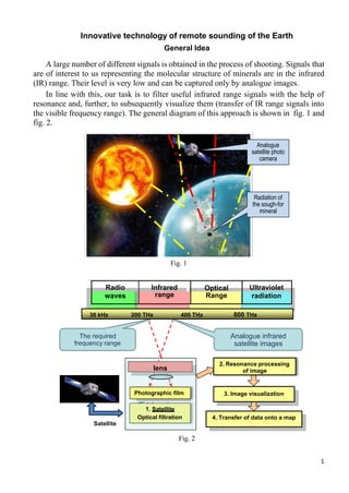
Innovative technology of remote sounding of the Earth
General Idea
A large number of different signals is obtained in the process of shooting. Signals that
are of interest to us representing the molecular structure of minerals are in the infrared
(IR) range. Their level is very low and can be captured only by analogue images.
In line with this, our task is to filter useful infrared range signals with the help of
resonance and, further, to subsequently visualize them (transfer of IR range signals into
the visible frequency range). The general diagram of this approach is shown in fig. 1 and
fig. 2.
Fig. 1
Radio
waves
Infrared
range
Optical
Range
Ultraviolet
radiation
Fig. 2
Analogue
satellite photo
сamera
Radiation of
the sough-for
mineral
The required
frequency range
Analogue infrared
satellite images
Satellite
4. Transfer of data onto a map
3. Image visualization
2. Resonance processing
of image
1. Satellite
Optical filtration
Photographic film
lens
30 kHz 200 THz 400 THz 800 THz
2. 2
Sequence of Works on Remote
Survey of Areas
1. Preparatory works
Fig. 3
Fig. 4
Fig. 5
Further the test wafers are used as a resonator during radiation-chemical processing of analogue
satellite images of the territory obtained in the infrared range.
Base № 1
1.2. Laboratory manufacture
of test gel wafers
Vacuum
sputtering of gels
and reference
materials
1 N
1.1. Ordering and receiving
analog infrared satellite
imagery survey territory
Test wafer
№ 1
Test wafer
№ N
Reprinter
3. 3
2. Identification of the Sought-for Objects
2.1. Radiation-chemical processing of satellite images in the presence of test gel wafers
in accordance with the patented technology
Satellite image Test wafer X-ray film Location map
Fig. 6
2.2. Chemical processing of exposed X-ray film
2.3. Visualization of the detected objects in high-tension impulse field
High-tension impulse voltage
Visualization and
transfer of contours
of deposits onto
a map
Computer
Fig. 7
Radiation and chemical
processing of analogue
satellite images
Isotrope α + γ
radiation
Radiation and chemical processing of analogue
satellite images
Resonancе Result
Combined in a “sandwich” and placed in the IR-100 reactor zone
Visualization and
transfer of contours
of deposits onto a
map
4. 4
2.4. Detected object snap (fixation)
Outcome – direction visualization of ground contours of deposits and calculation of
occurrence depths of their horizons.
3. Analytic data processing
Obtainment of deposit parameters:
- coordinates of ground contours of the detected deposits,
- number of horizons,
- occurrence depths of horizons and their thickness,
- reservoir rocks,
- inundation of horizons
- presence of gas caps and pressure in them.
4. Preparation and submission of report to the Customer
Location map making, contouring of deposits, calculation of expected reserves of
hydrocarbons, preparation of explanatory part of the report.
Technical implementation
Contouring
Transfer contours on the map
Depth calculation
Deposit of oil
Used physical effects
Nuclear magnetic and paramagnetic resonance,
Transfer of own spectral characteristics of samples of minerals onto test wafers,
Electromagnetic object visualization.
Equipment and materials
Special chemical laboratory,
Isotrope source of α and γ radiation,
Analogue satellite images of a survey territory
in infrared range,
High-purity chemical reagents,
High-sensitivity X-ray film.