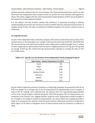
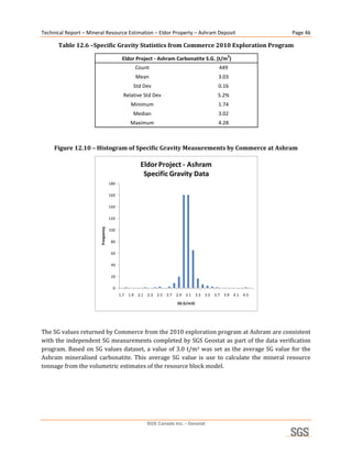
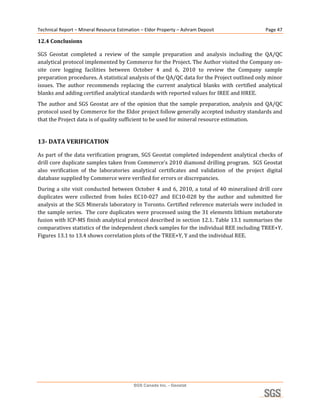
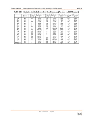
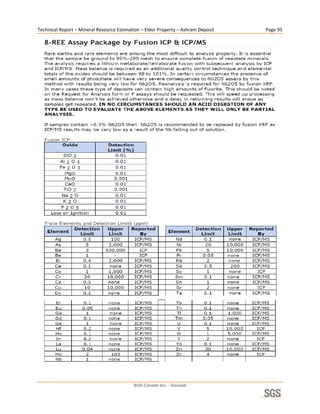
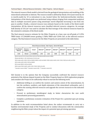
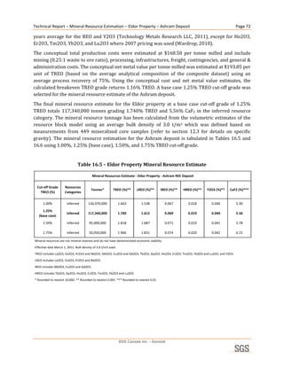
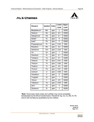
Technical Report 
                        Mineral Resource Estimation 
                      Eldor Property – Ashram Deposit 
                              Nunavik, Quebec 
                      Commerce Resources Corporation 


                                                             Respectfully submitted to: 
                                                        Commerce Resources Corporation 
                                                                                         
                                                                                     By: 
                                                           André Laferrière M.Sc. P.Geo. 
                                                              SGS Canada Inc. – Geostat 
                                                                                         
                                                                                   Date: 
                                                                         April 15, 2011 


                  Geostat
                  10 boul. de la Seigneurie Est, Suite 203, Blainville, Québec Canada
SGS Canada Inc.   t (450) 433 1050 f (450) 433 1048 www.geostat.com www.met.sgs.com

                  Member of SGS Group (SGS SA)
Technical Report – Mineral Resource Estimation – Eldor Property – Ashram Deposit                                                                       Page ii 

TABLE OF CONTENTS 

Table of Contents ............................................................................................................................ ii 
List of Tables ................................................................................................................................. iv 
List of Figures ................................................................................................................................ iv 
1- Executive Summary .....................................................................................................................6 
2- Introduction and Terms of Reference ..........................................................................................8 
  2.1 General ................................................................................................................................................ 8 
  2.2 Terms of Reference ............................................................................................................................. 8 
  2.3 Units and Currency.............................................................................................................................. 9 
  2.4 Disclaimer ......................................................................................................................................... 10 
3- Reliance on Other Experts .........................................................................................................10 
4- Property Description and Location ............................................................................................11 
  4.1 Location ............................................................................................................................................. 11 
  4.2 Property Ownership and Agreements................................................................................................ 12 
  4.3 Royalties Obligations ........................................................................................................................ 14 
  4.4 Permits and Environmental Liabilities .............................................................................................. 14 
  4.5 Mineralisation.................................................................................................................................... 14 
5- Accessibility, Physiography, Climate, Local Resources and Infrastructure..............................15 
  5.1 Accessibility ...................................................................................................................................... 15 
  5.2 Physiography ..................................................................................................................................... 15 
  5.3 Climate .............................................................................................................................................. 15 
  5.4 Local Resources and Infrastructures ................................................................................................. 16 
6- History .......................................................................................................................................16 
  6.1 Regional Government Surveys .......................................................................................................... 16 
  6.2 Mineral Exploration Work ................................................................................................................ 16 
7- Geological Setting .....................................................................................................................18 
  7.1 Regional Geology .............................................................................................................................. 18 
  7.2 Property Geology .............................................................................................................................. 21 
8- Deposit Model ...........................................................................................................................23 
9- Mineralisation ............................................................................................................................25 
10- Exploration and Drilling ..........................................................................................................26 
11- Sampling Method and Approach .............................................................................................28 
12- Sample Preparation, Analysis and Security .............................................................................30 
  12.1 Sample Preparation and Analyses ................................................................................................... 30 
  12.2 Quality Assurance and Quality Control Procedure ......................................................................... 31 
    12.2.1 Analytical Standards ................................................................................................................. 31 
    12.2.2 Analytical Blanks...................................................................................................................... 35 
    12.2.3 Drill Core Duplicates ................................................................................................................ 35 
    12.2.4 Pulp Duplicates ......................................................................................................................... 38 
    12.2.5 QA/QC Conclusion ................................................................................................................... 44 
  12.3 Specific Gravity............................................................................................................................... 45 
  12.4 Conclusions ..................................................................................................................................... 47 
13- Data Verification .....................................................................................................................47 
14- Adjacent Properties..................................................................................................................58 
15- Mineral Processing and Metallurgical Testing ........................................................................59 
16- Mineral Resource and Mineral Reserve Estimates ..................................................................60 
  16.1 Introduction ..................................................................................................................................... 60 
  16.2 Exploratory Data Analysis .............................................................................................................. 60 
    16.2.1 Analytical Data ......................................................................................................................... 60 
                                                              SGS Canada Inc. - Geostat
Technical Report – Mineral Resource Estimation – Eldor Property – Ashram Deposit                                                                Page iii 

    16.2.2 Composite Data ........................................................................................................................ 63 
    16.2.3 Specific Gravity ........................................................................................................................ 65 
  16.3 Geological Interpretation ................................................................................................................. 65 
  16.4 Spatial Analysis ............................................................................................................................... 67 
  16.5 Resource Block Modeling ............................................................................................................... 68 
  16.6 Grade Interpolation Methodology ................................................................................................... 69 
  16.7 Mineral Resource Classification ..................................................................................................... 71 
  16.8 Mineral Resource Estimation .......................................................................................................... 71 
  16.9 Mineral Resource Validation........................................................................................................... 73 
  16.10 Comments about the Mineral Resource Estimate ......................................................................... 73 
17- Other Relevant Data and Information .....................................................................................74 
18- Interpretation and Conclusions ................................................................................................74 
19- Recommendations ...................................................................................................................76 
20- References ...............................................................................................................................78 
21- Signature Page .........................................................................................................................80 
22- Certificate of Qualification ......................................................................................................81 


                                                            SGS Canada Inc. - Geostat
Technical Report – Mineral Resource Estimation – Eldor Property – Ashram Deposit                                                                      Page iv 

LIST OF TABLES 

Table 2.1 – List of Abbreviations ................................................................................................................. 9 
Table 2.2 – Conversion Factors .................................................................................................................. 10 
Table 4.1 – Summary of Mineralisation Occurring on the Eldor Property ................................................. 15 
Table 10.1 – Summary of Drilling Completed at Eldor by Commerce ...................................................... 27 
Table 12.1 – Expected Values and QA/QC Ranges of SX18-01 and SX18-05 Analytical Standards for Y,
    La, Ce, Nd and Nb2O5 .......................................................................................................................... 32 
Table 12.2 - Summary Statistics of SX18-01 and SX18-05 Analytical Standards for Y, La, Ce, Nd and
    Nb2O5 ................................................................................................................................................... 32 
Table 12.3 – Comparative Statistics for the Drill Core Duplicates............................................................. 36 
Table 12.4 –Statistics for the Pulp Duplicates (Act Labs vs. Inspectorate) ................................................ 39 
Table 12.5 –Specific Gravity Statistics from Independent Check Sampling Program ............................... 45 
Table 12.6 –Specific Gravity Statistics from Commerce 2010 Exploration Program ................................ 46 
Table 13.1 –Statistics for the Independent Check Samples (Act Labs vs. SGS Minerals) ......................... 48 
Table 13.2 –Statistics for the Independent Check Samples (Act Labs vs. ALS Chemex) .......................... 53 
Table 13.3 – Final Drill Hole Database ...................................................................................................... 58 
Table 16.1 – Summary Statistics of Analytical Data Used in the Mineral Resource Estimate................... 61 
Table 16.2 – Summary Statistics for the 3 metre Composites .................................................................... 64 
Table 16.3 – Variogram Model of TREO Grade for 3 m Composite ......................................................... 67 
Table 16.4 – Resource Block Model Parameters ........................................................................................ 69 
Table 16.5 – Eldor Property Mineral Resource Estimate ........................................................................... 72 
Table 16.6 – Eldor Property Mineral Resource Estimate with Individual REO Values ............................. 73 
Table 16.7 – Comparative Statistics of the Composite and Block Model Datasets .................................... 73 
Table 18.1 – Final Mineral Resources for the Eldor Property .................................................................... 75 
Table 19.1 – Proposed Budget for Recommended Exploration Work at Eldor .......................................... 77 

LIST OF FIGURES 

Figure 4.1 – General Location Map ............................................................................................................ 11 
Figure 4.2 – Map of the Property Mineral Titles ........................................................................................ 13 
Figure 7.1 – Regional Geology Map ........................................................................................................... 20 
Figure 7.2 – Local Geological Map ............................................................................................................ 22 
Figure 8.1 – Schematic Representation of St-Honore Carbonatite ............................................................. 24 
Figure 9.1 – Drill Core from Hole EC10-028 Showing the A, B, BD and Contact Zones ......................... 26 
Figure 10.1 – Plan View of the Drilling in the Ashram REE zone at the Eldor Property........................... 28 
Figure 12.1 - Variation of Reported Values with Time for Analytical Standard SX18-01 ........................ 33 
Figure 12.2 - Variation of Reported Values with Time for Analytical Standard SX18-05 ........................ 34 
Figure 12.3 – Correlation Plot of the Drill Core Duplicates for TREE+Y ................................................. 37 
Figure 12.4 – Correlation Plot of the Drill Core Duplicates for Nb2O5 ...................................................... 37 
Figure 12.5 – Correlation Plot of the Drill Core Duplicates for F .............................................................. 38 
Figure 12.6 - Correlation Plot of the Pulp Duplicates for TREE+Y, Y, La and Ce (ActLabs vs.
    Inspectorate) ........................................................................................................................................ 40 
Figure 12.7 - Correlation Plot of the Pulp Duplicates for Pr, Nd, Sm and Eu (ActLabs vs. Inspectorate) . 41 
Figure 12.8 - Correlation Plot of the Pulp Duplicates for Gd, Tb, Dy and Ho (ActLabs vs. Inspectorate) 42 
Figure 12.9 - Correlation Plot of the Pulp Duplicates for Er, Tm, Yb and Lu (ActLabs vs. Inspectorate). 43 
Figure 12.10 – Histogram of Specific Gravity Measurements by Commerce at Ashram........................... 46 
Figure 13.1 - Correlation Plot of the Independent Checks Samples for TREE+Y, Y, La and Ce (ActLabs
    vs. SGS Minerals) ................................................................................................................................ 49 
Figure 13.2 - Correlation Plot of the Independent Checks Samples for Pr, Nd, Sm and Eu (ActLabs vs.
    SGS Minerals) ..................................................................................................................................... 50 

                                                              SGS Canada Inc. - Geostat
Technical Report – Mineral Resource Estimation – Eldor Property – Ashram Deposit                                                                 Page v 

Figure 13.3 - Correlation Plot of the Independent Checks Samples for Gd, Tb, Dy and Ho (ActLabs vs.
    SGS Minerals) ..................................................................................................................................... 51 
Figure 13.4 - Correlation Plot of the Independent Checks Samples for Er. Tm, Yb and Lu (ActLabs vs.
    SGS Minerals) ..................................................................................................................................... 52 
Figure 13.5 - Correlation Plot of the Independent Checks Samples for TREE+Y, Y, La and Ce (ActLabs
    vs. ALS Chemex)................................................................................................................................. 54 
Figure 13.6 - Correlation Plot of the Independent Checks Samples for Pr, Nd, Sm and Eu (ActLabs vs.
    ALS Chemex) ...................................................................................................................................... 55 
Figure 13.7 - Correlation Plot of the Independent Checks Samples for Gd, Tb, Dy and Ho (ActLabs vs.
    ALS Chemex) ...................................................................................................................................... 56 
Figure 13.8 - Correlation Plot of the Independent Checks Samples for Er. Tm, Yb and Lu (ActLabs vs.
    ALS Chemex) ...................................................................................................................................... 57 
Figure 14.1 – Map of Adjacent Properties in the Vicinity of Eldor Property ............................................. 59 
Figure 16.1 – Histogram of Samples Length from Ashram Database ........................................................ 61 
Figure 16.2 – Plan View of the Drill Holes at Ashram ............................................................................... 62 
Figure 16.3 – Longitudinal View of the Drill Holes at Ashram (looking north) ........................................ 63 
Figure 16.4 - Plan View Showing the Spatial Distribution of the Composites ........................................... 64 
Figure 16.5 – Longitudinal View Showing the Distribution of the Composites (looking north) ............... 65 
Figure 16.6 – Modeled 3D Wireframe Envelope in Plan View .................................................................. 66 
Figure 16.7 – Modeled 3D Wireframe Envelope in Longitudinal View (looking south) ........................... 67 
Figure 16.8 – Variograms of TREO Grade of 3 metre Composite ............................................................. 68 
Figure 16.9 –Different Search Ellipsoids Used for the Interpolation Process in Plan View ...................... 70 
Figure 16.10 – Plan View Showing Block Model Interpolation Results .................................................... 70 
Figure 16.11 – Longitudinal View Showing Block Model Interpolation Results (looking south) ............. 71 
Figure 19.1 – Plan View Showing Proposed Drilling Area ........................................................................ 77 


                                                            SGS Canada Inc. - Geostat
Technical Report – Mineral Resource Estimation – Eldor Property – Ashram Deposit                         Page 6 

1­ EXECUTIVE SUMMARY 

SGS Canada Inc. – Geostat (“SGS Geostat”) was commissioned by Commerce Resources Corporation 
(“Commerce”) on September 28, 2010 to prepare an independent estimate of the mineral resources 
of the Ashram rare earth deposit for an open pit mining perspective. The mineral resource estimate 
was  completed  by  SGS  Geostat  based  on  data  available  from  recent  drilling  data  collected  by 
Commerce  during  the  2010  exploration  program.  The  mineral  resource  estimate  was  done  in 
accordance with National Instrument 43‐101 Standards and Disclosure for Mineral Projects. 
The  Eldor  Property  (“Property”)  is  located  in  the  Nunavik  Region  of  the  Province  of  Québec, 
approximately  130  km  south  of  the  community  of  Kuujjuaq  and,  due  to  it  remoteness,    is  only 
accessible  by  float  plane  or  helicopter.  The  Property  consists  in  one  block  totalling  404  claims 
covering 19,006.52 ha and extends 17.5 km in the east‐west direction and 24 km north‐south. From 
the  404  claims  comprising  the  Property,  8  claims  were  acquired  in  May  2007  by  a  purchase 
agreement  with  Virginia  Mines  Inc.  (“Virginia”),  and  396  claims  were  acquired  map  staking 
between May 2007 and October 2010. 
The  Eldor  Property  area  has  been  explored  since  in  the  1980’s  mainly  for  uranium  but 
mineralisation  in  niobium,  tantalum,  and  rare  earths  were  discovered  during  that  period.  The 
Property  was  re‐activated  in  2002  went  Virginia  acquired  8  claims  covering  the  main 
mineralisation occurrences then conducted a small reconnaissance  exploration program. In 2007, 
Commerce  acquired  the  claims  owned  by  Virginia  through  a  purchase  agreement  and  staked  an 
additional  357  claims.  Since  2008,  Commerce  conducted  exploration  programs  on  the  Property 
using  prospecting,  soil  geochemistry,  airborne  and  ground  geophysics,  trenching  and  diamond 
drilling. In 2009, significant rare earth mineralisation was discovered in the Ashram area followed, 
in  2010,  by  a  significant  exploration  program  centered  at  Ashram  consisting  of  mainly  diamond 
drilling. 
The  Property  is  situated  within  the  central  area  of  the  Proterozoic‐age  New  Quebec  Orogen, 
straddling  two  lithotectonic  zones  separated  by  a  major  thrust  fault.    The  eastern  portion  of  the 
Property comprises paraschist, paragneiss, and amphibolites. To the west are mainly volcanic and 
sedimentary  rocks  along  with  the  Eldor  carbonatite  intrusive  complex.  The  Eldor  carbonatite 
comprises  several  lithological  subdivisions  which  can  be  simplified  into  early,  mid  and  late  stage 
carbonatite. The mid stage carbonatite is most closely related to tantalum‐niobium mineralisation 
while the late stage carbonatite hosts the REE mineralisation observed at the Ashram zone. 
As part of the independent verification program, the author of the report validated the exploration 
methodology  which  includes  core  logging,  sampling,  analytical  procedures,  and  quality  analysis‐
quality  control  protocol  implemented  by  Commerce.  SGS  Geostat  considers  the  samples 
representative and of good quality, and is confident that the system is appropriate for the collection 
of data suitable for the estimation of a NI 43‐101 compliant mineral resources. 
 The  author  visited  the  Property  between  October  4  and  6,  2010  and  conducted  an  independent 
sampling  of  mineralised  core  from  the  2010  exploration  program.  SGS  Geostat  also  completed  a 
verification  of  the  drill  hole  database  as  part  of  the  verification  program.  The  author  and  SGS 
Geostat are in the opinion that the data quality is acceptable and that the final drill hole database is 
adequate to support a mineral resource estimate. 

                                            SGS Canada Inc. - Geostat
Technical Report – Mineral Resource Estimation – Eldor Property – Ashram Deposit                                                                  Page 7 

The mineral resource block model is derived from the geological interpretation and modeling of the 
mineralised carbonatite at Ashram. The resource model is defined by blocks 10 m (east‐west) by 10 
m  (north‐south)  by  10  m  (elevation)  in  size,  located  below  the  bedrock/overburden  interface. 
Interpolation of the block grade was performed using ordinary kriging from composited analytical 
data  in  multiple  successive  passes  using  anisotropic  search  ellipsoids  increasing  is  size  from  one 
pass to another. Finally, a mineral resource was estimate based on the results of the block model 
interpolation.  All  the  mineral  resources  were  classified  inferred  resource  categories.  An  average 
bulk density of 3.0 t/m3 was used to calculate the final tonnage of the mineral resources based on 
the volumetric estimates of the block model. 
The  final  mineral  resource  estimate  for  the  Eldor  Property  at  a  base  case  cut‐off  grade  of  1.25% 
TREO  totals  117,340,000  tonnes  grading  1.740%  TREO  and  5.56%  CaF2  in  the  inferred  resource 
category. The final mineral resources for the Eldor Property are presented in the table below. 
 

                                               Mineral Resources Estimate ‐ Eldor Property ‐ Ashram REE Deposit

        Cut‐off Grade      Resources 
                                              Tonnes*          TREO (%)**     LREO (%)**       IREO (%)**   HREO (%)**   Y2O3 (%)**   CaF2 (%)***
          TREO (%)         Categories

           1.25%            Inferred        117,340,000              1.740       1.612              0.069     0.019        0.040           5.56

     Mineral resources are not mineral reserves and do not have demonstrated economic viability. 
     Effective date March 1, 2011. Bulk density of 3.0 t/m3 used. 
     TREO includes La2O3, Ce2O3, Pr2O3 and Nd2O3, SM2O3, Eu2O3 and Gd2O3, Tb2O3, Dy2O3, Ho2O3, Er2O3, Tm2O3, Yb2O3 and Lu2O3, and Y2O3. 
     LREO includes La2O3, Ce2O3, Pr2O3 and Nd2O3. 
     IREO includes SM2O3, Eu2O3 and Gd2O3. 
     HREO includes Tb2O3, Dy2O3, Ho2O3, Er2O3, Tm2O3, Yb2O3 and Lu2O3.
     * Rounded to nearest 10,000. ** Rounded to nearest 0.001. *** Rounded to nearest 0.01
                                                                                                                                                     
                                                                                   
SGS  Geostat  is  in  the  opinion  that  the  Company  successfully  confirmed  the  mineral  resource 
potential of the Ashram deposit located on the Eldor Property based on 2010 exploration program 
and considers the Project to be sufficiently robust to warrant the following work:  
         Additional  drilling  to  a)  confirm  the  western  and  eastern  extent  of  the  mineralisation,  b)  
          test  the  northern,  southern,  and  depth  extensions  of  the  mineralised  carbonatite,  and  c) 
          confirm the existing inferred resources and upgrade the current resources to the indicated 
          category; 
         Proceed  to  preliminary  metallurgical  study  to  better  characterise  the  rare  earth 
          mineralisation processing parameters; 
         Complete a preliminary economic evaluation of the Project for a potential open pit mining 
          operation. 
In  addition  to  the  work  recommendation  listed  above,  the  author  recommends  to  carry  out  a 
baseline  environmental  study  of  the  Property  and  to  conduct  discussions  with  the  communities 
neighbouring the Eldor project about the impact of a potential open pit mining operation. 


                                                                 SGS Canada Inc. - Geostat
Technical Report – Mineral Resource Estimation – Eldor Property – Ashram Deposit                         Page 8 

2­ INTRODUCTION AND TERMS OF REFERENCE 

2.1 General 

This  technical  report  was  prepared  by  SGS  Canada  Inc.  –  Geostat  (“SGS  Geostat”)  for  Commerce 
Resources Corporation (“Commerce” or “Company”) to support the disclosure of mineral resources 
for the Eldor Property (“Property” or “Project”).  
The report describes the basis and methodology used for modeling and estimation of the Ashram 
REE  deposit  located  on  the  Property  from  recent  holes  drilled  by  Commerce  during  the  2010 
exploration  program.  The  report  also  presents  a  full  review  of  the  history,  geology,  sample 
preparation  and  analysis,  and  data  verification  of  the  Project.  The  report  also  provides 
recommendations for future work. 
SGS  Geostat  was  commissioned  by  Commerce  on  September  28,  2010 to  prepare  an  independent 
estimate  of  the  mineral  resources  of  the  Ashram  deposit  for  an  open  pit  mining  perspective. 
Commerce supplied electronic format data from which SGS Geostat generate and validated a final 
database. 
 
2.2 Terms of Reference 

This  report  on  the  mineral  resource  estimation  at  the  Eldor  Property  was  prepared  by  André 
Laferrière M.Sc. P.Geo. The author, André Laferrière M.Sc. P.Geo, is responsible for all sections of the 
report. 
This  technical  report  was  prepared  according  to  the  guidelines  set  under  “Form  43‐101F1 
Technical  Report”  of  National  Instrument  43‐101  Standards  and  Disclosure  for  Mineral  Projects. 
The  certificate  of  qualification  for  the  Qualified  Person  responsible  for  this  technical  report  has 
been supplied to the Company as a separate document and can also be found in section 22 of the 
report. 
The  author  visited  the  Property  between  October  4  and  6,  2010,  for  a  review  of  exploration 
methodology,  sampling  procedures  and  to  conduct  an  independent  check  sampling  of  selected 
mineralised drill intervals. 
Information  in  this  report  is  based  on  critical  review  of  the  documents,  information  and  maps 
provided  by  personnel  of  Commerce  and  Dahrouge  Geological  Consulting  Ltd  (“Dahrouge”),  in 
particular  Mr.  Darren  Smith,  M.Sc.  P.Geol.,  Project  Geologist  and  Mr.  Wayne  McGuire,  Senior  GIS 
Technician. A complete list of the reports available to the author is found in the References section 
of this report. 


                                            SGS Canada Inc. - Geostat
Technical Report – Mineral Resource Estimation – Eldor Property – Ashram Deposit                   Page 9 

2.3 Units and Currency 

All measurements in this report are presented in Système International d’Unités (SI) metric units, 
including  metric  tonnes  (tonnes)  or  grams  (g)  for  weight,  metres  (m)  or  kilometres  (km)  for 
distance,  hectare  (ha)  for  area,  and  cubic  metres  (m3)  for  volume.  All  currency  amounts  are 
Canadian Dollars (C$) unless otherwise stated. Abbreviations used in this report are listed in Table 
2.1. 
 
                                    Table 2.1 – List of Abbreviations 
              tonnes or t               Metric tonnes 
              kg                        Kilograms 
              g                         Grams 
              km                        Kilometres 
              m                         Metres 
              µm                        Micrometres 
              ha                        Hectares 
              m3                        Cubic metres 
              km/h                      Kilometre per hour 
              %                         Percent sign 
              t/m3                      Tonne per cubic metre 
              $                         Dollar sign 
              °                         Degree 
              °C                        Degree Celcius 
              NSR                       Net smelter return 
              NPI                       Net Profit Interest 
              pH                        Potential of hydrogen (acidity scale) 
              ppm                       Parts per million 
              NQ                        Drill core size (4.8 cm in diameter) 
              SG                        Specific Gravity 
              NTS                       National Topographic System 
              UTM                       Universal Transverse Mercator 
              NAD                       North America Datum 
              Ga                        Billion years 
              REE                       Rare Earth Elements 
              REO                       Rare Earth Oxides 


                                           SGS Canada Inc. - Geostat
Technical Report – Mineral Resource Estimation – Eldor Property – Ashram Deposit                        Page 10 

                                     Table 2.2 – Conversion Factors 
                                         Conversion Factor
           Name          Element                                   Oxide/Carbonate        Definitions
                                    (Element to Oxide/Carbonate)
        Lanthanum           La                1.17276                  La2O3
          Cerium            Ce                1.17127                  Ce2O3
                                                                                      LREO
       Praseodymium         Pr                1.17031                  Pr2O3
        Neodymium           Nd                1.16638                  Nd2O3
         Samarium          Sm                 1.15961                  Sm2O3
                                                                                       MREO
         Europium           Eu                1.15793                  Eu2O3
                                                                                     (or IREO)
        Gadolinium         Gd                 1.15261                  Gd2O3
          Terbium          Tb                 1.15100                  Tb2O3                      TREO
        Dysprosium          Dy                1.14768                  Dy2O3
          Holmium           Ho                1.14551                  Ho2O3
          Erbium            Er                1.14348                  Er2O3          HREO
          Thulium          Tm                 1.14206                  Tm2O3
         Ytterbium          Yb                1.13868                  Yb2O3
          Lutetium          Lu                1.13716                  Lu2O3
          Yttrium           Y                 1.26993                   Y2O3
          Niobium           Nb                1.43050                  Nb2O5
          Fluorine          F                 2.05490                   CaF2
                                                                                                           
 
2.4 Disclaimer 

It  should  be  understood  that  the  mineral  resources  which  are  not  mineral  reserves  do  not  have 
demonstrated  economic  viability.  The  mineral  resources  presented  in  this  Technical  Report  are 
estimates based on available sampling and on assumptions and parameters available to the author. 
The  comments  in  this  Technical  Report  reflect  the  author’s  and  SGS  Canada  Inc.  –  Geostat  best 
judgement in light of the information available. 
 
3­ RELIANCE ON OTHER EXPERTS 

The author of this Technical Report, Mr. André Laferrière, M.Sc. P.Geo, is not qualified to comment 
on  issues  related  legal  agreements,  royalties,  permitting,  and  environmental  matters.  The  author 
has  relied  upon  the  representations  and  documentations  supplied  by  the  Company  management. 
The  author  has  reviewed  the  mining  titles,  their  status,  the  legal  agreement  and  technical  data 
supplied by Commerce, and any public sources of relevant technical information. 
Sections  4  to  6  of  this  report  has  been  modified  from  the  assessment  report  “2008  and  2009 
Exploration of the Eldor Property, Northern Quebec” by Dahrouge for Commerce and dated June 23, 
2010  (Smith  and  Peter‐Rennich,  2010)  and  includes  additional  information  from  the  recent 
exploration programs completed by Commerce on the Property. 


                                           SGS Canada Inc. - Geostat
Technical Report – Mineral Resource Estimation – Eldor Property – Ashram Deposit                     Page 11 

4­ PROPERTY DESCRIPTION AND LOCATION 

4.1 Location 

The Eldor Property is located in the Nunavik Region of the Province of Québec, approximately 130 
km  south  of  the  community  of  Kuujjuaq  (Figure  4.1).  The  Property  is  situated  about  longitude 
68°24’0”  west  and  latitude  56°56’0”  north  at  its  center  and  covers  portion  of  NTS  sheet  24C15, 
24C16 and 24F01. The Property is only accessible by float plane or helicopter. 
 
                                      Figure 4.1 – General Location Map 


                                            SGS Canada Inc. - Geostat
Technical Report – Mineral Resource Estimation – Eldor Property – Ashram Deposit                     Page 12 

4.2 Property Ownership and Agreements 

As of April 2011, the Property consists in one block totalling 404 claims covering 19,006.52 ha. The 
Property  area  extends  are  17.5  km  in  the  east‐west  direction  and  24  km  north‐south.  Figure  4.2 
shows the claim map of the Property and a detailed listing of the Eldor Property claims is included 
in Appendix A. 
From the 404 claims comprising the Property, 8 claims were acquired in May 2007 by a purchase 
agreement  with  Virginia  Mines  Inc  (“Virginia”).  The  other  396  claims  were  acquired  map  staking 
between May 2007 and October 2010. 


                                           SGS Canada Inc. - Geostat
Technical Report – Mineral Resource Estimation – Eldor Property – Ashram Deposit    Page 13 

                           Figure 4.2 – Map of the Property Mineral Titles 


                                           SGS Canada Inc. - Geostat
Technical Report – Mineral Resource Estimation – Eldor Property – Ashram Deposit                      Page 14 

4.3 Royalties Obligations 

The original 8 claims acquired from Virginia are subject to a 1% NSR royalty in favour of Virginia 
and a 5% NPI royalty in favour of two individuals. Commerce has the right to buy back the 5% NPI 
royalty in consideration of $500,000. 
 
4.4 Permits and Environmental Liabilities 

Commerce is conducting exploration work under valid permits and authorisations delivered by the 
provincial  Ministère  des  Ressources  Naturelles  et  de  la  Faune  (“MRNF”)  and  the  Ministère  du 
Développement  Durable,  de  l’Environnement  et  des  Parcs  (“MDDEP”).  On  March  19,  2011,  the 
Company confirmed having the following work permits in good standing: 
       Intervention permit (by the MRNF); 
       Camp authorisation (by the MDDEP); 
       Certificate of authorisation (by the MDDEP); 
       Attestation of exemption (by the MDDEP). 
There  are  no  environmental  liabilities  pertaining  to  the  Property,  according  to  the  Company 
management. 
 
4.5 Mineralisation 

Different  type  of  mineralisation  related  to  the  carbonatite  intrusive  complex  occurs  at  the  Eldor 
Property.  The  main  commodities  include  rare  earth  elements  and  fluorine  discovered  at  Ashram 
zone  but  also  outlined  in  other  areas  on  the  property,  and  niobium,  tantalum  and  phosphate 
uncovered  mainly  at  Star  Trench,  Southeast  and  Northwest  areas.  Table  4.1  summarises  the 
mineralisation occurring on the Property. 


                                           SGS Canada Inc. - Geostat
Technical Report – Mineral Resource Estimation – Eldor Property – Ashram Deposit                                                        Page 15 

               Table 4.1 – Summary of Mineralisation Occurring on the Eldor Property 
          Location
                            Area Name      Commodities                             Significant Results                           Sampling Type
    UTM East    UTM North
                                                           DDH EC10‐045: 1.99% TREO over 309.18 m, including 2.30% TREO 
    536300      6312100       Ashram           REE's, F                                                                           Drill Core
                                                           over 172.89 m.
                                                           DDH EC‐10‐032: 0.43% Nb2O5 over 155.95 m; DDH EC10‐033: 
                                                           0.58% Nb2O5 and 8.91% P2O5 over 74.25 m and 12.70% F over 
                                              Nb, Ta, F,                                                                      Drill Core, Rocks, 
    538000      6311000      Southeast                     32.42 m; DDH EC08‐015: 9.96% P2O5 over 13.45 m and 3552 ppm 
                                             phosphate                                                                               Soils
                                                           Nb over 18.72 m and 353 ppm Ta over 5.73 m; 1.07% REE+Y in soils; 
                                                           0.51% REE+Y in rocks
                                             Ta, Nb, U,    DDH EC10‐034: 6.90% P2O5 over 6.13 m; DDH EC10‐035: 4.37% 
    537300      6310100     Star Trench                                                                                       Drill Core, Rocks
                                             phosphate     P2O5 and 396 ppm U over 5.34 m; 1.03% Nb2O5 in rocks
    541400      6311700     MC Exposure        REE's, F    DDH EC10‐037: 1.73% TREO over 7.87 m; 2.32% TREO in rocks          Drill Core, Rocks
    537400      6313000                   REE's, phosphate 15.9% P2O5 in rocks;  1.06% TREO in soils                             Rocks, Soils
                             Miranna
    537800      6313500       Triple‐D         REE's       2.44% TREO in rocks; 0.68% TREO in soils                                Rocks, Soils
                                                           DDH EC08‐008: 3189 ppm Nb over 46.88 m; 1.69% REE+Y in rocks;        Drill Core, Rocks, 
    535900      6312700      Northwest     Nb, phosphate
                                                           2.11% REE+Y in soils                                                        Soils           
 
5­ ACCESSIBILITY, PHYSIOGRAPHY, CLIMATE, LOCAL RESOURCES AND 
INFRASTRUCTURE 

5.1 Accessibility 

Due to its remoteness, the Property is only accessible by float plane or helicopter. 
 
5.2 Physiography 

The  Property  is  characterised  by  a  rolling  hill  topography  generally  created  by  the  underlying 
glacial drumlins and eskers. Glacial sediments, mostly till, cover most of the Project area and can be 
up to ten metres thick. Outcrops are rare but boulders are abundant. The elevation above sea level 
ranges from 200 m to 320 m. 
Drainage in the area, typical of the transitional taiga to tundra regions, is northward toward Ungava 
Bay using small creeks and local poorly drained swampy area connecting to larger lakes and major 
rivers. The vegetation is generally forest‐covered in the central portion of the Property, populated 
mainly  by  black  spruce  and  tamarack  trees,  with  generally  barren  areas  occurring  in  the  more 
elevated southern area. Willow and alder shrubs, often densely populated, also occur in low‐lying 
areas throughout the Property. 
 
5.3 Climate 

The climate is sub‐arctic continental with average temperatures ranging from ‐25°C in February to 
+11°C in July for the nearest community of Kuujjuaq. The average annual precipitation for the last 
10  years  in  the  region  is  41  cm  of  rain  and  174  cm  of  snow  (weatherbase  website  2011).  Lakes 
freeze‐up  generally  begins  in  early  October  and  ice  break‐up  usually  occurs  around  end  of  May‐
early June. 


                                                    SGS Canada Inc. - Geostat
Technical Report – Mineral Resource Estimation – Eldor Property – Ashram Deposit                         Page 16 


5.4 Local Resources and Infrastructures 

The regional resources regarding labour force, supplies and equipment are challenging due to the 
remoteness  of  the  Project.  The  nearest  communities  are  Kuujjuaq  located  130  km  north  with  a 
population of more than 2,000 citizens and Schefferville (including the nearby native community) 
situated  approximately  275  km  southeast  with  a  population  of  just  above  800  citizens  (2006 
census). Both communities are serviced by a regional airport and a float plane base. Kuujjuaq has a 
small  sea  port  and  Schefferville  is  the  northern  terminus  of  the  Tshiuetin  railway  (formerly 
operated by the Quebec North Shore & Labrador) which connects to Labrador City then Sept‐Iles to 
the south. 
Exploration work on the Property is done from a temporary base camp located nearby the Ashram 
REE  deposit.  The  camp  can  be  open  year‐round  and  has  the  capacity  to  accommodate  up  to  20 
persons.  The  camp  is  equipped  with  core  logging  and  sampling  facilities,  and  hosts  the  drill  core 
archive of the Project. No permanent access road has been built on the Property. 
 
6­ HISTORY 

6.1 Regional Government Surveys 

Several regional surveys have been conducted in the area of the Property by the Geological Survey 
of  Canada  (“GSC”)  and  the  MRNF.  Between  the  1950’s  and  the  1970’s,  different  authors  from  the 
GSC and the MRNF conducted regional geological surveys in New Quebec Orogen at scale varying 
from 4 miles per inch (1:253,440) and 1 mile per inch (1:63,360). In 1979, Dressler and Ciesielski 
completed  a  geological  compilation  of  the  different  geological  surveys  conducted  in  the  area 
(Dressler  and  Ciesielski,  1979).  Since  the  end  of  the  1970’s,  just  few  localised  geological  surveys 
collecting new information at more detailed scale were completed by the MRNF. 
The geological synthesises reported by the MRNF for the area since the 1990’s include a 1:250,000 
scale  map  of  the  mineral  occurrences  of  the  New  Quebec  Orogen  (Avramtchez  et  al.,  1990),  a 
preliminary  lithotectonic  and  metallogical  synthesis  at  1:500,000  scale  (Bandyayera  et  al.,  2002), 
and  more  recently  a  complete  lithological  and  metallogical  synthesis  of  the  New  Quebec  Orogen 
(Clark and Wares, 2005). 
In addition to regional geological surveys, a stream sediment geochemical survey was done in 1974 
in  the  area  (Dressler,  1974)  followed  in  1987  by  a  regional  lake  sediment  geochemical  survey 
(Baumier 1987). 
 
6.2 Mineral Exploration Work 

The information reported in this section includes mainly mineral exploration work conducted for 
the mineralisation related to the carbonatite intrusive complex occurring on the Property. 


                                            SGS Canada Inc. - Geostat
Technical Report – Mineral Resource Estimation – Eldor Property – Ashram Deposit                       Page 17 

The  Eldor  carbonatite  intrusive  complex  was  first  discovered  in  1981  by  Eldor  Resources  Ltd 
(“Eldor  Res.”)  following  a  regional  lake  water  and  sediment  sampling  program  completed  in  the 
northern  part  of  the  Labrador  Trough  for  uranium  exploration.  Carbonatitic  units  were  outlined 
during a follow‐up of the geochemical uranium anomalies outlined by the survey.  
In  1982,  after  the  acquisition  of  an  exploration  permit  in  the  area  of  the  Property,  Eldor  Res. 
completed  a  982  line‐km  airborne  radiometric  survey  which  outlined  several  radiometric 
anomalies in the area. 
In  1983,  Eldor  Res.  followed  up  the  airborne  anomalies  with  a  prospecting  program.  During  the 
program,  many  of  the  anomalies  were  explained  using  a  scintillometer  in  dug  pits  or  trenches  by 
radioactive carbonatite  outcrops or boulders. The samples collected returned anomalous thorium 
values  and  some  of  the  samples  returned  up  to  7%  Nb,  0.18%  Ta  and  4%  total  lanthanides.  A 
reconnaissance geological mapping survey was also conducted in the area of the newly discovered 
carbonatite (Meusy et al., 1984, Lafontaine, 1984). 
In 1985, Unocal Canada Ltd carried out a five day field program consisting of magnetic/radiometric 
geophysical and soil geochemical orientation surveys with prospecting. Samples were collected for 
geochemical analysis and petrographic study and confirmed the historical results by Eldor Res. and 
additional Nb‐Ta occurrences were outlined in the area (Knox, 1986). 
The  Eldor  carbonatite  was  staked  in  April  2002  by  Virginia  Gold  Mines  Ltd  (now  Virginia  Mines 
Inc.) based on the historical Ta values reported by Eldor Res. They conducted a small program with 
the  re‐sampled  the  historical  Nb‐Ta  showings  and  confirmed  the  historical  results.  No  additional 
work was performed in the area by Virginia. 
In April 2007, Commerce concluded a purchase agreement with Virgina on the 8 original claims and 
subsequently  acquired  an  additional  357  claims  covering  the  carbonatite  and  immediate  vicinity. 
During  the  summer,  the  Company  mandated  Dahrouge  Geological  Consulting  Ltd  to  conduct  an 
exploration  program  consisting  of  prospecting  and  rock  sampling,  soil  sampling,  and  ground 
radiometric  (scintillometer)  and  magnetic  surveys.  In  addition  to  the  field  program,  an  airborne 
magnetic‐electromagnetic‐radiometric survey was flown over the Property.  
During  2008,  Commerce  conducted  an  exploration  program  on  the  Property  consisting  of 
prospecting,  soil  sampling,  ground  geophysics,  trenching,  and  diamond  drilling.  A  total  of  5,482 
metres of drilling was completed over 26 holes in three different areas of the Property. From these 
holes, 3,025 samples totalling 3,538 metres were collected and analysed. The best results returned 
the following: Star Trench area, 4.37 m grading 597 ppm Ta2O5, 3,058 ppm Nb2O5, 736 ppm U3O8, 
and 16.6% P2O5 (hole EC08‐025); Northwest area, 46.88 m grading 4,562 ppm Nb2O5 (hole EC08‐
008);  Southeast  area,  26.10  m  grading  5,466  ppm  Nb2O5  (hole  EC08‐015).  Fifteen  (15)  trenches 
were  documented  on  the  Property  with  71  samples  collected  from  them.  The  ground  geophysics 
consisted of magnetic and scintillometer surveys. The soil sampling program returned 685 samples 
collected at 50 m intervals along 1 km‐spaced lines. The prospecting work totalled 270 observation 
points and returned a total of 93 rock samples. 
In 2009, the Company completed a relatively small exploration program due to the negative global 
market  conditions.  The  field  work  consisted  of  prospecting  and  additional  sampling  of  2008  drill 


                                           SGS Canada Inc. - Geostat
Technical Report – Mineral Resource Estimation – Eldor Property – Ashram Deposit                             Page 18 

core.  Additional  work  was  done  in  the  office  which  consisted  of  air‐photo  interpretation  and  re‐
analysis of the airborne geophysical survey. The most significant result from the 2009 exploration 
program  was  the  discovery  of  REE  mineralisation  in  outcrop  on  the  Ashram  peninsula  which 
highlighted  the  exploration  potential  for  rare  earth  elements  on  the  Property.  From  the  70  grab 
samples collected in the Ashram area, more than half returned TREE greater than 1% with the best 
sample grading 2.74% TREE. 
 
7­ GEOLOGICAL SETTING 

7.1 Regional Geology 

The  Eldor  property  is  located  in  the  Paleoroterozoic‐age  New  Quebec  Orogen  (also  known  as  the 
Labrador  Trough)  which  is  interpreted  to  be  the  western  margin  of  the  Southeastern  Churchill 
Province  (“SECP”).  The  New  Quebec  Orogen  is  bounded  to  the  west  the  Archean‐age  Superior 
Province,  by  the  Proterozoic‐age  Grenville  Province  to  the  south,  and  extent  as  far  as  the  Ungava 
Bay to the north. To the east, the New Quebec Orogen is in contact with a composite terrane of the 
SECP named the Core Zone, composed of Archean and Paleoproterozoic‐age lithologies (James et al. 
2003, Clark and Wares, 2005). 
The New Quebec Orogen is interpreted as an early Proterozoic‐age (Aphebian) fold and thrust belt 
with  and  geologic  age  ranging  between  2.17  and  1.87  Ga.  The  older  stratigraphic  and  structural 
subdivision  of  the  New  Quebec  Orogen  outlined  three  supracrustal  belts  defined  as  1)  a  western 
foreland, parauthochthonous to allochthonous “miogeosynclinal” belt composed mainly of platform 
sediment  rocks;  2)  a  central  foreland,  allochthonous  “eugeosynclinal”  belt  composed  mainly  of 
greenschist facies, deep‐water, volcano‐sedimentary rocks intruded by numerous gabbro sills; and 
3)  an  eastern  allochthonous  belt  marking  the  beginning  of  the  hinterland  and  composed  of 
amphibolitic facies rocks. 
The  recent  interpretation  defines  the  New  Quebec  Orogen  by  three  cycles  of  sedimentation  and 
volcanism,  which  make  up  the  Kaniupiskau  Supergroup.  The  cycles  thicken  eastwards  and  are 
separated  from  each  other  by  erosional  unconformities.  The  first  two  cycles  are  volcano‐
sedimentary  in  nature  with  emplacement  age  from  U‐Pb  dating  between  2.17  and  2.14  Ga  and 
between  1.88  and  1.87  Ga  respectively.  Overlying  this  sequence  is  a  syn‐orogenic  suite  of 
metasedimentary  rocks  forming  the  third  cycle.  The  belt  is  later  subdivided  into  eleven 
lithotectonic zones separated by major thrust faults. 
The  first  cycle  of  the  belt  was  prompted  by  continental  rifting,  followed  by  passive  continental 
margin  development,  then  additional  rifting,  and  finally  the  re‐establishment  of  the  platform.  A 
period of approximately 175 Ma characterised by relatively little tectonic activity followed the first 
cycle  of  the  orogen.  The  second  cycle  is  characterised  by  a  transgressive  sequence  composed  of 
platform sediments (sandstones and iron formations) and turbidites (sandstones and mudstones) 
later  intruded  in  the  central  part  of  the  belt  by  several  ultramafic  sills,  tholeiitic  in  composition, 
known  as  the  Montagnais  Sills.  Near  the  end  of  the  second  cycle,  the  Le  Moyne  intrusion  (Eldor 
Carbonatite)  was  emplaced  within  basaltic  to  rhyolitic  volcanic  units.  Finally,  the  third  cycle 


                                              SGS Canada Inc. - Geostat
Technical Report – Mineral Resource Estimation – Eldor Property – Ashram Deposit                   Page 19 

consisting of molasse type sedimentation at the margin of the Superior Province occurred between 
1.82 and 1.77 Ga. 
Generally, the metamorphic grade increases from west to east across the New Quebec Orogen. The 
foreland  changes  from  sub‐greenschist  to  upper  greenschist  facies  and  the  hinterland  goes  from 
upper  greenschist  to  amphibolitic/granulite  facies.  The  Eldor  Carbonatitic  suite  of  rocks  has 
thought  to  have  undergone  greenschist  facies  metamorphism  and  was  deformed,  along  with  the 
surrounding rocks, during the Hudsonian Orogen. 


                                           SGS Canada Inc. - Geostat
Technical Report – Mineral Resource Estimation – Eldor Property – Ashram Deposit    Page 20 

                                   Figure 7.1 – Regional Geology Map 


                                           SGS Canada Inc. - Geostat
Technical Report – Mineral Resource Estimation – Eldor Property – Ashram Deposit                         Page 21 

7.2 Property Geology 

The  Property  is  situated  within  the  central  area  of  the  New  Quebec  Orogen,  straddling  two 
lithotectonic  zones  separated  by  a  major  thrust  fault.    To  the  east  is  the  SC  Zone,  comprised  of 
Proterozoic paraschist, paragneiss, and amphibolites; to the west is the Gerido Zone, comprised of 
the Le Moyne Group, Doublet Group and the Le Moyne Intrusion (Eldor Carbonatite). 
The  older  Doublet  Group  rocks  underlay  the  Le  Moyne  Group  rocks  and  consist  of  mafic 
pyroclastics,  basalts,  dolomites,  and  gabbros.    The  Le  Moyne  Group  consists  of  volcanic  and 
sedimentary rocks of the Douay Formation (rhyolites, rhyodacites, felsic tuffs, dolomites, shales and 
pelites),  and  the  sedimentary  Aulneau  Formation  (conglomerate,  mudstones,  dolomite,  and 
dolomite tuff) which includes mafic pyroclastics coeval with the Le Moyne Intrusion.  Finally, a sub‐
volcanic carbonatite intrusion (Le Moyne Intrusion or Eldor Carbonatite) was emplaced within the 
Le  Moyne  Group.    Local  structure  and  geology  indicate  the  volcanism  was  violent  and  may  have 
occurred in a shallow water environment. 
The  carbonatite  complex  has  been  mapped  by  Clark  and  Wares  (2005)  as  intrusive  (massive  and 
brecciated  ultramafic)  with  marginal  extrusive  equivalents  interpreted  to  be  a  possible  volcanic 
apron.  This notion of extrusive carbonatite components is still a matter of debate. 
Historic  exploration  of  the  Eldor  Carbonatite  has  shown  it  to  have  an  elliptical  shape  with 
approximate  dimensions  of  7.3  km  long  by  3  km  wide  (Sherer,  1984).    More  recently  Clark  and 
Wares  (2005)  suggest  a  carbonatite  extent  of  almost  double  at  15  km  long  by  4  km  wide.  
Emplacement occurred near the end of the second cycle of the belts formation, approximately 1.88 ‐ 
1.87 Ga (U ‐ Pb dating).  
Multiple  carbonatite  intrusive  events  are  believed  to  have  occurred  during  emplacement  of  the 
Eldor  Complex  with  both  calco‐carbonatite  and  magnesio‐carbonatite  present  (Sherer,  1984  and 
Wright et al., 1998). 
The  Eldor  Carbonatite  geology  is  very  complex  with  several  lithological  subdivisions 
proposed/identified  (Wright  et  al.,  1998)  and  separate  eruptive  centres  postulated  (Demers  and 
Blanchet,  2002).    Simplistically,  the  Eldor  Complex  can  be  separated  into  three  major  divisions; 
early, mid and late stage carbonatite. The mid stage carbonatite is most closely related to tantalum‐
niobium  mineralization  (pyrochlore).    The  late  stage  carbonatite  crosscuts  all  earlier  phases  and 
hosts the REE mineralisation observed at the Ashram zone. 


                                            SGS Canada Inc. - Geostat
Technical Report – Mineral Resource Estimation – Eldor Property – Ashram Deposit    Page 22 

                                   Figure 7.2 – Local Geological Map 


                                           SGS Canada Inc. - Geostat
Technical Report – Mineral Resource Estimation – Eldor Property – Ashram Deposit                         Page 23 

8­ DEPOSIT MODEL 

The deposit model at the Eldor Property is the carbonatite‐hosted REE‐Nb‐Ta deposit. Carbonatites 
are by definition igneous rocks, intrusive and extrusive, which contain more than 50% by volume of 
carbonate minerals like calcite, dolomite, ankerite and less often siderite and magnesite. Intrusive 
carbonatites  occur  commonly  within  alkalic  complexes  or  as  isolated  intrusions  (sills,  dikes, 
breccias  or  small  plugs)  that  may  not  be  genetically  related  with  other  alkaline  intrusions. 
Carbonatites can also be volcanic‐related and occur as flow or pyroclastic rocks like the well known 
active Oldoinyo Lengai volcano in Tanzania. Carbonatites are generally related to large‐scale, intra‐
plate  fractures,  grabens  or  rifts  that  correlate  with  periods  of  extension,  typically  Precambrian  to 
recent in age. 
Carbonatite‐hosted  deposits  occur  almost  exclusively  in  intrusive  carbonatite  and  are  subdivided 
into magmatic, replacement/veins, and residual sub‐type. The Eldor carbonatite can be classified as 
a  magmatic  sub‐type,  which  is  the  same  category  as  the  St‐Honore  deposit  in  Quebec,  Canada 
(Niobec  niobium  mine,  Iamgold),  the  Mountain  Pass  deposit  in  California,  U.S.A.  (REE)  and  the 
Palabora deposit in South Africa (apatite). The pipe‐like carbonatites typically occur as sub‐circular 
or elliptical shape and can be up to 3‐4 km in diametre. Magmatic mineralisation within pipe‐like 
carbonatites  is  commonly  found  in  crescent‐shape,  steeply  dipping  zones.  Metasomatic 
mineralisation  occurs  as  irregular  forms,  breccias  or  veins.  Figure  8.1  illustrates  the  concentric, 
steeply dipping features of a pipe‐like shapes of the St‐Honore carbonatite. 
The  major  mineral  constituents  are  calcite,  dolomite,  siderite,  ferroan  calcite,  ankerite  as 
carbonates,  and  hematite,  biotite,  titanite,  olivine  and  quartz.  Economic  minerals  include  fluorite 
(F),  apatite  (P),  pyrochlore  (Nb),  anatase  (Ti),  columbite  (Nb‐Ta),  monazite  (REE),  bastnaesite 
(REE),  parisite  (REE),  zircon  (Zr),  and  magnesite  (Mg),  among  others.  Mineralisation  within 
carbonatites  is  typically  syn‐  to  post‐intrusion.  The  mineralisation  is  controlled  primarily  by 
fractional crystallisation within the intrusion with tectonic and local structures influence the form 
of  metasomatic  mineralisation  which  occurs  as  veins  and  breccia  textures  (Woolley  and  Kempe, 
1989, Richardson and Birkett, 1996, Birkett and Simandl, 1999). 


                                            SGS Canada Inc. - Geostat
Technical Report – Mineral Resource Estimation – Eldor Property – Ashram Deposit                     Page 24 

                 Figure 8.1 – Schematic Representation of St­Honore Carbonatite 


                                 Image from IAMGOLD website – March 2011 

 
In  addition  to  the  carbonatite  deposit  model  mineralised  in  REE‐Nb‐Ta,  other  deposit  types  with 
known mineralised occurrences are located in the vicinity of the Property. The other deposit types 
includes  magmatic  Cu‐Ni  (Co‐PGE)  sulfides  in  mafic  and  ultramafic  intrusive  units  and  vein‐type 
Au‐Cu (Ag) mineralisation hosted in fractured mafic intrusive. 
Known  occurrences  of  magmatic  Cu‐Ni  (Co‐PGE)  mineralisation  are  located  approximately  5  km 
west of the Property. The most significant occurrences include: Island deposit (historical resources 
of 1.09 Mt @ 2.02% Cu and 0.45% Ni), Lepage deposit (historical resources of 0.79 Mt @ 2.76% Cu 
and 0.66% Ni), Redcliff deposit (historical resources of 1.07 Mt @ 2.09% Cu and 0.51% Ni), and the 
Marymac II deposit (historical resources of 0.93 Mt @ 1.60% Cu and 0.43% Ni). 


                                           SGS Canada Inc. - Geostat
Technical Report – Mineral Resource Estimation – Eldor Property – Ashram Deposit                            Page 25 

The known occurrences for the vein‐type Au‐Cu (Ag) mineralisation, located between 10 km and 15 
km west of the Property, include the Lac Terre Rouge showing (grab sample with 24.75 g/t Au), the 
Lac Daubancourt showing (grab sample with 14.3 g/t Au), and the Lac Deitrich‐Sud showing (grab 
sample with 1.86 g/t Au) (Clark and Wares, 2005). 
 
9­ MINERALISATION 

This section summarises the observations made during the site visit and information provided by 
the  Company  in  particular  two  internal  reports  on  the  mineralogy  of  the  Ashram  lithologies 
completed  in  March  2010  and  March  2011  by  Patrik  Schmidt  and  Roger  H.  Mitchell  respectively, 
both consultant petrologists. 
The  preliminary  macroscopic  and  microscopic  observations  made  of  the  F‐REE  mineralisation  at 
the Ashram deposit suggests that three significantly complex zones of mineralisation intersected in 
drill  holes  occurs  in  the  carbonatite:  A‐Zone,  B‐Zone  and  BD‐Zone.  Figure  9.1  shows  a  picture  of 
representative  samples  of  the  different  mineralisation  zones  from  hole  EC10‐028  selected  by  the 
author  including  the  interpreted  non‐carbonatite  contact  unit  (an  amphibole  and  phlogopite‐rich 
lithology). The different zones have been described by the Company consultants as follow. 
    A‐Zone carbonatite is the most mineralised unit  of the Ashram area (with the  B‐Zone) and share 
    similarities  in  composition  and  textures  with  the  B‐Zone.  The  units  observed  in  this  zone  are 
    typically  light  to  dark  olive‐grey  and  composed  of  clasts  of  breunnerite  (Mg‐siderite),  fluorite  or 
    fluorite plus monazite set in a complex matrix of several generations of ferrodolomite. The unit has 
    been  geochemically  classified  as  magnesio‐  to  ferro‐carbonatite.  The  rocks  shows  textures 
    described as cataclastic through‐fluorite “schlieren breccias” (referred as mafic minerals, typically 
    apatite/biotite/REE  minerals,  having  a  preferential  orientation  creating  bands  during 
    crystallisation  of  magma).  Colloform  textures  are  also  present.  The  breccias  which  occurred  in 
    more  than  one  stage  (potentially  due  to  deformation  or  hydrothermal  events)  are  typically 
    composed of fluorite, late stage Fe‐rich coarse‐grained carbonates, and quartz. The most significant 
    economic  minerals  observed  in  the  A‐Zone  and  are  monazite  (La‐Ce),  REE‐F‐carbonates 
    (bastnaesite‐La‐Ce),  REE‐phosphates  (xenotime‐Y‐Dy),  apatite,  fluorite,  pyrite  and  sphalerite. 
    Accessory  minerals  are  niobium  minerals  (ferrocolumbite,  niobian  ilmenite  and  rutile),  barite, 
    magnetite and galena, among others. 
    B‐Zone carbonatite shows similar mineralogy as the A‐Zone but with fewer clasts of fluorite plus 
    monazite and less tectonic and hydrothermal‐related textures. The units are cream‐yellow to grey‐
    yellow  in  colour.  The  presence  of  patches  or  pools  of  quartz‐phlogopite  is  common  and  appear 
    distinct  from  the  A‐Zone  material.  The  unit  has  been  geochemically  classified  as  a  magnesio‐
    carbonatite. 
    BD‐Zone  carbonatite  occurs  between  the  B‐Zone  and  a  poorly  understood  contact  lithology  best 
    described  as  an  albite‐amphibole‐phlogopite‐rich  unit.  The  BD‐Zone  units  are  typically  cream  to 
    white in colour with red‐orange pervasive shades from parisite‐baesnesite mineralisation. The BD‐
    Zone  shows  a  relatively  consistent  composition  but  significant  variation  in  texture  is  observed 
    from one sample to another. The unit has been geochemically classified as a magnesio‐carbonatite. 

                                               SGS Canada Inc. - Geostat
Technical Report – Mineral Resource Estimation – Eldor Property – Ashram Deposit                           Page 26 

    In  general,  the  BD‐Zone  is  less  mineralised  than  the  A‐Zone  and  B‐Zone  but  contains  a  greater 
    variety  of  REE‐F‐carbonates  consisting  of  intergrowths  of  bastnaesite  and  parisite  with  minor 
    synchisite. A particularity of the BD‐Zone is the presence of microcline feldspar occurring as a late 
    stage  anhedral  crystals.  Quartz  is  also  commonly  observed.  The  BD‐Zone  is  observed  in  contact 
    with  a  relatively  un‐mineralised  unit  whose  origin  is  enigmatic.  The  lithology  is  non‐carbonatite 
    and  is  best  described  as  an  albite  amphibole  phlogopitite  interpreted  to  be  a  metasomatised 
    megaxenolith or a discrete intrusion genetically‐related to the Eldor carbonatite complex. 
 
         Figure 9.1 – Drill Core from Hole EC10­028 Showing the A, B, BD and Contact Zones 


10­ EXPLORATION AND DRILLING 

In 2010, the Company completed exploration work on the Property consisting of diamond drilling, 
trenching, prospecting, ground geophysics and additional sampling of the 2008 drill core. The areas 
of the Property that received exploration work in 2010 were Southeast, Star Trench, MC Exposure 
but specifically Ashram where significant REE mineralisation was discovered in 2009. In addition, 
other periphery targets received initial ground evaluations. 
The BTW size diamond drilling completed on the Property during 2010 totals 5,390 m with 4 holes 
drilled  at  Southeast,  3  at  Star  Trench,  2  at  MC  Exposure  and  finally  12  holes  in  the  Ashram  area. 


                                              SGS Canada Inc. - Geostat
Technical Report – Mineral Resource Estimation – Eldor Property – Ashram Deposit                           Page 27 

From the drilling completed, a total of 5,882 samples were collected for analysis from which 3297 
were sampled in the Ashram drill core. Table 10.1 summarises the drilling completed at Eldor by 
Commerce since 2008. Figure 10.1 shows a plan view of the drilling completed at Ashram in 2010. 
 
               Table 10.1 – Summary of Drilling Completed at Eldor by Commerce 

               Year              Area of the Property         Number of Holes       Total Metres Drilled
                                        Northwest                    12                    2466
                                        Southeast                    13                    2846
               2008
                                       Star Trench                       1                  170
                                       Total (2008)                  26                    5482
                                        Southeast                        4                 1392
                                       Star Trench                       3                  494
               2010                    MC Exposure                       2                  192
                                         Ashram                      12                    3313
                                       Total (2010)                  21                    5390
                         Grand‐Total                                 47                   10872


                                             SGS Canada Inc. - Geostat
Technical Report – Mineral Resource Estimation – Eldor Property – Ashram Deposit                    Page 28 

     Figure 10.1 – Plan View of the Drilling in the Ashram REE zone at the Eldor Property 


In  addition  to  the  diamond  drilling,  the  Company  conducted  additional  core  sampling  from  the 
2008 drilling (469 samples for 479.96 m), ground magnetic surveying in the Star Trench area (<1.5 
km  area),  trenching  (1  trench  near  Ashram  area,  2  trenches  near  Star  Trench  area  and  3  sub‐
parallel trenches at Miranna), and prospecting. The 2010 Data regarding trenches, ground magnetic 
surveys, and prospecting samples is still being compiled and remains unvetted.  Therefore, the total 
number  of  samples  collected  from  trenches  and  prospecting  is  not  confirmed  as  several  samples 
were also collected from trenches excavated in 2008. 
 
11­ SAMPLING METHOD AND APPROACH 

This  section  is  based  on  information  supplied  by  Commerce  and  observations  made  during  the 
independent  verification  program  conducted  at  the  Project  site  by  the  author  between  October  4 
and 6, 2010. 


                                           SGS Canada Inc. - Geostat
Technical Report – Mineral Resource Estimation – Eldor Property – Ashram Deposit                           Page 29 

The  Company  contracted  Dahrouge  Geological  Consulting  Ltd  for  the  management  of  the 
exploration work for the Eldor Property. Exploration work at the Property is managed from a field 
camp which provides the office, core logging and core storage facilities for the Project. 
The evaluation of the  geological setting and mineralisation on the Property includes observations 
and sampling from surface (through mapping, grab samples, and trenches) but is principally based 
on  information  and  sampling  from  diamond  drilling.  The  drill  core  logging  and  sampling  was 
conducted  at  the  Property.  All  samples  collected  by  Commerce  during  the  course  of  the  2010 
exploration program were sent to Activation Laboratories Ltd (“Act Labs”) in Ancaster, Ontario, for 
preparation  and  analysis.  The  remaining  drill  core  is  currently  stored  at  the  storage  facilities 
located at the Eldor main camp. 
All  drill  core  handling  was  done  on  site  with  logging  and  sampling  processes  conducted  by 
employees  and  contractors  of  Commerce  or  Dahrouge.  The  observations  of  lithology,  structure, 
mineralisation, sample number and location were recorded by the geologists and geotechnicians in 
hard copy then compiled in MS Excel. Copies of the database are stored on external hard drive for 
security. 
Drill core of BTW size was placed in a wooden core boxes and collected twice a day at the drill site 
then  transported  to  the  core  logging  facilities.  The  drill  core  was  first  aligned  and  measured  by  a 
technician  for  core  recovery.  After  a  summary  review  of  the  core,  it  was  logged  and  sampling 
intervals were defined by a geologist. Before sampling, the core was photographed using a digital 
camera in natural light and UV light (black light) to outline the florescent minerals. The core boxes 
were identified with Box Number, Hole ID, From and To using aluminum tags. 
Sampling intervals were determined by the geologist, marked and tagged based on observations of 
the  lithology  and  mineralisation.  The  geologists  also  use  a  portable  XRF  analyser,  a  handheld 
magnetic susceptibility/conductivity probe, a handheld gamma‐ray scintillometer, and a handheld 
spectrometer  to  help  identify  the  lithologies  and  define  the  mineralised  intervals.  The  typical 
sampling  length  is  1  m  but  can  vary  according  to  lithological  variation  within  the  mineralised 
carbonatite. The drill core samples were split in two halves with one half placed in a new plastic bag 
along with the sample tag; the other half was replaced in the core box. The author noted that the 
Company is not placing a duplicate sample tag in the core box. It has been recommended to change 
the procedure in order to place a sample tag in the core box for reference. The remaining duplicate 
sample tag was archived with the Project documents. The samples were then catalogued and placed 
in  sealed  pails  for  shipping.  The  sample  shipment  forms  were  prepared  on  site  with  one  copy 
inserted  in  one  of  the  shipment  bags  and  one  copy  kept  for  reference.  The  samples  were 
transported  on  a  regular  basis  by  Commerce  or  Dahrouge  employees  or  contractors  using  two 
preferred routes. The first shipping route consisted in sending the samples on chartered float plane 
to Kuujjuaq, using First Air Cargo to Montreal then ground transportation to Act Labs at Ancaster, 
Ontario.    The  second  route  was  through  Schefferville  using  float  plane,  by  train  to  Sept‐Iles  then 
ground  transportation  to  Ancaster.  The  remaining  core  samples  kept  for  reference  are  stored  in 
wooden racks or cross piled at the main camp. 
SGS Geostat validated the exploration processes and core sampling procedures used by Commerce 
as part of an independent verification program. SGS Geostat concluded that the drill core handling, 


                                             SGS Canada Inc. - Geostat
Technical Report – Mineral Resource Estimation – Eldor Property – Ashram Deposit                       Page 30 

logging  and  sampling  protocols  are  at  conventional  industry  standard  and  conform  to  generally 
accepted best practices. The author considers that the samples quality is good and that the samples 
are generally representative. Finally, SGS Geostat is confident that the system is appropriate for the 
collection of data suitable for the estimation of a NI 43‐101 compliant mineral resource estimate. 


12­ SAMPLE PREPARATION, ANALYSIS AND SECURITY 

12.1 Sample Preparation and Analyses 

Drill  core  samples  collected  during  the  2010  exploration  program  are  transported  by  Commerce 
representatives  and  contracted  consultants  or  companies  to  Act  Labs  laboratory  facilities  in 
Ancaster, Ontario for sample preparation and analysis. 
All samples received at Act Labs are inventoried then weighted. Drying is done to samples having 
excess humidity. Sample material is crushed in a jaw and/or roll crusher to 70% passing 2 mm then 
split with a rifle splitter to obtain a sub‐sample which is then pulverised to 95% passing 200 mesh 
using  a  single  component  (flying  disk)  or  a  two  components  (ring  and  puck)  ring  mills.  The  pulp 
material  is  then  analysed  using  lithium  metaborate/tetraborate  fusion  followed  by  Inductively 
Coupled Plasma (“ICP”) for the major oxides and by Inductively Coupled Plasma Mass Spectrometry 
(“ICP‐MS”)  for  a  series  of  45  elements  which  include  the  REE  (Act  Labs  code  8‐REE  package  by 
fusion  ICP  and  ICP/MS).  When  the  value  of  the  Nb2O5  returned  higher  than  0.3%,  the  samples  is 
analysed by fusion X‐ray fluorescence (“XRF”). The element F is analysed using fusion ion selective 
electrode (“ISE”) (Act Labs code 4‐F‐ISE). Act Labs is an accredited laboratory under ISO/IEC 17025 
standards. 
The re‐analysis of the pulp materials were conducted at Inspectorate Exploration & Mining Services 
Ltd  –  Analytical  Division  Facilities  (“Inspectorate”)  in  Richmond,  B.C.  and  ALS  Canada  Ltd 
laboratories  in  North  Vancouver,  B.C.  (“ALS  Chemex”),  although  none  of  the  analytical  results 
returned from ALS Chemex were compiled and available at the time of writing the report. The pulp 
samples sent to Inspectorate were directly analysed by lithium metaborate fusion followed by ICP‐
MS.  Inspectorate  is  an  accredited  laboratory  under  ISO  9001:2008  and  is  in  the  process  of  being 
accredited for ISO/IEC 17025. 
The  independent  check  samples  were  analysed  at  the  SGS  Canada  Inc.  –  Minerals  Services 
laboratory  located  in  Toronto,  Ontario  (“SGS  Minerals”).  The  samples  were  crushed,  split  riffled 
then  pulverised  to  200  mesh.  The  pulps  are  then  analysed  using  lithium  metaborate  followed  by 
ICP‐MS (SGS Minerals code IMS95A). SGS Minerals is an accredited laboratory under ISO/IEC 17025 
standards.  The  pulps  of  the  independent  check  samples  were  re‐analysed  at  ALS  Chemex 
laboratories  in  North  Vancouver,  B.C.  (“ALS  Chemex”).  The  pulps  were  analysed  using  lithium 
metaborate fusion followed by ICP‐MS (ALS Chemex code ME‐MS81). ALS Chemex is an accredited 
laboratory under ISO/IEC 17025 standards. 
The  analytical  protocols  for  Act  Labs,  Inspectorate,  SGS  Minerals  and  ALS  Chemex  are  detailed  in 
Appendix D. 


                                           SGS Canada Inc. - Geostat
Technical Report – Mineral Resource Estimation – Eldor Property – Ashram Deposit                        Page 31 

12.2 Quality Assurance and Quality Control Procedure 

Above the laboratory quality assurance quality control protocol (“QA/QC”) routinely conducted by 
Act  Labs  using  pulp  duplicate  analysis,  Commerce  implemented  an  internal  QA/QC  protocol 
consisting  in  the  insertion  of  reference  material,  analytical  standards  and  blanks,  and  core 
duplicates on a systematic basis with the samples shipped to Act Labs. The company also sent pulps 
from selected mineralised intersection to Inspectorate for re‐analysis. SGS Geostat did not visit the 
Act Labs facilities, or conduct an audit of the laboratories. 
 
12.2.1 Analytical Standards 

The  Company  used  two  different  certified  analytical  standards  in  their  internal  QA/QC  protocol. 
The  analytical  standards  are  certified  reference  materials  number  SX18‐01  and  SX18‐05  from 
Dillinger  Hutte  Laboratory,  Germany.  The  standards  are  inserted  in  the  sample  series  at  a  rate  of 
one for every 25 samples. 
Expected values are provided with each certified reference materials. Unfortunately, the expected 
variance,  also  known  as  performance  gates,  is  not  readily  available  with  the  certified  reference 
materials and the information could not be retrieved from the manufacturer or reseller at the time 
of writing the report. In order to evaluate the results of the two analytical standards of the Project, 
the  QA/QC  warning  threshold  has  been  set  to  plus  or  minus  10%  difference  from  the  expected 
values  and  the  QA/QC  failure  to  plus  or  minus  15%  difference  from  the  expected  values.  The 
selected  QA/QC  warning  and  failure  thresholds  could  be  considered  conservative  based  on 
comparison  with  other  similar  certified  reference  materials  available  from  Ore  Research  & 
Exploration Pty Ltd, Australia. For the OREAS certified reference materials 101A, 101B, and 100A, 
which included the element Y, La, Ce, Nd of comparable quantities, the reported performance gates 
for  2  standard  deviation  (QA/QC  warning)  ranges  between  8%  and  20%  and  for  3  standard 
deviation (QA/QC failure) ranges between 12% and 30%. Table 12.1 shows the expected values and 
QA/QC  failure  and  warning  thresholds  and  Table  12.2  summarises  the  reported  results  for  each 
analytical  standards.  Figures  12.1  and  12.2  are  graphs  showing  the  variation  of  the  reported 
analytical results with time for analytical standards SX18‐01 and SX18‐05 respectively. 


                                            SGS Canada Inc. - Geostat
Technical Report – Mineral Resource Estimation – Eldor Property – Ashram Deposit                                                  Page 32 

         Table 12.1 – Expected Values and QA/QC Ranges of SX18­01 and SX18­05 Analytical 
                                Standards for Y, La, Ce, Nd and Nb2O5 
                                                                             Expected Values and QAQC Ranges
         Standard                   Element
                                                   Failure (-15%)     Warning (-10%)       Mean       Warning (+10%)    Failure (+15%)
                                 Y (ppm)                 114               120              134            147                154
                                 La (ppm)                304               322              358            394                412
          SX18-01                Ce (ppm)                689               730              811            892                933
                                Nd (ppm)                 372               394              437            481                503
                                Nb2O5 (%)               0.591             0.626            0.695          0.765              0.799
                                 Y (ppm)                 197               209              232            256                267
                                 La (ppm)                426               451              501            552                577
          SX18-05                Ce (ppm)                929               984             1093           1202               1257
                                Nd (ppm)                 434               460              511            562                588
                                Nb2O5 (%)               0.827             0.876            0.973          1.070              1.119         
 
    Table 12.2 ­ Summary Statistics of SX18­01 and SX18­05 Analytical Standards for Y, La, Ce, 
                                          Nd and Nb2O5 
                      Period                                                Observed               QAQC Warning Range   QAQC Failure Range
    Standard                            Element     Count
                From           To                             Mean      Std Dev     Min     Max     Count        %      Count         %
                                        Y (ppm)      94        124         5        106     136      21        22%        1          1%
                                        La (ppm)     94        364        16        332     407       7        7%         0          0%
    SX18-01    27-Jul-10   17-Jan-11    Ce (ppm)     94        800        26        729     868       1         1%        0          0%
                                        Nd (ppm)     94        393        15        354     425      43        46%        6          6%
                                       Nb2O5 (%)     71       0.685      0.017     0.639   0.731      0         0%        0          0%
                                        Y (ppm)      89        232         9        208     249       1         1%        0          0%
                                        La (ppm)     89        468        16        430     508      14        16%        0          0%
    SX18-05    27-Jul-10   17-Jan-11    Ce (ppm)     89        993        33        890    1090      30        34%        2          2%
                                        Nd (ppm)     89        460        18        426     518      42        47%        5          6%
                                       Nb2O5 (%)     65       0.973      0.011      0.94   0.997      0        0%         0          0%        


                                                             SGS Canada Inc. - Geostat
Technical Report – Mineral Resource Estimation – Eldor Property – Ashram Deposit                                                                                  Page 33 

           Figure 12.1 ­ Variation of Reported Values with Time for Analytical Standard SX18­01 

                       Eldor Property ‐ SX18‐01 Standard ‐ Y (ppm)                                                 Eldor Property ‐ SX18‐01 Standard ‐ La (ppm)
               160                                                                                          420   Failure (+15%)
                      Failure (+15%)
               150    Warning (+10%)                                                                        400   Warning (+10%)


               140                                                                                          380
                      Expected Value


                                                                                                 La (ppm)
    Y (ppm)


               130                                                                                          360   Expected Value

                      Warning (‐10%)
               120                                                                                          340
                      Failure (‐15%)
                                                                                                                  Warning (‐10%)
               110                                                                                          320

                                                                                                                  Failure (‐15%)
               100                                                                                          300


                       Eldor Property ‐ SX18‐01 Standard ‐ Ce (ppm)                                                Eldor Property ‐ SX18‐01 Standard ‐ Nd (ppm)
               1000
                                                                                                            510   Failure (+15%)
                950 Failure (+15%)
                                                                                                            490   Warning (+10%)
                900
                      Warning (+10%)
                                                                                                            470
                850
                                                                                                            450
                      Expected Value                                                             Nd(ppm)
    Ce (ppm)


                                                                                                                  Expected Value
                800
                                                                                                            430

                750   Warning (‐10%)                                                                        410
                                                                                                                  Warning (‐10%)
                700   Failure (‐15%)
                                                                                                            390
                                                                                                                  Failure (‐15%)
                650                                                                                         370

                600                                                                                         350


                                                                   Eldor Property ‐ SX18‐01 Standard ‐ Nb2O5 (%)
                                                                  Failure (+15%)

                                                           0.78
                                                                  Warning (+10%)


                                                           0.73
                                               Nb2O5 (%)


                                                                  Expected Value
                                                           0.68


                                                                  Warning (‐10%)
                                                           0.63


                                                                  Failure (‐15%)
                                                           0.58


                                                                                   SGS Canada Inc. - Geostat
Technical Report – Mineral Resource Estimation – Eldor Property – Ashram Deposit                                                                                  Page 34 

               Figure 12.2 ­ Variation of Reported Values with Time for Analytical Standard SX18­05 

                       Eldor Property ‐ SX18‐05 Standard ‐ Y (ppm)                                                 Eldor Property ‐ SX18‐05 Standard ‐ La (ppm)
               280                                                                                          600

                      Failure (+15%)                                                                        580
                                                                                                                  Failure (+15%)
               270

                                                                                                            560   Warning (+10%)
               260    Warning (+10%)
                                                                                                            540
               250
                                                                                                            520
               240


                                                                                                 La (ppm)
    Y (ppm)


                                                                                                                  Expected Value
                      Expected Value                                                                        500
               230
                                                                                                            480
               220
                                                                                                            460   Warning (‐10%)
               210    Warning (‐10%)
                                                                                                            440
                                                                                                                  Failure (‐15%)
               200    Failure (‐15%)                                                                        420

               190                                                                                          400


                       Eldor Property ‐ SX18‐05 Standard ‐ Ce (ppm)                                                Eldor Property ‐ SX18‐05 Standard ‐ Nd (ppm)
               1300                                                                                         600   Failure (+15%)
                      Failure (+15%)
               1250                                                                                         580
                      Warning (+10%)                                                                              Warning (+10%)
               1200                                                                                         560

               1150                                                                                         540

               1100   Expected Value                                                                        520
                                                                                                                  Expected Value
    Ce (ppm)


                                                                                                 Nd(ppm)
               1050                                                                                         500

               1000   Warning (‐10%)                                                                        480

                      Failure (‐15%)                                                                              Warning (‐10%)
                950                                                                                         460

                900                                                                                         440   Failure (‐15%)

                850                                                                                         420

                800                                                                                         400


                                                                    Eldor Property ‐ SX18‐05 Standard ‐ Nb2O5 (%)
                                                            1.2

                                                           1.15   Failure (+15%)
                                                            1.1   Warning (+10%)
                                                           1.05

                                                             1    Expected Value
                                               Nb2O5 (%)


                                                           0.95

                                                            0.9   Warning (‐10%)
                                                           0.85   Failure (‐15%)
                                                            0.8

                                                           0.75

                                                            0.7


Reported  values  for  analytical  standard  SX18‐01  show  good  correspondence  for  elements  La,  Ce 
and Nb2O5 compared with the expected value. But elements Y and Nd suggest some analytical issue 
with  average  values  7.5%  and  10%  lower  respectively  than  the  expected  values.  The  values 
reported  for  Y  are  all  within  the  defined  QA/QC  thresholds  except  for  one  failure  which  shows  a 
difference of 20.9%. The values for Nd are within the defined QA/QC threshold except for 6 failures 
showing differences up to 19%.  
Reported  values  for  analytical  standard  SX18‐05  show  good  correspondence  for  elements  Y  and 
Nb2O5 compared with the expected value. But elements La, Ce and Nd suggest some analytical issue 

                                                                                   SGS Canada Inc. - Geostat
Technical Report – Mineral Resource Estimation – Eldor Property – Ashram Deposit                       Page 35 

with  average  values  6.5%,  9%  and  10%  lower  respectively  than  the  expected  values.  The  values 
reported  for  La  are  all  within  the  defined  QA/QC  thresholds.  The  values  for  Nd  are  within  the 
defined QA/QC threshold except for 2 failures showing differences up to 18.5%. The values for Nd 
are within the defined QA/QC threshold except for 5 failures showing differences up to 16.5%. 
After  a  review  of  the  QA/QC  failures  for  SX18‐01  and  SX18‐05,  the  differences  observed  are 
considered acceptable based on the variance typically returned for REE analytical data which can 
be in the order of 25% to 30%. 
We  can  note  that  the  analytical  standards  used  by  the  Company  during  the  2010  work  program 
have  certified  values  reported  for  La,  Ce  and  Nd  which  are  LREE.  Unfortunately,  the  analytical 
standards  do  not  report  certified  value  for  IREE  or  HREE.  The  author  recommends  inserting 
additional analytical standards which include certified values for IREE and HREE. 


12.2.2 Analytical Blanks 

Commerce  implemented  the  insertion  of  analytical  blanks  in  the  sample  series  as  part  of  their 
internal  QA/QC  protocol.  The  material  use  for  the  blanks  is  coming  from  a  nearby  quartz  vein 
located approximately 2‐3 km from the Ashram deposit. Blanks are inserted at a rate of one blank 
for every 25 samples in the sample series. 
A  total  of  199  blanks  were  inserted  in  the  sample  series  corresponding  to  5.6%  of  the  samples 
analysed.  A  review  of  the  analytical  data  for  the  blanks  showed  that  all  the  blanks  analysed 
returned  a  low  and  variable  amount  of  REE  (but  also  other  elements  related  to  typical  felsic 
intrusive systems like Ba, Sr and Th) sometime orders of magnitude above the detection limit of the 
analytical method. 
After  a  more  detailed  examination  of  the  blanks  data  and  discussion  with  the  Company 
representatives, it was concluded that the quartz vein use as analytical blank in the QA/QC protocol 
was  indeed  mineralised  in  REE  and  could  not  be  considered  a  proper  analytical  blank.  The 
geochemical  values  returned  from  the  quartz  veins  could  suggest  that  the  material  could  be 
genetically related to the carbonatite system or other felsic intrusion in the area. 
As  part  of  the  laboratory  QA/QC  protocol,  Act  Labs  is  inserting  analytical  blanks  in  the  samples 
series. A review of the results from the laboratory blanks inserted by Act Labs shows that all blanks 
returned values below detection limit suggesting that there is no systematic contamination of the 
samples. 
The author recommends modifying the Project QA/QC protocol with the use of certified analytical 
blanks instead of the currently used analytical blanks collected from a nearby quartz vein. 
 
12.2.3 Drill Core Duplicates 

As  part  of  the  Company  QA/QC  protocol,  quarter  core  duplicates  from  196  core  samples  were 
included in the Project sample series sent to Act Labs. The drill core duplicates are inserted in the 
sample  series  at  an  average  rate  of  one  duplicate  for  every  25  samples.  For  the  196  duplicates 

                                           SGS Canada Inc. - Geostat
Technical Report – Mineral Resource Estimation – Eldor Property – Ashram Deposit                      Page 36 

analysed,  53%  returned  a  TREE+Y  values  greater  for  the  original  sample,  60%  returned  a  Nb2O5 
values greater for the original sample, and 51% returned a F  values greater for the original sample  
compare  to  the  duplicate.  The  relative  percent  difference  (“RPD”)  between  the  original  and 
duplicate analytical values averages 7% for TREE+Y with a range between 0% and 77%, averages 
20% for Nb2O5  with a range between 0% and 184%, and averages 26% for F  with a range between 
0% and 181%. In general, the drill core duplicate samples show a fair to good correlation with the 
original  samples.  The  variability  between  the  original  and  duplicate  samples  can  be  considered 
acceptable  for  the  REE  with  the  average  RPD  for  all  individual  elements  falling  within  10%, 
although  some  individual  elements  present  a  greater  variability  than  others.  The  variability  is 
significantly  higher  for  Nb2O5  and  F  with  the  average  RPD  of  20%  and  26%  respectively,  but  can 
still  be  considerate  in  the  acceptable  range  for  drill  core  duplicate.  Table  12.3  summarises  the 
comparatives statistics of the drill core duplicates for the individual REE including TREE+Y, Nb2O5 
and F. Figures 12.3, 12.4, 12.5 show correlation plots of the drill core duplicates for TREE+Y, Nb2O5 
and F respectively. 
 
                 Table 12.3 – Comparative Statistics for the Drill Core Duplicates 
                   Total     Original < Duplicate   Original ≥ Duplicate   Relative Percentage Difference
                  samples     Count        %         Count        %         Mean        Min         Max
         La         195         88       45.1%        107       54.9%        8%          0%         77%
        Ce          195         92       47.2%        103       52.8%        7%          0%         80%
         Pr         195         96       49.2%         99       50.8%        7%          0%         78%
        Nd          195         98       50.3%         97       49.7%        7%          0%         74%
        Sm          195         88       45.1%        107       54.9%        7%          0%         61%
        Eu          195         87       44.6%        108       55.4%        7%          0%         56%
        Gd          195         85       43.6%        110       56.4%        8%          0%         49%
        Tb          195         79       40.5%        116       59.5%        8%          0%         35%
        Dy          195         85       43.6%        110       56.4%        8%          0%         39%
        Ho          195         79       40.5%        116       59.5%        9%          0%         44%
         Er         195         82       42.1%        113       57.9%       10%          0%         45%
        Tm          195         84       43.1%        111       56.9%        9%          0%         49%
        Yb          195         78       40.0%        117       60.0%        9%          0%         45%
         Lu         195         82       42.1%        113       57.9%        2%          0%         10%
         Y          195         88       45.1%        107       54.9%        8%          0%         40%
      TREE+Y        195         92       47.2%        103       52.8%        7%          0%         77%
       Nb2O5        111         44       39.6%         67       60.4%       20%          0%        184%
         F          195         95       48.7%        100       51.3%       26%          0%        181%  


                                           SGS Canada Inc. - Geostat
Technical Report – Mineral Resource Estimation – Eldor Property – Ashram Deposit                                                                    Page 37 

              Figure 12.3 – Correlation Plot of the Drill Core Duplicates for TREE+Y 

                                                                     Core Duplicate ‐ Eldor Project
                                                      35000
                                                                                                                            +20%

                                                      30000                                                                         ‐20%

                         Duplicate  ‐TREE+Y   (ppm)   25000


                                                      20000


                                                      15000


                                                      10000


                                                       5000


                                                             0
                                                                 0      5000       10000     15000     20000      25000     30000       35000

                                                                                          Original ‐ TREE+Y (ppm)
                                                                                                                                                 
 
               Figure 12.4 – Correlation Plot of the Drill Core Duplicates for Nb2O5 

                                                                     Core Duplicate ‐ Eldor Project
                                                      1.00
                                                                                                                            +20%
                                                      0.90
                                                                                                                                    ‐20%
                                                      0.80

                                                      0.70
                         Duplicate  ‐Nb2O5  (%)


                                                      0.60

                                                      0.50

                                                      0.40

                                                      0.30

                                                      0.20

                                                      0.10

                                                      0.00
                                                             0.00    0.10   0.20   0.30    0.40   0.50   0.60     0.70    0.80   0.90    1.00

                                                                                           Original ‐ Nb2O5 (%)


                                                                               SGS Canada Inc. - Geostat
Technical Report – Mineral Resource Estimation – Eldor Property – Ashram Deposit                                              Page 38 

                  Figure 12.5 – Correlation Plot of the Drill Core Duplicates for F 

                                                          Core Duplicate ‐ Eldor Project
                                              12.00
                                                                                                         +20%
                                              11.00

                                              10.00                                                             ‐20%

                                               9.00

                                               8.00
                         Duplicate  ‐F  (%)


                                               7.00

                                               6.00

                                               5.00

                                               4.00

                                               3.00

                                               2.00

                                               1.00

                                               0.00
                                                      0.00 1.00 2.00 3.00 4.00 5.00 6.00 7.00 8.00 9.00 10.0011.0012.00

                                                                               Original ‐ F (%)
                                                                                                                           
 
12.2.4 Pulp Duplicates 

Commerce conducted some re‐analysis of pulp material of mineralised samples selected from hole 
EC10‐28.  The  re‐analysis  were  completed  by  Inspectorate  A  total  of  15  pulps  were  sent  to 
Inspectorate for a duplicate analysis using a similar analytical protocol. Table 12.4 summarises the 
comparative statistics of the pulp duplicates for the individual REE including TREE+Y. Figures 12.6 
to 12.9 shows correlation plots of TREE+Y, Y, and the individual REE. 


                                                                   SGS Canada Inc. - Geostat
Technical Report – Mineral Resource Estimation – Eldor Property – Ashram Deposit                       Page 39 

            Table 12.4 –Statistics for the Pulp Duplicates (Act Labs vs. Inspectorate) 
                             Original < Duplicate   Original ≥ Duplicate   Relative Percentage Difference
                   Count
                              Count         %        Count        %         Mean        Min        Max
        La           15          6        40.0%         9       60.0%       10%          2%        20%
        Ce           15          3        20.0%        12       80.0%       16%          0%        30%
        Pr           15          7        46.7%         8       53.3%        8%          0%        21%
        Nd           15          4        26.7%        11       73.3%       11%          0%        35%
        Sm           15          3        20.0%        12       80.0%       11%          3%        26%
        Eu           15         14        93.3%         1        6.7%        9%          1%        28%
        Gd           15         15       100.0%         0        0.0%       18%          3%        64%
        Tb           15          6        40.0%         9       60.0%        6%          0%        15%
        Dy           15         15       100.0%         0        0.0%       14%          3%        27%
        Ho           15         14        93.3%         1        6.7%        8%          1%        22%
        Er           15         15       100.0%         0        0.0%       10%          2%        24%
        Tm           15         14        93.3%         1        6.7%       12%          0%        25%
        Yb           15         12        80.0%         3       20.0%        7%          0%        25%
        Lu           15          4        26.7%        11       73.3%       13%          2%        32%
         Y           15         15       100.0%         0        0.0%       10%          2%        22%
      TREE+Y         15          3        20.0%        12       80.0%       12%          1%        33%     


                                           SGS Canada Inc. - Geostat
Technical Report – Mineral Resource Estimation – Eldor Property – Ashram Deposit                                                                                                                 Page 40 

    Figure 12.6 ­ Correlation Plot of the Pulp Duplicates for TREE+Y, Y, La and Ce (ActLabs vs. 
                                           Inspectorate) 

                                Pulp Duplicates  (TREE+Y)  ‐ Eldor Project                                                          Pulp Duplicates (Y) ‐ Eldor Project
                             40000                                                                                            600
                                                                                 +20%                                                                                              +20%
                             35000
                                                                                                                              500
                             30000
                                                                                               ‐20%                                                                                               ‐20%
    TREE+Y (ppm) ‐ ActLabs


                                                                                                                              400
                             25000


                                                                                                         Y (ppm) ‐ ActLabs
                             20000                                                                                            300


                             15000
                                                                                                                              200

                             10000

                                                                                                                              100
                             5000


                                0                                                                                               0
                                     0   5000   10000 15000 20000 25000 30000 35000 40000                                           0       100      200          300        400           500          600
                                                    TREE+Y (ppm) ‐ Inspectorate                                                                          Y (ppm) ‐ Inspectorate


                                 Pulp Duplicates (La) ‐ Eldor Project                                                               Pulp Duplicates (Ce) ‐ Eldor Project
                             12000                                                                                            20000
                                                                                +20%                                                                                               +20%


                             10000

                                                                                               ‐20%                           15000                                                              ‐20%
                             8000
                                                                                                         Ce (ppm) ‐ ActLabs
    La (ppm) ‐ ActLabs


                             6000                                                                                             10000


                             4000

                                                                                                                              5000

                             2000


                                0                                                                                                   0
                                     0     2000     4000       6000      8000          10000     12000                                  0         5000           10000             15000           20000

                                                      La (ppm) ‐ Inspectorate                                                                            Ce (ppm) ‐ Inspectorate


                                                                                        SGS Canada Inc. - Geostat
Technical Report – Mineral Resource Estimation – Eldor Property – Ashram Deposit                                                                                                     Page 41 

                 Figure 12.7 ­ Correlation Plot of the Pulp Duplicates for Pr, Nd, Sm and Eu (ActLabs vs. 
                                                       Inspectorate) 

                                Pulp Duplicates (Pr) ‐ Eldor Project                                                       Pulp Duplicates (Nd) ‐ Eldor Project
                         1800                                                                                        5000
                                                                        +20%                                                                                            +20%

                         1500
                                                                                                                     4000
                                                                                       ‐20%                                                                                          ‐20%
                         1200


                                                                                                Nd (ppm) ‐ ActLabs
    Pr (ppm) ‐ ActLabs


                                                                                                                     3000

                         900

                                                                                                                     2000
                         600


                                                                                                                     1000
                         300


                           0                                                                                               0
                                0     300    600         900         1200       1500     1800                                  0    1000        2000        3000           4000        5000

                                              Pr (ppm) ‐ Inspectorate                                                                      Nd (ppm) ‐ Inspectorate


                               Pulp Duplicates (Sm) ‐ Eldor Project                                                        Pulp Duplicates (Eu) ‐ Eldor Project
                         500                                                                                         120
                                                                        +20%                                                                                            +20%


                                                                                                                     100
                         400
                                                                                       ‐20%                                                                                          ‐20%
                                                                                                                      80
    Sm (ppm) ‐ ActLabs


                                                                                                Eu (ppm) ‐ ActLabs


                         300

                                                                                                                      60

                         200
                                                                                                                      40


                         100
                                                                                                                      20


                           0                                                                                           0
                                0      100         200         300             400        500                                  0   20      40          60          80          100      120
                                             Sm (ppm) ‐ Inspectorate                                                                       Eu (ppm) ‐ Inspectorate


                                                                                SGS Canada Inc. - Geostat
Technical Report – Mineral Resource Estimation – Eldor Property – Ashram Deposit                                                                                                       Page 42 

               Figure 12.8 ­ Correlation Plot of the Pulp Duplicates for Gd, Tb, Dy and Ho (ActLabs vs. 
                                                     Inspectorate) 

                               Pulp Duplicates (Gd) ‐ Eldor Project                                                       Pulp Duplicates (Tb) ‐ Eldor Project
                         350                                                                                         35
                                                                          +20%                                                                                        +20%

                         300                                                                                         30                                                                ‐20%


                         250                                                            ‐20%                         25
    Gd (ppm) ‐ ActLabs


                                                                                                Tb (ppm) ‐ ActLabs
                         200                                                                                         20


                         150                                                                                         15


                         100                                                                                         10


                         50                                                                                          5


                           0                                                                                         0
                               0    50    100       150       200         250     300     350                             0    5       10        15        20         25          30      35

                                                Gd (ppm) ‐ Inspectorate                                                                     Tb (ppm) ‐ Inspectorate


                               Pulp Duplicates (Dy) ‐ Eldor Project                                                       Pulp Duplicates (Ho) ‐ Eldor Project
                         140                                                                                         25
                                                                          +20%                                                                                        +20%

                         120
                                                                                                                     20

                         100                                                            ‐20%                                                                                           ‐20%
                                                                                                Ho (ppm) ‐ ActLabs
    Dy (ppm) ‐ ActLabs


                                                                                                                     15
                          80


                          60
                                                                                                                     10

                          40

                                                                                                                      5
                          20


                           0                                                                                          0
                               0    20    40         60        80         100     120     140                             0        5           10            15              20           25

                                                Dy (ppm) ‐ Inspectorate                                                                     Ho (ppm) ‐ Inspectorate


                                                                                 SGS Canada Inc. - Geostat
Technical Report – Mineral Resource Estimation – Eldor Property – Ashram Deposit                                                                                                             Page 43 

                 Figure 12.9 ­ Correlation Plot of the Pulp Duplicates for Er, Tm, Yb and Lu (ActLabs vs. 
                                                       Inspectorate) 

                              Pulp Duplicates (Er) ‐ Eldor Project                                                           Pulp Duplicates (Tm) ‐ Eldor Project
                         60                                                                                          7
                                                                         +20%                                                                                             +20%

                                                                                                                     6
                         50

                                                                                        ‐20%                         5                                                                       ‐20%
                         40


                                                                                                Tm (ppm) ‐ ActLabs
    Er (ppm) ‐ ActLabs


                                                                                                                     4
                         30
                                                                                                                     3

                         20
                                                                                                                     2

                         10
                                                                                                                     1


                         0                                                                                           0
                              0     10        20         30          40           50       60                            0        1        2         3         4           5         6              7

                                               Er (ppm) ‐ Inspectorate                                                                         Tm (ppm) ‐ Inspectorate


                              Pulp Duplicates (Yb) ‐ Eldor Project                                                           Pulp Duplicates (Lu) ‐ Eldor Project
                         35                                                                                          4.5
                                                                          +20%                                                                                            +20%
                                                                                                                         4
                         30
                                                                                                                     3.5
                         25                                                             ‐20%                                                                                                  ‐20%
                                                                                                                         3
    Yb (ppm) ‐ ActLabs


                                                                                                Lu (ppm) ‐ ActLabs


                         20                                                                                          2.5


                         15                                                                                              2

                                                                                                                     1.5
                         10
                                                                                                                         1
                         5
                                                                                                                     0.5

                         0                                                                                               0
                              0    5     10         15        20          25       30      35                                0   0.5   1       1.5       2   2.5      3        3.5       4      4.5
                                              Yb (ppm) ‐ Inspectorate                                                                           Lu (ppm) ‐ Inspectorate
                                                                                                                                                                                                         
 
A  review  of  the  results  for  the  pulp  duplicates  analysed  at  Inspectorate  shows  a  correlation 
between  the  two  laboratories  but  outlined  some  issues  with  the  pulp  duplicates  results.  As 
observed  with  the  independent  check  samples  (please  refer  to  section  13  for  details  on  the 
independent check samples program), potential analytical bias can be observed for some elements. 
The sign test conducted on the Act Labs vs. the Inspectorate analytical dataset suggests a potential 
positive bias toward Act Labs for Ce, Nd, Sm, and Lu but shows a potential negative bias for Eu, Gd, 
Dy, Ho, Er, Tm, Yb and Y. Elements La, Pr and Tb does not show any significant analytical bias. The 
variability in the data is significant with average  RPD between Act Labs and Inspectorate ranging 

                                                                                 SGS Canada Inc. - Geostat
Technical Report – Mineral Resource Estimation – Eldor Property – Ashram Deposit                         Page 44 

from 6% up to 16% for the different REE. This variation in the analytical data is also observed in the 
results of the core duplicates and the independent check samples. 
The  results  of  the  pulp  duplicates  outline  potential  analytical  bias  between  Act  Labs  and 
Inspectorate, although the number of samples re‐analysed is not significant enough to confirm the 
trend. Additional re‐analysis of pulp materials from mineralised samples should be carried out to 
increase  the  confidence  level  of  the  analysis.  Potential  analytical  biases  are  also  observed  in  the 
results of the independent check samples. But as with the data returned from SGS Minerals and ALS 
Chemex,  some  elements  show  contradictory  results.  The  pulp  duplicates  data  correlation  for 
elements  Eu,  Tb,  Yb  and  Y  show  differences  compare  to  Act  Labs  –  SGS  Minerals  results.  Similar 
observations  are  outlined  for  elements  La,  Pr,  Eu,  Gd,  Er  and  Y  where  contradictory  potential 
analytical biases are shown in the Act Labs – ALS Chemex results versus the correlations observed 
for  the  pulp  duplicates.  Based  on  the  pulp  duplicates  results  and  considering  the  contradictory 
behaviour observed in some elements compared to the results of the independent check sampling 
program,  we  can  conclude  that  the  outlined  biases  are  not  systematic  for  all  REE  and  could 
principally be due to the imprecision of the analytical methods currently available on the market. 
The author recommends including systematic re‐analysis of pulp materials for mineralised samples 
in the internal QA/QC protocol of the company in order to help monitor the quality of the analytical 
data of the Project. 
 
12.2.5 QA/QC Conclusion 

As part of the 2010 work program at Ashram, Commerce implemented an internal QA/QC protocol 
consisting  in  the  insertion  of  reference  materials  in  the  samples  series  (certified  analytical 
standards  and  blanks).  The  QA/QC  program  also  included  analysis  of  core  duplicates  on  a 
systematic  basis  and  the  re‐analysis  of  selected  sample  pulp  duplicates  in  a  second  analytical 
laboratory for verification. 
Reported  results  for  the  certified  analytical  standards  for  the  2010  drill  program  show  a  good 
correlation  with  expected  mean  values  except  for  some  elements  where  lower  average  values 
ranging  between  6.5%  and  10%  are  reported  compared  to  the  expected  values  of  the  analytical 
standards which includes some QA/QC failures. After a review of the QA/QC failures, the differences 
in  value  observed  are  in  the  range  of  variance  typically  returned  for  REE  analytical  data  and  are 
considered acceptable. The author recommends adding certified analytical standards with reported 
values for IREE and HREE. 
A review of  the analytical data for the blanks showed that  all  the blanks analysed returned a low 
and variable amount of mineralisation. A more detailed examination of the blanks data concluded 
that the material use as analytical blank in the QA/QC protocol was indeed mineralised in REE and 
could not be considered a proper analytical blank. After reviewing the laboratory blanks inserted 
Act  Labs  in  the  samples  series,  the  author  does  not  suspect  any  systematic  contamination  of  the 
samples but recommends replacing the current blanks with certified analytical blanks.  
The results for the drill core duplicates show a good correlation with the original analytical values 
and acceptable data variance. The re‐analysis of pulp duplicate from selected mineralised samples 

                                            SGS Canada Inc. - Geostat
Technical Report – Mineral Resource Estimation – Eldor Property – Ashram Deposit                      Page 45 

outlined potential analytical bias for some elements. The observed potential biases, which are also 
observed in the independent check samples results, are positive for some elements and negative for 
others. The author suggests that the observed potential analytical biases could be due principally to 
the imprecision of the analytical methods. 
It  is  the  author’s  and  SGS  Geostat’s  opinion  that  Commerce  is  operating  according  to  industry 
standard QA/QC protocol for the insertion of control certified reference materials into the stream of 
samples for the Project. The data is considered of sufficient quality to be used for mineral resource 
estimation. 
 
12.3 Specific Gravity 

As part of the independent data verification program, SGS Geostat conducted specific gravity (“SG”) 
measurements on 40 mineralised core samples collected from drill holes EC10‐027 and EC10‐028. 
The measurements were performed using the water displacement method (weight in air / volume 
of water displaced) on representative half core pieces weighting between 0.57 kg and 1.32 kg with 
an  average  of  0.97  kg.  The  results  from  the  measurements  reported  an  average  SG  value  of  3.02 
t/m3 (Table 12.5). 
 
      Table 12.5 –Specific Gravity Statistics from Independent Check Sampling Program 
                                                                                3
                               Eldor Project ‐ Ashram Carbonatite S.G. (t/m )
                                       Count                              40
                                       Mean                              3.02
                                      Std Dev                            0.09
                                  Relative Std Dev                       3.1%
                                     Minimum                             2.87
                                      Median                             3.00
                                     Maximum                             3.25
                                                                                         
 
As part of their exploration protocol, Commerce is conducting systematic measurement of the SG on 
drill core samples at an average rate of one SG measurement for approximately every 6 samples. A 
total  of  449  SG  readings  were  collected  from  the  Ashram  drill  core  representing  approximately 
12.7%  of  the  overall  samples  collected  during  the  2010  drill  program.  The  SG  measurements  are 
conducted  at  the  Project’s  core  logging  facilities  using  the  water  displacement  method  (weight  in 
air / (weight in air‐weight in water)) on representative core pieces before the sampling procedure. 
Table 12.6 summarises the statistics of the SG measurements collected by Commerce at Ashram in 
2010.  Figure  12.10  shows  a  histogram  of  the  SG  measurements  done  by  Commerce  at  Ashram  in 
2010. 


                                           SGS Canada Inc. - Geostat
Technical Report – Mineral Resource Estimation – Eldor Property – Ashram Deposit                                                   Page 46 

       Table 12.6 –Specific Gravity Statistics from Commerce 2010 Exploration Program 
                                                                                                               3
                                            Eldor Project ‐ Ashram Carbonatite S.G. (t/m )
                                                       Count                                             449
                                                       Mean                                              3.03
                                                   Std Dev                                               0.16
                                             Relative Std Dev                                            5.2%
                                                  Minimum                                                1.74
                                                   Median                                                3.02
                                                  Maximum                                                4.28
                                                                                                                                
 
     Figure 12.10 – Histogram of Specific Gravity Measurements by Commerce at Ashram 

                                                        Eldor Project ‐ Ashram 
                                                         Specific Gravity Data
                                     180

                                     160

                                     140

                                     120
                         Frequency


                                     100

                                      80

                                      60

                                      40

                                      20

                                       0
                                           1.7   1.9   2.1   2.3   2.5   2.7   2.9   3.1   3.3   3.5   3.7   3.9   4.1   4.3

                                                                               SG (t/m3)
                                                                                                                                
 
The SG values returned by Commerce from the 2010 exploration program at Ashram are consistent 
with the independent SG measurements completed by SGS Geostat as part of the data verification 
program.  Based  on  SG  values  dataset,  a  value  of  3.0  t/m3  was  set  as  the  average  SG  value  for  the 
Ashram  mineralised  carbonatite.  This  average  SG  value  is  use  to  calculate  the  mineral  resource 
tonnage from the volumetric estimates of the resource block model. 


                                                             SGS Canada Inc. - Geostat
Technical Report – Mineral Resource Estimation – Eldor Property – Ashram Deposit                          Page 47 

12.4 Conclusions 

SGS  Geostat  completed  a  review  of  the  sample  preparation  and  analysis  including  the  QA/QC 
analytical protocol implemented by Commerce for the Project. The Author visited the Company on‐
site  core  logging  facilities  between  October  4  and  6,  2010  to  review  the  Company  sample 
preparation procedures. A statistical analysis of the QA/QC data for the Project outlined only minor 
issues.  The  author  recommends  replacing  the  current  analytical  blanks  with  certified  analytical 
blanks and adding certified analytical standards with reported values for IREE and HREE. 
The  author  and  SGS  Geostat  are  of  the  opinion  that  the  sample  preparation,  analysis  and  QA/QC 
protocol used by Commerce for the Eldor project follow generally accepted industry standards and 
that the Project data is of quality sufficient to be used for mineral resource estimation. 
 
13­ DATA VERIFICATION 

As  part  of  the  data  verification  program,  SGS  Geostat  completed  independent  analytical  checks  of 
drill core duplicate samples taken from Commerce’s 2010 diamond drilling program.  SGS Geostat 
also  verification  of  the  laboratories  analytical  certificates  and  validation  of  the  project  digital 
database supplied by Commerce were verified for errors or discrepancies.  
During  a  site  visit  conducted  between  October  4  and  6,  2010,  a  total  of  40  mineralised  drill  core 
duplicates  were  collected  from  holes  EC10‐027  and  EC10‐028  by  the  author  and  submitted  for 
analysis at the SGS Minerals laboratory in Toronto. Certified reference materials were included in 
the sample series.  The core duplicates were processed using the 31 elements lithium metaborate 
fusion with ICP‐MS finish analytical protocol described in section 12.1. Table 13.1 summarises the 
comparatives statistics of the independent check samples for the individual REE including TREE+Y. 
Figures 13.1 to 13.4 shows correlation plots of the TREE+Y, Y and the individual REE. 


                                            SGS Canada Inc. - Geostat
Technical Report – Mineral Resource Estimation – Eldor Property – Ashram Deposit                          Page 48 

     Table 13.1 –Statistics for the Independent Check Samples (Act Labs vs. SGS Minerals) 
                             Original < Duplicate     Original ≥ Duplicate   Relative Percentage Difference
                  Count
                             Count           %        Count           %       Mean        Min         Max
        La          40         10         25.0%        30          75.0%      11%          0%         29%
        Ce          40          4         10.0%        36          90.0%      13%          0%         29%
        Pr          40         11         27.5%        29          72.5%       9%          0%         24%
        Nd          40          2         5.0%         38          95.0%      16%          2%         38%
        Sm          40          2         5.0%         38          95.0%      14%          0%         32%
        Eu          40         10         25.0%        30          75.0%       6%          0%         16%
        Gd          40          0         0.0%         40         100.0%      24%          3%         51%
        Tb          40         40        100.0%         0           0.0%      34%          5%         70%
        Dy          40         36         90.0%         4          10.0%       9%          0%         22%
        Ho          40         38         95.0%         2           5.0%      14%          1%         30%
        Er          40         32         80.0%         8          20.0%      11%          0%         36%
        Tm          40         33         82.5%         7          17.5%      11%          1%         31%
        Yb          40         14         35.0%        26          65.0%       8%          0%         21%
        Lu          40          0         0.0%         40         100.0%      31%          6%         69%
         Y          40          7         17.5%        33          82.5%       8%          0%         17%
      TREE+Y        40          6         15.0%        34          85.0%      12%          0%         26%      


                                            SGS Canada Inc. - Geostat
Technical Report – Mineral Resource Estimation – Eldor Property – Ashram Deposit                                                                                                             Page 49 

    Figure 13.1 ­ Correlation Plot of the Independent Checks Samples for TREE+Y, Y, La and Ce 
                                     (ActLabs vs. SGS Minerals) 

                                   Check Samples  (TREE+Y) ‐ Eldor Project                                                             Check Samples (Y) ‐ Eldor Project
                               30000                                                                                         500
                                                                                +20%                                                                                         +20%

                               25000
                                                                                                                             400

                                                                                              ‐20%                                                                                            ‐20%
      TREE+Y (ppm) ‐ ActLabs


                               20000


                                                                                                        Y (ppm) ‐ ActLabs
                                                                                                                             300

                               15000

                                                                                                                             200
                               10000


                                                                                                                             100
                                5000


                                   0                                                                                           0
                                       0   5000    10000      15000         20000     25000     30000                              0         100          200         300           400             500
                                                   TREE+Y (ppm) ‐ SGS Minerals                                                                             Y (ppm) ‐ SGS


                                   Check Samples (La) ‐ Eldor Project                                                              Check Samples (Ce) ‐ Eldor Project
                               10000                                                                                         14000
                                                                               +20%                                                                                         +20%

                                                                                                                             12000
                               8000
                                                                                              ‐20%                                                                                           ‐20%
                                                                                                                             10000
                                                                                                        Ce (ppm) ‐ ActLabs
     La (ppm) ‐ ActLabs


                               6000
                                                                                                                             8000


                                                                                                                             6000
                               4000


                                                                                                                             4000

                               2000
                                                                                                                             2000


                                  0                                                                                                0
                                       0    2000       4000           6000          8000        10000                                  0   2000    4000    6000     8000    10000    12000     14000

                                                           La (ppm) ‐ SGS                                                                                  Ce (ppm) ‐ SGS


                                                                                      SGS Canada Inc. - Geostat
Technical Report – Mineral Resource Estimation – Eldor Property – Ashram Deposit                                                                                                       Page 50 

    Figure 13.2 ­ Correlation Plot of the Independent Checks Samples for Pr, Nd, Sm and Eu 
                                   (ActLabs vs. SGS Minerals) 

                                Check Samples (Pr) ‐ Eldor Project                                                          Check Samples (Nd) ‐ Eldor Project
                         1400                                                                                     5000
                                                                    +20%                                                                                                 +20%

                         1200
                                                                                                                  4000
                                                                                    ‐20%                                                                                              ‐20%
                         1000


                                                                                             Nd (ppm) ‐ ActLabs
    Pr (ppm) ‐ ActLabs


                                                                                                                  3000
                          800


                          600
                                                                                                                  2000


                          400

                                                                                                                  1000
                          200


                            0                                                                                           0
                                0   200     400    600       800    1000     1200     1400                                      0    1000        2000        3000           4000        5000

                                                   Pr (ppm) ‐ SGS                                                                                 Nd (ppm) ‐ SGS


                               Check Samples (Sm) ‐ Eldor Project                                                           Check Samples (Eu) ‐ Eldor Project
                         500                                                                                      120
                                                                     +20%                                                                                                +20%


                                                                                                                  100
                         400
                                                                                    ‐20%                                                                                              ‐20%
                                                                                                                  80
    Sm (ppm) ‐ ActLabs


                                                                                             Eu (ppm) ‐ ActLabs


                         300

                                                                                                                  60

                         200
                                                                                                                  40


                         100
                                                                                                                  20


                           0                                                                                        0
                                0     100         200         300          400         500                                  0       20      40          60          80          100      120
                                                  Sm (ppm) ‐ SGS                                                                                  Eu (ppm) ‐ SGS


                                                                            SGS Canada Inc. - Geostat
Technical Report – Mineral Resource Estimation – Eldor Property – Ashram Deposit                                                                                                   Page 51 

    Figure 13.3 ­ Correlation Plot of the Independent Checks Samples for Gd, Tb, Dy and Ho 
                                   (ActLabs vs. SGS Minerals) 

                               Check Samples (Gd) ‐ Eldor Project                                                                Check Samples (Tb) ‐ Eldor Project
                         300                                                                                            35
                                                                            +20%                                                                                    +20%

                                                                                                                        30                                                         ‐20%
                         250

                                                                                          ‐20%                          25
                         200
    Gd (ppm) ‐ ActLabs


                                                                                                   Tb (ppm) ‐ ActLabs
                                                                                                                        20
                         150
                                                                                                                        15

                         100
                                                                                                                        10


                          50
                                                                                                                         5


                           0                                                                                             0
                               0     50        100         150        200          250       300                             0       5        10   15        20     25        30      35

                                                     Gd (ppm) ‐ SGS                                                                                Tb (ppm) ‐ SGS


                               Check Samples (Dy) ‐ Eldor Project                                                            Check Samples (Ho) ‐ Eldor Project
                         140                                                                                            20
                                                                            +20%                                                                                    +20%

                         120

                                                                                                                        15
                         100                                                              ‐20%                                                                                     ‐20%
                                                                                                   Ho (ppm) ‐ ActLabs
    Dy (ppm) ‐ ActLabs


                          80
                                                                                                                        10
                          60


                          40
                                                                                                                        5

                          20


                           0                                                                                            0
                               0    20    40          60         80     100         120     140                              0            5             10               15           20
                                                     Dy (ppm) ‐ SGS                                                                                Ho (ppm) ‐ SGS


                                                                                   SGS Canada Inc. - Geostat
Technical Report – Mineral Resource Estimation – Eldor Property – Ashram Deposit                                                                                                                   Page 52 

    Figure 13.4 ­ Correlation Plot of the Independent Checks Samples for Er. Tm, Yb and Lu 
                                   (ActLabs vs. SGS Minerals) 

                                  Check Samples (Er) ‐ Eldor Project                                                           Check Samples (Tm) ‐ Eldor Project
                         50                                                                                            6
                                                                        +20%                                                                                                      +20%


                                                                                                                       5
                         40
                                                                                         ‐20%                                                                                                      ‐20%
                                                                                                                       4


                                                                                                  Tm (ppm) ‐ ActLabs
    Er (ppm) ‐ ActLabs


                         30

                                                                                                                       3

                         20
                                                                                                                       2


                         10
                                                                                                                       1


                         0                                                                                             0
                              0            10        20           30               40       50                             0         1       2              3                 4          5                6

                                                      Er (ppm) ‐ SGS                                                                               Tm (ppm) ‐ SGS


                                  Check Samples (Yb) ‐ Eldor Project                                                           Check Samples (Lu) ‐ Eldor Project
                         30                                                                                                4
                                                                            +20%                                                                                                  +20%
                                                                                                                       3.5
                         25

                                                                                                                           3
                                                                                         ‐20%                                                                                                      ‐20%
                         20
    Yb (ppm) ‐ ActLabs


                                                                                                  Lu (ppm) ‐ ActLabs


                                                                                                                       2.5


                         15                                                                                                2


                                                                                                                       1.5
                         10

                                                                                                                           1

                          5
                                                                                                                       0.5


                          0                                                                                                0
                              0        5        10         15          20           25      30                                 0   0.5   1       1.5         2          2.5          3       3.5          4
                                                     Yb (ppm) ‐ SGS                                                                                    Lu (ppm) ‐ SGS
                                                                                                                                                                                                               
 
A  review  of  the  independent  check  sample  results  confirmed  a  correlation  between  the  Act  Labs 
and  SGS  Minerals  data  but  outlined  some  issues  in  particular  potential  analytical  bias  and 
significant  variability  in  the  data.  The  sign  test  conducted  on  the  Act  Labs  vs.  the  SGS  Minerals 
analytical dataset suggests a potential positive bias toward Act Labs for LREE, IREE, Lu and Y but 
outlined a potential negative bias for Tb, Dy, Ho, Er and Tm. Only Yb does not shows any significant 
analytical bias between Act Labs and SGS Minerals. The most problematic elements are Nd, Gd, Tb 
and  Lu  where  the  observed  average  RPD  is  higher  than  15%,  although  as  seen  with  drill  core 
duplicates done by Commerce (section 12.2.4) a variation of 7% to 10% is common for the REE. The 
analytical  issues  outlined  for  the  independent  check  samples  analysed  at  SGS  Minerals  were 

                                                                                   SGS Canada Inc. - Geostat
Technical Report – Mineral Resource Estimation – Eldor Property – Ashram Deposit                          Page 53 

considered  significant  enough  to  conduct  a  third  party  validation  and  the  pulps  from  the  check 
samples were sent to ALS Chemex for a re‐analysis using a comparable methodology; 38 elements 
lithium borate fusion with ICP‐MS finish. Table 13.2 summarises the comparatives statistics of the 
pulp re‐analysis of the independent check samples at ALS Chemex for the individual REE including 
TREE+Y.  Figures  13.5  to  13.8  shows  correlation  plots  of  the  TREE+Y,  Y  and  the  individual  REE 
returned from pulp re‐analysis at ALS Chemex. 
 
     Table 13.2 –Statistics for the Independent Check Samples (Act Labs vs. ALS Chemex) 
                             Original < Duplicate     Original ≥ Duplicate   Relative Percentage Difference
                  Count
                             Count           %        Count           %       Mean        Min         Max
        La          40          7         17.5%        33          82.5%      12%          0%         30%
        Ce          40          7         17.5%        33          82.5%      10%          0%         25%
        Pr          40          4         10.0%        36          90.0%      12%          1%         26%
        Nd          40          0         0.0%         40         100.0%      23%          0%         46%
        Sm          40          6         15.0%        34          85.0%      10%          1%         23%
        Eu          40          9         22.5%        31          77.5%       8%          0%         22%
        Gd          40          0         0.0%         40         100.0%      36%          9%         75%
        Tb          40         19         47.5%        21          52.5%       7%          0%         21%
        Dy          40         36         90.0%         4          10.0%      10%          0%         25%
        Ho          40         36         90.0%         4          10.0%      12%          0%         29%
        Er          40         25         62.5%        15          37.5%       8%          0%         36%
        Tm          40         32         80.0%         8          20.0%       9%          1%         33%
        Yb          40         17         42.5%        23          57.5%       7%          0%         26%
        Lu          40          7         17.5%        33          82.5%      14%          1%         32%
         Y          40         32         80.0%         8          20.0%       9%          0%         25%
      TREE+Y        40          4         10.0%        36          90.0%      12%          1%         27%      


                                            SGS Canada Inc. - Geostat
Technical Report – Mineral Resource Estimation – Eldor Property – Ashram Deposit                                                                                                               Page 54 

    Figure 13.5 ­ Correlation Plot of the Independent Checks Samples for TREE+Y, Y, La and Ce 
                                      (ActLabs vs. ALS Chemex) 

                                  Check Samples  (TREE+Y) ‐ Eldor Project                                                               Check Samples (Y) ‐ Eldor Project
                              30000                                                                                           500
                                                                                +20%                                                                                          +20%


                              25000
                                                                                                                              400

                                                                                               ‐20%                                                                                           ‐20%
                              20000
     TREE+Y (ppm) ‐ ActLabs


                                                                                                         Y (ppm) ‐ ActLabs
                                                                                                                              300

                              15000

                                                                                                                              200
                              10000


                                                                                                                              100
                              5000


                                 0                                                                                              0
                                      0    5000    10000      15000         20000      25000     30000                              0         100          200         300           400             500

                                                      TREE+Y (ppm) ‐ ALS                                                                                    Y (ppm) ‐ ALS


                                     Check Samples (La) ‐ Eldor Project                                                             Check Samples (Ce) ‐ Eldor Project
                              10000                                                                                           14000
                                                                                +20%                                                                                          +20%

                                                                                                                              12000
                              8000
                                                                                               ‐20%                                                                                           ‐20%
                                                                                                                              10000
                                                                                                         Ce (ppm) ‐ ActLabs
      La (ppm) ‐ ActLabs


                              6000
                                                                                                                              8000


                                                                                                                              6000
                              4000


                                                                                                                              4000

                              2000
                                                                                                                              2000


                                  0                                                                                                 0
                                      0     2000       4000           6000          8000         10000                                  0   2000    4000    6000     8000    10000    12000     14000

                                                           La (ppm) ‐ ALS                                                                                   Ce (ppm) ‐ ALS


                                                                                       SGS Canada Inc. - Geostat
Technical Report – Mineral Resource Estimation – Eldor Property – Ashram Deposit                                                                                                            Page 55 

    Figure 13.6 ­ Correlation Plot of the Independent Checks Samples for Pr, Nd, Sm and Eu 
                                    (ActLabs vs. ALS Chemex) 

                                   Check Samples (Pr) ‐ Eldor Project                                                               Check Samples (Nd) ‐ Eldor Project
                         1400                                                                                             5000
                                                                           +20%                                                                                              +20%

                         1200
                                                                                                                          4000

                         1000                                                              ‐20%                                                                                            ‐20%


                                                                                                     Nd (ppm) ‐ ActLabs
    Pr (ppm) ‐ ActLabs


                                                                                                                          3000
                          800


                          600
                                                                                                                          2000


                          400

                                                                                                                          1000
                          200


                               0                                                                                                0
                                       0   200     400     600      800    1000     1200      1400                                      0    1000        2000        3000          4000       5000
                                                          Pr (ppm) ‐ ALS                                                                                  Nd (ppm) ‐ ALS


                                   Check Samples (Sm) ‐ Eldor Project                                                               Check Samples (Eu) ‐ Eldor Project
                         500                                                                                              120
                                                                           +20%                                                                                             +20%


                                                                                                                          100
                         400

                                                                                           ‐20%                                                                                            ‐20%
                                                                                                                           80
    Sm (ppm) ‐ ActLabs


                                                                                                     Eu (ppm) ‐ ActLabs


                         300

                                                                                                                           60

                         200
                                                                                                                           40


                         100
                                                                                                                           20


                           0                                                                                               0
                                   0         100         200         300          400         500                                   0       20      40          60          80       100      120

                                                          Sm (ppm) ‐ ALS                                                                                  Eu (ppm) ‐ ALS


                                                                                  SGS Canada Inc. - Geostat
Technical Report – Mineral Resource Estimation – Eldor Property – Ashram Deposit                                                                                                 Page 56 

    Figure 13.7 ­ Correlation Plot of the Independent Checks Samples for Gd, Tb, Dy and Ho 
                                    (ActLabs vs. ALS Chemex) 

                               Check Samples (Gd) ‐ Eldor Project                                                             Check Samples (Tb) ‐ Eldor Project
                         300                                                                                         35
                                                                       +20%                                                                                      +20%

                         250                                                                                         30


                                                                                      ‐20%                           25                                                          ‐20%
                         200
    Gd (ppm) ‐ ActLabs


                                                                                               Tb (ppm) ‐ ActLabs
                                                                                                                     20
                         150

                                                                                                                     15

                         100
                                                                                                                     10


                          50
                                                                                                                     5


                           0                                                                                         0
                               0     50        100         150        200      250       300                              0       5        10   15        20      25        30          35
                                                     Gd (ppm) ‐ ALS                                                                             Tb (ppm) ‐ ALS


                               Check Samples (Dy) ‐ Eldor Project                                                             Check Samples (Ho) ‐ Eldor Project
                         140                                                                                         20
                                                                        +20%                                                                                     +20%

                         120

                                                                                                                     15
                         100                                                          ‐20%                                                                                       ‐20%
                                                                                                Ho (ppm) ‐ ActLabs
    Dy (ppm) ‐ ActLabs


                          80
                                                                                                                     10

                          60


                          40
                                                                                                                      5


                          20


                           0                                                                                          0
                               0    20    40          60         80     100     120      140                              0            5             10                15               20

                                                     Dy (ppm) ‐ ALS                                                                             Ho (ppm) ‐ SGS


                                                                               SGS Canada Inc. - Geostat
Technical Report – Mineral Resource Estimation – Eldor Property – Ashram Deposit                                                                                                                          Page 57 

    Figure 13.8 ­ Correlation Plot of the Independent Checks Samples for Er. Tm, Yb and Lu 
                                    (ActLabs vs. ALS Chemex) 

                                  Check Samples (Er) ‐ Eldor Project                                                                  Check Samples (Tm) ‐ Eldor Project
                         50                                                                                                   6
                                                                        +20%                                                                                                         +20%


                                                                                                                              5
                         40
                                                                                                                                                                                                          ‐20%
                                                                                             ‐20%
                                                                                                                              4
    Er (ppm) ‐ ActLabs


                                                                                                         Tm (ppm) ‐ ActLabs
                         30

                                                                                                                              3

                         20

                                                                                                                              2


                         10
                                                                                                                              1


                          0                                                                                                   0
                              0            10        20           30               40               50                            0         1       2              3                 4          5                6
                                                      Er (ppm) ‐ ALS                                                                                      Tm (ppm) ‐ ALS


                                  Check Samples (Yb) ‐ Eldor Project                                                                  Check Samples (Lu) ‐ Eldor Project
                         30                                                                                                       4
                                                                            +20%                                                                                                         +20%

                                                                                                                              3.5
                         25

                                                                                                                                  3
                                                                                             ‐20%                                                                                                         ‐20%
                         20
                                                                                                                              2.5
                                                                                                         Lu (ppm) ‐ ActLabs
    Yb (ppm) ‐ ActLabs


                         15                                                                                                       2


                                                                                                                              1.5
                         10

                                                                                                                                  1

                          5
                                                                                                                              0.5


                          0                                                                                                       0
                              0        5        10         15          20               25          30                                0   0.5   1       1.5         2          2.5         3        3.5          4

                                                     Yb (ppm) ‐ ALS                                                                                           Lu (ppm) ‐ ALS
                                                                                                                                                                                                                      
 
The  results  for  the  re‐analysis  of  the  independent  check  sample  pulps  at  ALS  Chemex  generally 
confirm the results returned from SGS Minerals but with a few notable exceptions. The elements Tb 
and  Yb  show  a  good  correlation  against  Act  Labs  without  any  significant  bias,  and  Er  also 
demonstrate a better correlation. Element Y is interesting as it now has a negative bias versus Act 
Labs.  The  RPD  is  generally  less  for  the  ALS  Chemex  data,  with  Tb  and  Lu  showing  a  significant 
improvement compare to SGS Minerals. 
The  results  of  the  independent  check  sampling  program  highlight  the  difficulty  of  analysing  REE 
and  demonstrate  the  limitations  of  the  current  analytical  methods  in  providing  reliable  and 

                                                                                   SGS Canada Inc. - Geostat
Technical Report – Mineral Resource Estimation – Eldor Property – Ashram Deposit                           Page 58 

repeatable  analytical  results.  The  variance  in  the  check  samples  results,  although  significant 
compare  to  other  types  of  commodity,  demonstrate  the  significant  heterogeneity  in  the  REE 
mineralisation  occurring  at  small  scale  but  also  outline  the  precision  limits  of  the  analytical 
protocols developed for REE. As far as the analytical bias observed in the results, the fact that SGS 
Minerals  and  ALS  Chemex  returned  some  contradictory  results  compare  to  Act  Labs,  it  can  be 
concluded that the outlined biases are mainly due to the difficulty of analysing REE. The analytical 
issues observed in the data verification program could be related to the unequal conditions during 
the fusion process (difficulty to have all the REE minerals in solution prior to the analysis using ICP) 
or  the  difficulty  to  calibrate  the  equipments  used  for  the  analysis.  The  author  recommends  to 
perform sample duplicates  at more than one laboratory on  a systematic basis and to monitor the 
QA/QC  data  for  any  significant  variation  in  the  analytical  data.  Based  on  the  results  of  the  data 
verification  program,  SGS  Geostat  considered  the  analytical  data  to  be  of  sufficient  quality  to 
support a mineral resource estimate.  
The  digital  drill  hole  database  supplied  by  Commerce  has  been  validated  for  the  following  data 
field:  collar  location,  azimuth,  dip,  hole  length,  survey  data,  lithology  and  analytical  values.  The 
validation of the database did not return any significant issues. As part of the data verification of the 
project,  selected  analytical  data  from  the  database  has  been  validated  with  the  values  from  the 
laboratories analytical certificates. No errors were noted during the validation. 
The final database includes the recent drilling data completed by the Company in 2010. Table 13.3 
lists the data contained in the final drill hole database. SGS Geostat is in the opinion that the final 
drill hole database is adequate to support mineral resource estimation. 
 
                                  Table 13.3 – Final Drill Hole Database 

                                          Number of  Number of  Number of 
         Number of          Metres                                         % Assayed 
                                           Survey    Lithological  Assays 
           Holes            Drilled                                         Metres
                                           Record       Record     Record
              12             3313               59             3531             3531             98%
                                                                                                             
 
14­ ADJACENT PROPERTIES 

Other companies or individuals own mineral titles in the vicinity of the Eldor Property. Other than 
rare  earths,  the  area  is  explored  for  a  variety  of  commodities  including  precious  metals,  base 
metals,  iron‐ore  and  uranium.  Figure  14.1  shows  a  map  of  the  mineral  titles  in  the  vicinity  of  the 
Eldor Property. The map has been provided by the Nunavik Mineral Exploration Fund. 


                                             SGS Canada Inc. - Geostat
Technical Report – Mineral Resource Estimation – Eldor Property – Ashram Deposit                   Page 59 

           Figure 14.1 – Map of Adjacent Properties in the Vicinity of Eldor Property 


     Map provided by the Jean‐Marc Seguin, technical director of the Nunavik Mineral Exploration Fund 

 
15­ MINERAL PROCESSING AND METALLURGICAL TESTING 

No mineral processing or metallurgical testing has been conducted on the Property. 


                                           SGS Canada Inc. - Geostat
Technical Report – Mineral Resource Estimation – Eldor Property – Ashram Deposit                          Page 60 

16­ MINERAL RESOURCE AND MINERAL RESERVE ESTIMATES 

16.1 Introduction 

No previous mineral resource estimate was reported for the Eldor property. The mineral resource 
has been estimated by SGS Geostat using recent drilling data completed by the Company in 2010. 
The final database used to produce the mineral resource estimate totals 12 diamond drill holes and 
contains  information  for  collar,  survey,  lithology  and  analytical  results.  Please  refer  to  Table  13.3 
for a summary of the records in the database used for the mineral resource estimate. 
The  mineral  resource  has  been  estimated  by  the  author,  André  Laferrière,  M.Sc.  P.Geo.,  Senior 
Geologist  for  SGS  Geostat.  Mr.  Laferriere  is  a  professional  geologist  registered  with  the  Ordre  des 
Géologues  du  Québec  and  has  worked  in  exploration  and  development  stage  projects  for  metallic 
and  non‐metallic  mineral  deposits  including  magmatic  Ni‐Cu‐PGE,  volcanogenic  Zn‐Pb‐Cu‐Ag‐Au, 
porphyry Cu‐Au, intrusive Li‐REE‐Nb‐Ta, and diamonds. The  author has been involved in mineral 
resource  estimation  work  on  a  continuous  basis  since  joining  SGS  Canada  Inc.  in  2009,  which 
includes participation in the data verification and mineral resource estimation of the Kipawa rare 
earth  deposit  located  near  the  community  of  Témiscaming,  Québec.  Mr.  Laferriere  is  an 
independent  Qualified  Person  as  per  section  1.4  of  the  NI  43‐101  Standards  of  Disclosure  for 
Mineral Projects. 
The  mineral  resource  estimate  is  derived  from  a  computerised  resource  block  model.  The 
construction of the block model starts with the modeling of 3D wireframe envelopes or solids of the 
mineralisation using drill hole REE analytical data and lithological information. Once the modeling 
is  complete,  the  analytical  data  contained  within  the  wireframe  solids  is  normalised  to  generate 
fixed  length  composites.  The  composite  data  is  use  to  interpolate  the  grade  of  blocks  regularly 
spaced on a defined grid that fills the 3D wireframe solids. The interpolated blocks located below 
the  bedrock/overburden  interface  and  outside  the  modeled  waste  solids  comprise  the  mineral 
resources. The blocks are then classified based on confidence level using proximity to composites, 
composite  grade  variance  and  mineralised  solids  geometry.  The  3D  wireframe  modeling  was 
interpreted  by  Commerce  under  the  supervision  of  SGS  Geostat.  The  block  model  and  mineral 
resource estimation were conducted by SGS Geostat based on information provided by Commerce. 
 
16.2 Exploratory Data Analysis 

Exploratory  data  analysis  for  REE  was  completed  on  original  analytical  data  and  composite  data 
contained within the 3D mineralised envelopes. 
 
16.2.1 Analytical Data 

There  are  a  total  of  2944  assay  intervals  in  the  database  used  for  the  current  mineral  resource 
estimate.  The  drill  hole  intervals  defining  the  mineralised  envelopes  have  been  sampled 
continuously.  Sample  length  averages  0.94  m  and  ranges  between  0.18  m  and  2.04  m.  Table  16.1 


                                            SGS Canada Inc. - Geostat
Technical Report – Mineral Resource Estimation – Eldor Property – Ashram Deposit                                                          Page 61 

summaries the statistics of the analytical data used for the resource estimate. Figure 16.1 shows the 
histogram of the samples length. 
 
    Table 16.1 – Summary Statistics of Analytical Data Used in the Mineral Resource Estimate 

                  Variable                      Mean              Std. dev.            Min              Median                Max
                  La (ppm)                      3314.3             1831.3              28.0             3090.0              13800.0
                  Ce (ppm)                      6195.8             2672.2              56.5             6110.0              20700.0
                  Pr (ppm)                      656.5              232.2               6.2              665.0                1710.0
                 Nd (ppm)                       2409.4             729.3               27.0             2480.0               4810.0
                 Sm (ppm)                       313.8               97.4               5.0              312.0                733.0
                  Eu (ppm)                       75.7               26.3               1.4               72.8                228.0
                 Gd (ppm)                       185.2               73.5               4.7              176.5                622.0
                 Tb  (ppm)                       20.2                9.9               0.7               18.2                 91.0
                  Dy (ppm)                       84.7               44.4               4.0               74.9                400.0
                 Ho (ppm)                        12.2                6.6               0.8               10.9                 55.9
                  Er (ppm)                       26.3               13.8               1.6               24.0                113.0
                 Tm (ppm)                        3.0                 1.5               0.2               2.8                  13.2
                  Yb (ppm)                       16.1                7.6               1.1               14.8                 57.3
                  Lu (ppm)                       2.2                 1.0               0.2               2.0                  7.7
                   Y (ppm)                      317.8              170.6               18.0             284.0                1491.0
                 Nb2O5 (%)                       0.08               0.06               0.00              0.07                 0.92
                    F (%)                        2.58               2.09               0.02              2.14                19.00     
 
                Figure 16.1 – Histogram of Samples Length from Ashram Database 

                                               Ashram Database ‐ Samples Length
                                    700


                                    600


                                    500


                                    400
                        Frequency


                                    300


                                    200


                                    100


                                      0
                                          0.1 0.2 0.3 0.4 0.5 0.6 0.7 0.8 0.9 1 1.1 1.2 1.3 1.4 1.5 1.6 1.7 1.8 1.9 2 2.1

                                                                        Sample Length (m) 


                                                           SGS Canada Inc. - Geostat
Technical Report – Mineral Resource Estimation – Eldor Property – Ashram Deposit             Page 62 

The drill pattern at Ashram is fairly irregular with 3 holes near vertical, 8 holes oriented between 
N226° and N240° azimuth and dipping between 39° and 73°, and one hole oriented N050° azimuth 
an dipping 44°. Figure 16.2 and 16.3 show a plan view and a longitudinal view looking north of the 
drill holes at Ashram. 
 
                        Figure 16.2 – Plan View of the Drill Holes at Ashram 


                                           SGS Canada Inc. - Geostat
Technical Report – Mineral Resource Estimation – Eldor Property – Ashram Deposit                  Page 63 

          Figure 16.3 – Longitudinal View of the Drill Holes at Ashram (looking north) 


16.2.2 Composite Data 

Block model grade interpolation is conducted on composited analytical data. A composite length of 
3 m has been selected based on the length of the samples and the thickness of the 10 m by 10 m by 
10 m block size defined for the resource block model. The minimum length of composite kept for 
the interpolation process is 1.5 m. Compositing is conducted at the start of the defined mineralised 
intervals.  No  capping  was  applied  to  the  assays  before  compositing.  Table  16.2  shows  summary 
statistics of the composites used for the interpolation of the resource block model. Figure 16.4 and 
16.5  displays  the  spatial  distribution  of  the  composites  along  drill  holes  axis  in  plan  and 
longitudinal view looking north respectively. 


                                           SGS Canada Inc. - Geostat
Technical Report – Mineral Resource Estimation – Eldor Property – Ashram Deposit                  Page 64 

                    Table 16.2 – Summary Statistics for the 3 metre Composites 

                  Variable          Mean         Std. dev.        Min      Median     Max
                  La (ppm)          3383.4        1613.4          29.5     3283.9    9440.4
                  Ce (ppm)          6301.8        2368.0          58.6     6453.0   13375.5
                  Pr (ppm)          665.9         207.3           6.5      687.6     1207.1
                 Nd (ppm)           2436.9        654.0           28.5     2537.8    4060.7
                 Sm (ppm)           316.8          88.2           5.3      315.0     661.5
                  Eu (ppm)           76.2          24.2           1.4       73.0     198.4
                 Gd (ppm)           187.0          67.7           5.1      179.9     534.5
                 Tb  (ppm)           20.3           9.0           0.8       18.4      70.7
                  Dy (ppm)           85.2          39.9           4.4       76.9     294.0
                 Ho (ppm)            12.3           5.8           0.9       11.3      41.8
                  Er (ppm)           26.4          11.9           2.3       24.7      86.0
                 Tm (ppm)            3.0            1.3           0.4       2.9       10.0
                  Yb (ppm)           16.2           6.4           2.2       15.5      45.6
                  Lu (ppm)           2.2            0.8           0.3       2.1       5.9
                   Y (ppm)          319.7         151.3           18.8     291.5     1063.8
                 Nb2O5 (%)           0.09          0.05           0.01      0.08      0.52
                    F (%)            2.60          1.69           0.07      2.47      8.89     
 
           Figure 16.4 ­ Plan View Showing the Spatial Distribution of the Composites 


                                             SGS Canada Inc. - Geostat
Technical Report – Mineral Resource Estimation – Eldor Property – Ashram Deposit                      Page 65 

    Figure 16.5 – Longitudinal View Showing the Distribution of the Composites (looking north) 


16.2.3 Specific Gravity 

Section 12.3 summarises the SG determination in details. A value of 3.0 t/m3 was set as the average 
SG value for the Ashram mineralised carbonatite. This average SG is used for the calculation of the 
tonnages from the volumetric estimates of the resource block model. 


16.3 Geological Interpretation 

Commerce  completed  the  interpretation  and  modeling  of  the  3D  wireframe  envelopes  of  the 
mineralisation  based  on  drill  hole  data.  The  work  was  conducted  under  the  supervision  of  SGS 
Geostat. The 3D wireframe envelop was defined with the following guidelines:  
         Extrapolation of the wireframe was limited to 50 m away from the nearest drill hole along 
          the outer perimeter; 
         The  wireframe  envelop  was  filled  where  reasonable  confidence  of  the  continuity  of  the 
          TREO grade between drill holes; 
         The eastern side was constrained by the 50 m extrapolation pass the nearest drill hole and 
          by an interpreted surface representing the end of the mineralisation (interpreted to be the 
          end of the BD‐Zone); 
         The  western  side  was  constrained  by  an  interpreted  surface  representing  the  base  of  the 
          BD‐Zone; 


                                            SGS Canada Inc. - Geostat
Technical Report – Mineral Resource Estimation – Eldor Property – Ashram Deposit            Page 66 

       Topography was used to constrain the top of the wireframe envelope. 
Figures 16.6 and 16.7 illustrate the 3D wireframe envelopes with east and west surface in plan view 
and longitudinal view looking south. 
 
                    Figure 16.6 – Modeled 3D Wireframe Envelope in Plan View 


                                           SGS Canada Inc. - Geostat
Technical Report – Mineral Resource Estimation – Eldor Property – Ashram Deposit                                                                  Page 67 

        Figure 16.7 – Modeled 3D Wireframe Envelope in Longitudinal View (looking south) 


16.4 Spatial Analysis 

The spatial continuity of the TREO grade of composites was assessed by variography. Variograms 
were  computed  and  modeled  for  the  3  m  composite.  Variograms  in  a  series  of  directions  were 
analysed  in  order  to  identified  potential  anisotropies  in  the  grade  continuity  within  the  modeled 
mineralised envelop. Table 16.3 presents the variogram model of TREO and Figure 16.8 shows the 
variogram graph of TREO. 
 
                         Table 16.3 – Variogram Model of TREO Grade for 3 m Composite 
                               First Spherical Variogram Component                                Second Spherical Variogram Component
    Nugget 
                              Ranges (in metre)           Orientation (in degrees)                    Ranges (in metre)           Orientation (in degrees)
    effect    Sill (C)                                                               Sill (C)
                         Max      Interm.         Min   Azimuth      Dip      Spin              Max       Interm.         Min   Azimuth     Dip       Spin
     0.04      0.1                                                                    0.18
                         80          80           10     320         0         90               300         300           300    320         0            45
    (12%)     (31%)                                                                  (57%)


                                                               SGS Canada Inc. - Geostat
Technical Report – Mineral Resource Estimation – Eldor Property – Ashram Deposit                                     Page 68 

                     Figure 16.8 – Variograms of TREO Grade of 3 metre Composite 


           0.400
                   Ashram Deposit                     - 3 m Composite (TREO%)
                    ABS,TREO
           0.360

                     SILL
           0.320

           0.280

           0.240

           0.200

           0.160

           0.120

           0.080

           0.040

                                                                                                       Distance
           0.000
                   0.0      35.0     70.0   105.0     140.0   175.0   210.0      245.0    280.0      315.0   350.0

           Variable : TREO                             Date    : 04-04-2011
           Variogram : Absolute                        File    : Ashram_TREO_3mComp.gsd

           Direction     : average   DH_verti       H_360      H_90          V         H320       Dip45_23
           Azimuth       :    0.00       0.00        0.00     90.00       0.00       320.00         230.00
           Dip           :    0.00     -90.00        0.00      0.00     -90.00         0.00         -45.00
           Tolerance     : 180.00       10.00       30.00     30.00      30.00        30.00          30.00
           Lag Dist      :    3.00       3.00       30.00     30.00      20.00        20.00          20.00

           Gamma = N(0.0400) + S(0.1000, 80.0/80.0/10.0, 320.0/0.0/90.0) + S(0.1828, 300.0/300.0/300.0, 320.0/0.0
                                                                                                                        
 
Generally, the variography is suggesting some anisotropy at relatively short distance (less than 50‐
75 m) but with fairly good isotropy and continuity at longer distances (up to 250‐300 m). The best 
continuity in the analytical data is observed on a vertical plane more or less parallel to the western 
contact wall (azimuth N320° and dip between 45° and 90°) while the direction of worst continuity 
is perpendicular to the plane of best continuity (azimuth N230° and dip between 0° and 45°). The 
nugget effect is relatively low (12%). 
 
16.5 Resource Block Modeling 

A block size of 10 m (E‐W) by 10 m (N‐S) by 10 m (vertical) was selected for the mineral resource 
block  model  of  the  Project  based  on  drill  hole  spacing,  width  and  general  geometry  of 
mineralisation. The 10 m vertical dimension corresponds to an approximation for the bench height 
of  a  potential  medium‐size  open  pit  mining  operation.  The  resource  block  model  contains  49,345 
blocks  located  below  the  overburden/bedrock  surface  for  a  total  of  49,243,280  m3.  The  blocks 
located  at  the  interface  with  the  overburden/bedrock  surface  have  been  calculated  with  block 
fraction. Table 16.4 summarizes the parameters of the block model limits. 
 

                                                SGS Canada Inc. - Geostat
Technical Report – Mineral Resource Estimation – Eldor Property – Ashram Deposit                                Page 69 

                                Table 16.4 – Resource Block Model Parameters 
                                                                                Coordinates (m)
                    Direction         Block Size    Number of Blocks
                                                                           Minimum          Maximum

                   East-West            10 m              81            536,000 mE         536,800 mE

                  North-South           10 m              51           6,311,800 mN       6,312,300 mN

                     Vertical
                                        10 m              46           -150 mZ (a.s.l.)   300 mZ (a.s.l.)
                   (Elevation)
                                                                                                             
 
16.6 Grade Interpolation Methodology 

The  grade  interpolation  for  the  Ashram  mineral  resource  block  model  was  estimated  using  the 
Ordinary  Kriging  (“OK”)  methodology.  Anisotropic  search  ellispoids  were  selected  for  the  grade 
interpolation  process  based  on  the  analysis  of  the  spatial  continuity  of  TREO  grade  using 
variography and on the general geometry of the modeled mineralised envelop. Limits are set for the 
minimum  and  maximum  number  of  composites  used  per  interpolation  pass  and  restriction  are 
applied on the maximum number of composites used from each hole. 
The interpolation process was conducted using 3 successive passes with relaxed search conditions 
from one pass to the next until all blocks are interpolated. The orientation of the search ellipsoids, 
which is identical for each interpolation pass, is N320° azimuth, 0° dip and 0° spin. 
In the first pass, the search ellipsoid distance was 100 m (long axis) by 100 m (intermediate axis) 
by  50  m  (short  axis).  Search  conditions  were  defined  with  a  minimum  of  5  composites  and  a 
maximum  of  25  composites  with  a  maximum  of  3  composites  selected  from  each  hole.  Thirty‐
percent  (30%)  of  the  blocks  were  estimated  in  the  first  pass.  For  the  second  pass,  the  search 
distance was increased to 200 m (long axis) by 200 m (intermediate axis) by 100 m (short axis) and 
composites selection criteria were kept the same as the first pass. The second pass resulted in the 
interpolation of 78%  of  the blocks.  Finally, the search distance of the third pass was increased to 
400  m  (long  axis)  by  400  m  (intermediate  axis)  by  200  m  (short  axis)  and  again  the  same 
composites selection criteria were applied. Figure 16.9 shows the three search ellipsoids used for 
the  different  interpolation  passes.  Figures  16.10  and  16.11  present  the  interpolation  results  on 
representative sections and plan levels respectively. 


                                               SGS Canada Inc. - Geostat
Technical Report – Mineral Resource Estimation – Eldor Property – Ashram Deposit        Page 70 

    Figure 16.9 –Different Search Ellipsoids Used for the Interpolation Process in Plan View 


              Figure 16.10 – Plan View Showing Block Model Interpolation Results 


                                           SGS Canada Inc. - Geostat
Technical Report – Mineral Resource Estimation – Eldor Property – Ashram Deposit                    Page 71 

Figure 16.11 – Longitudinal View Showing Block Model Interpolation Results (looking south) 


16.7 Mineral Resource Classification 

The mineral resources at Ashram have all been classified as inferred category. The parameters used 
to determine the mineral resource classification is the current drill density, which is fairly sparse, 
and the fact that no metallurgical testing has been conducted so far on the Ashram mineralisation.  
 
16.8 Mineral Resource Estimation 

The base case cut‐off TREO grade for the reporting of the mineral resource estimate of the Project, 
which must reflect a potential for reasonable economic extraction, was defined using a conceptual 
economic  model.  The  conceptual  economic  model  is  based  on  a  25  years  life‐of‐mine  open‐pit 
mining  operation  feeding  a  7,500  tonnes  per  day  concentrator  located  at  the  Project  site.  The 
concentrator produces by floatation a bulk concentrate which is transported and processed at the 
nearby  community  of  Kuujjuaq  in  a  hydrometallurgical  plant.  The  final  products  are  high  purity 
rare earth oxides. The conceptual model does not take into account the value of the other potential 
by‐products like CaF2. 
The  modeled  costs  for  the  conceptual  model  were  estimated  using  information  compiled  from 
different sources including Mining Cost Services (CostMine – InfoMine USA Inc., 2009), Quest Rare 
Minerals Ltd ‐ Strange Lake Project Preliminary Economic Assessment study dated September 24, 
2010 (Wardrop, 2010), and Avalon Rare Metals Inc. ‐ Thor Lake Project Pre‐Feasibility study dated 
September 21, 2010 (Scott Wilson RPA, 2010). The revenues where estimated using a trailing three 


                                           SGS Canada Inc. - Geostat
Technical Report – Mineral Resource Estimation – Eldor Property – Ashram Deposit                                                          Page 72 

years  average  for  the  REO  and  Y2O3  (Technology  Metals  Research  LLC,  2011),  except  for  Ho2O3, 
Er2O3, Tm2O3, Yb2O3, and Lu2O3 where 2007 pricing was used (Wardrop, 2010). 
The  conceptual  total  production  costs  were  estimated  at  $168.58  per  tonne  milled  and  include 
mining (0.25:1 waste to ore ratio), processing, infrastructures, freight, contingencies, and general & 
administration costs. The conceptual net metal value per tonne milled was estimated at $193.85 per 
unit  of  TREO  (based  on  the  average  analytical  composition  of  the  composite  dataset)  using  an 
average  process  recovery  of  75%.  Using  the  conceptual  cost  and  net  metal  value  estimates,  the 
calculated breakeven TREO grade returns 1.16% TREO. A base case 1.25% TREO cut‐off grade was 
selected for the mineral resource estimate of the Ashram deposit. 
The  final  mineral  resource  estimate  for  the  Eldor  property  at  a  base  case  cut‐off  grade  of  1.25% 
TREO  totals  117,340,000  tonnes  grading  1.740%  TREO  and  5.56%  CaF2  in  the  inferred  resource 
category.  The  mineral  resource  tonnage  has  been  calculated  from  the  volumetric  estimates  of  the 
resource  block  model  using  an  average  bulk  density  of  3.0  t/m3  which  was  defined  based  on 
measurements  from  449  mineralised  core  samples  (refer  to  section  12.3  for  details  on  specific 
gravity).  The  mineral  resource  estimation  for  the  Ashram  deposit  is  tabulated  in  Tables  16.5  and 
16.6 using 1.00%, 1.25% (base case), 1.50%, and 1.75% TREO cut‐off grade. 
 
                                    Table 16.5 – Eldor Property Mineral Resource Estimate 

                                              Mineral Resources Estimate ‐ Eldor Property ‐ Ashram REE Deposit


     Cut‐off Grade          Resources 
                                             Tonnes*          TREO (%)**     LREO (%)**       IREO (%)**   HREO (%)**   Y2O3 (%)**   CaF2 (%)***
       TREO (%)             Categories


          1.00%              Inferred      134,970,000              1.663       1.538              0.067     0.018        0.040           5.30
         1.25%           
                             Inferred      117,340,000              1.740       1.612              0.069     0.019        0.040           5.56
       (base case)
          1.50%              Inferred       95,000,000              1.818       1.687              0.071     0.019        0.041           5.78

          1.75%              Inferred       50,950,000              1.966       1.831              0.074     0.020        0.042           6.15

    Mineral resources are not mineral reserves and do not have demonstrated economic viability. 
    Effective date March 1, 2011. Bulk density of 3.0 t/m3 used. 
    TREO includes La2O3, Ce2O3, Pr2O3 and Nd2O3, SM2O3, Eu2O3 and Gd2O3, Tb2O3, Dy2O3, Ho2O3, Er2O3, Tm2O3, Yb2O3 and Lu2O3, and Y2O3. 
    LREO includes La2O3, Ce2O3, Pr2O3 and Nd2O3. 
    IREO includes SM2O3, Eu2O3 and Gd2O3. 
    HREO includes Tb2O3, Dy2O3, Ho2O3, Er2O3, Tm2O3, Yb2O3 and Lu2O3.
    * Rounded to nearest 10,000. ** Rounded to nearest 0.001. *** Rounded to nearest 0.01


                                                                    SGS Canada Inc. - Geostat
Technical Report – Mineral Resource Estimation – Eldor Property – Ashram Deposit                                                                                                                 Page 73 

              Table 16.6 – Eldor Property Mineral Resource Estimate with Individual REO Values 
                                                                           Mineral Resources Estimate ‐ Eldor Property ‐ Ashram REE Deposit


     Cut‐off Grade          Resources                           La2O3      Ce2O3      Pr2O3      Nd2O3      Sm2O3       Eu2O3      Gd2O3       Tb2O3      Dy2O3    Ho2O3    Er2O3    Tm2O3    Yb2O3    Lu2O3 
                                               Tonnes*
       TREO (%)             Categories                          (%)**      (%)**      (%)**      (%)**       (%)**      (%)**      (%)**       (%)**      (%)**    (%)**    (%)**     (%)**   (%)**    (%)**


          1.00%              Inferred        134,970,000        0.411      0.759       0.080      0.288      0.037       0.009      0.021      0.002      0.010    0.001    0.003    0.000    0.002    0.000
         1.25%           
                             Inferred        117,340,000        0.435      0.796       0.083      0.298      0.038      0.009       0.022      0.002      0.010    0.001    0.003    0.000    0.002    0.000
       (base case)
          1.50%              Inferred         95,000,000        0.459      0.834       0.086      0.308      0.039       0.009      0.023      0.002      0.010    0.001    0.003    0.000    0.002    0.000

          1.75%              Inferred         50,950,000        0.506      0.905       0.093      0.328      0.041       0.010      0.023      0.002      0.010    0.001    0.003    0.000    0.002    0.000

    Effective date March 1, 2011. Mineral resources are not mineral reserves and do not have demonstrated economic viability. Bulk density of 3.0 t/m3 used.
    * Rounded to nearest 10,000. ** Rounded to nearest 0.001.
                                                                                                                                                                                                                 
 
16.9 Mineral Resource Validation 

A validation of the mineral resource TREO grade was conducted as part of the verification process. 
The  validation  includes:  1)  a  visual  comparison  of  the  color‐coded  block  values  versus  the 
composites data in the vicinity of the interpolated blocks, and 2) a comparison of the grade average 
and  standard  deviation  parameters  for  the  composite  data  and  the  block  model  data.  Table  16.7 
summarises the comparative statistics of the composite and block model datasets without any cut‐
off grade.  
 
                    Table 16.7 – Comparative Statistics of the Composite and Block Model Datasets 

                                                      Dataset                       Count                 Average TREO (%)                              Std. Dev.
                                                  Composites                          929                            1.623                                 0.568
                                                  Block Model                       49345                            1.585                                 0.381
                                                                                                                                                                             
 
In addition to the grade  validation, a verification of the mineral resource tonnage was conducted. 
The tonnage validation consists in the comparison of the tonnage calculated from the volume of the 
3D wireframe envelop of the mineralised pegmatite compared to the tonnage calculated from the 
volumetric  estimate  of  the  block  model  using  identical  average  bulk  density  value.  The  tonnage 
calculated from the mineralised envelop is 148,093,854 tonnes and the tonnage calculated for the 
block model at no cut‐off grade totals 147,729,840 tonnes for a net difference of 0.25% between the 
two datasets. The difference can be explained by the fact that the individual blocks at the edge of 
the  3D  wireframe  envelop  were  not  estimated  using  a  block  fraction  parameter  except  at  the 
bedrock/overburden interface. 
 
16.10 Comments about the Mineral Resource Estimate 

There  are  no  known  factors  or  issues  related  to  permitting,  legal,  mineral  title,  taxation,  socio‐
economic or political relationships that could materially affect the mineral resource estimate. 


                                                                                       SGS Canada Inc. - Geostat
Technical Report – Mineral Resource Estimation – Eldor Property – Ashram Deposit                         Page 74 

Even  if  the  continuity  of  the  TREO  grade  data  can  be  considered  relatively  good  for  the  Project, 
significant distance away from the drill hole data at depth and to the north can be observed for the 
eastern portion of the 3D wireframe envelop (sometime up to 200 m away from composite data). 
Although this represent significant extrapolation of the analytical data, it has been decided to model 
the  Ashram  deposit  that  way  to  keep  it  fairly  regular  and  consistent,  and  to  avoid  long  legs‐like 
shapes  in  the  3D  wireframe  envelop.    In  order  to  decrease  the  uncertainties  related  to  the  grade 
interpolation  in  the  areas  located  away  from  analytical  data,  additional  in‐fill  drilling  will  be 
necessary to confirm the presence of mineralisation. 
The metallurgical characteristics of the mineralised carbonatite material are unknown at this stage. 
But  the  preliminary  mineralogical  studies  outline  the  presence  of  fairly  common  REE‐bearing 
minerals  which  suggest  that  the  recovery  of  the  rare  earths  could  be  completed  using  known 
metallurgical  processes  already  tested  in  other  projects  currently  in  operation  or  under 
development. The natural next step for the Project is to complete preliminary metallurgical testing 
of the mineralised material at Ashram. 
 
17­ OTHER RELEVANT DATA AND INFORMATION 

No other relevant data and information is reported for the Project 
 
18­ INTERPRETATION AND CONCLUSIONS 

SGS  Geostat  validated  the  exploration  processes  and  drill  core  sampling  procedures  used  by 
Commerce as part of an independent verification program. SGS Geostat concluded that the drill core 
handling,  logging  and  sampling  protocols  are  at  conventional  industry  standard  and  conform  to 
generally accepted best practices. 
The  author  completed  a  review  of  the  sample  preparation  and  analysis  including  the  QA/QC 
analytical  protocol  implemented  by  Commerce  for  the  Project.  The  author  visited  the  Eldor 
property between October 4 and 6, 2010 to review the Company sample preparation procedures. 
SGS  Geostat  considers  that  the  samples  quality  is  good  and  that  the  samples  are  generally 
representative. The author noticed that the analytical blanks used in the QA/QC protocol contains 
small  amount  of  mineralisation  and  recommends  replacing  them  by  certified  analytical  blanks.  
Finally, the author is confident that the system is appropriate for the collection of data suitable for 
the estimation of a NI 43‐101 compliant mineral resource. 
As  part  of  the  data  verification  program,  SGS  Geostat  completed  independent  analytical  checks  of 
drill  core  duplicate  samples  taken  from  Commerce  recent  diamond  drilling  program.  The  author 
also  conducted  verification  of  selected  laboratories  analytical  certificates  and  validation  of  the 
project digital database supplied by Commerce for errors or discrepancies. The bulk density of the 
carbonatite  material  was  estimated  by  SG  measurements  on  mineralised  drill  core  sample  and 
appears to be consistent with expected values from the rock type. SGS Geostat is in the opinion that 
the final drill hole database is adequate to support a mineral resource estimate. 


                                            SGS Canada Inc. - Geostat
Technical Report – Mineral Resource Estimation – Eldor Property – Ashram Deposit                                                                  Page 75 

Geological interpretation and modeling of the mineralised carbonatite at Ashram was completed by 
Commerce  following  the  guidelines  defined  by  SGS  Geostat.  The  resource  model  contains  49,345 
blocks,  10  m  (east‐west)  by  10  m  (north‐south)  by  10  m  (elevation)  in  size,  located  below  the 
bedrock/overburden interface. The block grade was estimated using 929 analytical values from 3 m 
long  drill  holes  composites.  Interpolation  was  performed  using  OK  in  3  successive  passes. 
Anisotropic search ellipsoids were used starting  with a dimension of 100 m (long axis) by 100  m 
(intermediate  axis)  by  50  m  (short  axis)  oriented  vertically  in  the  N320°  azimuth  direction, 
doubling in size for the second pass, and ending with a dimension of 400 m (long axis) by 400 m 
(intermediate  axis)  by  200  m  (short  axis).  Search  conditions  were  set  for  a  minimum  of  5 
composites and a maximum of 25 composites with a maximum of 3 composites selected from each 
hole required to estimate each block.  
Finally, a mineral resource was estimate based on the results of the block model interpolation. All 
the mineral resources were classified inferred resource categories. The final mineral resources are 
presented in Table 18.1. 
 
                            Table 18.1 – Final Mineral Resources for the Eldor Property 

                                               Mineral Resources Estimate ‐ Eldor Property ‐ Ashram REE Deposit

      Cut‐off Grade        Resources 
                                              Tonnes*          TREO (%)**     LREO (%)**       IREO (%)**   HREO (%)**   Y2O3 (%)**   CaF2 (%)***
        TREO (%)           Categories

           1.25%            Inferred        117,340,000              1.740       1.612              0.069     0.019        0.040           5.56

     Mineral resources are not mineral reserves and do not have demonstrated economic viability. 
     Effective date March 1, 2011. Bulk density of 3.0 t/m3 used. 
     TREO includes La2O3, Ce2O3, Pr2O3 and Nd2O3, SM2O3, Eu2O3 and Gd2O3, Tb2O3, Dy2O3, Ho2O3, Er2O3, Tm2O3, Yb2O3 and Lu2O3, and Y2O3. 
     LREO includes La2O3, Ce2O3, Pr2O3 and Nd2O3. 
     IREO includes SM2O3, Eu2O3 and Gd2O3. 
     HREO includes Tb2O3, Dy2O3, Ho2O3, Er2O3, Tm2O3, Yb2O3 and Lu2O3.
     * Rounded to nearest 10,000. ** Rounded to nearest 0.001. *** Rounded to nearest 0.01
                                                                                                                                                     
 
SGS  Geostat  is  in  the  opinion  that  the  Company  successfully  confirmed  the  mineral  resource 
potential of the Ashram deposit located on the Eldor property based on 2010 exploration program. 
The  author  considers  the  Project  to  be  sufficiently  robust  to  warrant:  1)  conducting  additional 
drilling to potentially increase the quantity and augment the confidence level of the current mineral 
resource,  2)  proceeding  to  preliminary  metallurgical  study  to  better  characterise  the  rare  earth 
mineralisation processing parameters, and 3) completing a preliminary economic evaluation of the 
Project for a potential open pit mining operation. 


                                                                 SGS Canada Inc. - Geostat
Technical Report – Mineral Resource Estimation – Eldor Property – Ashram Deposit                          Page 76 

19­ RECOMMENDATIONS 

The  author  considers  that  there  is  very  good  potential  to  increase  the  mineral  resources  of  the 
Ashram  deposit  and  to  define  mineral  reserves  for  a  potential  open  pit  mining  operation.  The 
author recommends that Commerce carry out all necessary work to secure the mining rights. 
The QA/QC protocol implemented by Commerce should be modified to include certified analytical 
blanks  instead  of  quartz‐rich  material  collected  in  the  vicinity  of  the  Project.  The  protocol  should 
also  include  a  systematic  verification  of  the  REE  analytical  values  using  more  than  one  certified 
laboratory in order to monitor the quality of the analysis completed at the Project. 
A  quantitative  mineralogical  study  of  representative  mineralised  carbonatite  samples  should  be 
completed in order to characterise and quantify the different rare earth‐bearing minerals. 
Preliminary metallurgical testing should be undertaken on representative mineralised samples.  
Additional drilling should be conducted at the Ashram deposit on the Property with the objectives 
of: 1) testing the north and south extensions of the deposit, 2) confirming the east and west extent 
of  the  mineralised  carbonatite,  3)  testing  the  depth  extension  of  the  deposit  pass  300  m  below 
surface,  and  4)  increasing  the  resource  confidence  level  by  converting  the  outlined  inferred 
resources  into  indicated  resources  using  infill  drilling.  The  proposed  exploration  program  should 
target the following area of the Ashram deposit (see Figure 19.1): 
    a) Test the northern extension of the deposit with an emphasis in the high grade sector; 
    b) Test the southern extension of the deposit with the objective of closing the deposit; 
    c) Confirm the western contact of the mineralisation; 
    d) Confirm the eastern contact of the mineralisation; 
    e) Testing the depth extension pass 300 m with a focus in the north‐western area where high 
       grade has been localised; 
    f) Infill drilling to confirm existing inferred resources where analytical grade extrapolation is 
       the most significant; 
    g) Infill  drilling  to  upgrade  the  inferred  resources  to  the  indicated  category  where  current 
       drilling was completed. 


                                            SGS Canada Inc. - Geostat
Technical Report – Mineral Resource Estimation – Eldor Property – Ashram Deposit                                      Page 77 

                       Figure 19.1 – Plan View Showing Proposed Drilling Area 


                                                         A


                                                                                             D
                                                G                     F
                                C

                                                                          B
                                                                                                           
A preliminary economic assessment of the Project is recommended using the current or a potential 
updated  NI  43‐101  compliant  mineral  resource  estimate  and  the  results  from  a  preliminary 
metallurgical study in order to evaluate the economics of a potential open pit mining operation. 
Significant exploration work should also be considered outside the Ashram area with the objective 
to better define the known REE and Nb‐Ta occurrences on the Property and follow‐up on un‐tested 
exploration  targets.  Recommended  exploration  work  includes  desktop  data  compilation, 
prospecting and reconnaissance drilling. 
In  addition  to  the  work  recommendation  listed  above,  the  author  recommends  to  carry  out  a 
baseline  environmental  study  of  the  Property  and  to  conduct  discussions  with  the  communities 
neighbouring  the  Eldor  project  about  the  impact  of  a  potential  open  pit  mining  operation.  Table 
19.1  summarises  the  proposed  budget  for  the  recommended  exploration  work  on  the  Eldor 
Property. 
 
          Table 19.1 – Proposed Budget for Recommended Exploration Work at Eldor 
                                     Proposed Budget Estimate for Eldor Property
          Target                      Type                             Details                         Budget
                       Drilling                                  10,000 m @ $200/m          $                  2,000,000
                       Mineralogy                                                           $                     100,000
        Ashram Area    Metallurgy                                                           $                     150,000
                       Environment                                  Baseline study          $                     150,000
                       Preliminary Economic Assessment                                      $                     150,000
       Regional Work   Prospecting, sampling, drilling                                      $                  2,500,000
                       General                                Camp logistics and Salaries   $                  2,500,000
                       Contingencies                                                        $                     250,000
           Total                                                                            $                  7,800,000     

                                             SGS Canada Inc. - Geostat
Technical Report – Mineral Resource Estimation – Eldor Property – Ashram Deposit                      Page 78 

20­ REFERENCES 

Property Description and Location
Smith, D.L. and Peter‐Rennich, A., 2010: 2008 and 2009 Exploration of the Eldor Property, Northern 
Quebec; Assessment Report, 48 pages plus figures and appendices. 
 

Accessibility, Physiography, Climate, Local Resources and Infrastructure 
Smith, D.L. and Peter‐Rennich, A., 2010: 2008 and 2009 Exploration of the Eldor Property, Northern 
Quebec; Assessment Report, 48 pages plus figures and appendices.Weatherbase website, 2011: 
http://www.weatherbase.com/ data for Kuujjuaq, Quebec, Canada 
 

History 
Avramtchev et al., 1990: Carte des Gites Mineraux du Quebec – Region de la Fosse du Labrador, DV 
84‐01, Publication du M.E.R., 42 pages with maps. 
Bandyayera et al., 2002: Cartes Preliminaires en Couleur des Travaux de Cartographie et des Etudes 
2002‐2003, DV 2002‐11, Publication de M.E.R., 28 maps. 
Beaumier,  M,  1987:  Geochimie  des  Sediments  de  Lac  –  Region  du  Lac  Otelnuk,  DP  87‐14, 
Publication du M.E.R., 35 maps. 
Clark, T and Wares, R, 2006: Lithotectonic and Metallogenic Synthesis of the New Quebec Orogen 
(Labrador Trough), MM 2005‐01, Publication du M.E.R., 175 pages with map. 
Smith, D.L. and Peter‐Rennich, A., 2010: 2008 and 2009 Exploration of the Eldor Property, Northern 
Quebec; Assessment Report, 48 pages plus figures and appendices. 
Demers,  M.  and  Blanchet,  C.,  2001:  Propriete  Lac  Erlandson‐Ta  Reconnaissance  Geologique  Aout 
2001, for Mines d’Or Virginia, 101 pages with maps. 
Dressler,  B,  1974:  Geochimie  des  Sediments  de  Ruisseau  –  Region  du  Lac  Nachikapau  (Nouveau 
Quebec), DP 422, Publication du M.E.R., 15 pages with maps. 
Dressler,  B.  And  Ciesielski,  A,  1979:  Region  de  la  Fosse  du  Labrador,  rapport  geologique  RG‐195, 
MRN Quebec, 130 pages with maps. 
Knox,  A.W.,  1986:  1985  Field  Examination  Eldor  Carbonatite,  Quebec,  for  Unocal  Canada  Ltd,  75 
pages with maps. 
Lafontaine, M., 1984: Permis 669 Prospection et Cartographie, for Eldor Resources Ltd, GM40910, 
19 pages with maps. 
Meusy et al., 1984: The Carbonatite Complex of Permit 669, New Quebec, for Eldor Resources Ltd, 
10 pages with map. 


                                           SGS Canada Inc. - Geostat
Technical Report – Mineral Resource Estimation – Eldor Property – Ashram Deposit                      Page 79 

Geological Settings 
Clark, T and Wares, R, 2006: Lithotectonic and Metallogenic Synthesis of the New Quebec Orogen 
(Labrador Trough), MM 2005‐01, Publication du M.E.R., 175 pages with map. 
James  et  al.,  2003:  The  Southeastern  Churchill  Province  Revisited:  U‐Pb  Geochronology,  Regional 
Correlations, and Enigmatic Orma Domain, Current Research, Newfoundland Department of Mines 
and Energy Geological Survey, Report 03‐1, p.35‐45. 
 

Deposit Model 
Birkett,  T.C.  and  Simandl,  G.J.,  1999:  Carbonatite  associatedDeposits:  Magmatic,  Replacement  and 
Residual; in Selected British Columbia Mineral Deposit Profiles, Volume 3, Industrial Minerals, G.J. 
Simandl, Z.D. Hora and D.V. Lefebure, Editors, British Columbia Ministry of Energy and Mines. 
Clark, T and Wares, R, 2006: Lithotectonic and Metallogenic Synthesis of the New Quebec Orogen 
(Labrador Trough), MM 2005‐01, Publication du M.E.R., 175 pages with map. 
Richardson,  D.G.,  and  Birkett,  T.C.,  1996:  Carbonatite‐associated  deposits,  in  Geology  of  Canadian 
Mineral  Deposit  Types,  (ed.)  O.R.  Eckstrand,  W.D.  Sinclair,  and  R.I.  Thorpe;  Geological  Survey  of 
Canada,  Geology  of  Canada,  no.  8,  p.541‐558  (also  Geological  society  of  America,  The  Geology  of 
North America, v. P‐1). 
Wolley,  A.R.  and  Kempe,  D.R.C.,1989:  Carbonatites:  nomenclature,  average  chemical  compositions 
and  element  distribution.  In  Carbonatites,  Genesis  and  Evolution,  Keith  Bell  (ed.),  London,  Unwin 
Hyman Ltd., pp. 1‐14. 
 

Mineralisation 
Mitchell,  H.R.,  2011:  Mineralogy  of  the  Ashram  Rare  Earth  Element  Occurrence,  Commerce 
Resources Corporation ‐ internal report, 24 pages with plates. 
Schmidt, P., 2011: Ashram Zone, Commerce Resources Corporation ‐ internal report, 30 pages. 
 

Adjacent Properties 
Nunavik Mineral Exploration Fund, 2011: Mineral Titles Compilation Map. 
 

Mineral Resource and Mineral Reserve Estimates 
Cost Mine – InfoMine USA Inc., 2009: Mining Cost Services, Electronic Edition, January 2009. 
Scott Wilsom RPA, 2010: Technical Report on the Thor Lake Project, Northwest Territories, Canada. 
For Avalon Rare Metals Inc., 314 pages. 
Technology Metals Research LLC, 2011: Rare‐Earth‐Oxide Princing Data Compilation. 
Wardrop, 2010: Preliminary Economic Assessment on the Strange Lake B Zone, Quebec. For Quest 
Rare Minerals Ltd, 178 pages.                           

                                           SGS Canada Inc. - Geostat
Technical Report – Mineral Resource Estimation – Eldor Property – Ashram Deposit                             Page 80 

21­ SIGNATURE PAGE 


      Technical Report ­ Mineral Resource Estimation 
     Eldor Property – Ashram Deposit, Nunavik, Quebec 
(According to National Instrument 43­101 and Form 43­101F1) 
                               
                               
Prepared for 

                                                               
                              Commerce Resources Corporation 
                                        789 West Pender Street, Suite 1450 
                                                 Vancouver, BC 
                                                V6C 1H2, Canada 
                                              Tel: (604) 484‐2700 
                                              Fax: (604) 681‐8240 


(signed and sealed) ″André Laferrière″
____________________________________                      Signed in Blainville, Québec, on April 15, 2011 
André Laferrière, M.Sc. P.Geo 
Senior Geologist – SGS Canada Inc. (Geostat) 


                                                  SGS Canada Inc. - Geostat
Technical Report – Mineral Resource Estimation – Eldor Property – Ashram Deposit             Page 81 

 22­ CERTIFICATE OF QUALIFICATION 

                                     CERTIFICATE OF AUTHOR
                                      André Laferrière M.Sc. P.Geo

 To Accompany the Report entitled
 “Technical  Report  ‐  Mineral  Resource  Estimation  Eldor  Property  –  Ashram  Deposit, 
 Nunavik, Quebec” 
 Commerce Resources Corporation” dated April 15, 2011


 I, André Laferrière, M.Sc. P.Geo., do hereby certify that:
 1)      I am senior geologist with SGS Canada Inc. - Geostat with an office at 10 Blvd
         Seigneurie Est, Suite 203, Blainville, Quebec, Canada, J7C 3V5;
 2)      I am a graduate from Université de Montréal in 1995 and 1999;
 3)      I am a registered member of the Ordre Géologue du Quebec (#557);
 4)      I have worked as a geologist continuously since my graduation from university;
 5)      I have worked in exploration and development stage projects for metallic and non-
         metallic mineral deposits including magmatic Ni-Cu-PGE, volcanogenic Zn-Pb-Cu-Ag-
         Au, porphyry Cu-Au, intrusive Li-REE-Nb-Ta, and diamonds. I have been involved in
         mineral resource estimation work on a continuous basis since I joined SGS Canada Inc. in
         2009, which includes participation in the data verification and mineral resource
         estimation of the Kipawa rare earth deposit located near the community of Témiscaming,
         Québec;
 6)      I have read the definition of “Qualified Person” set out in the National Instrument 43-101
         and certify that by reason of my education, affiliation with a professional association and
         past relevant work experience, I fulfil the requirements to be an independent qualified
         person for the purposes of NI 43-101;
 7)      I have participated in the preparation of all sections of this technical report;
 8)      I have visited the site between October 4 and 6, 2010;
 9)      I have no personal knowledge as of the date of this certificate of any material fact or
         change, which is not reflected in this report;
10)      Neither I, nor any affiliated entity of mine, is at present, under an agreement, arrangement
         or understanding or expects to become, an insider, associate, affiliated entity or employee
         of Commerce Resources Corp., or any associated or affiliated entities;
11)      Neither I, nor any affiliated entity of mine, own, directly or indirectly, nor expect to
         receive, any interest in the properties or securities of Commerce Resources Corp., or any
         associated or affiliated companies;


                                            SGS Canada Inc. - Geostat
Technical Report – Mineral Resource Estimation – Eldor Property – Ashram Deposit             Page 82 

12)      Neither I, nor any affiliated entity of mine, have earned the majority of our income during
         the preceding three years from Commerce Resources Corp., or any associated or affiliated
         companies
13)      I have read NI 43-101 and Form 43-101F1 and have prepared the technical report in
         compliance with NI 43-101 and Form 43-101F1; and have prepared the report in
         conformity with generally accepted Canadian mining industry practice, and as of the date
         of the certificate, to the best of my knowledge, information and belief, the technical
         report contains all scientific and technical information that is required to be disclosed to
         make the technical report not misleading.


         Signed at Blainville, Quebec this 15th day of April 2011


         (signed and sealed) ″André Laferrière″
         _______________________________
         André Laferrière, M.Sc. P.Geo,
         Senior geologist
         SGS Canada Inc. - Geostat


                                            SGS Canada Inc. - Geostat
Technical Report – Mineral Resource Estimation – Eldor Property – Ashram Deposit    Page 83 


                                   Appendix A: List of Mineral Titles 


                                           SGS Canada Inc. - Geostat
Technical Report – Mineral Resource Estimation – Eldor Property – Ashram Deposit    Page 84 


                                           SGS Canada Inc. - Geostat
Technical Report – Mineral Resource Estimation – Eldor Property – Ashram Deposit    Page 85 


                                           SGS Canada Inc. - Geostat
Technical Report – Mineral Resource Estimation – Eldor Property – Ashram Deposit    Page 86 


                                           SGS Canada Inc. - Geostat
Technical Report – Mineral Resource Estimation – Eldor Property – Ashram Deposit    Page 87 


                                           SGS Canada Inc. - Geostat
Technical Report – Mineral Resource Estimation – Eldor Property – Ashram Deposit    Page 88 


                                           SGS Canada Inc. - Geostat
Technical Report – Mineral Resource Estimation – Eldor Property – Ashram Deposit    Page 89 


                                  Appendix B: Pictures from Site Visit 


                                           SGS Canada Inc. - Geostat
Technical Report – Mineral Resource Estimation – Eldor Property – Ashram Deposit            Page 90 


                                             Eldor base camp 


                                      Drill setup at hole EC10‐046 

                                           SGS Canada Inc. - Geostat
Technical Report – Mineral Resource Estimation – Eldor Property – Ashram Deposit        Page 91 


                                                 Core shack 


                                          Core logging facilities 


                                           SGS Canada Inc. - Geostat
Technical Report – Mineral Resource Estimation – Eldor Property – Ashram Deposit            Page 92 


                                Specific gravity measurement facilities 


                                  Core cutting and sampling facilities 

                                           SGS Canada Inc. - Geostat
Technical Report – Mineral Resource Estimation – Eldor Property – Ashram Deposit        Page 93 


                                          Core storage facilities 


                                        General view of the camp 


                                           SGS Canada Inc. - Geostat
Technical Report – Mineral Resource Estimation – Eldor Property – Ashram Deposit    Page 94 


                                    Appendix C: Analytical Protocols 


                                           SGS Canada Inc. - Geostat
Technical Report – Mineral Resource Estimation – Eldor Property – Ashram Deposit    Page 95 


                                           SGS Canada Inc. - Geostat
Technical Report – Mineral Resource Estimation – Eldor Property – Ashram Deposit                    Page 96 


                                 Inspectorate Analytical Methodology 

Sample Preparation Parameters:

- Up to 2kg of sample is dried for up to 24hrs, crushed and riffle split to ~250g sample weight. The split
sample is then pulverized to >85% passing -200 mesh. Please keep in mind that for this particular job we
were the check laboratory and did not prep core or rock from this client.


Whole Rock:

- Lithium Metaborate Fusion, followed by nitric acid leach and ICP-MS scan. LOI was included.

Detection limits for each element were:

Al2O3, BaO, CaO, Cr2O3, MgO, Na2O, P2O5, Fe2O3, K2O, SiO2, TiO2                     - 0.01 - 100%

Ce, Dy, Er, Eu, Ho, La, Lu, Nd, Pr, Sm, Tb, Tm, Yb                            - 0.1 - 10,000ppm

Gd, Hf                                                                     - 0.1 - 1,000 ppm


                                           SGS Canada Inc. - Geostat
Technical Report – Mineral Resource Estimation – Eldor Property – Ashram Deposit    Page 97 


                                           SGS Canada Inc. - Geostat
Technical Report – Mineral Resource Estimation – Eldor Property – Ashram Deposit    Page 98 


                                           SGS Canada Inc. - Geostat
Technical Report – Mineral Resource Estimation – Eldor Property – Ashram Deposit    Page 99 


                                           SGS Canada Inc. - Geostat

Technical Report for Ashram Rare Earth Deposit

  • 1.
    Technical Report  Mineral Resource Estimation  Eldor Property – Ashram Deposit  Nunavik, Quebec  Commerce Resources Corporation    Respectfully submitted to:  Commerce Resources Corporation    By:  André Laferrière M.Sc. P.Geo.  SGS Canada Inc. – Geostat    Date:  April 15, 2011  Geostat 10 boul. de la Seigneurie Est, Suite 203, Blainville, Québec Canada SGS Canada Inc. t (450) 433 1050 f (450) 433 1048 www.geostat.com www.met.sgs.com Member of SGS Group (SGS SA)
  • 2.
    Technical Report – Mineral Resource Estimation – Eldor Property – Ashram Deposit  Page ii  TABLE OF CONTENTS  Table of Contents ............................................................................................................................ ii  List of Tables ................................................................................................................................. iv  List of Figures ................................................................................................................................ iv  1- Executive Summary .....................................................................................................................6  2- Introduction and Terms of Reference ..........................................................................................8  2.1 General ................................................................................................................................................ 8  2.2 Terms of Reference ............................................................................................................................. 8  2.3 Units and Currency.............................................................................................................................. 9  2.4 Disclaimer ......................................................................................................................................... 10  3- Reliance on Other Experts .........................................................................................................10  4- Property Description and Location ............................................................................................11  4.1 Location ............................................................................................................................................. 11  4.2 Property Ownership and Agreements................................................................................................ 12  4.3 Royalties Obligations ........................................................................................................................ 14  4.4 Permits and Environmental Liabilities .............................................................................................. 14  4.5 Mineralisation.................................................................................................................................... 14  5- Accessibility, Physiography, Climate, Local Resources and Infrastructure..............................15  5.1 Accessibility ...................................................................................................................................... 15  5.2 Physiography ..................................................................................................................................... 15  5.3 Climate .............................................................................................................................................. 15  5.4 Local Resources and Infrastructures ................................................................................................. 16  6- History .......................................................................................................................................16  6.1 Regional Government Surveys .......................................................................................................... 16  6.2 Mineral Exploration Work ................................................................................................................ 16  7- Geological Setting .....................................................................................................................18  7.1 Regional Geology .............................................................................................................................. 18  7.2 Property Geology .............................................................................................................................. 21  8- Deposit Model ...........................................................................................................................23  9- Mineralisation ............................................................................................................................25  10- Exploration and Drilling ..........................................................................................................26  11- Sampling Method and Approach .............................................................................................28  12- Sample Preparation, Analysis and Security .............................................................................30  12.1 Sample Preparation and Analyses ................................................................................................... 30  12.2 Quality Assurance and Quality Control Procedure ......................................................................... 31  12.2.1 Analytical Standards ................................................................................................................. 31  12.2.2 Analytical Blanks...................................................................................................................... 35  12.2.3 Drill Core Duplicates ................................................................................................................ 35  12.2.4 Pulp Duplicates ......................................................................................................................... 38  12.2.5 QA/QC Conclusion ................................................................................................................... 44  12.3 Specific Gravity............................................................................................................................... 45  12.4 Conclusions ..................................................................................................................................... 47  13- Data Verification .....................................................................................................................47  14- Adjacent Properties..................................................................................................................58  15- Mineral Processing and Metallurgical Testing ........................................................................59  16- Mineral Resource and Mineral Reserve Estimates ..................................................................60  16.1 Introduction ..................................................................................................................................... 60  16.2 Exploratory Data Analysis .............................................................................................................. 60  16.2.1 Analytical Data ......................................................................................................................... 60  SGS Canada Inc. - Geostat
  • 3.
    Technical Report – Mineral Resource Estimation – Eldor Property – Ashram Deposit  Page iii  16.2.2 Composite Data ........................................................................................................................ 63  16.2.3 Specific Gravity ........................................................................................................................ 65  16.3 Geological Interpretation ................................................................................................................. 65  16.4 Spatial Analysis ............................................................................................................................... 67  16.5 Resource Block Modeling ............................................................................................................... 68  16.6 Grade Interpolation Methodology ................................................................................................... 69  16.7 Mineral Resource Classification ..................................................................................................... 71  16.8 Mineral Resource Estimation .......................................................................................................... 71  16.9 Mineral Resource Validation........................................................................................................... 73  16.10 Comments about the Mineral Resource Estimate ......................................................................... 73  17- Other Relevant Data and Information .....................................................................................74  18- Interpretation and Conclusions ................................................................................................74  19- Recommendations ...................................................................................................................76  20- References ...............................................................................................................................78  21- Signature Page .........................................................................................................................80  22- Certificate of Qualification ......................................................................................................81      SGS Canada Inc. - Geostat
  • 4.
    Technical Report – Mineral Resource Estimation – Eldor Property – Ashram Deposit  Page iv  LIST OF TABLES  Table 2.1 – List of Abbreviations ................................................................................................................. 9  Table 2.2 – Conversion Factors .................................................................................................................. 10  Table 4.1 – Summary of Mineralisation Occurring on the Eldor Property ................................................. 15  Table 10.1 – Summary of Drilling Completed at Eldor by Commerce ...................................................... 27  Table 12.1 – Expected Values and QA/QC Ranges of SX18-01 and SX18-05 Analytical Standards for Y, La, Ce, Nd and Nb2O5 .......................................................................................................................... 32  Table 12.2 - Summary Statistics of SX18-01 and SX18-05 Analytical Standards for Y, La, Ce, Nd and Nb2O5 ................................................................................................................................................... 32  Table 12.3 – Comparative Statistics for the Drill Core Duplicates............................................................. 36  Table 12.4 –Statistics for the Pulp Duplicates (Act Labs vs. Inspectorate) ................................................ 39  Table 12.5 –Specific Gravity Statistics from Independent Check Sampling Program ............................... 45  Table 12.6 –Specific Gravity Statistics from Commerce 2010 Exploration Program ................................ 46  Table 13.1 –Statistics for the Independent Check Samples (Act Labs vs. SGS Minerals) ......................... 48  Table 13.2 –Statistics for the Independent Check Samples (Act Labs vs. ALS Chemex) .......................... 53  Table 13.3 – Final Drill Hole Database ...................................................................................................... 58  Table 16.1 – Summary Statistics of Analytical Data Used in the Mineral Resource Estimate................... 61  Table 16.2 – Summary Statistics for the 3 metre Composites .................................................................... 64  Table 16.3 – Variogram Model of TREO Grade for 3 m Composite ......................................................... 67  Table 16.4 – Resource Block Model Parameters ........................................................................................ 69  Table 16.5 – Eldor Property Mineral Resource Estimate ........................................................................... 72  Table 16.6 – Eldor Property Mineral Resource Estimate with Individual REO Values ............................. 73  Table 16.7 – Comparative Statistics of the Composite and Block Model Datasets .................................... 73  Table 18.1 – Final Mineral Resources for the Eldor Property .................................................................... 75  Table 19.1 – Proposed Budget for Recommended Exploration Work at Eldor .......................................... 77  LIST OF FIGURES  Figure 4.1 – General Location Map ............................................................................................................ 11  Figure 4.2 – Map of the Property Mineral Titles ........................................................................................ 13  Figure 7.1 – Regional Geology Map ........................................................................................................... 20  Figure 7.2 – Local Geological Map ............................................................................................................ 22  Figure 8.1 – Schematic Representation of St-Honore Carbonatite ............................................................. 24  Figure 9.1 – Drill Core from Hole EC10-028 Showing the A, B, BD and Contact Zones ......................... 26  Figure 10.1 – Plan View of the Drilling in the Ashram REE zone at the Eldor Property........................... 28  Figure 12.1 - Variation of Reported Values with Time for Analytical Standard SX18-01 ........................ 33  Figure 12.2 - Variation of Reported Values with Time for Analytical Standard SX18-05 ........................ 34  Figure 12.3 – Correlation Plot of the Drill Core Duplicates for TREE+Y ................................................. 37  Figure 12.4 – Correlation Plot of the Drill Core Duplicates for Nb2O5 ...................................................... 37  Figure 12.5 – Correlation Plot of the Drill Core Duplicates for F .............................................................. 38  Figure 12.6 - Correlation Plot of the Pulp Duplicates for TREE+Y, Y, La and Ce (ActLabs vs. Inspectorate) ........................................................................................................................................ 40  Figure 12.7 - Correlation Plot of the Pulp Duplicates for Pr, Nd, Sm and Eu (ActLabs vs. Inspectorate) . 41  Figure 12.8 - Correlation Plot of the Pulp Duplicates for Gd, Tb, Dy and Ho (ActLabs vs. Inspectorate) 42  Figure 12.9 - Correlation Plot of the Pulp Duplicates for Er, Tm, Yb and Lu (ActLabs vs. Inspectorate). 43  Figure 12.10 – Histogram of Specific Gravity Measurements by Commerce at Ashram........................... 46  Figure 13.1 - Correlation Plot of the Independent Checks Samples for TREE+Y, Y, La and Ce (ActLabs vs. SGS Minerals) ................................................................................................................................ 49  Figure 13.2 - Correlation Plot of the Independent Checks Samples for Pr, Nd, Sm and Eu (ActLabs vs. SGS Minerals) ..................................................................................................................................... 50  SGS Canada Inc. - Geostat
  • 5.
    Technical Report – Mineral Resource Estimation – Eldor Property – Ashram Deposit  Page v  Figure 13.3 - Correlation Plot of the Independent Checks Samples for Gd, Tb, Dy and Ho (ActLabs vs. SGS Minerals) ..................................................................................................................................... 51  Figure 13.4 - Correlation Plot of the Independent Checks Samples for Er. Tm, Yb and Lu (ActLabs vs. SGS Minerals) ..................................................................................................................................... 52  Figure 13.5 - Correlation Plot of the Independent Checks Samples for TREE+Y, Y, La and Ce (ActLabs vs. ALS Chemex)................................................................................................................................. 54  Figure 13.6 - Correlation Plot of the Independent Checks Samples for Pr, Nd, Sm and Eu (ActLabs vs. ALS Chemex) ...................................................................................................................................... 55  Figure 13.7 - Correlation Plot of the Independent Checks Samples for Gd, Tb, Dy and Ho (ActLabs vs. ALS Chemex) ...................................................................................................................................... 56  Figure 13.8 - Correlation Plot of the Independent Checks Samples for Er. Tm, Yb and Lu (ActLabs vs. ALS Chemex) ...................................................................................................................................... 57  Figure 14.1 – Map of Adjacent Properties in the Vicinity of Eldor Property ............................................. 59  Figure 16.1 – Histogram of Samples Length from Ashram Database ........................................................ 61  Figure 16.2 – Plan View of the Drill Holes at Ashram ............................................................................... 62  Figure 16.3 – Longitudinal View of the Drill Holes at Ashram (looking north) ........................................ 63  Figure 16.4 - Plan View Showing the Spatial Distribution of the Composites ........................................... 64  Figure 16.5 – Longitudinal View Showing the Distribution of the Composites (looking north) ............... 65  Figure 16.6 – Modeled 3D Wireframe Envelope in Plan View .................................................................. 66  Figure 16.7 – Modeled 3D Wireframe Envelope in Longitudinal View (looking south) ........................... 67  Figure 16.8 – Variograms of TREO Grade of 3 metre Composite ............................................................. 68  Figure 16.9 –Different Search Ellipsoids Used for the Interpolation Process in Plan View ...................... 70  Figure 16.10 – Plan View Showing Block Model Interpolation Results .................................................... 70  Figure 16.11 – Longitudinal View Showing Block Model Interpolation Results (looking south) ............. 71  Figure 19.1 – Plan View Showing Proposed Drilling Area ........................................................................ 77  SGS Canada Inc. - Geostat
  • 6.
    Technical Report – Mineral Resource Estimation – Eldor Property – Ashram Deposit  Page 6  1­ EXECUTIVE SUMMARY  SGS Canada Inc. – Geostat (“SGS Geostat”) was commissioned by Commerce Resources Corporation  (“Commerce”) on September 28, 2010 to prepare an independent estimate of the mineral resources  of the Ashram rare earth deposit for an open pit mining perspective. The mineral resource estimate  was  completed  by  SGS  Geostat  based  on  data  available  from  recent  drilling  data  collected  by  Commerce  during  the  2010  exploration  program.  The  mineral  resource  estimate  was  done  in  accordance with National Instrument 43‐101 Standards and Disclosure for Mineral Projects.  The  Eldor  Property  (“Property”)  is  located  in  the  Nunavik  Region  of  the  Province  of  Québec,  approximately  130  km  south  of  the  community  of  Kuujjuaq  and,  due  to  it  remoteness,    is  only  accessible  by  float  plane  or  helicopter.  The  Property  consists  in  one  block  totalling  404  claims  covering 19,006.52 ha and extends 17.5 km in the east‐west direction and 24 km north‐south. From  the  404  claims  comprising  the  Property,  8  claims  were  acquired  in  May  2007  by  a  purchase  agreement  with  Virginia  Mines  Inc.  (“Virginia”),  and  396  claims  were  acquired  map  staking  between May 2007 and October 2010.  The  Eldor  Property  area  has  been  explored  since  in  the  1980’s  mainly  for  uranium  but  mineralisation  in  niobium,  tantalum,  and  rare  earths  were  discovered  during  that  period.  The  Property  was  re‐activated  in  2002  went  Virginia  acquired  8  claims  covering  the  main  mineralisation occurrences then conducted a small reconnaissance  exploration program. In 2007,  Commerce  acquired  the  claims  owned  by  Virginia  through  a  purchase  agreement  and  staked  an  additional  357  claims.  Since  2008,  Commerce  conducted  exploration  programs  on  the  Property  using  prospecting,  soil  geochemistry,  airborne  and  ground  geophysics,  trenching  and  diamond  drilling. In 2009, significant rare earth mineralisation was discovered in the Ashram area followed,  in  2010,  by  a  significant  exploration  program  centered  at  Ashram  consisting  of  mainly  diamond  drilling.  The  Property  is  situated  within  the  central  area  of  the  Proterozoic‐age  New  Quebec  Orogen,  straddling  two  lithotectonic  zones  separated  by  a  major  thrust  fault.    The  eastern  portion  of  the  Property comprises paraschist, paragneiss, and amphibolites. To the west are mainly volcanic and  sedimentary  rocks  along  with  the  Eldor  carbonatite  intrusive  complex.  The  Eldor  carbonatite  comprises  several  lithological  subdivisions  which  can  be  simplified  into  early,  mid  and  late  stage  carbonatite. The mid stage carbonatite is most closely related to tantalum‐niobium mineralisation  while the late stage carbonatite hosts the REE mineralisation observed at the Ashram zone.  As part of the independent verification program, the author of the report validated the exploration  methodology  which  includes  core  logging,  sampling,  analytical  procedures,  and  quality  analysis‐ quality  control  protocol  implemented  by  Commerce.  SGS  Geostat  considers  the  samples  representative and of good quality, and is confident that the system is appropriate for the collection  of data suitable for the estimation of a NI 43‐101 compliant mineral resources.   The  author  visited  the  Property  between  October  4  and  6,  2010  and  conducted  an  independent  sampling  of  mineralised  core  from  the  2010  exploration  program.  SGS  Geostat  also  completed  a  verification  of  the  drill  hole  database  as  part  of  the  verification  program.  The  author  and  SGS  Geostat are in the opinion that the data quality is acceptable and that the final drill hole database is  adequate to support a mineral resource estimate.  SGS Canada Inc. - Geostat
  • 7.
    Technical Report – Mineral Resource Estimation – Eldor Property – Ashram Deposit  Page 7  The mineral resource block model is derived from the geological interpretation and modeling of the  mineralised carbonatite at Ashram. The resource model is defined by blocks 10 m (east‐west) by 10  m  (north‐south)  by  10  m  (elevation)  in  size,  located  below  the  bedrock/overburden  interface.  Interpolation of the block grade was performed using ordinary kriging from composited analytical  data  in  multiple  successive  passes  using  anisotropic  search  ellipsoids  increasing  is  size  from  one  pass to another. Finally, a mineral resource was estimate based on the results of the block model  interpolation.  All  the  mineral  resources  were  classified  inferred  resource  categories.  An  average  bulk density of 3.0 t/m3 was used to calculate the final tonnage of the mineral resources based on  the volumetric estimates of the block model.  The  final  mineral  resource  estimate  for  the  Eldor  Property  at  a  base  case  cut‐off  grade  of  1.25%  TREO  totals  117,340,000  tonnes  grading  1.740%  TREO  and  5.56%  CaF2  in  the  inferred  resource  category. The final mineral resources for the Eldor Property are presented in the table below.    Mineral Resources Estimate ‐ Eldor Property ‐ Ashram REE Deposit Cut‐off Grade  Resources  Tonnes* TREO (%)** LREO (%)** IREO (%)** HREO (%)** Y2O3 (%)** CaF2 (%)*** TREO (%) Categories 1.25% Inferred 117,340,000 1.740 1.612 0.069 0.019 0.040 5.56 Mineral resources are not mineral reserves and do not have demonstrated economic viability.  Effective date March 1, 2011. Bulk density of 3.0 t/m3 used.  TREO includes La2O3, Ce2O3, Pr2O3 and Nd2O3, SM2O3, Eu2O3 and Gd2O3, Tb2O3, Dy2O3, Ho2O3, Er2O3, Tm2O3, Yb2O3 and Lu2O3, and Y2O3.  LREO includes La2O3, Ce2O3, Pr2O3 and Nd2O3.  IREO includes SM2O3, Eu2O3 and Gd2O3.  HREO includes Tb2O3, Dy2O3, Ho2O3, Er2O3, Tm2O3, Yb2O3 and Lu2O3. * Rounded to nearest 10,000. ** Rounded to nearest 0.001. *** Rounded to nearest 0.01     SGS  Geostat  is  in  the  opinion  that  the  Company  successfully  confirmed  the  mineral  resource  potential of the Ashram deposit located on the Eldor Property based on 2010 exploration program  and considers the Project to be sufficiently robust to warrant the following work:    Additional  drilling  to  a)  confirm  the  western  and  eastern  extent  of  the  mineralisation,  b)   test  the  northern,  southern,  and  depth  extensions  of  the  mineralised  carbonatite,  and  c)  confirm the existing inferred resources and upgrade the current resources to the indicated  category;   Proceed  to  preliminary  metallurgical  study  to  better  characterise  the  rare  earth  mineralisation processing parameters;   Complete a preliminary economic evaluation of the Project for a potential open pit mining  operation.  In  addition  to  the  work  recommendation  listed  above,  the  author  recommends  to  carry  out  a  baseline  environmental  study  of  the  Property  and  to  conduct  discussions  with  the  communities  neighbouring the Eldor project about the impact of a potential open pit mining operation.  SGS Canada Inc. - Geostat
  • 8.
    Technical Report – Mineral Resource Estimation – Eldor Property – Ashram Deposit  Page 8  2­ INTRODUCTION AND TERMS OF REFERENCE  2.1 General  This  technical  report  was  prepared  by  SGS  Canada  Inc.  –  Geostat  (“SGS  Geostat”)  for  Commerce  Resources Corporation (“Commerce” or “Company”) to support the disclosure of mineral resources  for the Eldor Property (“Property” or “Project”).   The report describes the basis and methodology used for modeling and estimation of the Ashram  REE  deposit  located  on  the  Property  from  recent  holes  drilled  by  Commerce  during  the  2010  exploration  program.  The  report  also  presents  a  full  review  of  the  history,  geology,  sample  preparation  and  analysis,  and  data  verification  of  the  Project.  The  report  also  provides  recommendations for future work.  SGS  Geostat  was  commissioned  by  Commerce  on  September  28,  2010 to  prepare  an  independent  estimate  of  the  mineral  resources  of  the  Ashram  deposit  for  an  open  pit  mining  perspective.  Commerce supplied electronic format data from which SGS Geostat generate and validated a final  database.    2.2 Terms of Reference  This  report  on  the  mineral  resource  estimation  at  the  Eldor  Property  was  prepared  by  André  Laferrière M.Sc. P.Geo. The author, André Laferrière M.Sc. P.Geo, is responsible for all sections of the  report.  This  technical  report  was  prepared  according  to  the  guidelines  set  under  “Form  43‐101F1  Technical  Report”  of  National  Instrument  43‐101  Standards  and  Disclosure  for  Mineral  Projects.  The  certificate  of  qualification  for  the  Qualified  Person  responsible  for  this  technical  report  has  been supplied to the Company as a separate document and can also be found in section 22 of the  report.  The  author  visited  the  Property  between  October  4  and  6,  2010,  for  a  review  of  exploration  methodology,  sampling  procedures  and  to  conduct  an  independent  check  sampling  of  selected  mineralised drill intervals.  Information  in  this  report  is  based  on  critical  review  of  the  documents,  information  and  maps  provided  by  personnel  of  Commerce  and  Dahrouge  Geological  Consulting  Ltd  (“Dahrouge”),  in  particular  Mr.  Darren  Smith,  M.Sc.  P.Geol.,  Project  Geologist  and  Mr.  Wayne  McGuire,  Senior  GIS  Technician. A complete list of the reports available to the author is found in the References section  of this report.        SGS Canada Inc. - Geostat
  • 9.
    Technical Report – Mineral Resource Estimation – Eldor Property – Ashram Deposit  Page 9  2.3 Units and Currency  All measurements in this report are presented in Système International d’Unités (SI) metric units,  including  metric  tonnes  (tonnes)  or  grams  (g)  for  weight,  metres  (m)  or  kilometres  (km)  for  distance,  hectare  (ha)  for  area,  and  cubic  metres  (m3)  for  volume.  All  currency  amounts  are  Canadian Dollars (C$) unless otherwise stated. Abbreviations used in this report are listed in Table  2.1.    Table 2.1 – List of Abbreviations  tonnes or t  Metric tonnes  kg  Kilograms  g  Grams  km  Kilometres  m  Metres  µm  Micrometres  ha  Hectares  m3  Cubic metres  km/h  Kilometre per hour  %  Percent sign  t/m3  Tonne per cubic metre  $  Dollar sign  °  Degree  °C  Degree Celcius  NSR  Net smelter return  NPI  Net Profit Interest  pH  Potential of hydrogen (acidity scale)  ppm  Parts per million  NQ  Drill core size (4.8 cm in diameter)  SG  Specific Gravity  NTS  National Topographic System  UTM  Universal Transverse Mercator  NAD  North America Datum  Ga  Billion years  REE  Rare Earth Elements  REO  Rare Earth Oxides    SGS Canada Inc. - Geostat
  • 10.
    Technical Report – Mineral Resource Estimation – Eldor Property – Ashram Deposit  Page 10  Table 2.2 – Conversion Factors  Conversion Factor Name Element Oxide/Carbonate Definitions (Element to Oxide/Carbonate) Lanthanum La 1.17276 La2O3 Cerium Ce 1.17127 Ce2O3 LREO Praseodymium Pr 1.17031 Pr2O3 Neodymium Nd 1.16638 Nd2O3 Samarium Sm 1.15961 Sm2O3 MREO Europium Eu 1.15793 Eu2O3 (or IREO) Gadolinium Gd 1.15261 Gd2O3 Terbium Tb 1.15100 Tb2O3 TREO Dysprosium Dy 1.14768 Dy2O3 Holmium Ho 1.14551 Ho2O3 Erbium Er 1.14348 Er2O3 HREO Thulium Tm 1.14206 Tm2O3 Ytterbium Yb 1.13868 Yb2O3 Lutetium Lu 1.13716 Lu2O3 Yttrium Y 1.26993 Y2O3 Niobium Nb 1.43050 Nb2O5 Fluorine F 2.05490 CaF2     2.4 Disclaimer  It  should  be  understood  that  the  mineral  resources  which  are  not  mineral  reserves  do  not  have  demonstrated  economic  viability.  The  mineral  resources  presented  in  this  Technical  Report  are  estimates based on available sampling and on assumptions and parameters available to the author.  The  comments  in  this  Technical  Report  reflect  the  author’s  and  SGS  Canada  Inc.  –  Geostat  best  judgement in light of the information available.    3­ RELIANCE ON OTHER EXPERTS  The author of this Technical Report, Mr. André Laferrière, M.Sc. P.Geo, is not qualified to comment  on  issues  related  legal  agreements,  royalties,  permitting,  and  environmental  matters.  The  author  has  relied  upon  the  representations  and  documentations  supplied  by  the  Company  management.  The  author  has  reviewed  the  mining  titles,  their  status,  the  legal  agreement  and  technical  data  supplied by Commerce, and any public sources of relevant technical information.  Sections  4  to  6  of  this  report  has  been  modified  from  the  assessment  report  “2008  and  2009  Exploration of the Eldor Property, Northern Quebec” by Dahrouge for Commerce and dated June 23,  2010  (Smith  and  Peter‐Rennich,  2010)  and  includes  additional  information  from  the  recent  exploration programs completed by Commerce on the Property.    SGS Canada Inc. - Geostat
  • 11.
    Technical Report – Mineral Resource Estimation – Eldor Property – Ashram Deposit  Page 11  4­ PROPERTY DESCRIPTION AND LOCATION  4.1 Location  The Eldor Property is located in the Nunavik Region of the Province of Québec, approximately 130  km  south  of  the  community  of  Kuujjuaq  (Figure  4.1).  The  Property  is  situated  about  longitude  68°24’0”  west  and  latitude  56°56’0”  north  at  its  center  and  covers  portion  of  NTS  sheet  24C15,  24C16 and 24F01. The Property is only accessible by float plane or helicopter.    Figure 4.1 – General Location Map        SGS Canada Inc. - Geostat
  • 12.
    Technical Report – Mineral Resource Estimation – Eldor Property – Ashram Deposit  Page 12  4.2 Property Ownership and Agreements  As of April 2011, the Property consists in one block totalling 404 claims covering 19,006.52 ha. The  Property  area  extends  are  17.5  km  in  the  east‐west  direction  and  24  km  north‐south.  Figure  4.2  shows the claim map of the Property and a detailed listing of the Eldor Property claims is included  in Appendix A.  From the 404 claims comprising the Property, 8 claims were acquired in May 2007 by a purchase  agreement  with  Virginia  Mines  Inc  (“Virginia”).  The  other  396  claims  were  acquired  map  staking  between May 2007 and October 2010.    SGS Canada Inc. - Geostat
  • 13.
    Technical Report – Mineral Resource Estimation – Eldor Property – Ashram Deposit  Page 13  Figure 4.2 – Map of the Property Mineral Titles    SGS Canada Inc. - Geostat
  • 14.
    Technical Report – Mineral Resource Estimation – Eldor Property – Ashram Deposit  Page 14  4.3 Royalties Obligations  The original 8 claims acquired from Virginia are subject to a 1% NSR royalty in favour of Virginia  and a 5% NPI royalty in favour of two individuals. Commerce has the right to buy back the 5% NPI  royalty in consideration of $500,000.    4.4 Permits and Environmental Liabilities  Commerce is conducting exploration work under valid permits and authorisations delivered by the  provincial  Ministère  des  Ressources  Naturelles  et  de  la  Faune  (“MRNF”)  and  the  Ministère  du  Développement  Durable,  de  l’Environnement  et  des  Parcs  (“MDDEP”).  On  March  19,  2011,  the  Company confirmed having the following work permits in good standing:   Intervention permit (by the MRNF);   Camp authorisation (by the MDDEP);   Certificate of authorisation (by the MDDEP);   Attestation of exemption (by the MDDEP).  There  are  no  environmental  liabilities  pertaining  to  the  Property,  according  to  the  Company  management.    4.5 Mineralisation  Different  type  of  mineralisation  related  to  the  carbonatite  intrusive  complex  occurs  at  the  Eldor  Property.  The  main  commodities  include  rare  earth  elements  and  fluorine  discovered  at  Ashram  zone  but  also  outlined  in  other  areas  on  the  property,  and  niobium,  tantalum  and  phosphate  uncovered  mainly  at  Star  Trench,  Southeast  and  Northwest  areas.  Table  4.1  summarises  the  mineralisation occurring on the Property.    SGS Canada Inc. - Geostat
  • 15.
    Technical Report – Mineral Resource Estimation – Eldor Property – Ashram Deposit  Page 15  Table 4.1 – Summary of Mineralisation Occurring on the Eldor Property  Location Area Name Commodities Significant Results Sampling Type UTM East UTM North DDH EC10‐045: 1.99% TREO over 309.18 m, including 2.30% TREO  536300 6312100 Ashram REE's, F Drill Core over 172.89 m. DDH EC‐10‐032: 0.43% Nb2O5 over 155.95 m; DDH EC10‐033:  0.58% Nb2O5 and 8.91% P2O5 over 74.25 m and 12.70% F over  Nb, Ta, F,  Drill Core, Rocks,  538000 6311000 Southeast 32.42 m; DDH EC08‐015: 9.96% P2O5 over 13.45 m and 3552 ppm  phosphate Soils Nb over 18.72 m and 353 ppm Ta over 5.73 m; 1.07% REE+Y in soils;  0.51% REE+Y in rocks Ta, Nb, U,  DDH EC10‐034: 6.90% P2O5 over 6.13 m; DDH EC10‐035: 4.37%  537300 6310100 Star Trench Drill Core, Rocks phosphate P2O5 and 396 ppm U over 5.34 m; 1.03% Nb2O5 in rocks 541400 6311700 MC Exposure REE's, F DDH EC10‐037: 1.73% TREO over 7.87 m; 2.32% TREO in rocks Drill Core, Rocks 537400 6313000 REE's, phosphate 15.9% P2O5 in rocks;  1.06% TREO in soils Rocks, Soils Miranna 537800 6313500 Triple‐D REE's 2.44% TREO in rocks; 0.68% TREO in soils Rocks, Soils DDH EC08‐008: 3189 ppm Nb over 46.88 m; 1.69% REE+Y in rocks;  Drill Core, Rocks,  535900 6312700 Northwest Nb, phosphate 2.11% REE+Y in soils Soils     5­ ACCESSIBILITY, PHYSIOGRAPHY, CLIMATE, LOCAL RESOURCES AND  INFRASTRUCTURE  5.1 Accessibility  Due to its remoteness, the Property is only accessible by float plane or helicopter.    5.2 Physiography  The  Property  is  characterised  by  a  rolling  hill  topography  generally  created  by  the  underlying  glacial drumlins and eskers. Glacial sediments, mostly till, cover most of the Project area and can be  up to ten metres thick. Outcrops are rare but boulders are abundant. The elevation above sea level  ranges from 200 m to 320 m.  Drainage in the area, typical of the transitional taiga to tundra regions, is northward toward Ungava  Bay using small creeks and local poorly drained swampy area connecting to larger lakes and major  rivers. The vegetation is generally forest‐covered in the central portion of the Property, populated  mainly  by  black  spruce  and  tamarack  trees,  with  generally  barren  areas  occurring  in  the  more  elevated southern area. Willow and alder shrubs, often densely populated, also occur in low‐lying  areas throughout the Property.    5.3 Climate  The climate is sub‐arctic continental with average temperatures ranging from ‐25°C in February to  +11°C in July for the nearest community of Kuujjuaq. The average annual precipitation for the last  10  years  in  the  region  is  41  cm  of  rain  and  174  cm  of  snow  (weatherbase  website  2011).  Lakes  freeze‐up  generally  begins  in  early  October  and  ice  break‐up  usually  occurs  around  end  of  May‐ early June.  SGS Canada Inc. - Geostat
  • 16.
    Technical Report – Mineral Resource Estimation – Eldor Property – Ashram Deposit  Page 16    5.4 Local Resources and Infrastructures  The regional resources regarding labour force, supplies and equipment are challenging due to the  remoteness  of  the  Project.  The  nearest  communities  are  Kuujjuaq  located  130  km  north  with  a  population of more than 2,000 citizens and Schefferville (including the nearby native community)  situated  approximately  275  km  southeast  with  a  population  of  just  above  800  citizens  (2006  census). Both communities are serviced by a regional airport and a float plane base. Kuujjuaq has a  small  sea  port  and  Schefferville  is  the  northern  terminus  of  the  Tshiuetin  railway  (formerly  operated by the Quebec North Shore & Labrador) which connects to Labrador City then Sept‐Iles to  the south.  Exploration work on the Property is done from a temporary base camp located nearby the Ashram  REE  deposit.  The  camp  can  be  open  year‐round  and  has  the  capacity  to  accommodate  up  to  20  persons.  The  camp  is  equipped  with  core  logging  and  sampling  facilities,  and  hosts  the  drill  core  archive of the Project. No permanent access road has been built on the Property.    6­ HISTORY  6.1 Regional Government Surveys  Several regional surveys have been conducted in the area of the Property by the Geological Survey  of  Canada  (“GSC”)  and  the  MRNF.  Between  the  1950’s  and  the  1970’s,  different  authors  from  the  GSC and the MRNF conducted regional geological surveys in New Quebec Orogen at scale varying  from 4 miles per inch (1:253,440) and 1 mile per inch (1:63,360). In 1979, Dressler and Ciesielski  completed  a  geological  compilation  of  the  different  geological  surveys  conducted  in  the  area  (Dressler  and  Ciesielski,  1979).  Since  the  end  of  the  1970’s,  just  few  localised  geological  surveys  collecting new information at more detailed scale were completed by the MRNF.  The geological synthesises reported by the MRNF for the area since the 1990’s include a 1:250,000  scale  map  of  the  mineral  occurrences  of  the  New  Quebec  Orogen  (Avramtchez  et  al.,  1990),  a  preliminary  lithotectonic  and  metallogical  synthesis  at  1:500,000  scale  (Bandyayera  et  al.,  2002),  and  more  recently  a  complete  lithological  and  metallogical  synthesis  of  the  New  Quebec  Orogen  (Clark and Wares, 2005).  In addition to regional geological surveys, a stream sediment geochemical survey was done in 1974  in  the  area  (Dressler,  1974)  followed  in  1987  by  a  regional  lake  sediment  geochemical  survey  (Baumier 1987).    6.2 Mineral Exploration Work  The information reported in this section includes mainly mineral exploration work conducted for  the mineralisation related to the carbonatite intrusive complex occurring on the Property.  SGS Canada Inc. - Geostat
  • 17.
    Technical Report – Mineral Resource Estimation – Eldor Property – Ashram Deposit  Page 17  The  Eldor  carbonatite  intrusive  complex  was  first  discovered  in  1981  by  Eldor  Resources  Ltd  (“Eldor  Res.”)  following  a  regional  lake  water  and  sediment  sampling  program  completed  in  the  northern  part  of  the  Labrador  Trough  for  uranium  exploration.  Carbonatitic  units  were  outlined  during a follow‐up of the geochemical uranium anomalies outlined by the survey.   In  1982,  after  the  acquisition  of  an  exploration  permit  in  the  area  of  the  Property,  Eldor  Res.  completed  a  982  line‐km  airborne  radiometric  survey  which  outlined  several  radiometric  anomalies in the area.  In  1983,  Eldor  Res.  followed  up  the  airborne  anomalies  with  a  prospecting  program.  During  the  program,  many  of  the  anomalies  were  explained  using  a  scintillometer  in  dug  pits  or  trenches  by  radioactive carbonatite  outcrops or boulders. The samples collected returned anomalous thorium  values  and  some  of  the  samples  returned  up  to  7%  Nb,  0.18%  Ta  and  4%  total  lanthanides.  A  reconnaissance geological mapping survey was also conducted in the area of the newly discovered  carbonatite (Meusy et al., 1984, Lafontaine, 1984).  In 1985, Unocal Canada Ltd carried out a five day field program consisting of magnetic/radiometric  geophysical and soil geochemical orientation surveys with prospecting. Samples were collected for  geochemical analysis and petrographic study and confirmed the historical results by Eldor Res. and  additional Nb‐Ta occurrences were outlined in the area (Knox, 1986).  The  Eldor  carbonatite  was  staked  in  April  2002  by  Virginia  Gold  Mines  Ltd  (now  Virginia  Mines  Inc.) based on the historical Ta values reported by Eldor Res. They conducted a small program with  the  re‐sampled  the  historical  Nb‐Ta  showings  and  confirmed  the  historical  results.  No  additional  work was performed in the area by Virginia.  In April 2007, Commerce concluded a purchase agreement with Virgina on the 8 original claims and  subsequently  acquired  an  additional  357  claims  covering  the  carbonatite  and  immediate  vicinity.  During  the  summer,  the  Company  mandated  Dahrouge  Geological  Consulting  Ltd  to  conduct  an  exploration  program  consisting  of  prospecting  and  rock  sampling,  soil  sampling,  and  ground  radiometric  (scintillometer)  and  magnetic  surveys.  In  addition  to  the  field  program,  an  airborne  magnetic‐electromagnetic‐radiometric survey was flown over the Property.   During  2008,  Commerce  conducted  an  exploration  program  on  the  Property  consisting  of  prospecting,  soil  sampling,  ground  geophysics,  trenching,  and  diamond  drilling.  A  total  of  5,482  metres of drilling was completed over 26 holes in three different areas of the Property. From these  holes, 3,025 samples totalling 3,538 metres were collected and analysed. The best results returned  the following: Star Trench area, 4.37 m grading 597 ppm Ta2O5, 3,058 ppm Nb2O5, 736 ppm U3O8,  and 16.6% P2O5 (hole EC08‐025); Northwest area, 46.88 m grading 4,562 ppm Nb2O5 (hole EC08‐ 008);  Southeast  area,  26.10  m  grading  5,466  ppm  Nb2O5  (hole  EC08‐015).  Fifteen  (15)  trenches  were  documented  on  the  Property  with  71  samples  collected  from  them.  The  ground  geophysics  consisted of magnetic and scintillometer surveys. The soil sampling program returned 685 samples  collected at 50 m intervals along 1 km‐spaced lines. The prospecting work totalled 270 observation  points and returned a total of 93 rock samples.  In 2009, the Company completed a relatively small exploration program due to the negative global  market  conditions.  The  field  work  consisted  of  prospecting  and  additional  sampling  of  2008  drill  SGS Canada Inc. - Geostat
  • 18.
    Technical Report – Mineral Resource Estimation – Eldor Property – Ashram Deposit  Page 18  core.  Additional  work  was  done  in  the  office  which  consisted  of  air‐photo  interpretation  and  re‐ analysis of the airborne geophysical survey. The most significant result from the 2009 exploration  program  was  the  discovery  of  REE  mineralisation  in  outcrop  on  the  Ashram  peninsula  which  highlighted  the  exploration  potential  for  rare  earth  elements  on  the  Property.  From  the  70  grab  samples collected in the Ashram area, more than half returned TREE greater than 1% with the best  sample grading 2.74% TREE.    7­ GEOLOGICAL SETTING  7.1 Regional Geology  The  Eldor  property  is  located  in  the  Paleoroterozoic‐age  New  Quebec  Orogen  (also  known  as  the  Labrador  Trough)  which  is  interpreted  to  be  the  western  margin  of  the  Southeastern  Churchill  Province  (“SECP”).  The  New  Quebec  Orogen  is  bounded  to  the  west  the  Archean‐age  Superior  Province,  by  the  Proterozoic‐age  Grenville  Province  to  the  south,  and  extent  as  far  as  the  Ungava  Bay to the north. To the east, the New Quebec Orogen is in contact with a composite terrane of the  SECP named the Core Zone, composed of Archean and Paleoproterozoic‐age lithologies (James et al.  2003, Clark and Wares, 2005).  The New Quebec Orogen is interpreted as an early Proterozoic‐age (Aphebian) fold and thrust belt  with  and  geologic  age  ranging  between  2.17  and  1.87  Ga.  The  older  stratigraphic  and  structural  subdivision  of  the  New  Quebec  Orogen  outlined  three  supracrustal  belts  defined  as  1)  a  western  foreland, parauthochthonous to allochthonous “miogeosynclinal” belt composed mainly of platform  sediment  rocks;  2)  a  central  foreland,  allochthonous  “eugeosynclinal”  belt  composed  mainly  of  greenschist facies, deep‐water, volcano‐sedimentary rocks intruded by numerous gabbro sills; and  3)  an  eastern  allochthonous  belt  marking  the  beginning  of  the  hinterland  and  composed  of  amphibolitic facies rocks.  The  recent  interpretation  defines  the  New  Quebec  Orogen  by  three  cycles  of  sedimentation  and  volcanism,  which  make  up  the  Kaniupiskau  Supergroup.  The  cycles  thicken  eastwards  and  are  separated  from  each  other  by  erosional  unconformities.  The  first  two  cycles  are  volcano‐ sedimentary  in  nature  with  emplacement  age  from  U‐Pb  dating  between  2.17  and  2.14  Ga  and  between  1.88  and  1.87  Ga  respectively.  Overlying  this  sequence  is  a  syn‐orogenic  suite  of  metasedimentary  rocks  forming  the  third  cycle.  The  belt  is  later  subdivided  into  eleven  lithotectonic zones separated by major thrust faults.  The  first  cycle  of  the  belt  was  prompted  by  continental  rifting,  followed  by  passive  continental  margin  development,  then  additional  rifting,  and  finally  the  re‐establishment  of  the  platform.  A  period of approximately 175 Ma characterised by relatively little tectonic activity followed the first  cycle  of  the  orogen.  The  second  cycle  is  characterised  by  a  transgressive  sequence  composed  of  platform sediments (sandstones and iron formations) and turbidites (sandstones and mudstones)  later  intruded  in  the  central  part  of  the  belt  by  several  ultramafic  sills,  tholeiitic  in  composition,  known  as  the  Montagnais  Sills.  Near  the  end  of  the  second  cycle,  the  Le  Moyne  intrusion  (Eldor  Carbonatite)  was  emplaced  within  basaltic  to  rhyolitic  volcanic  units.  Finally,  the  third  cycle  SGS Canada Inc. - Geostat
  • 19.
    Technical Report – Mineral Resource Estimation – Eldor Property – Ashram Deposit  Page 19  consisting of molasse type sedimentation at the margin of the Superior Province occurred between  1.82 and 1.77 Ga.  Generally, the metamorphic grade increases from west to east across the New Quebec Orogen. The  foreland  changes  from  sub‐greenschist  to  upper  greenschist  facies  and  the  hinterland  goes  from  upper  greenschist  to  amphibolitic/granulite  facies.  The  Eldor  Carbonatitic  suite  of  rocks  has  thought  to  have  undergone  greenschist  facies  metamorphism  and  was  deformed,  along  with  the  surrounding rocks, during the Hudsonian Orogen.    SGS Canada Inc. - Geostat
  • 20.
    Technical Report – Mineral Resource Estimation – Eldor Property – Ashram Deposit  Page 20  Figure 7.1 – Regional Geology Map      SGS Canada Inc. - Geostat
  • 21.
    Technical Report – Mineral Resource Estimation – Eldor Property – Ashram Deposit  Page 21  7.2 Property Geology  The  Property  is  situated  within  the  central  area  of  the  New  Quebec  Orogen,  straddling  two  lithotectonic  zones  separated  by  a  major  thrust  fault.    To  the  east  is  the  SC  Zone,  comprised  of  Proterozoic paraschist, paragneiss, and amphibolites; to the west is the Gerido Zone, comprised of  the Le Moyne Group, Doublet Group and the Le Moyne Intrusion (Eldor Carbonatite).  The  older  Doublet  Group  rocks  underlay  the  Le  Moyne  Group  rocks  and  consist  of  mafic  pyroclastics,  basalts,  dolomites,  and  gabbros.    The  Le  Moyne  Group  consists  of  volcanic  and  sedimentary rocks of the Douay Formation (rhyolites, rhyodacites, felsic tuffs, dolomites, shales and  pelites),  and  the  sedimentary  Aulneau  Formation  (conglomerate,  mudstones,  dolomite,  and  dolomite tuff) which includes mafic pyroclastics coeval with the Le Moyne Intrusion.  Finally, a sub‐ volcanic carbonatite intrusion (Le Moyne Intrusion or Eldor Carbonatite) was emplaced within the  Le  Moyne  Group.    Local  structure  and  geology  indicate  the  volcanism  was  violent  and  may  have  occurred in a shallow water environment.  The  carbonatite  complex  has  been  mapped  by  Clark  and  Wares  (2005)  as  intrusive  (massive  and  brecciated  ultramafic)  with  marginal  extrusive  equivalents  interpreted  to  be  a  possible  volcanic  apron.  This notion of extrusive carbonatite components is still a matter of debate.  Historic  exploration  of  the  Eldor  Carbonatite  has  shown  it  to  have  an  elliptical  shape  with  approximate  dimensions  of  7.3  km  long  by  3  km  wide  (Sherer,  1984).    More  recently  Clark  and  Wares  (2005)  suggest  a  carbonatite  extent  of  almost  double  at  15  km  long  by  4  km  wide.   Emplacement occurred near the end of the second cycle of the belts formation, approximately 1.88 ‐  1.87 Ga (U ‐ Pb dating).   Multiple  carbonatite  intrusive  events  are  believed  to  have  occurred  during  emplacement  of  the  Eldor  Complex  with  both  calco‐carbonatite  and  magnesio‐carbonatite  present  (Sherer,  1984  and  Wright et al., 1998).  The  Eldor  Carbonatite  geology  is  very  complex  with  several  lithological  subdivisions  proposed/identified  (Wright  et  al.,  1998)  and  separate  eruptive  centres  postulated  (Demers  and  Blanchet,  2002).    Simplistically,  the  Eldor  Complex  can  be  separated  into  three  major  divisions;  early, mid and late stage carbonatite. The mid stage carbonatite is most closely related to tantalum‐ niobium  mineralization  (pyrochlore).    The  late  stage  carbonatite  crosscuts  all  earlier  phases  and  hosts the REE mineralisation observed at the Ashram zone.    SGS Canada Inc. - Geostat
  • 22.
    Technical Report – Mineral Resource Estimation – Eldor Property – Ashram Deposit  Page 22  Figure 7.2 – Local Geological Map      SGS Canada Inc. - Geostat
  • 23.
    Technical Report – Mineral Resource Estimation – Eldor Property – Ashram Deposit  Page 23  8­ DEPOSIT MODEL  The deposit model at the Eldor Property is the carbonatite‐hosted REE‐Nb‐Ta deposit. Carbonatites  are by definition igneous rocks, intrusive and extrusive, which contain more than 50% by volume of  carbonate minerals like calcite, dolomite, ankerite and less often siderite and magnesite. Intrusive  carbonatites  occur  commonly  within  alkalic  complexes  or  as  isolated  intrusions  (sills,  dikes,  breccias  or  small  plugs)  that  may  not  be  genetically  related  with  other  alkaline  intrusions.  Carbonatites can also be volcanic‐related and occur as flow or pyroclastic rocks like the well known  active Oldoinyo Lengai volcano in Tanzania. Carbonatites are generally related to large‐scale, intra‐ plate  fractures,  grabens  or  rifts  that  correlate  with  periods  of  extension,  typically  Precambrian  to  recent in age.  Carbonatite‐hosted  deposits  occur  almost  exclusively  in  intrusive  carbonatite  and  are  subdivided  into magmatic, replacement/veins, and residual sub‐type. The Eldor carbonatite can be classified as  a  magmatic  sub‐type,  which  is  the  same  category  as  the  St‐Honore  deposit  in  Quebec,  Canada  (Niobec  niobium  mine,  Iamgold),  the  Mountain  Pass  deposit  in  California,  U.S.A.  (REE)  and  the  Palabora deposit in South Africa (apatite). The pipe‐like carbonatites typically occur as sub‐circular  or elliptical shape and can be up to 3‐4 km in diametre. Magmatic mineralisation within pipe‐like  carbonatites  is  commonly  found  in  crescent‐shape,  steeply  dipping  zones.  Metasomatic  mineralisation  occurs  as  irregular  forms,  breccias  or  veins.  Figure  8.1  illustrates  the  concentric,  steeply dipping features of a pipe‐like shapes of the St‐Honore carbonatite.  The  major  mineral  constituents  are  calcite,  dolomite,  siderite,  ferroan  calcite,  ankerite  as  carbonates,  and  hematite,  biotite,  titanite,  olivine  and  quartz.  Economic  minerals  include  fluorite  (F),  apatite  (P),  pyrochlore  (Nb),  anatase  (Ti),  columbite  (Nb‐Ta),  monazite  (REE),  bastnaesite  (REE),  parisite  (REE),  zircon  (Zr),  and  magnesite  (Mg),  among  others.  Mineralisation  within  carbonatites  is  typically  syn‐  to  post‐intrusion.  The  mineralisation  is  controlled  primarily  by  fractional crystallisation within the intrusion with tectonic and local structures influence the form  of  metasomatic  mineralisation  which  occurs  as  veins  and  breccia  textures  (Woolley  and  Kempe,  1989, Richardson and Birkett, 1996, Birkett and Simandl, 1999).    SGS Canada Inc. - Geostat
  • 24.
    Technical Report – Mineral Resource Estimation – Eldor Property – Ashram Deposit  Page 24  Figure 8.1 – Schematic Representation of St­Honore Carbonatite     Image from IAMGOLD website – March 2011    In  addition  to  the  carbonatite  deposit  model  mineralised  in  REE‐Nb‐Ta,  other  deposit  types  with  known mineralised occurrences are located in the vicinity of the Property. The other deposit types  includes  magmatic  Cu‐Ni  (Co‐PGE)  sulfides  in  mafic  and  ultramafic  intrusive  units  and  vein‐type  Au‐Cu (Ag) mineralisation hosted in fractured mafic intrusive.  Known  occurrences  of  magmatic  Cu‐Ni  (Co‐PGE)  mineralisation  are  located  approximately  5  km  west of the Property. The most significant occurrences include: Island deposit (historical resources  of 1.09 Mt @ 2.02% Cu and 0.45% Ni), Lepage deposit (historical resources of 0.79 Mt @ 2.76% Cu  and 0.66% Ni), Redcliff deposit (historical resources of 1.07 Mt @ 2.09% Cu and 0.51% Ni), and the  Marymac II deposit (historical resources of 0.93 Mt @ 1.60% Cu and 0.43% Ni).  SGS Canada Inc. - Geostat
  • 25.
    Technical Report – Mineral Resource Estimation – Eldor Property – Ashram Deposit  Page 25  The known occurrences for the vein‐type Au‐Cu (Ag) mineralisation, located between 10 km and 15  km west of the Property, include the Lac Terre Rouge showing (grab sample with 24.75 g/t Au), the  Lac Daubancourt showing (grab sample with 14.3 g/t Au), and the Lac Deitrich‐Sud showing (grab  sample with 1.86 g/t Au) (Clark and Wares, 2005).    9­ MINERALISATION  This section summarises the observations made during the site visit and information provided by  the  Company  in  particular  two  internal  reports  on  the  mineralogy  of  the  Ashram  lithologies  completed  in  March  2010  and  March  2011  by  Patrik  Schmidt  and  Roger  H.  Mitchell  respectively,  both consultant petrologists.  The  preliminary  macroscopic  and  microscopic  observations  made  of  the  F‐REE  mineralisation  at  the Ashram deposit suggests that three significantly complex zones of mineralisation intersected in  drill  holes  occurs  in  the  carbonatite:  A‐Zone,  B‐Zone  and  BD‐Zone.  Figure  9.1  shows  a  picture  of  representative  samples  of  the  different  mineralisation  zones  from  hole  EC10‐028  selected  by  the  author  including  the  interpreted  non‐carbonatite  contact  unit  (an  amphibole  and  phlogopite‐rich  lithology). The different zones have been described by the Company consultants as follow.  A‐Zone carbonatite is the most mineralised unit  of the Ashram area (with the  B‐Zone) and share  similarities  in  composition  and  textures  with  the  B‐Zone.  The  units  observed  in  this  zone  are  typically  light  to  dark  olive‐grey  and  composed  of  clasts  of  breunnerite  (Mg‐siderite),  fluorite  or  fluorite plus monazite set in a complex matrix of several generations of ferrodolomite. The unit has  been  geochemically  classified  as  magnesio‐  to  ferro‐carbonatite.  The  rocks  shows  textures  described as cataclastic through‐fluorite “schlieren breccias” (referred as mafic minerals, typically  apatite/biotite/REE  minerals,  having  a  preferential  orientation  creating  bands  during  crystallisation  of  magma).  Colloform  textures  are  also  present.  The  breccias  which  occurred  in  more  than  one  stage  (potentially  due  to  deformation  or  hydrothermal  events)  are  typically  composed of fluorite, late stage Fe‐rich coarse‐grained carbonates, and quartz. The most significant  economic  minerals  observed  in  the  A‐Zone  and  are  monazite  (La‐Ce),  REE‐F‐carbonates  (bastnaesite‐La‐Ce),  REE‐phosphates  (xenotime‐Y‐Dy),  apatite,  fluorite,  pyrite  and  sphalerite.  Accessory  minerals  are  niobium  minerals  (ferrocolumbite,  niobian  ilmenite  and  rutile),  barite,  magnetite and galena, among others.  B‐Zone carbonatite shows similar mineralogy as the A‐Zone but with fewer clasts of fluorite plus  monazite and less tectonic and hydrothermal‐related textures. The units are cream‐yellow to grey‐ yellow  in  colour.  The  presence  of  patches  or  pools  of  quartz‐phlogopite  is  common  and  appear  distinct  from  the  A‐Zone  material.  The  unit  has  been  geochemically  classified  as  a  magnesio‐ carbonatite.  BD‐Zone  carbonatite  occurs  between  the  B‐Zone  and  a  poorly  understood  contact  lithology  best  described  as  an  albite‐amphibole‐phlogopite‐rich  unit.  The  BD‐Zone  units  are  typically  cream  to  white in colour with red‐orange pervasive shades from parisite‐baesnesite mineralisation. The BD‐ Zone  shows  a  relatively  consistent  composition  but  significant  variation  in  texture  is  observed  from one sample to another. The unit has been geochemically classified as a magnesio‐carbonatite.  SGS Canada Inc. - Geostat
  • 26.
    Technical Report – Mineral Resource Estimation – Eldor Property – Ashram Deposit  Page 26  In  general,  the  BD‐Zone  is  less  mineralised  than  the  A‐Zone  and  B‐Zone  but  contains  a  greater  variety  of  REE‐F‐carbonates  consisting  of  intergrowths  of  bastnaesite  and  parisite  with  minor  synchisite. A particularity of the BD‐Zone is the presence of microcline feldspar occurring as a late  stage  anhedral  crystals.  Quartz  is  also  commonly  observed.  The  BD‐Zone  is  observed  in  contact  with  a  relatively  un‐mineralised  unit  whose  origin  is  enigmatic.  The  lithology  is  non‐carbonatite  and  is  best  described  as  an  albite  amphibole  phlogopitite  interpreted  to  be  a  metasomatised  megaxenolith or a discrete intrusion genetically‐related to the Eldor carbonatite complex.    Figure 9.1 – Drill Core from Hole EC10­028 Showing the A, B, BD and Contact Zones      10­ EXPLORATION AND DRILLING  In 2010, the Company completed exploration work on the Property consisting of diamond drilling,  trenching, prospecting, ground geophysics and additional sampling of the 2008 drill core. The areas  of the Property that received exploration work in 2010 were Southeast, Star Trench, MC Exposure  but specifically Ashram where significant REE mineralisation was discovered in 2009. In addition,  other periphery targets received initial ground evaluations.  The BTW size diamond drilling completed on the Property during 2010 totals 5,390 m with 4 holes  drilled  at  Southeast,  3  at  Star  Trench,  2  at  MC  Exposure  and  finally  12  holes  in  the  Ashram  area.  SGS Canada Inc. - Geostat
  • 27.
    Technical Report – Mineral Resource Estimation – Eldor Property – Ashram Deposit  Page 27  From the drilling completed, a total of 5,882 samples were collected for analysis from which 3297  were sampled in the Ashram drill core. Table 10.1 summarises the drilling completed at Eldor by  Commerce since 2008. Figure 10.1 shows a plan view of the drilling completed at Ashram in 2010.    Table 10.1 – Summary of Drilling Completed at Eldor by Commerce  Year Area of the Property Number of Holes Total Metres Drilled Northwest 12 2466 Southeast 13 2846 2008 Star Trench 1 170 Total (2008) 26 5482 Southeast 4 1392 Star Trench 3 494 2010 MC Exposure 2 192 Ashram  12 3313 Total (2010) 21 5390 Grand‐Total 47 10872     SGS Canada Inc. - Geostat
  • 28.
    Technical Report – Mineral Resource Estimation – Eldor Property – Ashram Deposit  Page 28  Figure 10.1 – Plan View of the Drilling in the Ashram REE zone at the Eldor Property      In  addition  to  the  diamond  drilling,  the  Company  conducted  additional  core  sampling  from  the  2008 drilling (469 samples for 479.96 m), ground magnetic surveying in the Star Trench area (<1.5  km  area),  trenching  (1  trench  near  Ashram  area,  2  trenches  near  Star  Trench  area  and  3  sub‐ parallel trenches at Miranna), and prospecting. The 2010 Data regarding trenches, ground magnetic  surveys, and prospecting samples is still being compiled and remains unvetted.  Therefore, the total  number  of  samples  collected  from  trenches  and  prospecting  is  not  confirmed  as  several  samples  were also collected from trenches excavated in 2008.    11­ SAMPLING METHOD AND APPROACH  This  section  is  based  on  information  supplied  by  Commerce  and  observations  made  during  the  independent  verification  program  conducted  at  the  Project  site  by  the  author  between  October  4  and 6, 2010.  SGS Canada Inc. - Geostat
  • 29.
    Technical Report – Mineral Resource Estimation – Eldor Property – Ashram Deposit  Page 29  The  Company  contracted  Dahrouge  Geological  Consulting  Ltd  for  the  management  of  the  exploration work for the Eldor Property. Exploration work at the Property is managed from a field  camp which provides the office, core logging and core storage facilities for the Project.  The evaluation of the  geological setting and mineralisation on the Property includes observations  and sampling from surface (through mapping, grab samples, and trenches) but is principally based  on  information  and  sampling  from  diamond  drilling.  The  drill  core  logging  and  sampling  was  conducted  at  the  Property.  All  samples  collected  by  Commerce  during  the  course  of  the  2010  exploration program were sent to Activation Laboratories Ltd (“Act Labs”) in Ancaster, Ontario, for  preparation  and  analysis.  The  remaining  drill  core  is  currently  stored  at  the  storage  facilities  located at the Eldor main camp.  All  drill  core  handling  was  done  on  site  with  logging  and  sampling  processes  conducted  by  employees  and  contractors  of  Commerce  or  Dahrouge.  The  observations  of  lithology,  structure,  mineralisation, sample number and location were recorded by the geologists and geotechnicians in  hard copy then compiled in MS Excel. Copies of the database are stored on external hard drive for  security.  Drill core of BTW size was placed in a wooden core boxes and collected twice a day at the drill site  then  transported  to  the  core  logging  facilities.  The  drill  core  was  first  aligned  and  measured  by  a  technician  for  core  recovery.  After  a  summary  review  of  the  core,  it  was  logged  and  sampling  intervals were defined by a geologist. Before sampling, the core was photographed using a digital  camera in natural light and UV light (black light) to outline the florescent minerals. The core boxes  were identified with Box Number, Hole ID, From and To using aluminum tags.  Sampling intervals were determined by the geologist, marked and tagged based on observations of  the  lithology  and  mineralisation.  The  geologists  also  use  a  portable  XRF  analyser,  a  handheld  magnetic susceptibility/conductivity probe, a handheld gamma‐ray scintillometer, and a handheld  spectrometer  to  help  identify  the  lithologies  and  define  the  mineralised  intervals.  The  typical  sampling  length  is  1  m  but  can  vary  according  to  lithological  variation  within  the  mineralised  carbonatite. The drill core samples were split in two halves with one half placed in a new plastic bag  along with the sample tag; the other half was replaced in the core box. The author noted that the  Company is not placing a duplicate sample tag in the core box. It has been recommended to change  the procedure in order to place a sample tag in the core box for reference. The remaining duplicate  sample tag was archived with the Project documents. The samples were then catalogued and placed  in  sealed  pails  for  shipping.  The  sample  shipment  forms  were  prepared  on  site  with  one  copy  inserted  in  one  of  the  shipment  bags  and  one  copy  kept  for  reference.  The  samples  were  transported  on  a  regular  basis  by  Commerce  or  Dahrouge  employees  or  contractors  using  two  preferred routes. The first shipping route consisted in sending the samples on chartered float plane  to Kuujjuaq, using First Air Cargo to Montreal then ground transportation to Act Labs at Ancaster,  Ontario.    The  second  route  was  through  Schefferville  using  float  plane,  by  train  to  Sept‐Iles  then  ground  transportation  to  Ancaster.  The  remaining  core  samples  kept  for  reference  are  stored  in  wooden racks or cross piled at the main camp.  SGS Geostat validated the exploration processes and core sampling procedures used by Commerce  as part of an independent verification program. SGS Geostat concluded that the drill core handling,  SGS Canada Inc. - Geostat
  • 30.
    Technical Report – Mineral Resource Estimation – Eldor Property – Ashram Deposit  Page 30  logging  and  sampling  protocols  are  at  conventional  industry  standard  and  conform  to  generally  accepted best practices. The author considers that the samples quality is good and that the samples  are generally representative. Finally, SGS Geostat is confident that the system is appropriate for the  collection of data suitable for the estimation of a NI 43‐101 compliant mineral resource estimate.  12­ SAMPLE PREPARATION, ANALYSIS AND SECURITY  12.1 Sample Preparation and Analyses  Drill  core  samples  collected  during  the  2010  exploration  program  are  transported  by  Commerce  representatives  and  contracted  consultants  or  companies  to  Act  Labs  laboratory  facilities  in  Ancaster, Ontario for sample preparation and analysis.  All samples received at Act Labs are inventoried then weighted. Drying is done to samples having  excess humidity. Sample material is crushed in a jaw and/or roll crusher to 70% passing 2 mm then  split with a rifle splitter to obtain a sub‐sample which is then pulverised to 95% passing 200 mesh  using  a  single  component  (flying  disk)  or  a  two  components  (ring  and  puck)  ring  mills.  The  pulp  material  is  then  analysed  using  lithium  metaborate/tetraborate  fusion  followed  by  Inductively  Coupled Plasma (“ICP”) for the major oxides and by Inductively Coupled Plasma Mass Spectrometry  (“ICP‐MS”)  for  a  series  of  45  elements  which  include  the  REE  (Act  Labs  code  8‐REE  package  by  fusion  ICP  and  ICP/MS).  When  the  value  of  the  Nb2O5  returned  higher  than  0.3%,  the  samples  is  analysed by fusion X‐ray fluorescence (“XRF”). The element F is analysed using fusion ion selective  electrode (“ISE”) (Act Labs code 4‐F‐ISE). Act Labs is an accredited laboratory under ISO/IEC 17025  standards.  The re‐analysis of the pulp materials were conducted at Inspectorate Exploration & Mining Services  Ltd  –  Analytical  Division  Facilities  (“Inspectorate”)  in  Richmond,  B.C.  and  ALS  Canada  Ltd  laboratories  in  North  Vancouver,  B.C.  (“ALS  Chemex”),  although  none  of  the  analytical  results  returned from ALS Chemex were compiled and available at the time of writing the report. The pulp  samples sent to Inspectorate were directly analysed by lithium metaborate fusion followed by ICP‐ MS.  Inspectorate  is  an  accredited  laboratory  under  ISO  9001:2008  and  is  in  the  process  of  being  accredited for ISO/IEC 17025.  The  independent  check  samples  were  analysed  at  the  SGS  Canada  Inc.  –  Minerals  Services  laboratory  located  in  Toronto,  Ontario  (“SGS  Minerals”).  The  samples  were  crushed,  split  riffled  then  pulverised  to  200  mesh.  The  pulps  are  then  analysed  using  lithium  metaborate  followed  by  ICP‐MS (SGS Minerals code IMS95A). SGS Minerals is an accredited laboratory under ISO/IEC 17025  standards.  The  pulps  of  the  independent  check  samples  were  re‐analysed  at  ALS  Chemex  laboratories  in  North  Vancouver,  B.C.  (“ALS  Chemex”).  The  pulps  were  analysed  using  lithium  metaborate fusion followed by ICP‐MS (ALS Chemex code ME‐MS81). ALS Chemex is an accredited  laboratory under ISO/IEC 17025 standards.  The  analytical  protocols  for  Act  Labs,  Inspectorate,  SGS  Minerals  and  ALS  Chemex  are  detailed  in  Appendix D.    SGS Canada Inc. - Geostat
  • 31.
    Technical Report – Mineral Resource Estimation – Eldor Property – Ashram Deposit  Page 31  12.2 Quality Assurance and Quality Control Procedure  Above the laboratory quality assurance quality control protocol (“QA/QC”) routinely conducted by  Act  Labs  using  pulp  duplicate  analysis,  Commerce  implemented  an  internal  QA/QC  protocol  consisting  in  the  insertion  of  reference  material,  analytical  standards  and  blanks,  and  core  duplicates on a systematic basis with the samples shipped to Act Labs. The company also sent pulps  from selected mineralised intersection to Inspectorate for re‐analysis. SGS Geostat did not visit the  Act Labs facilities, or conduct an audit of the laboratories.    12.2.1 Analytical Standards  The  Company  used  two  different  certified  analytical  standards  in  their  internal  QA/QC  protocol.  The  analytical  standards  are  certified  reference  materials  number  SX18‐01  and  SX18‐05  from  Dillinger  Hutte  Laboratory,  Germany.  The  standards  are  inserted  in  the  sample  series  at  a  rate  of  one for every 25 samples.  Expected values are provided with each certified reference materials. Unfortunately, the expected  variance,  also  known  as  performance  gates,  is  not  readily  available  with  the  certified  reference  materials and the information could not be retrieved from the manufacturer or reseller at the time  of writing the report. In order to evaluate the results of the two analytical standards of the Project,  the  QA/QC  warning  threshold  has  been  set  to  plus  or  minus  10%  difference  from  the  expected  values  and  the  QA/QC  failure  to  plus  or  minus  15%  difference  from  the  expected  values.  The  selected  QA/QC  warning  and  failure  thresholds  could  be  considered  conservative  based  on  comparison  with  other  similar  certified  reference  materials  available  from  Ore  Research  &  Exploration Pty Ltd, Australia. For the OREAS certified reference materials 101A, 101B, and 100A,  which included the element Y, La, Ce, Nd of comparable quantities, the reported performance gates  for  2  standard  deviation  (QA/QC  warning)  ranges  between  8%  and  20%  and  for  3  standard  deviation (QA/QC failure) ranges between 12% and 30%. Table 12.1 shows the expected values and  QA/QC  failure  and  warning  thresholds  and  Table  12.2  summarises  the  reported  results  for  each  analytical  standards.  Figures  12.1  and  12.2  are  graphs  showing  the  variation  of  the  reported  analytical results with time for analytical standards SX18‐01 and SX18‐05 respectively.    SGS Canada Inc. - Geostat
  • 32.
    Technical Report – Mineral Resource Estimation – Eldor Property – Ashram Deposit  Page 32  Table 12.1 – Expected Values and QA/QC Ranges of SX18­01 and SX18­05 Analytical  Standards for Y, La, Ce, Nd and Nb2O5  Expected Values and QAQC Ranges Standard Element Failure (-15%) Warning (-10%) Mean Warning (+10%) Failure (+15%) Y (ppm) 114 120 134 147 154 La (ppm) 304 322 358 394 412 SX18-01 Ce (ppm) 689 730 811 892 933 Nd (ppm) 372 394 437 481 503 Nb2O5 (%) 0.591 0.626 0.695 0.765 0.799 Y (ppm) 197 209 232 256 267 La (ppm) 426 451 501 552 577 SX18-05 Ce (ppm) 929 984 1093 1202 1257 Nd (ppm) 434 460 511 562 588 Nb2O5 (%) 0.827 0.876 0.973 1.070 1.119     Table 12.2 ­ Summary Statistics of SX18­01 and SX18­05 Analytical Standards for Y, La, Ce,  Nd and Nb2O5  Period Observed QAQC Warning Range QAQC Failure Range Standard Element Count From To Mean Std Dev Min Max Count % Count % Y (ppm) 94 124 5 106 136 21 22% 1 1% La (ppm) 94 364 16 332 407 7 7% 0 0% SX18-01 27-Jul-10 17-Jan-11 Ce (ppm) 94 800 26 729 868 1 1% 0 0% Nd (ppm) 94 393 15 354 425 43 46% 6 6% Nb2O5 (%) 71 0.685 0.017 0.639 0.731 0 0% 0 0% Y (ppm) 89 232 9 208 249 1 1% 0 0% La (ppm) 89 468 16 430 508 14 16% 0 0% SX18-05 27-Jul-10 17-Jan-11 Ce (ppm) 89 993 33 890 1090 30 34% 2 2% Nd (ppm) 89 460 18 426 518 42 47% 5 6% Nb2O5 (%) 65 0.973 0.011 0.94 0.997 0 0% 0 0%     SGS Canada Inc. - Geostat
  • 33.
    Technical Report – Mineral Resource Estimation – Eldor Property – Ashram Deposit  Page 33  Figure 12.1 ­ Variation of Reported Values with Time for Analytical Standard SX18­01  Eldor Property ‐ SX18‐01 Standard ‐ Y (ppm) Eldor Property ‐ SX18‐01 Standard ‐ La (ppm) 160 420 Failure (+15%) Failure (+15%) 150 Warning (+10%) 400 Warning (+10%) 140 380 Expected Value La (ppm) Y (ppm) 130 360 Expected Value Warning (‐10%) 120 340 Failure (‐15%) Warning (‐10%) 110 320 Failure (‐15%) 100 300 Eldor Property ‐ SX18‐01 Standard ‐ Ce (ppm) Eldor Property ‐ SX18‐01 Standard ‐ Nd (ppm) 1000 510 Failure (+15%) 950 Failure (+15%) 490 Warning (+10%) 900 Warning (+10%) 470 850 450 Expected Value Nd(ppm) Ce (ppm) Expected Value 800 430 750 Warning (‐10%) 410 Warning (‐10%) 700 Failure (‐15%) 390 Failure (‐15%) 650 370 600 350 Eldor Property ‐ SX18‐01 Standard ‐ Nb2O5 (%) Failure (+15%) 0.78 Warning (+10%) 0.73 Nb2O5 (%) Expected Value 0.68 Warning (‐10%) 0.63 Failure (‐15%) 0.58     SGS Canada Inc. - Geostat
  • 34.
    Technical Report – Mineral Resource Estimation – Eldor Property – Ashram Deposit  Page 34  Figure 12.2 ­ Variation of Reported Values with Time for Analytical Standard SX18­05  Eldor Property ‐ SX18‐05 Standard ‐ Y (ppm) Eldor Property ‐ SX18‐05 Standard ‐ La (ppm) 280 600 Failure (+15%) 580 Failure (+15%) 270 560 Warning (+10%) 260 Warning (+10%) 540 250 520 240 La (ppm) Y (ppm) Expected Value Expected Value 500 230 480 220 460 Warning (‐10%) 210 Warning (‐10%) 440 Failure (‐15%) 200 Failure (‐15%) 420 190 400 Eldor Property ‐ SX18‐05 Standard ‐ Ce (ppm) Eldor Property ‐ SX18‐05 Standard ‐ Nd (ppm) 1300 600 Failure (+15%) Failure (+15%) 1250 580 Warning (+10%) Warning (+10%) 1200 560 1150 540 1100 Expected Value 520 Expected Value Ce (ppm) Nd(ppm) 1050 500 1000 Warning (‐10%) 480 Failure (‐15%) Warning (‐10%) 950 460 900 440 Failure (‐15%) 850 420 800 400 Eldor Property ‐ SX18‐05 Standard ‐ Nb2O5 (%) 1.2 1.15 Failure (+15%) 1.1 Warning (+10%) 1.05 1 Expected Value Nb2O5 (%) 0.95 0.9 Warning (‐10%) 0.85 Failure (‐15%) 0.8 0.75 0.7     Reported  values  for  analytical  standard  SX18‐01  show  good  correspondence  for  elements  La,  Ce  and Nb2O5 compared with the expected value. But elements Y and Nd suggest some analytical issue  with  average  values  7.5%  and  10%  lower  respectively  than  the  expected  values.  The  values  reported  for  Y  are  all  within  the  defined  QA/QC  thresholds  except  for  one  failure  which  shows  a  difference of 20.9%. The values for Nd are within the defined QA/QC threshold except for 6 failures  showing differences up to 19%.   Reported  values  for  analytical  standard  SX18‐05  show  good  correspondence  for  elements  Y  and  Nb2O5 compared with the expected value. But elements La, Ce and Nd suggest some analytical issue  SGS Canada Inc. - Geostat
  • 35.
    Technical Report – Mineral Resource Estimation – Eldor Property – Ashram Deposit  Page 35  with  average  values  6.5%,  9%  and  10%  lower  respectively  than  the  expected  values.  The  values  reported  for  La  are  all  within  the  defined  QA/QC  thresholds.  The  values  for  Nd  are  within  the  defined QA/QC threshold except for 2 failures showing differences up to 18.5%. The values for Nd  are within the defined QA/QC threshold except for 5 failures showing differences up to 16.5%.  After  a  review  of  the  QA/QC  failures  for  SX18‐01  and  SX18‐05,  the  differences  observed  are  considered acceptable based on the variance typically returned for REE analytical data which can  be in the order of 25% to 30%.  We  can  note  that  the  analytical  standards  used  by  the  Company  during  the  2010  work  program  have  certified  values  reported  for  La,  Ce  and  Nd  which  are  LREE.  Unfortunately,  the  analytical  standards  do  not  report  certified  value  for  IREE  or  HREE.  The  author  recommends  inserting  additional analytical standards which include certified values for IREE and HREE.  12.2.2 Analytical Blanks  Commerce  implemented  the  insertion  of  analytical  blanks  in  the  sample  series  as  part  of  their  internal  QA/QC  protocol.  The  material  use  for  the  blanks  is  coming  from  a  nearby  quartz  vein  located approximately 2‐3 km from the Ashram deposit. Blanks are inserted at a rate of one blank  for every 25 samples in the sample series.  A  total  of  199  blanks  were  inserted  in  the  sample  series  corresponding  to  5.6%  of  the  samples  analysed.  A  review  of  the  analytical  data  for  the  blanks  showed  that  all  the  blanks  analysed  returned  a  low  and  variable  amount  of  REE  (but  also  other  elements  related  to  typical  felsic  intrusive systems like Ba, Sr and Th) sometime orders of magnitude above the detection limit of the  analytical method.  After  a  more  detailed  examination  of  the  blanks  data  and  discussion  with  the  Company  representatives, it was concluded that the quartz vein use as analytical blank in the QA/QC protocol  was  indeed  mineralised  in  REE  and  could  not  be  considered  a  proper  analytical  blank.  The  geochemical  values  returned  from  the  quartz  veins  could  suggest  that  the  material  could  be  genetically related to the carbonatite system or other felsic intrusion in the area.  As  part  of  the  laboratory  QA/QC  protocol,  Act  Labs  is  inserting  analytical  blanks  in  the  samples  series. A review of the results from the laboratory blanks inserted by Act Labs shows that all blanks  returned values below detection limit suggesting that there is no systematic contamination of the  samples.  The author recommends modifying the Project QA/QC protocol with the use of certified analytical  blanks instead of the currently used analytical blanks collected from a nearby quartz vein.    12.2.3 Drill Core Duplicates  As  part  of  the  Company  QA/QC  protocol,  quarter  core  duplicates  from  196  core  samples  were  included in the Project sample series sent to Act Labs. The drill core duplicates are inserted in the  sample  series  at  an  average  rate  of  one  duplicate  for  every  25  samples.  For  the  196  duplicates  SGS Canada Inc. - Geostat
  • 36.
    Technical Report – Mineral Resource Estimation – Eldor Property – Ashram Deposit  Page 36  analysed,  53%  returned  a  TREE+Y  values  greater  for  the  original  sample,  60%  returned  a  Nb2O5  values greater for the original sample, and 51% returned a F  values greater for the original sample   compare  to  the  duplicate.  The  relative  percent  difference  (“RPD”)  between  the  original  and  duplicate analytical values averages 7% for TREE+Y with a range between 0% and 77%, averages  20% for Nb2O5  with a range between 0% and 184%, and averages 26% for F  with a range between  0% and 181%. In general, the drill core duplicate samples show a fair to good correlation with the  original  samples.  The  variability  between  the  original  and  duplicate  samples  can  be  considered  acceptable  for  the  REE  with  the  average  RPD  for  all  individual  elements  falling  within  10%,  although  some  individual  elements  present  a  greater  variability  than  others.  The  variability  is  significantly  higher  for  Nb2O5  and  F  with  the  average  RPD  of  20%  and  26%  respectively,  but  can  still  be  considerate  in  the  acceptable  range  for  drill  core  duplicate.  Table  12.3  summarises  the  comparatives statistics of the drill core duplicates for the individual REE including TREE+Y, Nb2O5  and F. Figures 12.3, 12.4, 12.5 show correlation plots of the drill core duplicates for TREE+Y, Nb2O5  and F respectively.    Table 12.3 – Comparative Statistics for the Drill Core Duplicates  Total Original < Duplicate Original ≥ Duplicate Relative Percentage Difference samples Count % Count % Mean Min Max La 195 88 45.1% 107 54.9% 8% 0% 77% Ce 195 92 47.2% 103 52.8% 7% 0% 80% Pr 195 96 49.2% 99 50.8% 7% 0% 78% Nd 195 98 50.3% 97 49.7% 7% 0% 74% Sm 195 88 45.1% 107 54.9% 7% 0% 61% Eu 195 87 44.6% 108 55.4% 7% 0% 56% Gd 195 85 43.6% 110 56.4% 8% 0% 49% Tb 195 79 40.5% 116 59.5% 8% 0% 35% Dy 195 85 43.6% 110 56.4% 8% 0% 39% Ho 195 79 40.5% 116 59.5% 9% 0% 44% Er 195 82 42.1% 113 57.9% 10% 0% 45% Tm 195 84 43.1% 111 56.9% 9% 0% 49% Yb 195 78 40.0% 117 60.0% 9% 0% 45% Lu 195 82 42.1% 113 57.9% 2% 0% 10% Y 195 88 45.1% 107 54.9% 8% 0% 40% TREE+Y 195 92 47.2% 103 52.8% 7% 0% 77% Nb2O5 111 44 39.6% 67 60.4% 20% 0% 184% F 195 95 48.7% 100 51.3% 26% 0% 181%     SGS Canada Inc. - Geostat
  • 37.
    Technical Report – Mineral Resource Estimation – Eldor Property – Ashram Deposit  Page 37  Figure 12.3 – Correlation Plot of the Drill Core Duplicates for TREE+Y  Core Duplicate ‐ Eldor Project 35000 +20% 30000 ‐20% Duplicate  ‐TREE+Y   (ppm) 25000 20000 15000 10000 5000 0 0 5000 10000 15000 20000 25000 30000 35000 Original ‐ TREE+Y (ppm)     Figure 12.4 – Correlation Plot of the Drill Core Duplicates for Nb2O5  Core Duplicate ‐ Eldor Project 1.00 +20% 0.90 ‐20% 0.80 0.70 Duplicate  ‐Nb2O5  (%) 0.60 0.50 0.40 0.30 0.20 0.10 0.00 0.00 0.10 0.20 0.30 0.40 0.50 0.60 0.70 0.80 0.90 1.00 Original ‐ Nb2O5 (%)     SGS Canada Inc. - Geostat
  • 38.
    Technical Report – Mineral Resource Estimation – Eldor Property – Ashram Deposit  Page 38  Figure 12.5 – Correlation Plot of the Drill Core Duplicates for F  Core Duplicate ‐ Eldor Project 12.00 +20% 11.00 10.00 ‐20% 9.00 8.00 Duplicate  ‐F  (%) 7.00 6.00 5.00 4.00 3.00 2.00 1.00 0.00 0.00 1.00 2.00 3.00 4.00 5.00 6.00 7.00 8.00 9.00 10.0011.0012.00 Original ‐ F (%)     12.2.4 Pulp Duplicates  Commerce conducted some re‐analysis of pulp material of mineralised samples selected from hole  EC10‐28.  The  re‐analysis  were  completed  by  Inspectorate  A  total  of  15  pulps  were  sent  to  Inspectorate for a duplicate analysis using a similar analytical protocol. Table 12.4 summarises the  comparative statistics of the pulp duplicates for the individual REE including TREE+Y. Figures 12.6  to 12.9 shows correlation plots of TREE+Y, Y, and the individual REE.    SGS Canada Inc. - Geostat
  • 39.
    Technical Report – Mineral Resource Estimation – Eldor Property – Ashram Deposit  Page 39  Table 12.4 –Statistics for the Pulp Duplicates (Act Labs vs. Inspectorate)  Original < Duplicate Original ≥ Duplicate Relative Percentage Difference Count Count % Count % Mean Min Max La 15 6 40.0% 9 60.0% 10% 2% 20% Ce 15 3 20.0% 12 80.0% 16% 0% 30% Pr 15 7 46.7% 8 53.3% 8% 0% 21% Nd 15 4 26.7% 11 73.3% 11% 0% 35% Sm 15 3 20.0% 12 80.0% 11% 3% 26% Eu 15 14 93.3% 1 6.7% 9% 1% 28% Gd 15 15 100.0% 0 0.0% 18% 3% 64% Tb 15 6 40.0% 9 60.0% 6% 0% 15% Dy 15 15 100.0% 0 0.0% 14% 3% 27% Ho 15 14 93.3% 1 6.7% 8% 1% 22% Er 15 15 100.0% 0 0.0% 10% 2% 24% Tm 15 14 93.3% 1 6.7% 12% 0% 25% Yb 15 12 80.0% 3 20.0% 7% 0% 25% Lu 15 4 26.7% 11 73.3% 13% 2% 32% Y 15 15 100.0% 0 0.0% 10% 2% 22% TREE+Y 15 3 20.0% 12 80.0% 12% 1% 33%     SGS Canada Inc. - Geostat
  • 40.
    Technical Report – Mineral Resource Estimation – Eldor Property – Ashram Deposit  Page 40  Figure 12.6 ­ Correlation Plot of the Pulp Duplicates for TREE+Y, Y, La and Ce (ActLabs vs.  Inspectorate)  Pulp Duplicates  (TREE+Y)  ‐ Eldor Project Pulp Duplicates (Y) ‐ Eldor Project 40000 600 +20% +20% 35000 500 30000 ‐20% ‐20% TREE+Y (ppm) ‐ ActLabs 400 25000 Y (ppm) ‐ ActLabs 20000 300 15000 200 10000 100 5000 0 0 0 5000 10000 15000 20000 25000 30000 35000 40000 0 100 200 300 400 500 600 TREE+Y (ppm) ‐ Inspectorate Y (ppm) ‐ Inspectorate Pulp Duplicates (La) ‐ Eldor Project Pulp Duplicates (Ce) ‐ Eldor Project 12000 20000 +20% +20% 10000 ‐20% 15000 ‐20% 8000 Ce (ppm) ‐ ActLabs La (ppm) ‐ ActLabs 6000 10000 4000 5000 2000 0 0 0 2000 4000 6000 8000 10000 12000 0 5000 10000 15000 20000 La (ppm) ‐ Inspectorate Ce (ppm) ‐ Inspectorate     SGS Canada Inc. - Geostat
  • 41.
    Technical Report – Mineral Resource Estimation – Eldor Property – Ashram Deposit  Page 41  Figure 12.7 ­ Correlation Plot of the Pulp Duplicates for Pr, Nd, Sm and Eu (ActLabs vs.  Inspectorate)  Pulp Duplicates (Pr) ‐ Eldor Project Pulp Duplicates (Nd) ‐ Eldor Project 1800 5000 +20% +20% 1500 4000 ‐20% ‐20% 1200 Nd (ppm) ‐ ActLabs Pr (ppm) ‐ ActLabs 3000 900 2000 600 1000 300 0 0 0 300 600 900 1200 1500 1800 0 1000 2000 3000 4000 5000 Pr (ppm) ‐ Inspectorate Nd (ppm) ‐ Inspectorate Pulp Duplicates (Sm) ‐ Eldor Project Pulp Duplicates (Eu) ‐ Eldor Project 500 120 +20% +20% 100 400 ‐20% ‐20% 80 Sm (ppm) ‐ ActLabs Eu (ppm) ‐ ActLabs 300 60 200 40 100 20 0 0 0 100 200 300 400 500 0 20 40 60 80 100 120 Sm (ppm) ‐ Inspectorate Eu (ppm) ‐ Inspectorate     SGS Canada Inc. - Geostat
  • 42.
    Technical Report – Mineral Resource Estimation – Eldor Property – Ashram Deposit  Page 42  Figure 12.8 ­ Correlation Plot of the Pulp Duplicates for Gd, Tb, Dy and Ho (ActLabs vs.  Inspectorate)  Pulp Duplicates (Gd) ‐ Eldor Project Pulp Duplicates (Tb) ‐ Eldor Project 350 35 +20% +20% 300 30 ‐20% 250 ‐20% 25 Gd (ppm) ‐ ActLabs Tb (ppm) ‐ ActLabs 200 20 150 15 100 10 50 5 0 0 0 50 100 150 200 250 300 350 0 5 10 15 20 25 30 35 Gd (ppm) ‐ Inspectorate Tb (ppm) ‐ Inspectorate Pulp Duplicates (Dy) ‐ Eldor Project Pulp Duplicates (Ho) ‐ Eldor Project 140 25 +20% +20% 120 20 100 ‐20% ‐20% Ho (ppm) ‐ ActLabs Dy (ppm) ‐ ActLabs 15 80 60 10 40 5 20 0 0 0 20 40 60 80 100 120 140 0 5 10 15 20 25 Dy (ppm) ‐ Inspectorate Ho (ppm) ‐ Inspectorate     SGS Canada Inc. - Geostat
  • 43.
    Technical Report – Mineral Resource Estimation – Eldor Property – Ashram Deposit  Page 43  Figure 12.9 ­ Correlation Plot of the Pulp Duplicates for Er, Tm, Yb and Lu (ActLabs vs.  Inspectorate)  Pulp Duplicates (Er) ‐ Eldor Project Pulp Duplicates (Tm) ‐ Eldor Project 60 7 +20% +20% 6 50 ‐20% 5 ‐20% 40 Tm (ppm) ‐ ActLabs Er (ppm) ‐ ActLabs 4 30 3 20 2 10 1 0 0 0 10 20 30 40 50 60 0 1 2 3 4 5 6 7 Er (ppm) ‐ Inspectorate Tm (ppm) ‐ Inspectorate Pulp Duplicates (Yb) ‐ Eldor Project Pulp Duplicates (Lu) ‐ Eldor Project 35 4.5 +20% +20% 4 30 3.5 25 ‐20% ‐20% 3 Yb (ppm) ‐ ActLabs Lu (ppm) ‐ ActLabs 20 2.5 15 2 1.5 10 1 5 0.5 0 0 0 5 10 15 20 25 30 35 0 0.5 1 1.5 2 2.5 3 3.5 4 4.5 Yb (ppm) ‐ Inspectorate Lu (ppm) ‐ Inspectorate     A  review  of  the  results  for  the  pulp  duplicates  analysed  at  Inspectorate  shows  a  correlation  between  the  two  laboratories  but  outlined  some  issues  with  the  pulp  duplicates  results.  As  observed  with  the  independent  check  samples  (please  refer  to  section  13  for  details  on  the  independent check samples program), potential analytical bias can be observed for some elements.  The sign test conducted on the Act Labs vs. the Inspectorate analytical dataset suggests a potential  positive bias toward Act Labs for Ce, Nd, Sm, and Lu but shows a potential negative bias for Eu, Gd,  Dy, Ho, Er, Tm, Yb and Y. Elements La, Pr and Tb does not show any significant analytical bias. The  variability in the data is significant with average  RPD between Act Labs and Inspectorate ranging  SGS Canada Inc. - Geostat
  • 44.
    Technical Report – Mineral Resource Estimation – Eldor Property – Ashram Deposit  Page 44  from 6% up to 16% for the different REE. This variation in the analytical data is also observed in the  results of the core duplicates and the independent check samples.  The  results  of  the  pulp  duplicates  outline  potential  analytical  bias  between  Act  Labs  and  Inspectorate, although the number of samples re‐analysed is not significant enough to confirm the  trend. Additional re‐analysis of pulp materials from mineralised samples should be carried out to  increase  the  confidence  level  of  the  analysis.  Potential  analytical  biases  are  also  observed  in  the  results of the independent check samples. But as with the data returned from SGS Minerals and ALS  Chemex,  some  elements  show  contradictory  results.  The  pulp  duplicates  data  correlation  for  elements  Eu,  Tb,  Yb  and  Y  show  differences  compare  to  Act  Labs  –  SGS  Minerals  results.  Similar  observations  are  outlined  for  elements  La,  Pr,  Eu,  Gd,  Er  and  Y  where  contradictory  potential  analytical biases are shown in the Act Labs – ALS Chemex results versus the correlations observed  for  the  pulp  duplicates.  Based  on  the  pulp  duplicates  results  and  considering  the  contradictory  behaviour observed in some elements compared to the results of the independent check sampling  program,  we  can  conclude  that  the  outlined  biases  are  not  systematic  for  all  REE  and  could  principally be due to the imprecision of the analytical methods currently available on the market.  The author recommends including systematic re‐analysis of pulp materials for mineralised samples  in the internal QA/QC protocol of the company in order to help monitor the quality of the analytical  data of the Project.    12.2.5 QA/QC Conclusion  As part of the 2010 work program at Ashram, Commerce implemented an internal QA/QC protocol  consisting  in  the  insertion  of  reference  materials  in  the  samples  series  (certified  analytical  standards  and  blanks).  The  QA/QC  program  also  included  analysis  of  core  duplicates  on  a  systematic  basis  and  the  re‐analysis  of  selected  sample  pulp  duplicates  in  a  second  analytical  laboratory for verification.  Reported  results  for  the  certified  analytical  standards  for  the  2010  drill  program  show  a  good  correlation  with  expected  mean  values  except  for  some  elements  where  lower  average  values  ranging  between  6.5%  and  10%  are  reported  compared  to  the  expected  values  of  the  analytical  standards which includes some QA/QC failures. After a review of the QA/QC failures, the differences  in  value  observed  are  in  the  range  of  variance  typically  returned  for  REE  analytical  data  and  are  considered acceptable. The author recommends adding certified analytical standards with reported  values for IREE and HREE.  A review of  the analytical data for the blanks showed that  all  the blanks analysed returned a low  and variable amount of mineralisation. A more detailed examination of the blanks data concluded  that the material use as analytical blank in the QA/QC protocol was indeed mineralised in REE and  could not be considered a proper analytical blank. After reviewing the laboratory blanks inserted  Act  Labs  in  the  samples  series,  the  author  does  not  suspect  any  systematic  contamination  of  the  samples but recommends replacing the current blanks with certified analytical blanks.   The results for the drill core duplicates show a good correlation with the original analytical values  and acceptable data variance. The re‐analysis of pulp duplicate from selected mineralised samples  SGS Canada Inc. - Geostat
  • 45.
    Technical Report – Mineral Resource Estimation – Eldor Property – Ashram Deposit  Page 45  outlined potential analytical bias for some elements. The observed potential biases, which are also  observed in the independent check samples results, are positive for some elements and negative for  others. The author suggests that the observed potential analytical biases could be due principally to  the imprecision of the analytical methods.  It  is  the  author’s  and  SGS  Geostat’s  opinion  that  Commerce  is  operating  according  to  industry  standard QA/QC protocol for the insertion of control certified reference materials into the stream of  samples for the Project. The data is considered of sufficient quality to be used for mineral resource  estimation.    12.3 Specific Gravity  As part of the independent data verification program, SGS Geostat conducted specific gravity (“SG”)  measurements on 40 mineralised core samples collected from drill holes EC10‐027 and EC10‐028.  The measurements were performed using the water displacement method (weight in air / volume  of water displaced) on representative half core pieces weighting between 0.57 kg and 1.32 kg with  an  average  of  0.97  kg.  The  results  from  the  measurements  reported  an  average  SG  value  of  3.02  t/m3 (Table 12.5).    Table 12.5 –Specific Gravity Statistics from Independent Check Sampling Program  3 Eldor Project ‐ Ashram Carbonatite S.G. (t/m ) Count 40 Mean 3.02 Std Dev 0.09 Relative Std Dev 3.1% Minimum 2.87 Median 3.00 Maximum 3.25     As part of their exploration protocol, Commerce is conducting systematic measurement of the SG on  drill core samples at an average rate of one SG measurement for approximately every 6 samples. A  total  of  449  SG  readings  were  collected  from  the  Ashram  drill  core  representing  approximately  12.7%  of  the  overall  samples  collected  during  the  2010  drill  program.  The  SG  measurements  are  conducted  at  the  Project’s  core  logging  facilities  using  the  water  displacement  method  (weight  in  air / (weight in air‐weight in water)) on representative core pieces before the sampling procedure.  Table 12.6 summarises the statistics of the SG measurements collected by Commerce at Ashram in  2010.  Figure  12.10  shows  a  histogram  of  the  SG  measurements  done  by  Commerce  at  Ashram  in  2010.    SGS Canada Inc. - Geostat
  • 46.
    Technical Report – Mineral Resource Estimation – Eldor Property – Ashram Deposit  Page 46  Table 12.6 –Specific Gravity Statistics from Commerce 2010 Exploration Program  3 Eldor Project ‐ Ashram Carbonatite S.G. (t/m ) Count 449 Mean 3.03 Std Dev 0.16 Relative Std Dev 5.2% Minimum 1.74 Median 3.02 Maximum 4.28     Figure 12.10 – Histogram of Specific Gravity Measurements by Commerce at Ashram  Eldor Project ‐ Ashram  Specific Gravity Data 180 160 140 120 Frequency 100 80 60 40 20 0 1.7 1.9 2.1 2.3 2.5 2.7 2.9 3.1 3.3 3.5 3.7 3.9 4.1 4.3 SG (t/m3)     The SG values returned by Commerce from the 2010 exploration program at Ashram are consistent  with the independent SG measurements completed by SGS Geostat as part of the data verification  program.  Based  on  SG  values  dataset,  a  value  of  3.0  t/m3  was  set  as  the  average  SG  value  for  the  Ashram  mineralised  carbonatite.  This  average  SG  value  is  use  to  calculate  the  mineral  resource  tonnage from the volumetric estimates of the resource block model.    SGS Canada Inc. - Geostat
  • 47.
    Technical Report – Mineral Resource Estimation – Eldor Property – Ashram Deposit  Page 47  12.4 Conclusions  SGS  Geostat  completed  a  review  of  the  sample  preparation  and  analysis  including  the  QA/QC  analytical protocol implemented by Commerce for the Project. The Author visited the Company on‐ site  core  logging  facilities  between  October  4  and  6,  2010  to  review  the  Company  sample  preparation procedures. A statistical analysis of the QA/QC data for the Project outlined only minor  issues.  The  author  recommends  replacing  the  current  analytical  blanks  with  certified  analytical  blanks and adding certified analytical standards with reported values for IREE and HREE.  The  author  and  SGS  Geostat  are  of  the  opinion  that  the  sample  preparation,  analysis  and  QA/QC  protocol used by Commerce for the Eldor project follow generally accepted industry standards and  that the Project data is of quality sufficient to be used for mineral resource estimation.    13­ DATA VERIFICATION  As  part  of  the  data  verification  program,  SGS  Geostat  completed  independent  analytical  checks  of  drill core duplicate samples taken from Commerce’s 2010 diamond drilling program.  SGS Geostat  also  verification  of  the  laboratories  analytical  certificates  and  validation  of  the  project  digital  database supplied by Commerce were verified for errors or discrepancies.   During  a  site  visit  conducted  between  October  4  and  6,  2010,  a  total  of  40  mineralised  drill  core  duplicates  were  collected  from  holes  EC10‐027  and  EC10‐028  by  the  author  and  submitted  for  analysis at the SGS Minerals laboratory in Toronto. Certified reference materials were included in  the sample series.  The core duplicates were processed using the 31 elements lithium metaborate  fusion with ICP‐MS finish analytical protocol described in section 12.1. Table 13.1 summarises the  comparatives statistics of the independent check samples for the individual REE including TREE+Y.  Figures 13.1 to 13.4 shows correlation plots of the TREE+Y, Y and the individual REE.    SGS Canada Inc. - Geostat
  • 48.
    Technical Report – Mineral Resource Estimation – Eldor Property – Ashram Deposit  Page 48  Table 13.1 –Statistics for the Independent Check Samples (Act Labs vs. SGS Minerals)  Original < Duplicate Original ≥ Duplicate Relative Percentage Difference Count Count % Count % Mean Min Max La 40 10 25.0% 30 75.0% 11% 0% 29% Ce 40 4 10.0% 36 90.0% 13% 0% 29% Pr 40 11 27.5% 29 72.5% 9% 0% 24% Nd 40 2 5.0% 38 95.0% 16% 2% 38% Sm 40 2 5.0% 38 95.0% 14% 0% 32% Eu 40 10 25.0% 30 75.0% 6% 0% 16% Gd 40 0 0.0% 40 100.0% 24% 3% 51% Tb 40 40 100.0% 0 0.0% 34% 5% 70% Dy 40 36 90.0% 4 10.0% 9% 0% 22% Ho 40 38 95.0% 2 5.0% 14% 1% 30% Er 40 32 80.0% 8 20.0% 11% 0% 36% Tm 40 33 82.5% 7 17.5% 11% 1% 31% Yb 40 14 35.0% 26 65.0% 8% 0% 21% Lu 40 0 0.0% 40 100.0% 31% 6% 69% Y 40 7 17.5% 33 82.5% 8% 0% 17% TREE+Y 40 6 15.0% 34 85.0% 12% 0% 26%     SGS Canada Inc. - Geostat
  • 49.
    Technical Report – Mineral Resource Estimation – Eldor Property – Ashram Deposit  Page 49  Figure 13.1 ­ Correlation Plot of the Independent Checks Samples for TREE+Y, Y, La and Ce  (ActLabs vs. SGS Minerals)  Check Samples  (TREE+Y) ‐ Eldor Project Check Samples (Y) ‐ Eldor Project 30000 500 +20% +20% 25000 400 ‐20% ‐20% TREE+Y (ppm) ‐ ActLabs 20000 Y (ppm) ‐ ActLabs 300 15000 200 10000 100 5000 0 0 0 5000 10000 15000 20000 25000 30000 0 100 200 300 400 500 TREE+Y (ppm) ‐ SGS Minerals Y (ppm) ‐ SGS Check Samples (La) ‐ Eldor Project Check Samples (Ce) ‐ Eldor Project 10000 14000 +20% +20% 12000 8000 ‐20% ‐20% 10000 Ce (ppm) ‐ ActLabs La (ppm) ‐ ActLabs 6000 8000 6000 4000 4000 2000 2000 0 0 0 2000 4000 6000 8000 10000 0 2000 4000 6000 8000 10000 12000 14000 La (ppm) ‐ SGS Ce (ppm) ‐ SGS     SGS Canada Inc. - Geostat
  • 50.
    Technical Report – Mineral Resource Estimation – Eldor Property – Ashram Deposit  Page 50  Figure 13.2 ­ Correlation Plot of the Independent Checks Samples for Pr, Nd, Sm and Eu  (ActLabs vs. SGS Minerals)  Check Samples (Pr) ‐ Eldor Project Check Samples (Nd) ‐ Eldor Project 1400 5000 +20% +20% 1200 4000 ‐20% ‐20% 1000 Nd (ppm) ‐ ActLabs Pr (ppm) ‐ ActLabs 3000 800 600 2000 400 1000 200 0 0 0 200 400 600 800 1000 1200 1400 0 1000 2000 3000 4000 5000 Pr (ppm) ‐ SGS Nd (ppm) ‐ SGS Check Samples (Sm) ‐ Eldor Project Check Samples (Eu) ‐ Eldor Project 500 120 +20% +20% 100 400 ‐20% ‐20% 80 Sm (ppm) ‐ ActLabs Eu (ppm) ‐ ActLabs 300 60 200 40 100 20 0 0 0 100 200 300 400 500 0 20 40 60 80 100 120 Sm (ppm) ‐ SGS Eu (ppm) ‐ SGS     SGS Canada Inc. - Geostat
  • 51.
    Technical Report – Mineral Resource Estimation – Eldor Property – Ashram Deposit  Page 51  Figure 13.3 ­ Correlation Plot of the Independent Checks Samples for Gd, Tb, Dy and Ho  (ActLabs vs. SGS Minerals)  Check Samples (Gd) ‐ Eldor Project Check Samples (Tb) ‐ Eldor Project 300 35 +20% +20% 30 ‐20% 250 ‐20% 25 200 Gd (ppm) ‐ ActLabs Tb (ppm) ‐ ActLabs 20 150 15 100 10 50 5 0 0 0 50 100 150 200 250 300 0 5 10 15 20 25 30 35 Gd (ppm) ‐ SGS Tb (ppm) ‐ SGS Check Samples (Dy) ‐ Eldor Project Check Samples (Ho) ‐ Eldor Project 140 20 +20% +20% 120 15 100 ‐20% ‐20% Ho (ppm) ‐ ActLabs Dy (ppm) ‐ ActLabs 80 10 60 40 5 20 0 0 0 20 40 60 80 100 120 140 0 5 10 15 20 Dy (ppm) ‐ SGS Ho (ppm) ‐ SGS     SGS Canada Inc. - Geostat
  • 52.
    Technical Report – Mineral Resource Estimation – Eldor Property – Ashram Deposit  Page 52  Figure 13.4 ­ Correlation Plot of the Independent Checks Samples for Er. Tm, Yb and Lu  (ActLabs vs. SGS Minerals)  Check Samples (Er) ‐ Eldor Project Check Samples (Tm) ‐ Eldor Project 50 6 +20% +20% 5 40 ‐20% ‐20% 4 Tm (ppm) ‐ ActLabs Er (ppm) ‐ ActLabs 30 3 20 2 10 1 0 0 0 10 20 30 40 50 0 1 2 3 4 5 6 Er (ppm) ‐ SGS Tm (ppm) ‐ SGS Check Samples (Yb) ‐ Eldor Project Check Samples (Lu) ‐ Eldor Project 30 4 +20% +20% 3.5 25 3 ‐20% ‐20% 20 Yb (ppm) ‐ ActLabs Lu (ppm) ‐ ActLabs 2.5 15 2 1.5 10 1 5 0.5 0 0 0 5 10 15 20 25 30 0 0.5 1 1.5 2 2.5 3 3.5 4 Yb (ppm) ‐ SGS Lu (ppm) ‐ SGS     A  review  of  the  independent  check  sample  results  confirmed  a  correlation  between  the  Act  Labs  and  SGS  Minerals  data  but  outlined  some  issues  in  particular  potential  analytical  bias  and  significant  variability  in  the  data.  The  sign  test  conducted  on  the  Act  Labs  vs.  the  SGS  Minerals  analytical dataset suggests a potential positive bias toward Act Labs for LREE, IREE, Lu and Y but  outlined a potential negative bias for Tb, Dy, Ho, Er and Tm. Only Yb does not shows any significant  analytical bias between Act Labs and SGS Minerals. The most problematic elements are Nd, Gd, Tb  and  Lu  where  the  observed  average  RPD  is  higher  than  15%,  although  as  seen  with  drill  core  duplicates done by Commerce (section 12.2.4) a variation of 7% to 10% is common for the REE. The  analytical  issues  outlined  for  the  independent  check  samples  analysed  at  SGS  Minerals  were  SGS Canada Inc. - Geostat
  • 53.
    Technical Report – Mineral Resource Estimation – Eldor Property – Ashram Deposit  Page 53  considered  significant  enough  to  conduct  a  third  party  validation  and  the  pulps  from  the  check  samples were sent to ALS Chemex for a re‐analysis using a comparable methodology; 38 elements  lithium borate fusion with ICP‐MS finish. Table 13.2 summarises the comparatives statistics of the  pulp re‐analysis of the independent check samples at ALS Chemex for the individual REE including  TREE+Y.  Figures  13.5  to  13.8  shows  correlation  plots  of  the  TREE+Y,  Y  and  the  individual  REE  returned from pulp re‐analysis at ALS Chemex.    Table 13.2 –Statistics for the Independent Check Samples (Act Labs vs. ALS Chemex)  Original < Duplicate Original ≥ Duplicate Relative Percentage Difference Count Count % Count % Mean Min Max La 40 7 17.5% 33 82.5% 12% 0% 30% Ce 40 7 17.5% 33 82.5% 10% 0% 25% Pr 40 4 10.0% 36 90.0% 12% 1% 26% Nd 40 0 0.0% 40 100.0% 23% 0% 46% Sm 40 6 15.0% 34 85.0% 10% 1% 23% Eu 40 9 22.5% 31 77.5% 8% 0% 22% Gd 40 0 0.0% 40 100.0% 36% 9% 75% Tb 40 19 47.5% 21 52.5% 7% 0% 21% Dy 40 36 90.0% 4 10.0% 10% 0% 25% Ho 40 36 90.0% 4 10.0% 12% 0% 29% Er 40 25 62.5% 15 37.5% 8% 0% 36% Tm 40 32 80.0% 8 20.0% 9% 1% 33% Yb 40 17 42.5% 23 57.5% 7% 0% 26% Lu 40 7 17.5% 33 82.5% 14% 1% 32% Y 40 32 80.0% 8 20.0% 9% 0% 25% TREE+Y 40 4 10.0% 36 90.0% 12% 1% 27%     SGS Canada Inc. - Geostat
  • 54.
    Technical Report – Mineral Resource Estimation – Eldor Property – Ashram Deposit  Page 54  Figure 13.5 ­ Correlation Plot of the Independent Checks Samples for TREE+Y, Y, La and Ce  (ActLabs vs. ALS Chemex)  Check Samples  (TREE+Y) ‐ Eldor Project Check Samples (Y) ‐ Eldor Project 30000 500 +20% +20% 25000 400 ‐20% ‐20% 20000 TREE+Y (ppm) ‐ ActLabs Y (ppm) ‐ ActLabs 300 15000 200 10000 100 5000 0 0 0 5000 10000 15000 20000 25000 30000 0 100 200 300 400 500 TREE+Y (ppm) ‐ ALS Y (ppm) ‐ ALS Check Samples (La) ‐ Eldor Project Check Samples (Ce) ‐ Eldor Project 10000 14000 +20% +20% 12000 8000 ‐20% ‐20% 10000 Ce (ppm) ‐ ActLabs La (ppm) ‐ ActLabs 6000 8000 6000 4000 4000 2000 2000 0 0 0 2000 4000 6000 8000 10000 0 2000 4000 6000 8000 10000 12000 14000 La (ppm) ‐ ALS Ce (ppm) ‐ ALS     SGS Canada Inc. - Geostat
  • 55.
    Technical Report – Mineral Resource Estimation – Eldor Property – Ashram Deposit  Page 55  Figure 13.6 ­ Correlation Plot of the Independent Checks Samples for Pr, Nd, Sm and Eu  (ActLabs vs. ALS Chemex)  Check Samples (Pr) ‐ Eldor Project Check Samples (Nd) ‐ Eldor Project 1400 5000 +20% +20% 1200 4000 1000 ‐20% ‐20% Nd (ppm) ‐ ActLabs Pr (ppm) ‐ ActLabs 3000 800 600 2000 400 1000 200 0 0 0 200 400 600 800 1000 1200 1400 0 1000 2000 3000 4000 5000 Pr (ppm) ‐ ALS Nd (ppm) ‐ ALS Check Samples (Sm) ‐ Eldor Project Check Samples (Eu) ‐ Eldor Project 500 120 +20% +20% 100 400 ‐20% ‐20% 80 Sm (ppm) ‐ ActLabs Eu (ppm) ‐ ActLabs 300 60 200 40 100 20 0 0 0 100 200 300 400 500 0 20 40 60 80 100 120 Sm (ppm) ‐ ALS Eu (ppm) ‐ ALS     SGS Canada Inc. - Geostat
  • 56.
    Technical Report – Mineral Resource Estimation – Eldor Property – Ashram Deposit  Page 56  Figure 13.7 ­ Correlation Plot of the Independent Checks Samples for Gd, Tb, Dy and Ho  (ActLabs vs. ALS Chemex)  Check Samples (Gd) ‐ Eldor Project Check Samples (Tb) ‐ Eldor Project 300 35 +20% +20% 250 30 ‐20% 25 ‐20% 200 Gd (ppm) ‐ ActLabs Tb (ppm) ‐ ActLabs 20 150 15 100 10 50 5 0 0 0 50 100 150 200 250 300 0 5 10 15 20 25 30 35 Gd (ppm) ‐ ALS Tb (ppm) ‐ ALS Check Samples (Dy) ‐ Eldor Project Check Samples (Ho) ‐ Eldor Project 140 20 +20% +20% 120 15 100 ‐20% ‐20% Ho (ppm) ‐ ActLabs Dy (ppm) ‐ ActLabs 80 10 60 40 5 20 0 0 0 20 40 60 80 100 120 140 0 5 10 15 20 Dy (ppm) ‐ ALS Ho (ppm) ‐ SGS     SGS Canada Inc. - Geostat
  • 57.
    Technical Report – Mineral Resource Estimation – Eldor Property – Ashram Deposit  Page 57  Figure 13.8 ­ Correlation Plot of the Independent Checks Samples for Er. Tm, Yb and Lu  (ActLabs vs. ALS Chemex)  Check Samples (Er) ‐ Eldor Project Check Samples (Tm) ‐ Eldor Project 50 6 +20% +20% 5 40 ‐20% ‐20% 4 Er (ppm) ‐ ActLabs Tm (ppm) ‐ ActLabs 30 3 20 2 10 1 0 0 0 10 20 30 40 50 0 1 2 3 4 5 6 Er (ppm) ‐ ALS Tm (ppm) ‐ ALS Check Samples (Yb) ‐ Eldor Project Check Samples (Lu) ‐ Eldor Project 30 4 +20% +20% 3.5 25 3 ‐20% ‐20% 20 2.5 Lu (ppm) ‐ ActLabs Yb (ppm) ‐ ActLabs 15 2 1.5 10 1 5 0.5 0 0 0 5 10 15 20 25 30 0 0.5 1 1.5 2 2.5 3 3.5 4 Yb (ppm) ‐ ALS Lu (ppm) ‐ ALS     The  results  for  the  re‐analysis  of  the  independent  check  sample  pulps  at  ALS  Chemex  generally  confirm the results returned from SGS Minerals but with a few notable exceptions. The elements Tb  and  Yb  show  a  good  correlation  against  Act  Labs  without  any  significant  bias,  and  Er  also  demonstrate a better correlation. Element Y is interesting as it now has a negative bias versus Act  Labs.  The  RPD  is  generally  less  for  the  ALS  Chemex  data,  with  Tb  and  Lu  showing  a  significant  improvement compare to SGS Minerals.  The  results  of  the  independent  check  sampling  program  highlight  the  difficulty  of  analysing  REE  and  demonstrate  the  limitations  of  the  current  analytical  methods  in  providing  reliable  and  SGS Canada Inc. - Geostat
  • 58.
    Technical Report – Mineral Resource Estimation – Eldor Property – Ashram Deposit  Page 58  repeatable  analytical  results.  The  variance  in  the  check  samples  results,  although  significant  compare  to  other  types  of  commodity,  demonstrate  the  significant  heterogeneity  in  the  REE  mineralisation  occurring  at  small  scale  but  also  outline  the  precision  limits  of  the  analytical  protocols developed for REE. As far as the analytical bias observed in the results, the fact that SGS  Minerals  and  ALS  Chemex  returned  some  contradictory  results  compare  to  Act  Labs,  it  can  be  concluded that the outlined biases are mainly due to the difficulty of analysing REE. The analytical  issues observed in the data verification program could be related to the unequal conditions during  the fusion process (difficulty to have all the REE minerals in solution prior to the analysis using ICP)  or  the  difficulty  to  calibrate  the  equipments  used  for  the  analysis.  The  author  recommends  to  perform sample duplicates  at more than one laboratory on  a systematic basis and to monitor the  QA/QC  data  for  any  significant  variation  in  the  analytical  data.  Based  on  the  results  of  the  data  verification  program,  SGS  Geostat  considered  the  analytical  data  to  be  of  sufficient  quality  to  support a mineral resource estimate.   The  digital  drill  hole  database  supplied  by  Commerce  has  been  validated  for  the  following  data  field:  collar  location,  azimuth,  dip,  hole  length,  survey  data,  lithology  and  analytical  values.  The  validation of the database did not return any significant issues. As part of the data verification of the  project,  selected  analytical  data  from  the  database  has  been  validated  with  the  values  from  the  laboratories analytical certificates. No errors were noted during the validation.  The final database includes the recent drilling data completed by the Company in 2010. Table 13.3  lists the data contained in the final drill hole database. SGS Geostat is in the opinion that the final  drill hole database is adequate to support mineral resource estimation.    Table 13.3 – Final Drill Hole Database  Number of  Number of  Number of  Number of  Metres  % Assayed  Survey  Lithological  Assays  Holes Drilled Metres Record Record Record 12 3313 59 3531 3531 98%     14­ ADJACENT PROPERTIES  Other companies or individuals own mineral titles in the vicinity of the Eldor Property. Other than  rare  earths,  the  area  is  explored  for  a  variety  of  commodities  including  precious  metals,  base  metals,  iron‐ore  and  uranium.  Figure  14.1  shows  a  map  of  the  mineral  titles  in  the  vicinity  of  the  Eldor Property. The map has been provided by the Nunavik Mineral Exploration Fund.    SGS Canada Inc. - Geostat
  • 59.
    Technical Report – Mineral Resource Estimation – Eldor Property – Ashram Deposit  Page 59  Figure 14.1 – Map of Adjacent Properties in the Vicinity of Eldor Property    Map provided by the Jean‐Marc Seguin, technical director of the Nunavik Mineral Exploration Fund    15­ MINERAL PROCESSING AND METALLURGICAL TESTING  No mineral processing or metallurgical testing has been conducted on the Property.    SGS Canada Inc. - Geostat
  • 60.
    Technical Report – Mineral Resource Estimation – Eldor Property – Ashram Deposit  Page 60  16­ MINERAL RESOURCE AND MINERAL RESERVE ESTIMATES  16.1 Introduction  No previous mineral resource estimate was reported for the Eldor property. The mineral resource  has been estimated by SGS Geostat using recent drilling data completed by the Company in 2010.  The final database used to produce the mineral resource estimate totals 12 diamond drill holes and  contains  information  for  collar,  survey,  lithology  and  analytical  results.  Please  refer  to  Table  13.3  for a summary of the records in the database used for the mineral resource estimate.  The  mineral  resource  has  been  estimated  by  the  author,  André  Laferrière,  M.Sc.  P.Geo.,  Senior  Geologist  for  SGS  Geostat.  Mr.  Laferriere  is  a  professional  geologist  registered  with  the  Ordre  des  Géologues  du  Québec  and  has  worked  in  exploration  and  development  stage  projects  for  metallic  and  non‐metallic  mineral  deposits  including  magmatic  Ni‐Cu‐PGE,  volcanogenic  Zn‐Pb‐Cu‐Ag‐Au,  porphyry Cu‐Au, intrusive Li‐REE‐Nb‐Ta, and diamonds. The  author has been involved in mineral  resource  estimation  work  on  a  continuous  basis  since  joining  SGS  Canada  Inc.  in  2009,  which  includes participation in the data verification and mineral resource estimation of the Kipawa rare  earth  deposit  located  near  the  community  of  Témiscaming,  Québec.  Mr.  Laferriere  is  an  independent  Qualified  Person  as  per  section  1.4  of  the  NI  43‐101  Standards  of  Disclosure  for  Mineral Projects.  The  mineral  resource  estimate  is  derived  from  a  computerised  resource  block  model.  The  construction of the block model starts with the modeling of 3D wireframe envelopes or solids of the  mineralisation using drill hole REE analytical data and lithological information. Once the modeling  is  complete,  the  analytical  data  contained  within  the  wireframe  solids  is  normalised  to  generate  fixed  length  composites.  The  composite  data  is  use  to  interpolate  the  grade  of  blocks  regularly  spaced on a defined grid that fills the 3D wireframe solids. The interpolated blocks located below  the  bedrock/overburden  interface  and  outside  the  modeled  waste  solids  comprise  the  mineral  resources. The blocks are then classified based on confidence level using proximity to composites,  composite  grade  variance  and  mineralised  solids  geometry.  The  3D  wireframe  modeling  was  interpreted  by  Commerce  under  the  supervision  of  SGS  Geostat.  The  block  model  and  mineral  resource estimation were conducted by SGS Geostat based on information provided by Commerce.    16.2 Exploratory Data Analysis  Exploratory  data  analysis  for  REE  was  completed  on  original  analytical  data  and  composite  data  contained within the 3D mineralised envelopes.    16.2.1 Analytical Data  There  are  a  total  of  2944  assay  intervals  in  the  database  used  for  the  current  mineral  resource  estimate.  The  drill  hole  intervals  defining  the  mineralised  envelopes  have  been  sampled  continuously.  Sample  length  averages  0.94  m  and  ranges  between  0.18  m  and  2.04  m.  Table  16.1  SGS Canada Inc. - Geostat
  • 61.
    Technical Report – Mineral Resource Estimation – Eldor Property – Ashram Deposit  Page 61  summaries the statistics of the analytical data used for the resource estimate. Figure 16.1 shows the  histogram of the samples length.    Table 16.1 – Summary Statistics of Analytical Data Used in the Mineral Resource Estimate  Variable Mean Std. dev. Min Median Max La (ppm) 3314.3 1831.3 28.0 3090.0 13800.0 Ce (ppm) 6195.8 2672.2 56.5 6110.0 20700.0 Pr (ppm) 656.5 232.2 6.2 665.0 1710.0 Nd (ppm) 2409.4 729.3 27.0 2480.0 4810.0 Sm (ppm) 313.8 97.4 5.0 312.0 733.0 Eu (ppm) 75.7 26.3 1.4 72.8 228.0 Gd (ppm) 185.2 73.5 4.7 176.5 622.0 Tb  (ppm) 20.2 9.9 0.7 18.2 91.0 Dy (ppm) 84.7 44.4 4.0 74.9 400.0 Ho (ppm) 12.2 6.6 0.8 10.9 55.9 Er (ppm) 26.3 13.8 1.6 24.0 113.0 Tm (ppm) 3.0 1.5 0.2 2.8 13.2 Yb (ppm) 16.1 7.6 1.1 14.8 57.3 Lu (ppm) 2.2 1.0 0.2 2.0 7.7 Y (ppm) 317.8 170.6 18.0 284.0 1491.0 Nb2O5 (%) 0.08 0.06 0.00 0.07 0.92 F (%) 2.58 2.09 0.02 2.14 19.00     Figure 16.1 – Histogram of Samples Length from Ashram Database  Ashram Database ‐ Samples Length 700 600 500 400 Frequency 300 200 100 0 0.1 0.2 0.3 0.4 0.5 0.6 0.7 0.8 0.9 1 1.1 1.2 1.3 1.4 1.5 1.6 1.7 1.8 1.9 2 2.1 Sample Length (m)      SGS Canada Inc. - Geostat
  • 62.
    Technical Report – Mineral Resource Estimation – Eldor Property – Ashram Deposit  Page 62  The drill pattern at Ashram is fairly irregular with 3 holes near vertical, 8 holes oriented between  N226° and N240° azimuth and dipping between 39° and 73°, and one hole oriented N050° azimuth  an dipping 44°. Figure 16.2 and 16.3 show a plan view and a longitudinal view looking north of the  drill holes at Ashram.    Figure 16.2 – Plan View of the Drill Holes at Ashram      SGS Canada Inc. - Geostat
  • 63.
    Technical Report – Mineral Resource Estimation – Eldor Property – Ashram Deposit  Page 63  Figure 16.3 – Longitudinal View of the Drill Holes at Ashram (looking north)    16.2.2 Composite Data  Block model grade interpolation is conducted on composited analytical data. A composite length of  3 m has been selected based on the length of the samples and the thickness of the 10 m by 10 m by  10 m block size defined for the resource block model. The minimum length of composite kept for  the interpolation process is 1.5 m. Compositing is conducted at the start of the defined mineralised  intervals.  No  capping  was  applied  to  the  assays  before  compositing.  Table  16.2  shows  summary  statistics of the composites used for the interpolation of the resource block model. Figure 16.4 and  16.5  displays  the  spatial  distribution  of  the  composites  along  drill  holes  axis  in  plan  and  longitudinal view looking north respectively.    SGS Canada Inc. - Geostat
  • 64.
    Technical Report – Mineral Resource Estimation – Eldor Property – Ashram Deposit  Page 64  Table 16.2 – Summary Statistics for the 3 metre Composites  Variable Mean Std. dev. Min Median Max La (ppm) 3383.4 1613.4 29.5 3283.9 9440.4 Ce (ppm) 6301.8 2368.0 58.6 6453.0 13375.5 Pr (ppm) 665.9 207.3 6.5 687.6 1207.1 Nd (ppm) 2436.9 654.0 28.5 2537.8 4060.7 Sm (ppm) 316.8 88.2 5.3 315.0 661.5 Eu (ppm) 76.2 24.2 1.4 73.0 198.4 Gd (ppm) 187.0 67.7 5.1 179.9 534.5 Tb  (ppm) 20.3 9.0 0.8 18.4 70.7 Dy (ppm) 85.2 39.9 4.4 76.9 294.0 Ho (ppm) 12.3 5.8 0.9 11.3 41.8 Er (ppm) 26.4 11.9 2.3 24.7 86.0 Tm (ppm) 3.0 1.3 0.4 2.9 10.0 Yb (ppm) 16.2 6.4 2.2 15.5 45.6 Lu (ppm) 2.2 0.8 0.3 2.1 5.9 Y (ppm) 319.7 151.3 18.8 291.5 1063.8 Nb2O5 (%) 0.09 0.05 0.01 0.08 0.52 F (%) 2.60 1.69 0.07 2.47 8.89     Figure 16.4 ­ Plan View Showing the Spatial Distribution of the Composites      SGS Canada Inc. - Geostat
  • 65.
    Technical Report – Mineral Resource Estimation – Eldor Property – Ashram Deposit  Page 65  Figure 16.5 – Longitudinal View Showing the Distribution of the Composites (looking north)      16.2.3 Specific Gravity  Section 12.3 summarises the SG determination in details. A value of 3.0 t/m3 was set as the average  SG value for the Ashram mineralised carbonatite. This average SG is used for the calculation of the  tonnages from the volumetric estimates of the resource block model.  16.3 Geological Interpretation  Commerce  completed  the  interpretation  and  modeling  of  the  3D  wireframe  envelopes  of  the  mineralisation  based  on  drill  hole  data.  The  work  was  conducted  under  the  supervision  of  SGS  Geostat. The 3D wireframe envelop was defined with the following guidelines:    Extrapolation of the wireframe was limited to 50 m away from the nearest drill hole along  the outer perimeter;   The  wireframe  envelop  was  filled  where  reasonable  confidence  of  the  continuity  of  the  TREO grade between drill holes;   The eastern side was constrained by the 50 m extrapolation pass the nearest drill hole and  by an interpreted surface representing the end of the mineralisation (interpreted to be the  end of the BD‐Zone);   The  western  side  was  constrained  by  an  interpreted  surface  representing  the  base  of  the  BD‐Zone;  SGS Canada Inc. - Geostat
  • 66.
    Technical Report – Mineral Resource Estimation – Eldor Property – Ashram Deposit  Page 66   Topography was used to constrain the top of the wireframe envelope.  Figures 16.6 and 16.7 illustrate the 3D wireframe envelopes with east and west surface in plan view  and longitudinal view looking south.    Figure 16.6 – Modeled 3D Wireframe Envelope in Plan View      SGS Canada Inc. - Geostat
  • 67.
    Technical Report – Mineral Resource Estimation – Eldor Property – Ashram Deposit  Page 67  Figure 16.7 – Modeled 3D Wireframe Envelope in Longitudinal View (looking south)      16.4 Spatial Analysis  The spatial continuity of the TREO grade of composites was assessed by variography. Variograms  were  computed  and  modeled  for  the  3  m  composite.  Variograms  in  a  series  of  directions  were  analysed  in  order  to  identified  potential  anisotropies  in  the  grade  continuity  within  the  modeled  mineralised envelop. Table 16.3 presents the variogram model of TREO and Figure 16.8 shows the  variogram graph of TREO.    Table 16.3 – Variogram Model of TREO Grade for 3 m Composite  First Spherical Variogram Component Second Spherical Variogram Component Nugget  Ranges (in metre) Orientation (in degrees) Ranges (in metre) Orientation (in degrees) effect Sill (C) Sill (C) Max Interm. Min Azimuth Dip Spin Max Interm. Min Azimuth Dip Spin 0.04 0.1 0.18 80 80 10 320 0 90 300 300 300 320 0 45 (12%) (31%) (57%)     SGS Canada Inc. - Geostat
  • 68.
    Technical Report – Mineral Resource Estimation – Eldor Property – Ashram Deposit  Page 68  Figure 16.8 – Variograms of TREO Grade of 3 metre Composite  0.400 Ashram Deposit - 3 m Composite (TREO%) ABS,TREO 0.360 SILL 0.320 0.280 0.240 0.200 0.160 0.120 0.080 0.040 Distance 0.000 0.0 35.0 70.0 105.0 140.0 175.0 210.0 245.0 280.0 315.0 350.0 Variable : TREO Date : 04-04-2011 Variogram : Absolute File : Ashram_TREO_3mComp.gsd Direction : average DH_verti H_360 H_90 V H320 Dip45_23 Azimuth : 0.00 0.00 0.00 90.00 0.00 320.00 230.00 Dip : 0.00 -90.00 0.00 0.00 -90.00 0.00 -45.00 Tolerance : 180.00 10.00 30.00 30.00 30.00 30.00 30.00 Lag Dist : 3.00 3.00 30.00 30.00 20.00 20.00 20.00 Gamma = N(0.0400) + S(0.1000, 80.0/80.0/10.0, 320.0/0.0/90.0) + S(0.1828, 300.0/300.0/300.0, 320.0/0.0     Generally, the variography is suggesting some anisotropy at relatively short distance (less than 50‐ 75 m) but with fairly good isotropy and continuity at longer distances (up to 250‐300 m). The best  continuity in the analytical data is observed on a vertical plane more or less parallel to the western  contact wall (azimuth N320° and dip between 45° and 90°) while the direction of worst continuity  is perpendicular to the plane of best continuity (azimuth N230° and dip between 0° and 45°). The  nugget effect is relatively low (12%).    16.5 Resource Block Modeling  A block size of 10 m (E‐W) by 10 m (N‐S) by 10 m (vertical) was selected for the mineral resource  block  model  of  the  Project  based  on  drill  hole  spacing,  width  and  general  geometry  of  mineralisation. The 10 m vertical dimension corresponds to an approximation for the bench height  of  a  potential  medium‐size  open  pit  mining  operation.  The  resource  block  model  contains  49,345  blocks  located  below  the  overburden/bedrock  surface  for  a  total  of  49,243,280  m3.  The  blocks  located  at  the  interface  with  the  overburden/bedrock  surface  have  been  calculated  with  block  fraction. Table 16.4 summarizes the parameters of the block model limits.    SGS Canada Inc. - Geostat
  • 69.
    Technical Report – Mineral Resource Estimation – Eldor Property – Ashram Deposit  Page 69  Table 16.4 – Resource Block Model Parameters  Coordinates (m) Direction Block Size Number of Blocks Minimum Maximum East-West 10 m 81 536,000 mE 536,800 mE North-South 10 m 51 6,311,800 mN 6,312,300 mN Vertical 10 m 46 -150 mZ (a.s.l.) 300 mZ (a.s.l.) (Elevation)     16.6 Grade Interpolation Methodology  The  grade  interpolation  for  the  Ashram  mineral  resource  block  model  was  estimated  using  the  Ordinary  Kriging  (“OK”)  methodology.  Anisotropic  search  ellispoids  were  selected  for  the  grade  interpolation  process  based  on  the  analysis  of  the  spatial  continuity  of  TREO  grade  using  variography and on the general geometry of the modeled mineralised envelop. Limits are set for the  minimum  and  maximum  number  of  composites  used  per  interpolation  pass  and  restriction  are  applied on the maximum number of composites used from each hole.  The interpolation process was conducted using 3 successive passes with relaxed search conditions  from one pass to the next until all blocks are interpolated. The orientation of the search ellipsoids,  which is identical for each interpolation pass, is N320° azimuth, 0° dip and 0° spin.  In the first pass, the search ellipsoid distance was 100 m (long axis) by 100 m (intermediate axis)  by  50  m  (short  axis).  Search  conditions  were  defined  with  a  minimum  of  5  composites  and  a  maximum  of  25  composites  with  a  maximum  of  3  composites  selected  from  each  hole.  Thirty‐ percent  (30%)  of  the  blocks  were  estimated  in  the  first  pass.  For  the  second  pass,  the  search  distance was increased to 200 m (long axis) by 200 m (intermediate axis) by 100 m (short axis) and  composites selection criteria were kept the same as the first pass. The second pass resulted in the  interpolation of 78%  of  the blocks.  Finally, the search distance of the third pass was increased to  400  m  (long  axis)  by  400  m  (intermediate  axis)  by  200  m  (short  axis)  and  again  the  same  composites selection criteria were applied. Figure 16.9 shows the three search ellipsoids used for  the  different  interpolation  passes.  Figures  16.10  and  16.11  present  the  interpolation  results  on  representative sections and plan levels respectively.    SGS Canada Inc. - Geostat
  • 70.
    Technical Report – Mineral Resource Estimation – Eldor Property – Ashram Deposit  Page 70  Figure 16.9 –Different Search Ellipsoids Used for the Interpolation Process in Plan View      Figure 16.10 – Plan View Showing Block Model Interpolation Results      SGS Canada Inc. - Geostat
  • 71.
    Technical Report – Mineral Resource Estimation – Eldor Property – Ashram Deposit  Page 71  Figure 16.11 – Longitudinal View Showing Block Model Interpolation Results (looking south)      16.7 Mineral Resource Classification  The mineral resources at Ashram have all been classified as inferred category. The parameters used  to determine the mineral resource classification is the current drill density, which is fairly sparse,  and the fact that no metallurgical testing has been conducted so far on the Ashram mineralisation.     16.8 Mineral Resource Estimation  The base case cut‐off TREO grade for the reporting of the mineral resource estimate of the Project,  which must reflect a potential for reasonable economic extraction, was defined using a conceptual  economic  model.  The  conceptual  economic  model  is  based  on  a  25  years  life‐of‐mine  open‐pit  mining  operation  feeding  a  7,500  tonnes  per  day  concentrator  located  at  the  Project  site.  The  concentrator produces by floatation a bulk concentrate which is transported and processed at the  nearby  community  of  Kuujjuaq  in  a  hydrometallurgical  plant.  The  final  products  are  high  purity  rare earth oxides. The conceptual model does not take into account the value of the other potential  by‐products like CaF2.  The  modeled  costs  for  the  conceptual  model  were  estimated  using  information  compiled  from  different sources including Mining Cost Services (CostMine – InfoMine USA Inc., 2009), Quest Rare  Minerals Ltd ‐ Strange Lake Project Preliminary Economic Assessment study dated September 24,  2010 (Wardrop, 2010), and Avalon Rare Metals Inc. ‐ Thor Lake Project Pre‐Feasibility study dated  September 21, 2010 (Scott Wilson RPA, 2010). The revenues where estimated using a trailing three  SGS Canada Inc. - Geostat
  • 72.
    Technical Report – Mineral Resource Estimation – Eldor Property – Ashram Deposit  Page 72  years  average  for  the  REO  and  Y2O3  (Technology  Metals  Research  LLC,  2011),  except  for  Ho2O3,  Er2O3, Tm2O3, Yb2O3, and Lu2O3 where 2007 pricing was used (Wardrop, 2010).  The  conceptual  total  production  costs  were  estimated  at  $168.58  per  tonne  milled  and  include  mining (0.25:1 waste to ore ratio), processing, infrastructures, freight, contingencies, and general &  administration costs. The conceptual net metal value per tonne milled was estimated at $193.85 per  unit  of  TREO  (based  on  the  average  analytical  composition  of  the  composite  dataset)  using  an  average  process  recovery  of  75%.  Using  the  conceptual  cost  and  net  metal  value  estimates,  the  calculated breakeven TREO grade returns 1.16% TREO. A base case 1.25% TREO cut‐off grade was  selected for the mineral resource estimate of the Ashram deposit.  The  final  mineral  resource  estimate  for  the  Eldor  property  at  a  base  case  cut‐off  grade  of  1.25%  TREO  totals  117,340,000  tonnes  grading  1.740%  TREO  and  5.56%  CaF2  in  the  inferred  resource  category.  The  mineral  resource  tonnage  has  been  calculated  from  the  volumetric  estimates  of  the  resource  block  model  using  an  average  bulk  density  of  3.0  t/m3  which  was  defined  based  on  measurements  from  449  mineralised  core  samples  (refer  to  section  12.3  for  details  on  specific  gravity).  The  mineral  resource  estimation  for  the  Ashram  deposit  is  tabulated  in  Tables  16.5  and  16.6 using 1.00%, 1.25% (base case), 1.50%, and 1.75% TREO cut‐off grade.    Table 16.5 – Eldor Property Mineral Resource Estimate  Mineral Resources Estimate ‐ Eldor Property ‐ Ashram REE Deposit Cut‐off Grade  Resources  Tonnes* TREO (%)** LREO (%)** IREO (%)** HREO (%)** Y2O3 (%)** CaF2 (%)*** TREO (%) Categories 1.00% Inferred 134,970,000 1.663 1.538 0.067 0.018 0.040 5.30 1.25%            Inferred 117,340,000 1.740 1.612 0.069 0.019 0.040 5.56 (base case) 1.50% Inferred 95,000,000 1.818 1.687 0.071 0.019 0.041 5.78 1.75% Inferred 50,950,000 1.966 1.831 0.074 0.020 0.042 6.15 Mineral resources are not mineral reserves and do not have demonstrated economic viability.  Effective date March 1, 2011. Bulk density of 3.0 t/m3 used.  TREO includes La2O3, Ce2O3, Pr2O3 and Nd2O3, SM2O3, Eu2O3 and Gd2O3, Tb2O3, Dy2O3, Ho2O3, Er2O3, Tm2O3, Yb2O3 and Lu2O3, and Y2O3.  LREO includes La2O3, Ce2O3, Pr2O3 and Nd2O3.  IREO includes SM2O3, Eu2O3 and Gd2O3.  HREO includes Tb2O3, Dy2O3, Ho2O3, Er2O3, Tm2O3, Yb2O3 and Lu2O3. * Rounded to nearest 10,000. ** Rounded to nearest 0.001. *** Rounded to nearest 0.01     SGS Canada Inc. - Geostat
  • 73.
    Technical Report – Mineral Resource Estimation – Eldor Property – Ashram Deposit  Page 73  Table 16.6 – Eldor Property Mineral Resource Estimate with Individual REO Values  Mineral Resources Estimate ‐ Eldor Property ‐ Ashram REE Deposit Cut‐off Grade  Resources  La2O3  Ce2O3  Pr2O3  Nd2O3  Sm2O3  Eu2O3  Gd2O3  Tb2O3  Dy2O3  Ho2O3  Er2O3  Tm2O3  Yb2O3  Lu2O3  Tonnes* TREO (%) Categories (%)** (%)** (%)** (%)** (%)** (%)** (%)** (%)** (%)** (%)** (%)** (%)** (%)** (%)** 1.00% Inferred 134,970,000 0.411 0.759 0.080 0.288 0.037 0.009 0.021 0.002 0.010 0.001 0.003 0.000 0.002 0.000 1.25%            Inferred 117,340,000 0.435 0.796 0.083 0.298 0.038 0.009 0.022 0.002 0.010 0.001 0.003 0.000 0.002 0.000 (base case) 1.50% Inferred 95,000,000 0.459 0.834 0.086 0.308 0.039 0.009 0.023 0.002 0.010 0.001 0.003 0.000 0.002 0.000 1.75% Inferred 50,950,000 0.506 0.905 0.093 0.328 0.041 0.010 0.023 0.002 0.010 0.001 0.003 0.000 0.002 0.000 Effective date March 1, 2011. Mineral resources are not mineral reserves and do not have demonstrated economic viability. Bulk density of 3.0 t/m3 used. * Rounded to nearest 10,000. ** Rounded to nearest 0.001.     16.9 Mineral Resource Validation  A validation of the mineral resource TREO grade was conducted as part of the verification process.  The  validation  includes:  1)  a  visual  comparison  of  the  color‐coded  block  values  versus  the  composites data in the vicinity of the interpolated blocks, and 2) a comparison of the grade average  and  standard  deviation  parameters  for  the  composite  data  and  the  block  model  data.  Table  16.7  summarises the comparative statistics of the composite and block model datasets without any cut‐ off grade.     Table 16.7 – Comparative Statistics of the Composite and Block Model Datasets  Dataset Count Average TREO (%) Std. Dev. Composites 929 1.623 0.568 Block Model 49345 1.585 0.381     In addition to the grade  validation, a verification of the mineral resource tonnage was conducted.  The tonnage validation consists in the comparison of the tonnage calculated from the volume of the  3D wireframe envelop of the mineralised pegmatite compared to the tonnage calculated from the  volumetric  estimate  of  the  block  model  using  identical  average  bulk  density  value.  The  tonnage  calculated from the mineralised envelop is 148,093,854 tonnes and the tonnage calculated for the  block model at no cut‐off grade totals 147,729,840 tonnes for a net difference of 0.25% between the  two datasets. The difference can be explained by the fact that the individual blocks at the edge of  the  3D  wireframe  envelop  were  not  estimated  using  a  block  fraction  parameter  except  at  the  bedrock/overburden interface.    16.10 Comments about the Mineral Resource Estimate  There  are  no  known  factors  or  issues  related  to  permitting,  legal,  mineral  title,  taxation,  socio‐ economic or political relationships that could materially affect the mineral resource estimate.  SGS Canada Inc. - Geostat
  • 74.
    Technical Report – Mineral Resource Estimation – Eldor Property – Ashram Deposit  Page 74  Even  if  the  continuity  of  the  TREO  grade  data  can  be  considered  relatively  good  for  the  Project,  significant distance away from the drill hole data at depth and to the north can be observed for the  eastern portion of the 3D wireframe envelop (sometime up to 200 m away from composite data).  Although this represent significant extrapolation of the analytical data, it has been decided to model  the  Ashram  deposit  that  way  to  keep  it  fairly  regular  and  consistent,  and  to  avoid  long  legs‐like  shapes  in  the  3D  wireframe  envelop.    In  order  to  decrease  the  uncertainties  related  to  the  grade  interpolation  in  the  areas  located  away  from  analytical  data,  additional  in‐fill  drilling  will  be  necessary to confirm the presence of mineralisation.  The metallurgical characteristics of the mineralised carbonatite material are unknown at this stage.  But  the  preliminary  mineralogical  studies  outline  the  presence  of  fairly  common  REE‐bearing  minerals  which  suggest  that  the  recovery  of  the  rare  earths  could  be  completed  using  known  metallurgical  processes  already  tested  in  other  projects  currently  in  operation  or  under  development. The natural next step for the Project is to complete preliminary metallurgical testing  of the mineralised material at Ashram.    17­ OTHER RELEVANT DATA AND INFORMATION  No other relevant data and information is reported for the Project    18­ INTERPRETATION AND CONCLUSIONS  SGS  Geostat  validated  the  exploration  processes  and  drill  core  sampling  procedures  used  by  Commerce as part of an independent verification program. SGS Geostat concluded that the drill core  handling,  logging  and  sampling  protocols  are  at  conventional  industry  standard  and  conform  to  generally accepted best practices.  The  author  completed  a  review  of  the  sample  preparation  and  analysis  including  the  QA/QC  analytical  protocol  implemented  by  Commerce  for  the  Project.  The  author  visited  the  Eldor  property between October 4 and 6, 2010 to review the Company sample preparation procedures.  SGS  Geostat  considers  that  the  samples  quality  is  good  and  that  the  samples  are  generally  representative. The author noticed that the analytical blanks used in the QA/QC protocol contains  small  amount  of  mineralisation  and  recommends  replacing  them  by  certified  analytical  blanks.   Finally, the author is confident that the system is appropriate for the collection of data suitable for  the estimation of a NI 43‐101 compliant mineral resource.  As  part  of  the  data  verification  program,  SGS  Geostat  completed  independent  analytical  checks  of  drill  core  duplicate  samples  taken  from  Commerce  recent  diamond  drilling  program.  The  author  also  conducted  verification  of  selected  laboratories  analytical  certificates  and  validation  of  the  project digital database supplied by Commerce for errors or discrepancies. The bulk density of the  carbonatite  material  was  estimated  by  SG  measurements  on  mineralised  drill  core  sample  and  appears to be consistent with expected values from the rock type. SGS Geostat is in the opinion that  the final drill hole database is adequate to support a mineral resource estimate.  SGS Canada Inc. - Geostat
  • 75.
    Technical Report – Mineral Resource Estimation – Eldor Property – Ashram Deposit  Page 75  Geological interpretation and modeling of the mineralised carbonatite at Ashram was completed by  Commerce  following  the  guidelines  defined  by  SGS  Geostat.  The  resource  model  contains  49,345  blocks,  10  m  (east‐west)  by  10  m  (north‐south)  by  10  m  (elevation)  in  size,  located  below  the  bedrock/overburden interface. The block grade was estimated using 929 analytical values from 3 m  long  drill  holes  composites.  Interpolation  was  performed  using  OK  in  3  successive  passes.  Anisotropic search ellipsoids were used starting  with a dimension of 100 m (long axis) by 100  m  (intermediate  axis)  by  50  m  (short  axis)  oriented  vertically  in  the  N320°  azimuth  direction,  doubling in size for the second pass, and ending with a dimension of 400 m (long axis) by 400 m  (intermediate  axis)  by  200  m  (short  axis).  Search  conditions  were  set  for  a  minimum  of  5  composites and a maximum of 25 composites with a maximum of 3 composites selected from each  hole required to estimate each block.   Finally, a mineral resource was estimate based on the results of the block model interpolation. All  the mineral resources were classified inferred resource categories. The final mineral resources are  presented in Table 18.1.    Table 18.1 – Final Mineral Resources for the Eldor Property  Mineral Resources Estimate ‐ Eldor Property ‐ Ashram REE Deposit Cut‐off Grade  Resources  Tonnes* TREO (%)** LREO (%)** IREO (%)** HREO (%)** Y2O3 (%)** CaF2 (%)*** TREO (%) Categories 1.25% Inferred 117,340,000 1.740 1.612 0.069 0.019 0.040 5.56 Mineral resources are not mineral reserves and do not have demonstrated economic viability.  Effective date March 1, 2011. Bulk density of 3.0 t/m3 used.  TREO includes La2O3, Ce2O3, Pr2O3 and Nd2O3, SM2O3, Eu2O3 and Gd2O3, Tb2O3, Dy2O3, Ho2O3, Er2O3, Tm2O3, Yb2O3 and Lu2O3, and Y2O3.  LREO includes La2O3, Ce2O3, Pr2O3 and Nd2O3.  IREO includes SM2O3, Eu2O3 and Gd2O3.  HREO includes Tb2O3, Dy2O3, Ho2O3, Er2O3, Tm2O3, Yb2O3 and Lu2O3. * Rounded to nearest 10,000. ** Rounded to nearest 0.001. *** Rounded to nearest 0.01     SGS  Geostat  is  in  the  opinion  that  the  Company  successfully  confirmed  the  mineral  resource  potential of the Ashram deposit located on the Eldor property based on 2010 exploration program.  The  author  considers  the  Project  to  be  sufficiently  robust  to  warrant:  1)  conducting  additional  drilling to potentially increase the quantity and augment the confidence level of the current mineral  resource,  2)  proceeding  to  preliminary  metallurgical  study  to  better  characterise  the  rare  earth  mineralisation processing parameters, and 3) completing a preliminary economic evaluation of the  Project for a potential open pit mining operation.    SGS Canada Inc. - Geostat
  • 76.
    Technical Report – Mineral Resource Estimation – Eldor Property – Ashram Deposit  Page 76  19­ RECOMMENDATIONS  The  author  considers  that  there  is  very  good  potential  to  increase  the  mineral  resources  of  the  Ashram  deposit  and  to  define  mineral  reserves  for  a  potential  open  pit  mining  operation.  The  author recommends that Commerce carry out all necessary work to secure the mining rights.  The QA/QC protocol implemented by Commerce should be modified to include certified analytical  blanks  instead  of  quartz‐rich  material  collected  in  the  vicinity  of  the  Project.  The  protocol  should  also  include  a  systematic  verification  of  the  REE  analytical  values  using  more  than  one  certified  laboratory in order to monitor the quality of the analysis completed at the Project.  A  quantitative  mineralogical  study  of  representative  mineralised  carbonatite  samples  should  be  completed in order to characterise and quantify the different rare earth‐bearing minerals.  Preliminary metallurgical testing should be undertaken on representative mineralised samples.   Additional drilling should be conducted at the Ashram deposit on the Property with the objectives  of: 1) testing the north and south extensions of the deposit, 2) confirming the east and west extent  of  the  mineralised  carbonatite,  3)  testing  the  depth  extension  of  the  deposit  pass  300  m  below  surface,  and  4)  increasing  the  resource  confidence  level  by  converting  the  outlined  inferred  resources  into  indicated  resources  using  infill  drilling.  The  proposed  exploration  program  should  target the following area of the Ashram deposit (see Figure 19.1):  a) Test the northern extension of the deposit with an emphasis in the high grade sector;  b) Test the southern extension of the deposit with the objective of closing the deposit;  c) Confirm the western contact of the mineralisation;  d) Confirm the eastern contact of the mineralisation;  e) Testing the depth extension pass 300 m with a focus in the north‐western area where high  grade has been localised;  f) Infill drilling to confirm existing inferred resources where analytical grade extrapolation is  the most significant;  g) Infill  drilling  to  upgrade  the  inferred  resources  to  the  indicated  category  where  current  drilling was completed.    SGS Canada Inc. - Geostat
  • 77.
    Technical Report – Mineral Resource Estimation – Eldor Property – Ashram Deposit  Page 77  Figure 19.1 – Plan View Showing Proposed Drilling Area  A D G F C B   A preliminary economic assessment of the Project is recommended using the current or a potential  updated  NI  43‐101  compliant  mineral  resource  estimate  and  the  results  from  a  preliminary  metallurgical study in order to evaluate the economics of a potential open pit mining operation.  Significant exploration work should also be considered outside the Ashram area with the objective  to better define the known REE and Nb‐Ta occurrences on the Property and follow‐up on un‐tested  exploration  targets.  Recommended  exploration  work  includes  desktop  data  compilation,  prospecting and reconnaissance drilling.  In  addition  to  the  work  recommendation  listed  above,  the  author  recommends  to  carry  out  a  baseline  environmental  study  of  the  Property  and  to  conduct  discussions  with  the  communities  neighbouring  the  Eldor  project  about  the  impact  of  a  potential  open  pit  mining  operation.  Table  19.1  summarises  the  proposed  budget  for  the  recommended  exploration  work  on  the  Eldor  Property.    Table 19.1 – Proposed Budget for Recommended Exploration Work at Eldor  Proposed Budget Estimate for Eldor Property Target Type Details Budget Drilling 10,000 m @ $200/m $                  2,000,000 Mineralogy $                     100,000 Ashram Area Metallurgy $                     150,000 Environment Baseline study $                     150,000 Preliminary Economic Assessment $                     150,000 Regional Work Prospecting, sampling, drilling $                  2,500,000 General Camp logistics and Salaries $                  2,500,000 Contingencies $                     250,000 Total $                  7,800,000   SGS Canada Inc. - Geostat
  • 78.
    Technical Report – Mineral Resource Estimation – Eldor Property – Ashram Deposit  Page 78  20­ REFERENCES  Property Description and Location Smith, D.L. and Peter‐Rennich, A., 2010: 2008 and 2009 Exploration of the Eldor Property, Northern  Quebec; Assessment Report, 48 pages plus figures and appendices.    Accessibility, Physiography, Climate, Local Resources and Infrastructure  Smith, D.L. and Peter‐Rennich, A., 2010: 2008 and 2009 Exploration of the Eldor Property, Northern  Quebec; Assessment Report, 48 pages plus figures and appendices.Weatherbase website, 2011:  http://www.weatherbase.com/ data for Kuujjuaq, Quebec, Canada    History  Avramtchev et al., 1990: Carte des Gites Mineraux du Quebec – Region de la Fosse du Labrador, DV  84‐01, Publication du M.E.R., 42 pages with maps.  Bandyayera et al., 2002: Cartes Preliminaires en Couleur des Travaux de Cartographie et des Etudes  2002‐2003, DV 2002‐11, Publication de M.E.R., 28 maps.  Beaumier,  M,  1987:  Geochimie  des  Sediments  de  Lac  –  Region  du  Lac  Otelnuk,  DP  87‐14,  Publication du M.E.R., 35 maps.  Clark, T and Wares, R, 2006: Lithotectonic and Metallogenic Synthesis of the New Quebec Orogen  (Labrador Trough), MM 2005‐01, Publication du M.E.R., 175 pages with map.  Smith, D.L. and Peter‐Rennich, A., 2010: 2008 and 2009 Exploration of the Eldor Property, Northern  Quebec; Assessment Report, 48 pages plus figures and appendices.  Demers,  M.  and  Blanchet,  C.,  2001:  Propriete  Lac  Erlandson‐Ta  Reconnaissance  Geologique  Aout  2001, for Mines d’Or Virginia, 101 pages with maps.  Dressler,  B,  1974:  Geochimie  des  Sediments  de  Ruisseau  –  Region  du  Lac  Nachikapau  (Nouveau  Quebec), DP 422, Publication du M.E.R., 15 pages with maps.  Dressler,  B.  And  Ciesielski,  A,  1979:  Region  de  la  Fosse  du  Labrador,  rapport  geologique  RG‐195,  MRN Quebec, 130 pages with maps.  Knox,  A.W.,  1986:  1985  Field  Examination  Eldor  Carbonatite,  Quebec,  for  Unocal  Canada  Ltd,  75  pages with maps.  Lafontaine, M., 1984: Permis 669 Prospection et Cartographie, for Eldor Resources Ltd, GM40910,  19 pages with maps.  Meusy et al., 1984: The Carbonatite Complex of Permit 669, New Quebec, for Eldor Resources Ltd,  10 pages with map.    SGS Canada Inc. - Geostat
  • 79.
    Technical Report – Mineral Resource Estimation – Eldor Property – Ashram Deposit  Page 79  Geological Settings  Clark, T and Wares, R, 2006: Lithotectonic and Metallogenic Synthesis of the New Quebec Orogen  (Labrador Trough), MM 2005‐01, Publication du M.E.R., 175 pages with map.  James  et  al.,  2003:  The  Southeastern  Churchill  Province  Revisited:  U‐Pb  Geochronology,  Regional  Correlations, and Enigmatic Orma Domain, Current Research, Newfoundland Department of Mines  and Energy Geological Survey, Report 03‐1, p.35‐45.    Deposit Model  Birkett,  T.C.  and  Simandl,  G.J.,  1999:  Carbonatite  associatedDeposits:  Magmatic,  Replacement  and  Residual; in Selected British Columbia Mineral Deposit Profiles, Volume 3, Industrial Minerals, G.J.  Simandl, Z.D. Hora and D.V. Lefebure, Editors, British Columbia Ministry of Energy and Mines.  Clark, T and Wares, R, 2006: Lithotectonic and Metallogenic Synthesis of the New Quebec Orogen  (Labrador Trough), MM 2005‐01, Publication du M.E.R., 175 pages with map.  Richardson,  D.G.,  and  Birkett,  T.C.,  1996:  Carbonatite‐associated  deposits,  in  Geology  of  Canadian  Mineral  Deposit  Types,  (ed.)  O.R.  Eckstrand,  W.D.  Sinclair,  and  R.I.  Thorpe;  Geological  Survey  of  Canada,  Geology  of  Canada,  no.  8,  p.541‐558  (also  Geological  society  of  America,  The  Geology  of  North America, v. P‐1).  Wolley,  A.R.  and  Kempe,  D.R.C.,1989:  Carbonatites:  nomenclature,  average  chemical  compositions  and  element  distribution.  In  Carbonatites,  Genesis  and  Evolution,  Keith  Bell  (ed.),  London,  Unwin  Hyman Ltd., pp. 1‐14.    Mineralisation  Mitchell,  H.R.,  2011:  Mineralogy  of  the  Ashram  Rare  Earth  Element  Occurrence,  Commerce  Resources Corporation ‐ internal report, 24 pages with plates.  Schmidt, P., 2011: Ashram Zone, Commerce Resources Corporation ‐ internal report, 30 pages.    Adjacent Properties  Nunavik Mineral Exploration Fund, 2011: Mineral Titles Compilation Map.    Mineral Resource and Mineral Reserve Estimates  Cost Mine – InfoMine USA Inc., 2009: Mining Cost Services, Electronic Edition, January 2009.  Scott Wilsom RPA, 2010: Technical Report on the Thor Lake Project, Northwest Territories, Canada.  For Avalon Rare Metals Inc., 314 pages.  Technology Metals Research LLC, 2011: Rare‐Earth‐Oxide Princing Data Compilation.  Wardrop, 2010: Preliminary Economic Assessment on the Strange Lake B Zone, Quebec. For Quest  Rare Minerals Ltd, 178 pages.    SGS Canada Inc. - Geostat
  • 80.
    Technical Report – Mineral Resource Estimation – Eldor Property – Ashram Deposit  Page 80  21­ SIGNATURE PAGE    Technical Report ­ Mineral Resource Estimation  Eldor Property – Ashram Deposit, Nunavik, Quebec  (According to National Instrument 43­101 and Form 43­101F1)      Prepared for    Commerce Resources Corporation  789 West Pender Street, Suite 1450  Vancouver, BC  V6C 1H2, Canada  Tel: (604) 484‐2700  Fax: (604) 681‐8240                (signed and sealed) ″André Laferrière″ ____________________________________    Signed in Blainville, Québec, on April 15, 2011  André Laferrière, M.Sc. P.Geo  Senior Geologist – SGS Canada Inc. (Geostat)  SGS Canada Inc. - Geostat
  • 81.
    Technical Report – Mineral Resource Estimation – Eldor Property – Ashram Deposit  Page 81  22­ CERTIFICATE OF QUALIFICATION  CERTIFICATE OF AUTHOR André Laferrière M.Sc. P.Geo To Accompany the Report entitled “Technical  Report  ‐  Mineral  Resource  Estimation  Eldor  Property  –  Ashram  Deposit,  Nunavik, Quebec”  Commerce Resources Corporation” dated April 15, 2011 I, André Laferrière, M.Sc. P.Geo., do hereby certify that: 1) I am senior geologist with SGS Canada Inc. - Geostat with an office at 10 Blvd Seigneurie Est, Suite 203, Blainville, Quebec, Canada, J7C 3V5; 2) I am a graduate from Université de Montréal in 1995 and 1999; 3) I am a registered member of the Ordre Géologue du Quebec (#557); 4) I have worked as a geologist continuously since my graduation from university; 5) I have worked in exploration and development stage projects for metallic and non- metallic mineral deposits including magmatic Ni-Cu-PGE, volcanogenic Zn-Pb-Cu-Ag- Au, porphyry Cu-Au, intrusive Li-REE-Nb-Ta, and diamonds. I have been involved in mineral resource estimation work on a continuous basis since I joined SGS Canada Inc. in 2009, which includes participation in the data verification and mineral resource estimation of the Kipawa rare earth deposit located near the community of Témiscaming, Québec; 6) I have read the definition of “Qualified Person” set out in the National Instrument 43-101 and certify that by reason of my education, affiliation with a professional association and past relevant work experience, I fulfil the requirements to be an independent qualified person for the purposes of NI 43-101; 7) I have participated in the preparation of all sections of this technical report; 8) I have visited the site between October 4 and 6, 2010; 9) I have no personal knowledge as of the date of this certificate of any material fact or change, which is not reflected in this report; 10) Neither I, nor any affiliated entity of mine, is at present, under an agreement, arrangement or understanding or expects to become, an insider, associate, affiliated entity or employee of Commerce Resources Corp., or any associated or affiliated entities; 11) Neither I, nor any affiliated entity of mine, own, directly or indirectly, nor expect to receive, any interest in the properties or securities of Commerce Resources Corp., or any associated or affiliated companies; SGS Canada Inc. - Geostat
  • 82.
    Technical Report – Mineral Resource Estimation – Eldor Property – Ashram Deposit  Page 82  12) Neither I, nor any affiliated entity of mine, have earned the majority of our income during the preceding three years from Commerce Resources Corp., or any associated or affiliated companies 13) I have read NI 43-101 and Form 43-101F1 and have prepared the technical report in compliance with NI 43-101 and Form 43-101F1; and have prepared the report in conformity with generally accepted Canadian mining industry practice, and as of the date of the certificate, to the best of my knowledge, information and belief, the technical report contains all scientific and technical information that is required to be disclosed to make the technical report not misleading. Signed at Blainville, Quebec this 15th day of April 2011 (signed and sealed) ″André Laferrière″ _______________________________ André Laferrière, M.Sc. P.Geo, Senior geologist SGS Canada Inc. - Geostat     SGS Canada Inc. - Geostat
  • 83.
    Technical Report – Mineral Resource Estimation – Eldor Property – Ashram Deposit  Page 83                          Appendix A: List of Mineral Titles  SGS Canada Inc. - Geostat
  • 84.
  • 85.
  • 86.
  • 87.
  • 88.
  • 89.
    Technical Report – Mineral Resource Estimation – Eldor Property – Ashram Deposit  Page 89                          Appendix B: Pictures from Site Visit  SGS Canada Inc. - Geostat
  • 90.
    Technical Report – Mineral Resource Estimation – Eldor Property – Ashram Deposit  Page 90    Eldor base camp      Drill setup at hole EC10‐046  SGS Canada Inc. - Geostat
  • 91.
    Technical Report – Mineral Resource Estimation – Eldor Property – Ashram Deposit  Page 91    Core shack      Core logging facilities    SGS Canada Inc. - Geostat
  • 92.
    Technical Report – Mineral Resource Estimation – Eldor Property – Ashram Deposit  Page 92    Specific gravity measurement facilities      Core cutting and sampling facilities  SGS Canada Inc. - Geostat
  • 93.
    Technical Report – Mineral Resource Estimation – Eldor Property – Ashram Deposit  Page 93    Core storage facilities        General view of the camp  SGS Canada Inc. - Geostat
  • 94.
    Technical Report – Mineral Resource Estimation – Eldor Property – Ashram Deposit  Page 94                          Appendix C: Analytical Protocols  SGS Canada Inc. - Geostat
  • 95.
  • 96.
    Technical Report – Mineral Resource Estimation – Eldor Property – Ashram Deposit  Page 96      Inspectorate Analytical Methodology  Sample Preparation Parameters: - Up to 2kg of sample is dried for up to 24hrs, crushed and riffle split to ~250g sample weight. The split sample is then pulverized to >85% passing -200 mesh. Please keep in mind that for this particular job we were the check laboratory and did not prep core or rock from this client. Whole Rock: - Lithium Metaborate Fusion, followed by nitric acid leach and ICP-MS scan. LOI was included. Detection limits for each element were: Al2O3, BaO, CaO, Cr2O3, MgO, Na2O, P2O5, Fe2O3, K2O, SiO2, TiO2 - 0.01 - 100% Ce, Dy, Er, Eu, Ho, La, Lu, Nd, Pr, Sm, Tb, Tm, Yb - 0.1 - 10,000ppm Gd, Hf - 0.1 - 1,000 ppm SGS Canada Inc. - Geostat
  • 97.
  • 98.
  • 99.