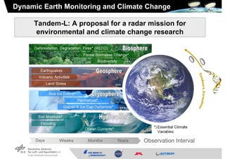
Tandem-L is a proposed mission to monitor dynamic earth processes using radar. It would provide high-resolution measurements of forests, biomass, earthquakes, volcanoes, sea ice, permafrost, soil moisture, glaciers, and ocean currents. Tandem-L aims to improve on current missions by offering 3-10 meter resolution with weekly coverage. Its digital beamforming radar system could measure deformation, ice flow, water levels, and generate digital terrain models. The mission would advance understanding of processes like deforestation, forest biomass change, biodiversity, landslides, and help monitor essential climate variables.


![Forest Height Estimation (3D Structure Mode)
Pol-InSAR Forest Height [m]
Forest Height (in Situ) [m]](https://image.slidesharecdn.com/tandem-l-igarss-v2-final-2011-110726151453-phpapp02/85/Tandem-L-IGARSS-v2-final-2011-pdf-6-320.jpg)


![Hydrosphere: Soil Moisture
SMOS SMAP
50
40
30
35 km resolution 10-40 km resolution
20
10
Tandem-L
Tandem-L provides unique & 0
complementary information:
3 – 10 m resolution [vol.%]
weekly coverage • soil moisture
• water level changes
• river & ocean currents
• weekly coverage & high resolution](https://image.slidesharecdn.com/tandem-l-igarss-v2-final-2011-110726151453-phpapp02/85/Tandem-L-IGARSS-v2-final-2011-pdf-14-320.jpg)