Studywithfraca
•Download as PPTX, PDF•
2 likes•810 views

The document provides instructions for using FracaFlow software to model fractures in reservoirs. It includes steps for loading data, analyzing structures, faults and fractures, creating zones of interest, modeling fractures, and simulating wells. Key steps are importing data like grids, horizons, wells and facies; analyzing structures, faults and fractures; creating lithostratigraphic scales; modeling fractures parallel to faults or stratified by facies; generating discrete fracture networks; and adding data for permeability, mud losses, production etc. The document contains detailed procedures and parameters for fracture modeling and simulation in normal fault and fold-related reservoirs.
![NORMAL FAULT ,[object Object]](data:image/gif;base64,R0lGODlhAQABAIAAAAAAAP///yH5BAEAAAAALAAAAAABAAEAAAIBRAA7)
Recommended
Recommended
More Related Content
Similar to Studywithfraca
Similar to Studywithfraca (20)
Studywithfraca
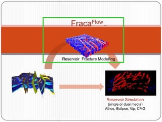
- 1. FracaFlow – ReservoirFracture Modelling Reservoir Simulation (single or dual media) Athos, Eclipse, Vip, CMG 1
- 3. Loading data
- 8. fasies
- 9. fracture
- 13. dari data grid
- 14. darihorizon
- 15. AnalisaFracture
- 16. AnalisaFault
- 17. AnalisaStruktur
- 18. MembuatZoi
- 20. Upscale
- 22. AnalisaDFN
- 28. Analisa fracture
- 29. AnalisaDinamik / InterpretasiWelltest
- 30. Analisa Fault
- 32. Import horizon; File > Import, Select ZmapMapGrid (*.dat)
- 33. Import well data; Well > Well Logs > LAS (versions 2.0 & 3.0) (.las)
- 34. Well trajectory; well Paths> ASCII column text file with header (*.asc, *.*)
- 35. Fasies; Well > Well Logs > LAS (versions 2.0 & 3.0) (.las)
- 36. Fracture; File > Import, Choose Well Fractures > ASCII Column Text File (*.asc).
- 40. Fault lineaments loading; Faults > Zmap+ (*.dat)
- 41. Fault Contours loading; Faults > Zmap+ (*.dat)
- 43. Untukkonsistensi study, facies by grid & by wells; KlikkananFacies (grid objek)> Associate property values to facies
- 44. Untuktipefacies grid 3D ygkurangbenar; Facieas property> Lithofacies type
- 47. Analisa Fracture New > Analysis > Fracture Analysis Import well data Analisa fracture: Pilih bedding Pilih Openfracture > Autogathering > move to selection by group Pilh Fault >Autogathering > move to selection by group> Bikin nama baru validasi Hubungan fractdensity dgn Lithology Facies New>Analysis>Fracture Density Log Computation Tipe sajian density frequency dapat menentukan fasies yang memiliki densitas fracture terbesar
- 50. AnalisaStruktur Dalam Fold Mengenal pola struktur/trend~distribusi fracture New > Analysis > Structural Analysis [abalisa kurvatur] Attributc omputation> smooth dulu> Attribut computtation>curvature> 1stprincipal curv. Create Fault network/ Fault picking validasi
- 51. MembuatZoi Normal Fault New>Zone of interest Input grid data; top-bottom layer Lateral Extention>Manual selection>Begin Manual Selection>Add to Zone of Interest>Add zone of Interest to Database Fold related Fault Input grid data; Well radius selection>set 1 cell around well.. >add to zoi > add zoi to database
- 53. Parallel dengan Fault (well)
- 55. @new window; difuse fracture> specific model>Fault model>stratabound> add: faultset..> rad>next
- 56. Orient..:Faultparalel>compute> von moisesstdiv: dip: 0.12 dip azm.:0.12>next
- 57. Constant>Mean: 100>conduct..: 250>cutoff:0>next ;@spatial distr.(faciestablevs density)>browse> densityMapNormalized.
- 60. @new window; difuse fracture> specific model>Facies model>stratabound> add: faultset..> rad>next
- 61. Orient..:Byunit>getmeanpole..> von moisesstdiv: dip: 0.06 dip azm.:0.08>next
- 62. @Size:lognormal>Mean: 35(?)>conduct..: 250>std.dev.:1>next; @aperture>constant, meanaperture:0.001>@cobductivityconstan, mean:700cutoff:0.1>@spatial distr.(faciestablevs density)>browse> densityMapNormalized.
- 64. Pemodelan Fracture Fold related Fault Input grid data; Well radius selection>set 1 cell around well.. >add to zoi > add zoi to database
- 65. Bersambung…