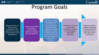
Survey Capacity
Development Program
Surveyor General Branch
(SGB)
Presentation to the NRCan Science Forum – Fredericton, N.B.
September 9, 2019
The Surveyor General Branch is a part of the Lands and Minerals Sector of Natural Resources Canada.
The staff of SGB is made up of a wide range of skilled professional and technical people :
• Professional land surveyors
• Survey engineers
• Computer specialists
• Technicians and technologists
• Administrators
• Etc.
2
The head of the Surveyor General
Branch is the Surveyor General of
Canada, Jean Gagnon, NBLS, CLS.
Introduction
International Boundary Commission (IBC)
• The boundary: Approximately 8900 km, 8 provinces and territories, 13 states
• Activities: Maintenance, land surveys, plans and reports
Canada Lands Survey System (CLSS)
• Provides the framework and infrastructure that defines, demarcates
and describes boundaries of Canada Lands.
• Documents, in conformity with the Canada Lands Surveys Act, the
administrative limits of Canada Lands, supports different land registry
systems to protect property rights.
Canadian Geodetic Survey (CGS)
• Maintains the Canadian Spatial Reference System
• Geodetic control system
• Geodetic tools and products data
3
1
2
3
4
Canada Lands are defined by section 24 (1) of the Canada Lands Survey Act.
Background
As First Nations move towards greater self-governing
responsibilities, there is an increasing need for First Nation
Administrations to play a bigger role in land surveys on
First Nation lands.
To meet this need, the Surveyor General Branch (SGB) was
tasked with developing a Survey Capacity Development Program
to support First Nation communities operating under, or
considering operating under the Framework Agreement on First
Nations Land Management.
5
The Program has been built upon the success of a First Nation-led
2015 survey capacity pilot project with Wiikwemkoong First Nation
in collaboration with the SGB in Ontario.
https://www.youtube.com/watch?v=zT-7HOc1jL4&feature=youtu.be
6
Background
BC AB SK MB ON QC ATL
NWT
MembertouTzeachten
Nipissing
Mistawasis
Muskoday
Kitselas
Shawanaga
Waban-Aki Group
Abénakis de Wôlinak
& Odanak
Current First Nation Participants as of April 29, 2019 (Year 2 of 5)
YT
NU
The Program will target 24 First Nation communities over 5 years,
providing up to 12 weeks of in-community survey capacity
development.
Background
2018 – First Nation participants
2019 – First Nation participants
7
Creating a partnership between the
First Nation and the SGB in order to
provide a personalized mentorship in
the community on the main concepts
of surveying.
- The goal of this program is to establish
relations and convey the knowledge within a
flexible and practical learning framework.
- The goal is not to train certified land
surveyors or to replace official study
programs.
8
Program Vision
Remove barriers to
effective land
management and
advance the success
of First Nations Land
Management
Increase First Nation
knowledge of
property rights
systems and spatial
data management
Enhance surveying
knowledge to allow
First Nations to
communicate their
needs effectively
with the surveying
profession, be able
to better assess the
service they receive
and help reduce the
cost of those
services
Stimulate an interest
in continuing
education in Science
and Technology,
specifically
Geomatics
Reduce economic
leakage by building
surveying skills and
capacity to do the
work within their
community
9
Program Goals
Program Overview
The program will demonstrate
the fundamentals of legal
surveys, practical techniques
and methodologies used by
industry to complete surveys;
10
Program Overview
Build skills and capacity
in researching land
records and survey plans
and how to interpret
those plans;
Parcel and
boundary
datasets
Survey Project
Search
Survey Plan
Search
(& download)
Canada Lands Survey
Records
New surveys Survey
projects
Survey
plans
CLSS Map
Browser
Canada Lands
in Google Earth
Access Methods
Geospatial
representation
(datasets)
11
Program Overview
Provide introductory experience operating the latest
survey equipment and geomatics software; and
12
Program Overview
Provide appropriate
health and safety
knowledge relevant to
field surveying activities.
13
Potential Program Participants
Provide decision-makers, lands managers,
and interested community members with
information on the role and purpose of a
land survey in effective land management
Build long-term relationships between
community, SGB and land surveyors
Generate interest in land surveying as a
potential career for community members
and provide practical experience to help
guide this decision
Provide decision-makers and lands managers
with knowledge of land surveying and legal
surveys to be informed consumers
14
Potential Program Work Plan Topics
What is land
surveying?
Why is land
surveying
important?
Why do I
need a land
surveyor?
How will this
program help?
15
Career Spotlight: Indigenous Land Surveyors
Indigenous land surveyors explain what they do, why it
matters and why surveying could be a viable career option
for Indigenous people.
https://www.youtube.com/watch?v=lW6gLwfPi4Q
16
Program Work Group Contacts
 First Nation Land Management – Research Centre
(FNLM-RC)
– Tania Bigstone – Survey Advisor (tania.bigstone@labrc.com)
 National Aboriginal Land Managers Association (NALMA)
– Graeme Sandy – Survey Project Manager (gsandy@nalma.ca)
 Crown-Indigenous Relations and Northern Affairs Canada /
Indigenous Services Canada (CIRNA/ISC)
– Dorothy Laplante – Manager, Operations and Program – Community Lands
Development (dorothy.laplante2@canada.ca)
 Surveyor General Branch (SGB)
– Rob LeBlanc – Senior Program Manager (rob.leblanc@canada.ca)
17
Indigenous Services
Canada
Services aux
Autochtones Canada
Natural Resources
Canada
Ressources Naturelles
Canada
Questions?
18

SGB Survey Capacity Development Program

  • 1.
    Survey Capacity Development Program SurveyorGeneral Branch (SGB) Presentation to the NRCan Science Forum – Fredericton, N.B. September 9, 2019
  • 2.
    The Surveyor GeneralBranch is a part of the Lands and Minerals Sector of Natural Resources Canada. The staff of SGB is made up of a wide range of skilled professional and technical people : • Professional land surveyors • Survey engineers • Computer specialists • Technicians and technologists • Administrators • Etc. 2 The head of the Surveyor General Branch is the Surveyor General of Canada, Jean Gagnon, NBLS, CLS. Introduction
  • 3.
    International Boundary Commission(IBC) • The boundary: Approximately 8900 km, 8 provinces and territories, 13 states • Activities: Maintenance, land surveys, plans and reports Canada Lands Survey System (CLSS) • Provides the framework and infrastructure that defines, demarcates and describes boundaries of Canada Lands. • Documents, in conformity with the Canada Lands Surveys Act, the administrative limits of Canada Lands, supports different land registry systems to protect property rights. Canadian Geodetic Survey (CGS) • Maintains the Canadian Spatial Reference System • Geodetic control system • Geodetic tools and products data 3 1 2 3
  • 4.
    4 Canada Lands aredefined by section 24 (1) of the Canada Lands Survey Act.
  • 5.
    Background As First Nationsmove towards greater self-governing responsibilities, there is an increasing need for First Nation Administrations to play a bigger role in land surveys on First Nation lands. To meet this need, the Surveyor General Branch (SGB) was tasked with developing a Survey Capacity Development Program to support First Nation communities operating under, or considering operating under the Framework Agreement on First Nations Land Management. 5
  • 6.
    The Program hasbeen built upon the success of a First Nation-led 2015 survey capacity pilot project with Wiikwemkoong First Nation in collaboration with the SGB in Ontario. https://www.youtube.com/watch?v=zT-7HOc1jL4&feature=youtu.be 6 Background
  • 7.
    BC AB SKMB ON QC ATL NWT MembertouTzeachten Nipissing Mistawasis Muskoday Kitselas Shawanaga Waban-Aki Group Abénakis de Wôlinak & Odanak Current First Nation Participants as of April 29, 2019 (Year 2 of 5) YT NU The Program will target 24 First Nation communities over 5 years, providing up to 12 weeks of in-community survey capacity development. Background 2018 – First Nation participants 2019 – First Nation participants 7
  • 8.
    Creating a partnershipbetween the First Nation and the SGB in order to provide a personalized mentorship in the community on the main concepts of surveying. - The goal of this program is to establish relations and convey the knowledge within a flexible and practical learning framework. - The goal is not to train certified land surveyors or to replace official study programs. 8 Program Vision
  • 9.
    Remove barriers to effectiveland management and advance the success of First Nations Land Management Increase First Nation knowledge of property rights systems and spatial data management Enhance surveying knowledge to allow First Nations to communicate their needs effectively with the surveying profession, be able to better assess the service they receive and help reduce the cost of those services Stimulate an interest in continuing education in Science and Technology, specifically Geomatics Reduce economic leakage by building surveying skills and capacity to do the work within their community 9 Program Goals
  • 10.
    Program Overview The programwill demonstrate the fundamentals of legal surveys, practical techniques and methodologies used by industry to complete surveys; 10
  • 11.
    Program Overview Build skillsand capacity in researching land records and survey plans and how to interpret those plans; Parcel and boundary datasets Survey Project Search Survey Plan Search (& download) Canada Lands Survey Records New surveys Survey projects Survey plans CLSS Map Browser Canada Lands in Google Earth Access Methods Geospatial representation (datasets) 11
  • 12.
    Program Overview Provide introductoryexperience operating the latest survey equipment and geomatics software; and 12
  • 13.
    Program Overview Provide appropriate healthand safety knowledge relevant to field surveying activities. 13
  • 14.
    Potential Program Participants Providedecision-makers, lands managers, and interested community members with information on the role and purpose of a land survey in effective land management Build long-term relationships between community, SGB and land surveyors Generate interest in land surveying as a potential career for community members and provide practical experience to help guide this decision Provide decision-makers and lands managers with knowledge of land surveying and legal surveys to be informed consumers 14
  • 15.
    Potential Program WorkPlan Topics What is land surveying? Why is land surveying important? Why do I need a land surveyor? How will this program help? 15
  • 16.
    Career Spotlight: IndigenousLand Surveyors Indigenous land surveyors explain what they do, why it matters and why surveying could be a viable career option for Indigenous people. https://www.youtube.com/watch?v=lW6gLwfPi4Q 16
  • 17.
    Program Work GroupContacts  First Nation Land Management – Research Centre (FNLM-RC) – Tania Bigstone – Survey Advisor (tania.bigstone@labrc.com)  National Aboriginal Land Managers Association (NALMA) – Graeme Sandy – Survey Project Manager (gsandy@nalma.ca)  Crown-Indigenous Relations and Northern Affairs Canada / Indigenous Services Canada (CIRNA/ISC) – Dorothy Laplante – Manager, Operations and Program – Community Lands Development (dorothy.laplante2@canada.ca)  Surveyor General Branch (SGB) – Rob LeBlanc – Senior Program Manager (rob.leblanc@canada.ca) 17
  • 18.
    Indigenous Services Canada Services aux AutochtonesCanada Natural Resources Canada Ressources Naturelles Canada Questions? 18

Editor's Notes

  • #2 Engagement and relationship building with Indigenous peoples through community outreach and capacity building.
  • #3 The SGB has supported the Canada Lands Survey system since 1871 and the geodetic survey system since 1909. The office’s staff is made up of various professionals and technicians: surveyors, survey engineers, IT specialists, technologists, and administrative staff. The Surveyor General Branch reports to the Surveyor General of Canada Lands (Jean Gagnon), who is also Canada’s commissioner on the International Boundary Commission.
  • #5 The Canada Lands Survey System (CLSS) provides the framework and infrastructure for defining, demarcating and describing boundaries of Canada Lands and of private lands in the North.
  • #7 Present Wiikwemkoong video. https://www.youtube.com/watch?v=zT-7HOc1jL4&feature=youtu.be
  • #8 The Survey Capacity Development Program (the “Program”) will target 24 First Nation communities over 5 years (2018-19 to 2022-23) and will provide up to 12 weeks of in-community training.
  • #10 The Program will be customized to the First Nation’s needs, consisting of up to 12-weeks of in-community capacity development, delivered over a span of up to 24 months in order to provide time for participants to absorb information, conduct research (both external and internal) and experiment on their own between in-community sessions. Participants shall work side-by-side with SGB staff to build on existing skills and experience to apply practical context to any previous traditional or online education they have acquired. The program will demonstrate the fundamentals of legal surveys, practical techniques and methodologies used by industry to complete surveys; build skills and capacity in researching and interpreting land records and survey plans; and provide health and safety knowledge relevant to field survey activities. Successful participants will receive a Letter of Congratulation from the Surveyor General of Canada Lands (this is not an academically accredited certificate).
  • #15 Potential candidates will be employees or members of their respective Indigenous communities. The goal will be to provide practical knowledge in land surveying principles and techniques, and an understanding of how surveys support interests in First Nation lands. Communities identifying participants from Administration offices directly affected by surveys (Lands, Public Works, Housing and Infrastructure etc.), along with candidates willing to explore continuing education and commencing on a career path to become survey technicians, survey technologists, or accredited professional land surveyors shall be given preference.