Download to read offline


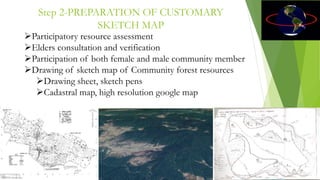


This document describes a methodology for using geo-spatial technology to assist communities in participatory mapping of their forest resources. The methodology involves: (1) preparatory discussions with community members; (2) creating sketch maps of forest areas; (3) training local youth to use GPS devices; (4) visiting forest locations with the community to record GPS data; and (5) generating GIS maps from the GPS data. The goal is to clearly map community forest boundaries and resources to support legal claims over these areas under the Forest Rights Act of 2006. The process empowers communities and local youth through training and produces maps that are useful for resource management, research, and advocacy around land rights policies.


![[Challenge:Future] Need some green intervention??? what about community fores...](https://cdn.slidesharecdn.com/ss_thumbnails/challengefuture-need-some-green-intervention-what-about-community-forestry1025-130227121355-phpapp02-thumbnail.jpg?width=640&height=640&fit=bounds)


![[Day 2] Center Presentation: CIFOR](https://cdn.slidesharecdn.com/ss_thumbnails/cgiar-csi-day2-1apr2009-center-cifor-090405003500-phpapp02-thumbnail.jpg?width=640&height=640&fit=bounds)


