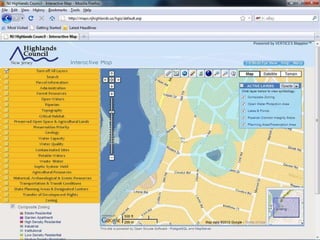
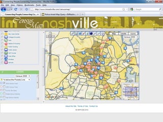
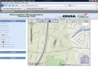
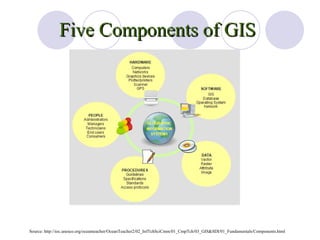
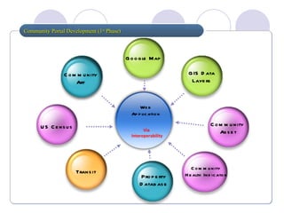
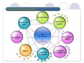
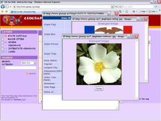
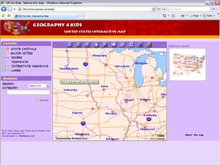
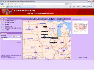
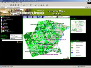
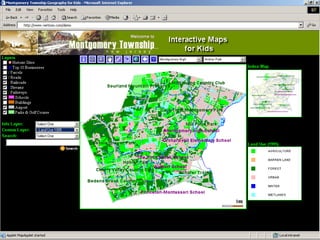
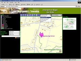
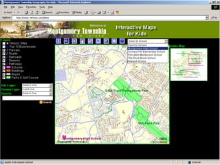
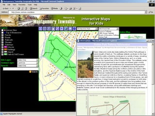
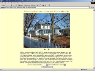
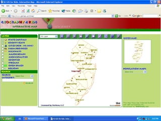
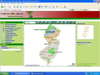
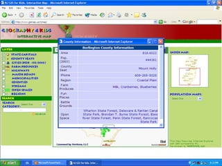
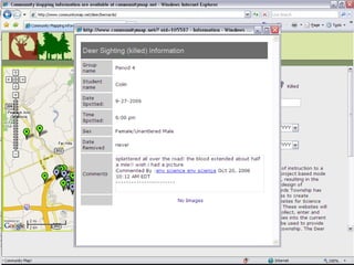
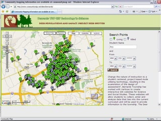
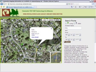
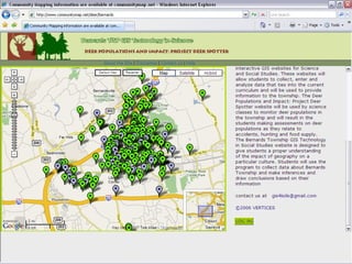
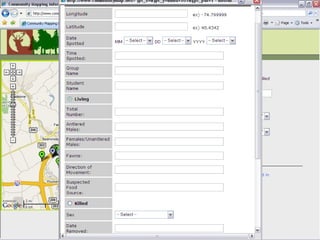
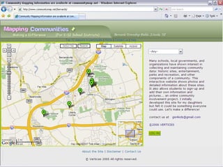
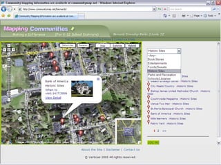
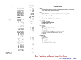
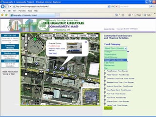
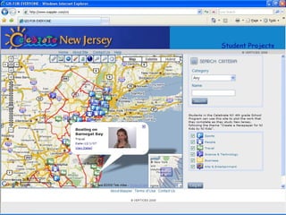
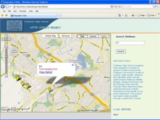
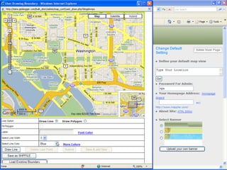
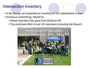
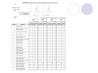
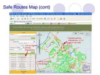
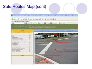
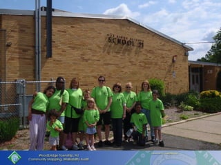
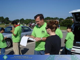
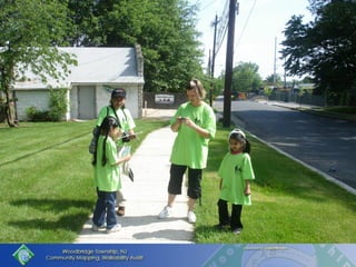
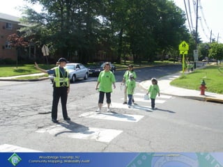
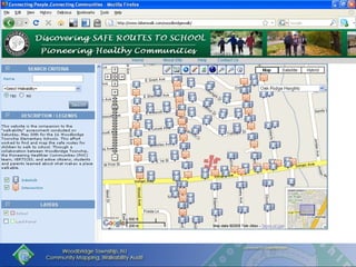
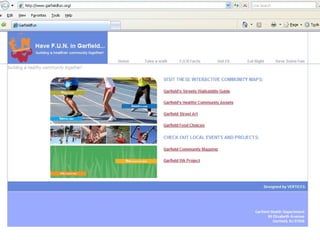
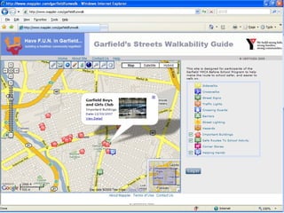
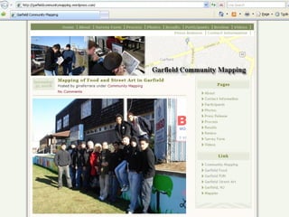
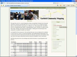
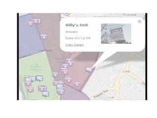
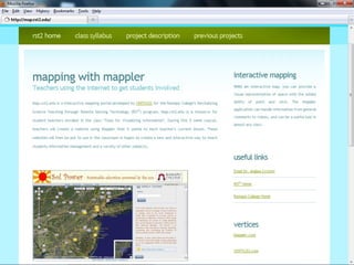
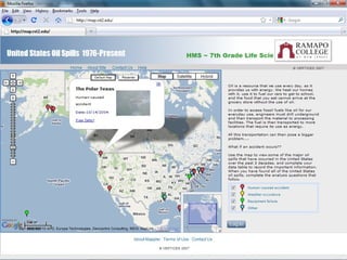
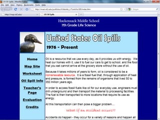
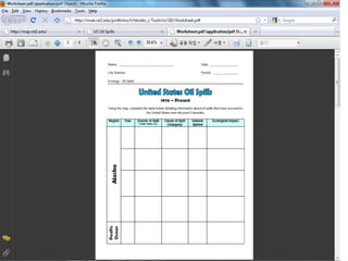
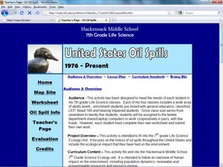
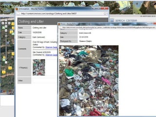
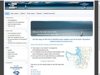
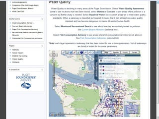
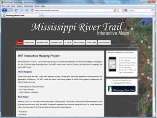
Serving Communities and Learning GIS Technology Engaging youth with their communities by using Public Participatory GIS Wansoo Im, Ph.D. VERTICES [email_address] www.gis4kids.com U of Wisconsin-Milwaukee GIS Day 2010


Five Components of GIS Source: http://ioc.unesco.org/oceanteacher/OceanTeacher2/02_InfTchSciCmm/01_CmpTch/03_GIS&SDI/01_Fundamentals/Components.html
Currently Available US Census Google Map GIS Data Layers Community  Asset Community Art Transit Property Database Community Health Indicator
Community Portal Development (1 st  Phase) Via  Interoperability Web Application US Census Homicide Google Map GIS Data Layers Community  Asset Community Health Indicator Transit Community Art Property Database
Community Portal Development (2 nd  Phase) Via  Interoperability Property Database Community Health Indicator Community  Asset GIS Data Layers Google Map Community Art US Census Transit Web Application Community Health Indicator Community  Asset Google Map US Census Transit
Community Portal Development (3rd Phase) Via  Interoperability Property Database Transit US Census Community Art Google Map GIS Data Layers Community  Asset Web Application Community Health Indicator Transit US Census Google Map Community  Asset
Learning Geography by Using Paper Map:


Applying Interactive Maps to the Social Study Curriculum in the School System K,1-2 Community Helper Grade 3 Tour of Montgomery Sites Native Americans in Montgomery Township Grade 4 European Explorers American Revolution Washington’s Retreat Map of British Route
Applying Interactive Maps to the Social Study Curriculum in the School System Grade 5 Revolution (American History) Pioneers Heading West Oregon Trail Grade 6 Ancient Civilization (Pre-History) Egypt
Suggestion from 3 rd  Grade Teachers Location of calcite, fluorite, gypsum, hornblende, basalt, sandstone, limestone, marble, granite, feldspar, mica, in Montgomery, Somerset County, New Jersey, US, (zoom in-zoom out)  Ability for students to input mineral rock types and samples as they travel collecting rock samples.  Location of caves and sinkholes, fossil locations (Haddonfield, etc.) Link to local geologists that we can email.
Suggestion from 3 rd  Grade Teachers Students create an inventory of the Earth materials used in the construction of their home (inside and out) and compare with other classes in other regions of the country. Topographical maps of the US (zoom in-zoom out) Site organized by content (curriculum unit) Native Americans Earth Materials
Suggestion from 3 rd  Grade Teachers Students create their own points of interest maps (soccer field, dancing school, home, school, restaurant, religious, Calculate distances between points. Students input (or are provided speed limit data) maps and calculate driving time from point to point. Bluebird (any bird) sightings from school and at home. Types of trees Montgomery, Somerset County, New Jersey, US, (zoom in-zoom out).
Suggestion from 3 rd  Grade Teachers Students input data -What’s blooming now at my house (connect with other schools). Students input data- Connection between blossoms and sighting of pollinators (bees, butterflies). Maps of power outages, power use versus time of day Superposition of the Earth materials we study and Native American regions (Desert Southwest, Pacific Northwest, Great Plains, Eastern woodlands.
Suggestion from 3 rd  Grade Teachers Water sources (natural and man-made). Water source/availability versus Native American settlements. Montgomery settlement- Why here?  Soil quality, location, climate, ease of travel, water.


www.CenterForCommunityMapping.org Deer Populations and Impact: Project Deer Spotter GIS in Curriculum Design
Lessons Learned EASY  to; Learn Create Use Access Duplicate Share Data Validation (Control)
Lessons Learned Education & Outreach Work with Teachers involved in Curriculum Time and Resource Commitment Continuation of the Project


In the Spring, we conducted an inventory of 193 intersections in town Enormous undertaking, helped by: Global Volunteer Day grant from McGraw-Hill  The combined effort of over 30 volunteers (including the Mayor!) Intersection Inventory


Safe Routes Map (cont)
 
May 30 th , 2009 Woodbridge Township Pioneering Healthy Communities Community Mapping Walkability Audit Safe Routes to School


Community Mapping with Where 2.0 Education Technology Environment Community Health


What is Happening  Interoperability Interoperability Interoperability   Interoperability……
Community Portal Development (3rd Phase) Via  Interoperability Property Database Transit US Census Community Art Google Map GIS Data Layers Community  Asset Web Application Community Health Indicator Transit US Census Google Map Community  Asset
 
"Connecting People and Connecting Communities"    -  Empowering the Public and Communities with GIS Technology -
Wansoo Im, Ph.D. email: im@vertices.com http://www.ilovegeography.com Contact:

Serving Communities and Learning GIS Technology

  • 1.
    Serving Communities andLearning GIS Technology Engaging youth with their communities by using Public Participatory GIS Wansoo Im, Ph.D. VERTICES [email_address] www.gis4kids.com U of Wisconsin-Milwaukee GIS Day 2010
  • 2.
  • 3.
  • 4.
  • 5.
  • 6.
  • 7.
  • 8.
  • 9.
    Five Components ofGIS Source: http://ioc.unesco.org/oceanteacher/OceanTeacher2/02_InfTchSciCmm/01_CmpTch/03_GIS&SDI/01_Fundamentals/Components.html
  • 10.
    Five Components ofGIS Source: http://ioc.unesco.org/oceanteacher/OceanTeacher2/02_InfTchSciCmm/01_CmpTch/03_GIS&SDI/01_Fundamentals/Components.html
  • 11.
    Currently Available USCensus Google Map GIS Data Layers Community Asset Community Art Transit Property Database Community Health Indicator
  • 12.
    Community Portal Development(1 st Phase) Via Interoperability Web Application US Census Homicide Google Map GIS Data Layers Community Asset Community Health Indicator Transit Community Art Property Database
  • 13.
    Community Portal Development(2 nd Phase) Via Interoperability Property Database Community Health Indicator Community Asset GIS Data Layers Google Map Community Art US Census Transit Web Application Community Health Indicator Community Asset Google Map US Census Transit
  • 14.
    Community Portal Development(3rd Phase) Via Interoperability Property Database Transit US Census Community Art Google Map GIS Data Layers Community Asset Web Application Community Health Indicator Transit US Census Google Map Community Asset
  • 15.
    Learning Geography byUsing Paper Map:
  • 16.
  • 17.
  • 18.
  • 19.
  • 20.
  • 21.
  • 22.
  • 23.
  • 24.
  • 25.
  • 26.
  • 27.
    Applying Interactive Mapsto the Social Study Curriculum in the School System K,1-2 Community Helper Grade 3 Tour of Montgomery Sites Native Americans in Montgomery Township Grade 4 European Explorers American Revolution Washington’s Retreat Map of British Route
  • 28.
    Applying Interactive Mapsto the Social Study Curriculum in the School System Grade 5 Revolution (American History) Pioneers Heading West Oregon Trail Grade 6 Ancient Civilization (Pre-History) Egypt
  • 29.
    Suggestion from 3rd Grade Teachers Location of calcite, fluorite, gypsum, hornblende, basalt, sandstone, limestone, marble, granite, feldspar, mica, in Montgomery, Somerset County, New Jersey, US, (zoom in-zoom out) Ability for students to input mineral rock types and samples as they travel collecting rock samples. Location of caves and sinkholes, fossil locations (Haddonfield, etc.) Link to local geologists that we can email.
  • 30.
    Suggestion from 3rd Grade Teachers Students create an inventory of the Earth materials used in the construction of their home (inside and out) and compare with other classes in other regions of the country. Topographical maps of the US (zoom in-zoom out) Site organized by content (curriculum unit) Native Americans Earth Materials
  • 31.
    Suggestion from 3rd Grade Teachers Students create their own points of interest maps (soccer field, dancing school, home, school, restaurant, religious, Calculate distances between points. Students input (or are provided speed limit data) maps and calculate driving time from point to point. Bluebird (any bird) sightings from school and at home. Types of trees Montgomery, Somerset County, New Jersey, US, (zoom in-zoom out).
  • 32.
    Suggestion from 3rd Grade Teachers Students input data -What’s blooming now at my house (connect with other schools). Students input data- Connection between blossoms and sighting of pollinators (bees, butterflies). Maps of power outages, power use versus time of day Superposition of the Earth materials we study and Native American regions (Desert Southwest, Pacific Northwest, Great Plains, Eastern woodlands.
  • 33.
    Suggestion from 3rd Grade Teachers Water sources (natural and man-made). Water source/availability versus Native American settlements. Montgomery settlement- Why here? Soil quality, location, climate, ease of travel, water.
  • 34.
  • 35.
  • 36.
  • 37.
  • 38.
  • 39.
  • 40.
  • 41.
  • 42.
  • 43.
  • 44.
  • 45.
  • 46.
  • 47.
  • 48.
  • 49.
  • 50.
  • 51.
  • 52.
  • 53.
  • 54.
  • 55.
  • 56.
    www.CenterForCommunityMapping.org Deer Populationsand Impact: Project Deer Spotter GIS in Curriculum Design
  • 57.
    Lessons Learned EASY to; Learn Create Use Access Duplicate Share Data Validation (Control)
  • 58.
    Lessons Learned Education& Outreach Work with Teachers involved in Curriculum Time and Resource Commitment Continuation of the Project
  • 59.
  • 60.
  • 61.
  • 62.
  • 63.
    In the Spring,we conducted an inventory of 193 intersections in town Enormous undertaking, helped by: Global Volunteer Day grant from McGraw-Hill The combined effort of over 30 volunteers (including the Mayor!) Intersection Inventory
  • 64.
  • 65.
  • 66.
  • 67.
  • 68.
  • 69.
  • 70.
    May 30 th, 2009 Woodbridge Township Pioneering Healthy Communities Community Mapping Walkability Audit Safe Routes to School
  • 71.
  • 72.
  • 73.
  • 74.
  • 75.
  • 76.
  • 77.
  • 78.
  • 79.
  • 80.
  • 81.
  • 82.
  • 83.
  • 84.
  • 85.
  • 86.
  • 87.
  • 88.
  • 89.
  • 90.
  • 91.
    Community Mapping withWhere 2.0 Education Technology Environment Community Health
  • 92.
  • 93.
  • 94.
  • 95.
  • 96.
  • 97.
  • 98.
  • 99.
  • 100.
  • 101.
  • 102.
  • 103.
  • 104.
  • 105.
  • 106.
  • 107.
  • 108.
  • 109.
  • 110.
  • 111.
  • 112.
  • 113.
  • 114.
  • 115.
  • 116.
    What is Happening Interoperability Interoperability Interoperability Interoperability……
  • 117.
    Community Portal Development(3rd Phase) Via Interoperability Property Database Transit US Census Community Art Google Map GIS Data Layers Community Asset Web Application Community Health Indicator Transit US Census Google Map Community Asset
  • 118.
  • 119.
    "Connecting People andConnecting Communities"    - Empowering the Public and Communities with GIS Technology -
  • 120.
    Wansoo Im, Ph.D.email: im@vertices.com http://www.ilovegeography.com Contact:

Editor's Notes

  • #2 This presentation will describe how local governments have applied internet /intranet technology to successfully achieve the effective use of GIS for local government and broadening GIS Benefits to other organizations in the municipality. We will show a internet GIS application which we developed as a demonstration case for Montgomery township school district.
  • #57 This presentation will describe how local governments have applied internet /intranet technology to successfully achieve the effective use of GIS for local government and broadening GIS Benefits to other organizations in the municipality. We will show a internet GIS application which we developed as a demonstration case for Montgomery township school district.
  • #74 YMCA Pioneering Healthier Communities
  • #75 16 Local Elementary Schools Children and Parents Helping Community
  • #78 Police Department Was Helping.
  • #81 Volunteers from Rutgers!
  • #83 Volunteers from Rutgers University, University of Miami and other Professionals
  • #97 Volunteers from Rutgers University, University of Miami and other Professionals