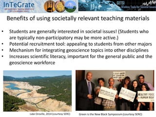
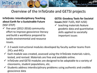
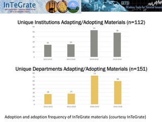
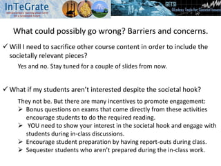
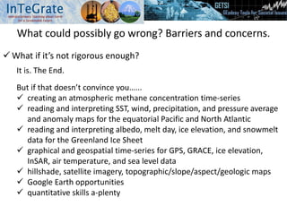
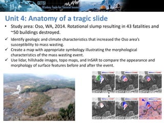
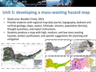
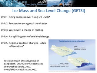
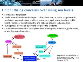
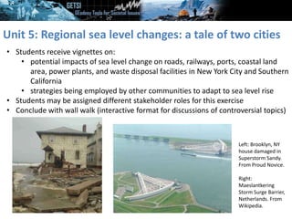
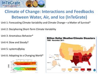
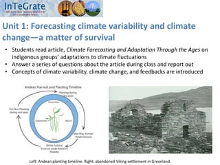
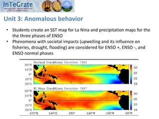
Infusing activities with a strong societal component
into your teaching
Becca Walker, Cynthia Fadem, Cindy Shellito, Leigh Stearns, Sarah Hall, David
McConnell, Beth Pratt-Sitaula
Strong Starts and Transitions workshop; August 25, 2018
Session goal
Explore published teaching activities with strong
societal components that can be used in your
introductory-level courses.
Tentative plan for the next hour
 Benefits of societally relevant curricular materials
 Where you can get these materials (InTeGrate and GETSI projects)
 Challenges/pitfalls of incorporating them into your classroom
 Examples of societally relevant classroom exercises for introductory-
level students
 Surface Process Hazards (Hall and Walker—GETSI)
 Ice Mass and Sea Level Change (Stearns and Walker—GETSI)
 Climate of Change (Fadem, Shellito, and Walker—InTeGrate)
 Time available for you to explore an InTeGrate or GETSI module
Benefits of using societally relevant teaching materials
• Students are generally interested in societal issues! (Students who
are typically non-participatory may be more active.)
• Potential recruitment tool: appealing to students from other majors
• Mechanism for integrating geoscience topics into other disciplines
• Increases scientific literacy, important for the general public and the
geoscience workforce
Lake Oroville, 2014 (courtesy SERC) Green is the New Black Symposium (courtesy SERC)
Overview of the InTeGrate and GETSI projects
InTeGrate: Interdisciplinary Teaching
about Earth for a Sustainable Future
(NSF-STEP)
 five-year (2012-2016) community
effort to improve geoscience literacy
and build a workforce prepared to
tackle environmental and resource
issues.
GETSI: Geodesy Tools for Societal
Issues (NSF-TUES, NSF-IUSE)
 teaching materials feature
geodetic data and quantitative
skills applied to societally
important issues
 2-3 week instructional modules developed by faculty author teams from
2YCs and 4YCs
 Each module was created, assessed using the InTeGrate materials rubric,
tested, and revised. Materials are free and available online.
 InTeGrate and GETSI modules are designed to be adaptable to a variety of
classrooms, student populations, etc.
 Students address interdisciplinary problems using authentic and credible
geoscience data
Adoption and adoption frequency of InTeGrate materials (courtesy InTeGrate)
What could possibly go wrong? Barriers and concerns.
 Will I need to sacrifice other course content in order to include the
societally relevant pieces?
 What if my students aren’t interested despite the societal hook?
Yes and no. Stay tuned for a couple of slides from now.
They not be. But there are many incentives to promote engagement:
 Bonus questions on exams that come directly from these activities
encourage students to do the required reading.
 YOU need to show your interest in the societal hook and engage with
students during in-class discussions.
 Encourage student preparation by having report-outs during class.
 Sequester students who aren’t prepared during the in-class work.
What could possibly go wrong? Barriers and concerns.
 What if it’s not rigorous enough?
It is. The End.
But if that doesn’t convince you…...
 creating an atmospheric methane concentration time-series
 reading and interpreting SST, wind, precipitation, and pressure average
and anomaly maps for the equatorial Pacific and North Atlantic
 reading and interpreting albedo, melt day, ice elevation, and snowmelt
data for the Greenland Ice Sheet
 graphical and geospatial time-series for GPS, GRACE, ice elevation,
InSAR, air temperature, and sea level data
 hillshade, satellite imagery, topographic/slope/aspect/geologic maps
 Google Earth opportunities
 quantitative skills a-plenty
What could possibly go wrong? Barriers and concerns.
 How will I scaffold this into my existing course?
 Reality check: it is NOT reasonable to think that you can implement these
materials with no preparation.
 Go through the exercises, answer keys, and instructor stories first.
 Be realistic about the time that it will take to implement in your class.
 Suggestions for scaffolding into your curriculum:
 Many modules include student prep exercises to increase efficiency of
the in-class component.
 Example: students read an article before coming to class and do a
gallery walk about the article during class
 Think about what these materials could replace in your course, perhaps
from a skills perspective rather than a content perspective
 Examples: calculating slope, recognizing spatial patterns
 Consider engineering student groups to maximize learning and efficiency.
 Example: some data sets are more time and labor intensive than
others. Which students would work best with these data?
What could possibly go wrong? Barriers and concerns.
 I’m not a (geomorphologist, paleoclimatologist, mineralogist,
seismologist, hydrologist,…....) Can I still make the materials work?
solution keys instructor stories and all imagery, text,
teaching tips and slides provided
High: around MSH and steep cliffs
Medium: moderate slope angle
Low: low slope and far from steep slopes
Above: annotated hillshade image of
Yosemite National Park
Surface Process Hazards (GETSI)
Unit 1: Slip-sliding away—case study landslides in Italy and Peru*
Unit 2: Reading the landscape
Unit 3: Understanding landslide factors
Unit 4: Anatomy of a tragic slide—Oso landslide case study*
Unit 5 Mitigating future disasters—developing a mass-wasting hazard map*
Yungay Viejo (2500 m) as seen from
the cemetery hill. The light shaded
area shows the location of the
landslide (ice, mud, debris avalanche)
on 31.05.1970, caused by an
earthquake, in which a part of the
western flank of Huascaran Norte
broke (6652 m).
Unit 1: slip-sliding away
• Study areas: Peru (1970), Sicily (2010)
• Students read article on 2 mass wasting events and respond to discussion
questions
• Article focuses on geologic and climate factors that contributed to the events and
the impact on landscape, infrastructure, and human life
• Could be implemented as a homework, whole-group discussion, or gallery walk
Above: Infrastructure damage as
a result of the 2010 San Fratello
event. From ISPRA.
Below: town of Yungay, Peru and
surrounding rural area before (A) and
after (B) the 1970 debris flow. From
National Information Service for
Earthquake Engineering, UC Berkeley.
Unit 4: Anatomy of a tragic slide
• Study area: Oso, WA, 2014. Rotational slump resulting in 43 fatalities and
~50 buildings destroyed.
N
5
0
 Identify geologic and climate characteristics that increased the Oso area’s
susceptibility to mass wasting.
 Create a map with appropriate symbology illustrating the morphological
characteristics of the mass wasting event.
 Use lidar, hillshade images, topo maps, and InSAR to compare the appearance and
morphology of surface features before and after the event.
Unit 5: developing a mass-wasting hazard map
• Study area: Boulder Creek, 2013
• Provide students with regional map data (aerial, topography, bedrock and
surficial geology, slope, aspect, hillshade, streams, population density),
thought questions, and report instructions
• Students produce a map with high, medium, and low mass wasting
hazards, written justification, and specific suggestions for planning and
mitigation
Ice Mass and Sea Level Change (GETSI)
Unit 1: Rising concerns over rising sea levels*
Unit 2: Temperature—a global trendsetter
Unit 3: Warm with a chance of melting
Unit 4: An uplifting story of sea level change
Unit 5: Regional sea level changes—a tale
of two cities*
Potential impact of sea level rise on
Bangladesh. UNEP/GRID=Arendal Maps
and Graphics Library. 2000.
UNEP/GRID-Arendal 30 Jan 2010.
Unit 1: Rising concerns over rising sea levels
• Study area: Bangladesh
• Students read article on the impacts of sea level rise on storm surge hazards,
freshwater contamination, land loss, commerce, agriculture, tourism, public
health, fisheries, the salt industry, and national security in Bangladesh.
• During class, discussion questions are posed to students.
• Could be implemented as think-pair-share, small-group discussion, gallery walk,
or whole-group discussion.
Impact of sea level rise on
Bangladesh security. From
Sarwar, 2005.
Unit 5: Regional sea level changes: a tale of two cities
• Students receive vignettes on:
• potential impacts of sea level change on roads, railways, ports, coastal land
area, power plants, and waste disposal facilities in New York City and Southern
California
• strategies being employed by other communities to adapt to sea level rise
• Students may be assigned different stakeholder roles for this exercise
• Conclude with wall walk (interactive format for discussions of controversial topics)
Left: Brooklyn, NY
house damaged in
Superstorm Sandy.
From Proud Novice.
Right:
Maeslantkering
Storm Surge Barrier,
Netherlands. From
Wikipedia.
Climate of Change: Interactions and Feedbacks
Between Water, Air, and Ice (InTeGrate)
Unit 1: Forecasting Climate Variability and Climate Change—a Matter of Survival*
Unit 2: Deciphering Short-Term Climate Variability
Unit 3: Anomalous Behavior*
Unit 4: Slow and Steady?
Unit 5: systems@play
Unit 6: Adapting to a Changing World*
Unit 1: Forecasting climate variability and climate
change—a matter of survival
• Students read article, Climate Forecasting and Adaptation Through the Ages on
indigenous groups’ adaptations to climate fluctuations
• Answer a series of questions about the article during class and report out
• Concepts of climate variability, climate change, and feedbacks are introduced
Left: Andean planting timeline. Right: abandoned Viking settlement in Greenland.
Unit 3: Anomalous behavior
• Students create an SST map for La Nina and precipitation maps for the
the three phases of ENSO
• Phenomena with societal impacts (upwelling and its influence on
fisheries, drought, flooding) are considered for ENSO +, ENSO -, and
ENSO normal phases
Unit 6: Adapting to a Changing World
• Students assess individual, class, and national opinions on climate change
using data from Yale Program on Climate Change Communication
• Climate change mitigation vs. climate change adaptation is addressed
• Case studies for discussion are provided about:
• insurance industry response to climate change
• planning for heat waves
• Room for the River program in the Netherlands
Image from Seaside Maintenance
Exploring an InTeGrate or GETSI module
Please navigate to the following URL:
https://serc.carleton.edu/integrate/teaching_materials/index.html
• Pick one module to explore. Spend ~20 minutes reading through this
module. Write/record how you could envision incorporating portions of
the module (or the entire module, whatever will work best for your
teaching) into one of your courses. Consider in which course you’d like
to use the module and how you would incorporate it into the existing
course.
• Find a partner and spend ~5 minutes sharing what you learned
during your module reconnaissance. Talk about what and how you
plan to incorporate materials from the module and what questions you
have.
Modules to Explore
• A Growing Concern: Sustaining Soil Resources Through Local Decision Making
• Carbon, Climate, and Energy Resources
• Climate of Change: Interactions and Feedbacks between Water, Air, and Ice
• Environmental Justice and Freshwater Resources
• Humans' Dependence on Earth's Mineral Resources
• Ice Mass and Sea Level Changes
• Living on the Edge: Building Resilient Societies on Active Plate Margins
• Map your Hazards! – Assessing Hazards, Vulnerability and Risk
• Ocean Sustainability
• Surface Process Hazards

Infusing activities with a strong societal component into your teaching

  • 1.
    Infusing activities witha strong societal component into your teaching Becca Walker, Cynthia Fadem, Cindy Shellito, Leigh Stearns, Sarah Hall, David McConnell, Beth Pratt-Sitaula Strong Starts and Transitions workshop; August 25, 2018
  • 2.
    Session goal Explore publishedteaching activities with strong societal components that can be used in your introductory-level courses.
  • 3.
    Tentative plan forthe next hour  Benefits of societally relevant curricular materials  Where you can get these materials (InTeGrate and GETSI projects)  Challenges/pitfalls of incorporating them into your classroom  Examples of societally relevant classroom exercises for introductory- level students  Surface Process Hazards (Hall and Walker—GETSI)  Ice Mass and Sea Level Change (Stearns and Walker—GETSI)  Climate of Change (Fadem, Shellito, and Walker—InTeGrate)  Time available for you to explore an InTeGrate or GETSI module
  • 4.
    Benefits of usingsocietally relevant teaching materials • Students are generally interested in societal issues! (Students who are typically non-participatory may be more active.) • Potential recruitment tool: appealing to students from other majors • Mechanism for integrating geoscience topics into other disciplines • Increases scientific literacy, important for the general public and the geoscience workforce Lake Oroville, 2014 (courtesy SERC) Green is the New Black Symposium (courtesy SERC)
  • 5.
    Overview of theInTeGrate and GETSI projects InTeGrate: Interdisciplinary Teaching about Earth for a Sustainable Future (NSF-STEP)  five-year (2012-2016) community effort to improve geoscience literacy and build a workforce prepared to tackle environmental and resource issues. GETSI: Geodesy Tools for Societal Issues (NSF-TUES, NSF-IUSE)  teaching materials feature geodetic data and quantitative skills applied to societally important issues  2-3 week instructional modules developed by faculty author teams from 2YCs and 4YCs  Each module was created, assessed using the InTeGrate materials rubric, tested, and revised. Materials are free and available online.  InTeGrate and GETSI modules are designed to be adaptable to a variety of classrooms, student populations, etc.  Students address interdisciplinary problems using authentic and credible geoscience data
  • 6.
    Adoption and adoptionfrequency of InTeGrate materials (courtesy InTeGrate)
  • 7.
    What could possiblygo wrong? Barriers and concerns.  Will I need to sacrifice other course content in order to include the societally relevant pieces?  What if my students aren’t interested despite the societal hook? Yes and no. Stay tuned for a couple of slides from now. They not be. But there are many incentives to promote engagement:  Bonus questions on exams that come directly from these activities encourage students to do the required reading.  YOU need to show your interest in the societal hook and engage with students during in-class discussions.  Encourage student preparation by having report-outs during class.  Sequester students who aren’t prepared during the in-class work.
  • 8.
    What could possiblygo wrong? Barriers and concerns.  What if it’s not rigorous enough? It is. The End. But if that doesn’t convince you…...  creating an atmospheric methane concentration time-series  reading and interpreting SST, wind, precipitation, and pressure average and anomaly maps for the equatorial Pacific and North Atlantic  reading and interpreting albedo, melt day, ice elevation, and snowmelt data for the Greenland Ice Sheet  graphical and geospatial time-series for GPS, GRACE, ice elevation, InSAR, air temperature, and sea level data  hillshade, satellite imagery, topographic/slope/aspect/geologic maps  Google Earth opportunities  quantitative skills a-plenty
  • 9.
    What could possiblygo wrong? Barriers and concerns.  How will I scaffold this into my existing course?  Reality check: it is NOT reasonable to think that you can implement these materials with no preparation.  Go through the exercises, answer keys, and instructor stories first.  Be realistic about the time that it will take to implement in your class.  Suggestions for scaffolding into your curriculum:  Many modules include student prep exercises to increase efficiency of the in-class component.  Example: students read an article before coming to class and do a gallery walk about the article during class  Think about what these materials could replace in your course, perhaps from a skills perspective rather than a content perspective  Examples: calculating slope, recognizing spatial patterns  Consider engineering student groups to maximize learning and efficiency.  Example: some data sets are more time and labor intensive than others. Which students would work best with these data?
  • 10.
    What could possiblygo wrong? Barriers and concerns.  I’m not a (geomorphologist, paleoclimatologist, mineralogist, seismologist, hydrologist,…....) Can I still make the materials work? solution keys instructor stories and all imagery, text, teaching tips and slides provided High: around MSH and steep cliffs Medium: moderate slope angle Low: low slope and far from steep slopes Above: annotated hillshade image of Yosemite National Park
  • 11.
    Surface Process Hazards(GETSI) Unit 1: Slip-sliding away—case study landslides in Italy and Peru* Unit 2: Reading the landscape Unit 3: Understanding landslide factors Unit 4: Anatomy of a tragic slide—Oso landslide case study* Unit 5 Mitigating future disasters—developing a mass-wasting hazard map* Yungay Viejo (2500 m) as seen from the cemetery hill. The light shaded area shows the location of the landslide (ice, mud, debris avalanche) on 31.05.1970, caused by an earthquake, in which a part of the western flank of Huascaran Norte broke (6652 m).
  • 12.
    Unit 1: slip-slidingaway • Study areas: Peru (1970), Sicily (2010) • Students read article on 2 mass wasting events and respond to discussion questions • Article focuses on geologic and climate factors that contributed to the events and the impact on landscape, infrastructure, and human life • Could be implemented as a homework, whole-group discussion, or gallery walk Above: Infrastructure damage as a result of the 2010 San Fratello event. From ISPRA. Below: town of Yungay, Peru and surrounding rural area before (A) and after (B) the 1970 debris flow. From National Information Service for Earthquake Engineering, UC Berkeley.
  • 13.
    Unit 4: Anatomyof a tragic slide • Study area: Oso, WA, 2014. Rotational slump resulting in 43 fatalities and ~50 buildings destroyed. N 5 0  Identify geologic and climate characteristics that increased the Oso area’s susceptibility to mass wasting.  Create a map with appropriate symbology illustrating the morphological characteristics of the mass wasting event.  Use lidar, hillshade images, topo maps, and InSAR to compare the appearance and morphology of surface features before and after the event.
  • 14.
    Unit 5: developinga mass-wasting hazard map • Study area: Boulder Creek, 2013 • Provide students with regional map data (aerial, topography, bedrock and surficial geology, slope, aspect, hillshade, streams, population density), thought questions, and report instructions • Students produce a map with high, medium, and low mass wasting hazards, written justification, and specific suggestions for planning and mitigation
  • 15.
    Ice Mass andSea Level Change (GETSI) Unit 1: Rising concerns over rising sea levels* Unit 2: Temperature—a global trendsetter Unit 3: Warm with a chance of melting Unit 4: An uplifting story of sea level change Unit 5: Regional sea level changes—a tale of two cities* Potential impact of sea level rise on Bangladesh. UNEP/GRID=Arendal Maps and Graphics Library. 2000. UNEP/GRID-Arendal 30 Jan 2010.
  • 16.
    Unit 1: Risingconcerns over rising sea levels • Study area: Bangladesh • Students read article on the impacts of sea level rise on storm surge hazards, freshwater contamination, land loss, commerce, agriculture, tourism, public health, fisheries, the salt industry, and national security in Bangladesh. • During class, discussion questions are posed to students. • Could be implemented as think-pair-share, small-group discussion, gallery walk, or whole-group discussion. Impact of sea level rise on Bangladesh security. From Sarwar, 2005.
  • 17.
    Unit 5: Regionalsea level changes: a tale of two cities • Students receive vignettes on: • potential impacts of sea level change on roads, railways, ports, coastal land area, power plants, and waste disposal facilities in New York City and Southern California • strategies being employed by other communities to adapt to sea level rise • Students may be assigned different stakeholder roles for this exercise • Conclude with wall walk (interactive format for discussions of controversial topics) Left: Brooklyn, NY house damaged in Superstorm Sandy. From Proud Novice. Right: Maeslantkering Storm Surge Barrier, Netherlands. From Wikipedia.
  • 18.
    Climate of Change:Interactions and Feedbacks Between Water, Air, and Ice (InTeGrate) Unit 1: Forecasting Climate Variability and Climate Change—a Matter of Survival* Unit 2: Deciphering Short-Term Climate Variability Unit 3: Anomalous Behavior* Unit 4: Slow and Steady? Unit 5: systems@play Unit 6: Adapting to a Changing World*
  • 19.
    Unit 1: Forecastingclimate variability and climate change—a matter of survival • Students read article, Climate Forecasting and Adaptation Through the Ages on indigenous groups’ adaptations to climate fluctuations • Answer a series of questions about the article during class and report out • Concepts of climate variability, climate change, and feedbacks are introduced Left: Andean planting timeline. Right: abandoned Viking settlement in Greenland.
  • 20.
    Unit 3: Anomalousbehavior • Students create an SST map for La Nina and precipitation maps for the the three phases of ENSO • Phenomena with societal impacts (upwelling and its influence on fisheries, drought, flooding) are considered for ENSO +, ENSO -, and ENSO normal phases
  • 21.
    Unit 6: Adaptingto a Changing World • Students assess individual, class, and national opinions on climate change using data from Yale Program on Climate Change Communication • Climate change mitigation vs. climate change adaptation is addressed • Case studies for discussion are provided about: • insurance industry response to climate change • planning for heat waves • Room for the River program in the Netherlands Image from Seaside Maintenance
  • 22.
    Exploring an InTeGrateor GETSI module Please navigate to the following URL: https://serc.carleton.edu/integrate/teaching_materials/index.html • Pick one module to explore. Spend ~20 minutes reading through this module. Write/record how you could envision incorporating portions of the module (or the entire module, whatever will work best for your teaching) into one of your courses. Consider in which course you’d like to use the module and how you would incorporate it into the existing course. • Find a partner and spend ~5 minutes sharing what you learned during your module reconnaissance. Talk about what and how you plan to incorporate materials from the module and what questions you have.
  • 23.
    Modules to Explore •A Growing Concern: Sustaining Soil Resources Through Local Decision Making • Carbon, Climate, and Energy Resources • Climate of Change: Interactions and Feedbacks between Water, Air, and Ice • Environmental Justice and Freshwater Resources • Humans' Dependence on Earth's Mineral Resources • Ice Mass and Sea Level Changes • Living on the Edge: Building Resilient Societies on Active Plate Margins • Map your Hazards! – Assessing Hazards, Vulnerability and Risk • Ocean Sustainability • Surface Process Hazards