High pressure over Scotland will lead to dry and very warm conditions over the next few days, although some coastal areas may see low cloud and fog. On Friday, cloud and showers will spread from the west bringing potentially heavy rain, before drier weather returns over the weekend. Unsettled conditions are possible again next week with rain at times, but high pressure looks likely to become established again later.
A series of weather forecasts are provided for different regions of Scotland over a 5 day period, along with additional synoptic discussions. The forecasts predict dry, warm conditions initially, followed by increasing cloud and showers/rain spreading eastwards, with some heavy bursts possible. Wind speeds are also expected to increase. A risk assessment color code (green, amber, red) is given based on worst case scenarios for wind, rain and snowfall thresholds over the periods.
A low pressure system will bring showery conditions and a risk of thunderstorms to Scotland over the next few days. Showers will develop across western areas on Wednesday morning and spread eastward, with some heavy downpours possible. Thunderstorms may occur in northern and western parts. Showers will continue on Thursday with a risk of lightning, lingering into Friday before gradually easing. Unsettled weather with further showers is expected through the following week.
- It will be dry with some sunny spells in central and eastern areas, while western areas will see more cloud and a chance of light rain.
- Overnight, rain will move into western and central areas, possibly reaching eastern parts by dawn.
- Winds will increase on Tuesday, bringing gusts up to 45mph to northwest Scotland and the Northern Isles overnight. Showers are also expected.
A mostly cloudy and showery few days across Scotland is forecast. On the first day, showers will affect western areas including Aberdeenshire and the Moray Firth, with a risk of thunder. Further showers are expected overnight. The second day will see sunny spells but also isolated showers, clearing overnight. Patchy rain is then expected on the third day, clearing overnight but with breezier conditions.
The document provides weather forecasts for various regions of Scotland over multiple days:
- Showers and potential thunderstorms are forecast for many areas, with showers heaviest in western regions. Low pressure will bring rain bands and blustery winds.
- Daytime temperatures will range from 11-21C with overnight lows of 8-13C. Showers will continue but become fewer overnight.
- Specific forecasts are given for Perth/Angus/Aberdeen/Moray Firth, Western Isles/NW Highlands/Skye/Argyll, and Shetland/Orkney/NE Caithness outlining rain amounts, wind speeds, and risk levels. Thunder is possible but risk
Three sentences summarizing the document:
The forecast predicts a warm day with sunny spells and a chance of afternoon showers developing, mostly in northern areas, which may be heavy with an infrequent risk of lightning strikes. A few evening showers may linger in the north as well, with an isolated risk of lightning. It will become dry overnight with clear periods.
- Early mist and fog will clear to leave a dry day with sunny spells across Perth, Angus, Aberdeen and Moray Firth. It will become cloudy with patchy rain in the Western Isles, NW and Central Highlands, and Argyll. Shetland, Orkney and NE Caithness will see a mix of cloud and sunny spells.
- Overnight, cloud will build in western areas bringing patchy rain to the northwest. It will stay dry elsewhere with clear spells.
- Low pressure will move southwards bringing showery rain that will clear eastwards through the day, leaving generally settled weather. However, uncertainty remains around the exact track of heaviest showers.
The summary provides a forecast for the South East Power Distribution region over the next 5 days. Cloud will build today with sunny spells and a chance of isolated showers. Skies will clear tonight. Tomorrow will see increasing cloud and a risk of showers, possibly longer spells of rain in western areas. Showers are possible on Friday morning easing in the afternoon. Occasional showers are expected over the weekend but overall plenty of dry weather. Low pressure may bring further rain spells next week.
The forecast predicts generally dry and warm conditions for the region over the next few days, with sunny periods and temperatures reaching the mid-twenties. There is a small chance of isolated showers developing. Overnight will remain dry with clear spells. From Friday onwards, conditions may become more unsettled with an increased risk of heavier showers or spells of rain, though confidence in these forecasts is currently low.
The document provides a 5-day forecast for the SEPD region, including forecasts for maximum and minimum temperatures, wind speeds and directions, rainfall amounts, snowfall, lightning risk, and disruption potential from weather events. It forecasts generally dry conditions for the first two days with a chance of isolated showers, increasing rain and showers from the west on days three through five.
The document provides a general forecast for the SEPD region over the next 5 days. It predicts mostly dry and warm conditions with sunny periods. There is a chance of isolated showers developing, especially in the south and east. Temperatures will remain warm with highs of 25-28C and overnight lows of 12-14C. Winds will be light northwesterly.
- It will be a largely dry and sunny day with high temperatures and just a small risk of an isolated shower developing mostly in the south and west.
- Any showers will die away in the evening, leaving it dry overnight with mostly clear skies.
- There is high confidence in the forecast.
- It will be a mainly dry day with sunny spells and warm but not as hot as recently. There is a risk of a few scattered showers overnight, especially in the west.
- There will be variable cloud amounts with showers, some locally heavy with just a small chance of an isolated thunderstorm. Showers will ease away towards evening to leave it dry overnight with clear spells.
- The forecast is for a dry day with warm spells of sunshine and dry overnight with clear spells.
There will be sunny spells today but also scattered showers, especially in the east of the region where there is a small risk of lightning. Showers will ease this evening. It will be cooler than previous days. Overall it will be a dry day with warm sunshine for most areas, becoming cloudier overnight but remaining dry. The generally settled fine weather will continue on Thursday with a dry night. On Friday there is a chance of a few sharp showers, possibly with very infrequent lightning, and this chance of showers may persist overnight.
The official 2011-2012 winter forecast predicts below average to average temperatures with a cold December and January and a warm February. Snowfall amounts are predicted to be well above average across North Carolina cities such as Winston-Salem, Greensboro, Raleigh, Hickory, and Charlotte. Conditions are expected to be influenced by a weak La Niña, negative NAO and AO patterns, and a moderate negative QBO, leading to increased chances of winter storms and snow throughout the season, especially in December and January.
This document provides a 4-day weather forecast for various locations in the Philippines from October 6-9, 2017. It includes information on weather conditions such as expected precipitation, wind speeds, temperatures and wave heights. Specific details are given for areas like Metro Manila, Northern Luzon, Southern Luzon, Palawan and others. Thunderstorms and rain showers are predicted for many areas due to the Intertropical Convergence Zone affecting parts of the country.
6pm November 9th, 2010 Weather Forecast Data Sfc p.docxfredharris32
6pm November 9th, 2010
Weather Forecast Data
Sfc pres & obs: 6pm
Sfc pres & obs: 6am
700mb hghts & wind: 6pm
700mb hghts & winds: 6am
500mb hghts & Wind: 6pm
500mb hghts & Wind: 6am
Stuve Diagram: 6pm
Stuve Diagram: 6am
Lake Temperature
Lake temp
~11C/52 F
Radar Imagery
6:00 PM
7:00 PM
8:00 PM
9:00 PM
10:00 PM
11:00 PM
12:00 AM
1:00 AM
2:00 AM
3:00 AM
4:00 AM
5:00 AM
6:00 AM
7:00 AM
8:00 AM
9:00 AM
Precipitation Summary
• Around 6pm frontal precipitation began to taper off, and by 7pm
it was showery, with some lingering snowfall in the mountains.
• At 11pm a lake effect snow band forms on the north end of the
Tooele valley. It produces some brief heavy snow, but soon
dissipates.
• From 3 to 5am lake effect snow forms and begins to fall over
the Great Salt Lake, but because of light wind speeds, the
snowfall is not carried into the surrounding valleys of
mountains.
• From 6 to 8am the lake effect snow over the lake begins to
move toward Ogden propelled by a westerly wind. Ogden
experiences some periods of heavy snowfall and accumulations
of 3-5 inches.
• By 9am most precipitation has ceased.
• Throughout the night, the Salt Lake Valley received only a trace
of snow.
.
Evolving Lifecycles with High Resolution Site Characterization (HRSC) and 3-D...Joshua Orris
The incorporation of a 3DCSM and completion of HRSC provided a tool for enhanced, data-driven, decisions to support a change in remediation closure strategies. Currently, an approved pilot study has been obtained to shut-down the remediation systems (ISCO, P&T) and conduct a hydraulic study under non-pumping conditions. A separate micro-biological bench scale treatability study was competed that yielded positive results for an emerging innovative technology. As a result, a field pilot study has commenced with results expected in nine-twelve months. With the results of the hydraulic study, field pilot studies and an updated risk assessment leading site monitoring optimization cost lifecycle savings upwards of $15MM towards an alternatively evolved best available technology remediation closure strategy.
Monitor indicators of genetic diversity from space using Earth Observation dataSpatial Genetics
Genetic diversity within and among populations is essential for species persistence. While targets and indicators for genetic diversity are captured in the Kunming-Montreal Global Biodiversity Framework, assessing genetic diversity across many species at national and regional scales remains challenging. Parties to the Convention on Biological Diversity (CBD) need accessible tools for reliable and efficient monitoring at relevant scales. Here, we describe how Earth Observation satellites (EO) make essential contributions to enable, accelerate, and improve genetic diversity monitoring and preservation. Specifically, we introduce a workflow integrating EO into existing genetic diversity monitoring strategies and present a set of examples where EO data is or can be integrated to improve assessment, monitoring, and conservation. We describe how available EO data can be integrated in innovative ways to support calculation of the genetic diversity indicators of the GBF monitoring framework and to inform management and monitoring decisions, especially in areas with limited research infrastructure or access. We also describe novel, integrative approaches to improve the indicators that can be implemented with the coming generation of EO data, and new capabilities that will provide unprecedented detail to characterize the changes to Earth’s surface and their implications for biodiversity, on a global scale.
The modification of an existing product or the formulation of a new product to fill a newly identified market niche or customer need are both examples of product development. This study generally developed and conducted the formulation of aramang baked products enriched with malunggay conducted by the researchers. Specifically, it answered the acceptability level in terms of taste, texture, flavor, odor, and color also the overall acceptability of enriched aramang baked products. The study used the frequency distribution for evaluators to determine the acceptability of enriched aramang baked products enriched with malunggay. As per sensory evaluation conducted by the researchers, it was proven that aramang baked products enriched with malunggay was acceptable in terms of Odor, Taste, Flavor, Color, and Texture. Based on the results of sensory evaluation of enriched aramang baked products proven that three (3) treatments were all highly acceptable in terms of variable Odor, Taste, Flavor, Color and Textures conducted by the researchers.
The forecast predicts generally dry and warm conditions for the region over the next few days, with sunny periods and temperatures reaching the mid-twenties. There is a small chance of isolated showers developing. Overnight will remain dry with clear spells. From Friday onwards, conditions may become more unsettled with an increased risk of heavier showers or spells of rain, though confidence in these forecasts is currently low.
The document provides a 5-day forecast for the SEPD region, including forecasts for maximum and minimum temperatures, wind speeds and directions, rainfall amounts, snowfall, lightning risk, and disruption potential from weather events. It forecasts generally dry conditions for the first two days with a chance of isolated showers, increasing rain and showers from the west on days three through five.
The document provides a general forecast for the SEPD region over the next 5 days. It predicts mostly dry and warm conditions with sunny periods. There is a chance of isolated showers developing, especially in the south and east. Temperatures will remain warm with highs of 25-28C and overnight lows of 12-14C. Winds will be light northwesterly.
- It will be a largely dry and sunny day with high temperatures and just a small risk of an isolated shower developing mostly in the south and west.
- Any showers will die away in the evening, leaving it dry overnight with mostly clear skies.
- There is high confidence in the forecast.
- It will be a mainly dry day with sunny spells and warm but not as hot as recently. There is a risk of a few scattered showers overnight, especially in the west.
- There will be variable cloud amounts with showers, some locally heavy with just a small chance of an isolated thunderstorm. Showers will ease away towards evening to leave it dry overnight with clear spells.
- The forecast is for a dry day with warm spells of sunshine and dry overnight with clear spells.
There will be sunny spells today but also scattered showers, especially in the east of the region where there is a small risk of lightning. Showers will ease this evening. It will be cooler than previous days. Overall it will be a dry day with warm sunshine for most areas, becoming cloudier overnight but remaining dry. The generally settled fine weather will continue on Thursday with a dry night. On Friday there is a chance of a few sharp showers, possibly with very infrequent lightning, and this chance of showers may persist overnight.
The official 2011-2012 winter forecast predicts below average to average temperatures with a cold December and January and a warm February. Snowfall amounts are predicted to be well above average across North Carolina cities such as Winston-Salem, Greensboro, Raleigh, Hickory, and Charlotte. Conditions are expected to be influenced by a weak La Niña, negative NAO and AO patterns, and a moderate negative QBO, leading to increased chances of winter storms and snow throughout the season, especially in December and January.
This document provides a 4-day weather forecast for various locations in the Philippines from October 6-9, 2017. It includes information on weather conditions such as expected precipitation, wind speeds, temperatures and wave heights. Specific details are given for areas like Metro Manila, Northern Luzon, Southern Luzon, Palawan and others. Thunderstorms and rain showers are predicted for many areas due to the Intertropical Convergence Zone affecting parts of the country.
6pm November 9th, 2010 Weather Forecast Data Sfc p.docxfredharris32
6pm November 9th, 2010
Weather Forecast Data
Sfc pres & obs: 6pm
Sfc pres & obs: 6am
700mb hghts & wind: 6pm
700mb hghts & winds: 6am
500mb hghts & Wind: 6pm
500mb hghts & Wind: 6am
Stuve Diagram: 6pm
Stuve Diagram: 6am
Lake Temperature
Lake temp
~11C/52 F
Radar Imagery
6:00 PM
7:00 PM
8:00 PM
9:00 PM
10:00 PM
11:00 PM
12:00 AM
1:00 AM
2:00 AM
3:00 AM
4:00 AM
5:00 AM
6:00 AM
7:00 AM
8:00 AM
9:00 AM
Precipitation Summary
• Around 6pm frontal precipitation began to taper off, and by 7pm
it was showery, with some lingering snowfall in the mountains.
• At 11pm a lake effect snow band forms on the north end of the
Tooele valley. It produces some brief heavy snow, but soon
dissipates.
• From 3 to 5am lake effect snow forms and begins to fall over
the Great Salt Lake, but because of light wind speeds, the
snowfall is not carried into the surrounding valleys of
mountains.
• From 6 to 8am the lake effect snow over the lake begins to
move toward Ogden propelled by a westerly wind. Ogden
experiences some periods of heavy snowfall and accumulations
of 3-5 inches.
• By 9am most precipitation has ceased.
• Throughout the night, the Salt Lake Valley received only a trace
of snow.
.
Similar to Scheduled Utilities Forecast - SHEPD (North) - Thursday 24 Jul 2014 (9)
Evolving Lifecycles with High Resolution Site Characterization (HRSC) and 3-D...Joshua Orris
The incorporation of a 3DCSM and completion of HRSC provided a tool for enhanced, data-driven, decisions to support a change in remediation closure strategies. Currently, an approved pilot study has been obtained to shut-down the remediation systems (ISCO, P&T) and conduct a hydraulic study under non-pumping conditions. A separate micro-biological bench scale treatability study was competed that yielded positive results for an emerging innovative technology. As a result, a field pilot study has commenced with results expected in nine-twelve months. With the results of the hydraulic study, field pilot studies and an updated risk assessment leading site monitoring optimization cost lifecycle savings upwards of $15MM towards an alternatively evolved best available technology remediation closure strategy.
Monitor indicators of genetic diversity from space using Earth Observation dataSpatial Genetics
Genetic diversity within and among populations is essential for species persistence. While targets and indicators for genetic diversity are captured in the Kunming-Montreal Global Biodiversity Framework, assessing genetic diversity across many species at national and regional scales remains challenging. Parties to the Convention on Biological Diversity (CBD) need accessible tools for reliable and efficient monitoring at relevant scales. Here, we describe how Earth Observation satellites (EO) make essential contributions to enable, accelerate, and improve genetic diversity monitoring and preservation. Specifically, we introduce a workflow integrating EO into existing genetic diversity monitoring strategies and present a set of examples where EO data is or can be integrated to improve assessment, monitoring, and conservation. We describe how available EO data can be integrated in innovative ways to support calculation of the genetic diversity indicators of the GBF monitoring framework and to inform management and monitoring decisions, especially in areas with limited research infrastructure or access. We also describe novel, integrative approaches to improve the indicators that can be implemented with the coming generation of EO data, and new capabilities that will provide unprecedented detail to characterize the changes to Earth’s surface and their implications for biodiversity, on a global scale.
The modification of an existing product or the formulation of a new product to fill a newly identified market niche or customer need are both examples of product development. This study generally developed and conducted the formulation of aramang baked products enriched with malunggay conducted by the researchers. Specifically, it answered the acceptability level in terms of taste, texture, flavor, odor, and color also the overall acceptability of enriched aramang baked products. The study used the frequency distribution for evaluators to determine the acceptability of enriched aramang baked products enriched with malunggay. As per sensory evaluation conducted by the researchers, it was proven that aramang baked products enriched with malunggay was acceptable in terms of Odor, Taste, Flavor, Color, and Texture. Based on the results of sensory evaluation of enriched aramang baked products proven that three (3) treatments were all highly acceptable in terms of variable Odor, Taste, Flavor, Color and Textures conducted by the researchers.
Download the Latest OSHA 10 Answers PDF : oyetrade.comNarendra Jayas
Latest OSHA 10 Test Question and Answers PDF for Construction and General Industry Exam.
Download the full set of 390 MCQ type question and answers - https://www.oyetrade.com/OSHA-10-Answers-2021.php
To Help OSHA 10 trainees to pass their pre-test and post-test we have prepared set of 390 question and answers called OSHA 10 Answers in downloadable PDF format. The OSHA 10 Answers question bank is prepared by our in-house highly experienced safety professionals and trainers. The OSHA 10 Answers document consists of 390 MCQ type question and answers updated for year 2024 exams.
Earth Day How has technology changed our life?
Thinkers/Inquiry • How has our ability to think and inquire helped to advance technology?
Vocabulary • Nature Deficit Disorder~ A condition that some people maintain is a spreading affliction especially affecting youth but also their adult counterparts, characterized by an excessive lack of familiarity with the outdoors and the natural world. • Precautionary Principle~ The approach whereby any possible risk associated with the introduction of a new technology is largely avoided, until a full understanding of its impact on health, environment and other areas is available.
What is technology? • Brainstorm a list of technology that you use everyday that your parents or grandparents did not have. • Compare your list with a partner.
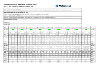
1. General Forecast - Perth, Angus, Aberdeen, Moray Firth
Low cloud and fog in places at first will soon burn back to the coast leaving all inland areas dry, mostly sunny and very warm. Dry overnight with clear periods, but still cloudy and foggy in some coastal regions.
General Forecast - Western Isles, NW & Cent Highlands, Skye, Argyll
Mostly dry, sunny and very warm, although an isolated shower cannot be ruled out cross the NW Highlands. Mostly clear skies overnight.
General Forecast - Shetland, Orkney, NE Caithness
Dry but with a good deal of low cloud and coastal fog in places. Some sunshine is likely to develop in places during the day. Overnight, dry with variable cloud.
Synoptic Discussion and Confidence
High pressure to the north-east of the UK will continue to give dry, settled and very warm weather for much of Scotland. However, a gentle easterly airflow will continue to feed low cloud and fog onto some eastern coasts. High confidence.
Upland Forecast
As lowland forecast
Mean Dir'n Gust Mean Dir'n Gust Mean Dir'n Gust Mean Dir'n Gust Mean Dir'n Gust Mean Dir'n Gust Mean Dir'n Gust Mean Dir'n Gust Mean Dir'n Gust
10 N 15 10 SE 15 10 E 20 10 E 20 10 SE 15 10 E 20 10 SW 20 15 SE 15 10 SE 15
10 SE 20 5 SE 15 10 E 20 10 E 20 10 SE 15 10 E 20 5 NE 20 10 SE 15 10 SE 15
5 N 10 5 N 10 5 NE 15 5 NE 15 5 SE 10 5 NE 15 5 N 10 10 SE 10 5 E 10
5 NE 5 10 N 10 5 E 10 5 E 10 5 SE 10 5 E 10 5 NE 10 10 E 10 5 E 10
Snow
(cm)
Line
Icing
Height
(m)
Snow
(cm)
Line
Icing
Height
(m)
Snow
(cm)
Line
Icing
Height
(m)
Snow
(cm)
Line
Icing
Height
(m)
Snow
(cm)
Line
Icing
Height
(m)
Snow
(cm)
Line
Icing
Height
(m)
Snow
(cm)
Line
Icing
Height
(m)
Snow
(cm)
Line
Icing
Height
(m)
Snow
(cm)
Line
Icing
Height
(m)
0.0 Nil N/A 0.0 Nil N/A 0.0 Nil N/A 0.0 Nil N/A 0.0 Nil N/A 0.0 Nil N/A 0.0 Nil N/A 0.0 Nil N/A 0.0 Nil N/A
Area Perth & Angus Aberdeenshire Moray Firth Argyll & West Highland NW Highland & Skye Central Highlands Western Isles Orkney & NE Caithness Shetland Area
Risk (RAG) Green Green Green Green Green Green Green Green Green Risk (RAG)
Temp
(Max/Min)
26 12 26 11 25 12 26 11 27 11 27 10 21 14 19 11 19 11
Temp
(Max/Min)
Wind Wind
06h-12h 06h-12h
12h-18h 12h-18h
18h-00h 18h-00h
00h-06h 00h-06h
Rain (mm) Rain (mm)
06h-18h 0 - 0 0 - 0 0 - 0 0 - 0 0 - 2.0 0 - 0 0 - 0 0 - 0 0 - 0 06h-18h
18h-06h 0 - 0 0 - 0 0 - 0 0 - 0 0 - 0 0 - 0 0 - 0 0 - 0 0 - 0 18h-06h
Snow/Line
Icing
Snow/Line
Icing
06h-18h 06h-18h
18h-06h 18h-06h
Lightning Lightning
06h-18h 4 4 4 4 3 4 4 4 4 06h-18h
18h-06h 4 4 4 4 4 4 4 4 4 18h-06h
Scheduled Utilities Forecast - SHEPD (North) - Thursday 24 Jul 2014
Day 1 of 5 (0600 Thursday 24th July to 0600 Friday 25th July)
2. General Forecast - Perth, Angus, Aberdeen, Moray Firth
Some low cloud and fog still possible in coastal areas, but otherwise it will be another fine and warm day with sunny periods. Clear periods overnight, but coastal fog still possible.
General Forecast - Western Isles, NW & Cent Highlands, Skye, Argyll
Very warm again with sunny periods, but there is the chance of a few potentially heavy showers developing during the day. Mostly dry overnight with clear periods, but cloud and patchy rain may affect westernmost areas later.
General Forecast - Shetland, Orkney, NE Caithness
Fairly cloudy once again with coastal fog possible, but staying dry with some sunny intervals likely to develop. Overnight, dry but mainly cloudy.
Synoptic Discussion and Confidence
High pressure to the north-est of the UK is expected to gradually decline, but high pressure to the west of the UK will begin to intensify. Mainly dry and settled weather continuing for Scotland. High confidence.
Upland Forecast
As lowland forecast
Mean Dir'n Gust Mean Dir'n Gust Mean Dir'n Gust Mean Dir'n Gust Mean Dir'n Gust Mean Dir'n Gust Mean Dir'n Gust Mean Dir'n Gust Mean Dir'n Gust
10 NE 15 5 NE 15 10 E 10 5 SW 10 10 E 15 5 S 10 5 W 15 10 E 15 10 NE 10
5 NE 15 5 SE 15 10 E 15 5 NW 15 5 SE 15 5 W 15 5 NW 15 10 E 15 10 E 10
5 SW 10 10 S 10 5 NE 10 5 SE 15 5 S 10 5 SW 10 5 W 10 10 SE 15 15 SE 15
5 S 10 10 SE 10 5 S 5 10 SW 10 5 SE 10 5 S 10 5 NE 10 10 SE 10 15 S 15
Snow
(cm)
Line
Icing
Height
(m)
Snow
(cm)
Line
Icing
Height
(m)
Snow
(cm)
Line
Icing
Height
(m)
Snow
(cm)
Line
Icing
Height
(m)
Snow
(cm)
Line
Icing
Height
(m)
Snow
(cm)
Line
Icing
Height
(m)
Snow
(cm)
Line
Icing
Height
(m)
Snow
(cm)
Line
Icing
Height
(m)
Snow
(cm)
Line
Icing
Height
(m)
0.0 Nil N/A 0.0 Nil N/A 0.0 Nil N/A 0.0 Nil N/A 0.0 Nil N/A 0.0 Nil N/A 0.0 Nil N/A 0.0 Nil N/A 0.0 Nil N/A
Area Perth & Angus Aberdeenshire Moray Firth Argyll & West Highland NW Highland & Skye Central Highlands Western Isles Orkney & NE Caithness Shetland Area
Risk (RAG) Green Green Green Green Green Green Green Green Green Risk (RAG)
Temp
(Max/Min)
26 12 23 12 23 12 26 12 26 12 26 12 21 14 17 12 18 12
Temp
(Max/Min)
Wind Wind
06h-12h 06h-12h
12h-18h 12h-18h
18h-00h 18h-00h
00h-06h 00h-06h
Rain (mm) Rain (mm)
06h-18h 0 - 0 0 - 0 0 - 0 0 - 0 0 - 2.0 0 - 2.0 0 - 2.0 0 - 0 0 - 0 06h-18h
18h-06h 0 - 0 0 - 0 0 - 0 0 - 1.0 0 - 0 0 - 0 0.5 - 1.2 0 - 0 0 - 0 18h-06h
Snow/Line
Icing
Snow/Line
Icing
06h-18h 06h-18h
18h-06h 18h-06h
Lightning Lightning
06h-18h 4 4 4 4 3 3 3 4 4 06h-18h
18h-06h 4 4 4 3 4 4 3 4 4 18h-06h
Day 2 of 5 (0600 Friday 25th July to 0600 Saturday 26th July)
3. General Forecast - Perth, Angus, Aberdeen, Moray Firth
A mostly dry and fine morning. Turning cloudy from the west with some showery rain
later in the afternoon. Some of the rain will be heavy during the evening and overnight
with a risk of occasional lightning.
General Forecast - Western Isles, NW & Cent Highlands, Skye, Argyll
Cloud and showery rain will spread from the west, some of the rain heavy with
lightning possible later. Further rain overnight, although it will tend to ease and being
to clear eastwards. Becoming breezy in the west.
General Forecast - Shetland, Orkney, NE Caithness
Fairely cloudy but dry for much of the day. Showery rain will move eastwards during
the evening and overnight, some heavy with lightning possible later.
General Forecast - Perth, Angus, Aberdeen, Moray Firth
Further rain likely during the day, some heavy with a small risk of lightning. Breezy.
Drier overnight.
General Forecast - Western Isles, NW & Cent Highlands, Skye, Argyll
A breezy day with patchy rain during the morning, this mainly in eastern areas. The
rain will tend to ease later. Dry overnight with clear spells.
General Forecast - Shetland, Orkney, NE Caithness
Outbreaks of rain likely during the day, some possibly heavy. It should become drier
overnight. Brisk winds.
General Forecast - Perth, Angus, Aberdeen, Moray Firth
Largely dry with some sunny spells. Cloudier overnight but it should stay dry.
General Forecast - Western Isles, NW & Cent Highlands, Skye, Argyll
A mainly dry day with some sunshine. Patchy rain likely overnight.
General Forecast - Shetland, Orkney, NE Caithness
A dry day with sunny spells. More cloud overnight with rain possible later.
Mean Dir'n Gust Mean Dir'n Gust Mean Dir'n Gust Mean Dir'n Gust Mean Dir'n Gust Mean Dir'n Gust Mean Dir'n Gust Mean Dir'n Gust Mean Dir'n Gust
20 NW 25 20 W 40 20 NW 30 25 N 40 25 N 40 30 NW 45 25 NW 40 20 SW 30 20 NW 25
Snow
(cm)
Line
Icing
Height
(m)
Snow
(cm)
Line
Icing
Height
(m)
Snow
(cm)
Line
Icing
Height
(m)
Snow
(cm)
Line
Icing
Height
(m)
Snow
(cm)
Line
Icing
Height
(m)
Snow
(cm)
Line
Icing
Height
(m)
Snow
(cm)
Line
Icing
Height
(m)
Snow
(cm)
Line
Icing
Height
(m)
Snow
(cm)
Line
Icing
Height
(m)
0.0 Nil N/A 0.0 Nil N/A 0.0 Nil N/A 0.0 Nil N/A 0.0 Nil N/A 0.0 Nil N/A 0.0 Nil N/A 0.0 Nil N/A 0.0 Nil N/A
Day 3 of 5 (0600 Saturday 26th July to 0600 Sunday 27th July) Day 4 of 5 (0600 Sunday 27th July to 0600 Monday 28th July) Day 5 of 5 (0600 Monday 28th July to 0600 Tuesday 29th July)
Area
Day Three Day Four Day Five
Perth, Angus, Aberdeen,
Moray Firth
Western Isles, NW & Cent
Highlands, Skye, Argyll
Shetland, Orkney, NE
Caithness
Perth, Angus, Aberdeen,
Moray Firth
Western Isles, NW & Cent
Highlands, Skye, Argyll
Shetland, Orkney, NE
Caithness
Perth, Angus, Aberdeen,
Moray Firth
Western Isles, NW & Cent
Highlands, Skye, Argyll
Shetland, Orkney, NE
Caithness
Risk
(RAG)
Green Green Green Green Green Green Green Green Green
Temp
(Max/Min)
23 13 23 12 19 12 20 12 18 11 17 12 20 13 20 12 17 11
Wind
24 hours
Rain (mm) 24 hour total 24 hour total 24 hour total 24 hour total 24 hour total 24 hour total 24 hour total 24 hour total 24 hour total
24 hours 6 - 15 3 - 12 1 - 13 5 - 12 2 - 8 4 - 12 0 - 0 0 - 3 0 - 1
Snow/Line
Icing
24 hours
Lightning
24 hours 2C 2C 2C 2D 3 3 4 3 3
Days 6 to 10 (0600 Tuesday 29th July to 0600 Sunday 3rd August)
Outlook
A westerly airflow could bring some rain at times during the early part of next week, but high pressure looks likely to re-establish itself, leading to drier and more settled conditions.
4. Overall risk of disruption
Severe risk Red
Significant risk Amber
No risk Green
The above reflects the worst case of any of the following
Wind Gusts (mph) - 1st November - 31st March
S, SW, W & NW
Islands 50 55 60 65 70 75 80 85 90 95
West Mainland 50 55 60 65 70 75 80 85 90 95
East Mainland 50 55 60 65 70 75 80 85 90 95
N, NE, E & SE
Islands 50 55 60 65 70 75 80 85 90 95
West Mainland 50 55 60 65 70 75 80 85 90 95
East Mainland 50 55 60 65 70 75 80 85 90 95
Wind Gusts (mph) - 1st April - 31st October
S, SW, W & NW
Islands 50 55 60 65 70 75 80 85 90 95
West Mainland 50 55 60 65 70 75 80 85 90 95
East Mainland 50 55 60 65 70 75 80 85 90 95
N, NE, E & SE
Islands 50 55 60 65 70 75 80 85 90 95
West Mainland 50 55 60 65 70 75 80 85 90 95
East Mainland 50 55 60 65 70 75 80 85 90 95
Rainfall (mm)
12 hr (days 1 and 2) 24 hr (days 3 to 5)
>75 >100
>50 >50
<=50 <=50
Snowfall (cm)
12 hr (days 1 and 2) 24 hr (days 3 to 5)
if 24hr total >=10 >=5 >=10
>1 >=5
<=1 <5
if 24hr total >=5 >1
<=1
if 24hr total <5 any amount
Line icing
12 hr (days 1 and 2) 24 hr (days 3 to 5)
Severe Severe
other 12hr > Nil Moderate Moderate
other 12hr = Nil Moderate Slight
Slight Nil
Nil
Lightning risk and disruption colour code matrix
5. Islands Shetland; Orkney & NE Caithness; Western Isles; Cent. Highlands
West Mainland NW Highlands & Skye; Argyll & West
East Mainland Moray Firth; Aberdeenshire; Perth & Angus
Risk level 1 A B C D
Risk level 2 A B C D
Risk level 3 A B C D
Risk level 4 A B C D
Lightning Risk Categories
1 - Lightning will almost certainly occur across the region, or is occurring
2 - Lightning is likely across the region
3 - Lightning is unlikely across the region, although convective activity or an active front is forecast
4 - Lightning is not expected to occur across the region
Lightning Intensity Index
A - Very frequent lightning strikes
B - Frequent lightning strikes
C - Infrequent lightning strikes
D - Very infrequent lightning strikes
All Temperatures in °C
All Wind speeds in MPH