Data Analytics - Rit D4D_senegal_poster_31_december_2014
•
1 like•295 views

Visual Analysis on Call Data Records for Improving Disaster Resilience
Recommended

Recommended
More Related Content
What's hot
What's hot (7)
Similar to Data Analytics - Rit D4D_senegal_poster_31_december_2014
Similar to Data Analytics - Rit D4D_senegal_poster_31_december_2014 (20)
More from Aishwarya Savant
Recently uploaded
Recently uploaded (20)
Data Analytics - Rit D4D_senegal_poster_31_december_2014
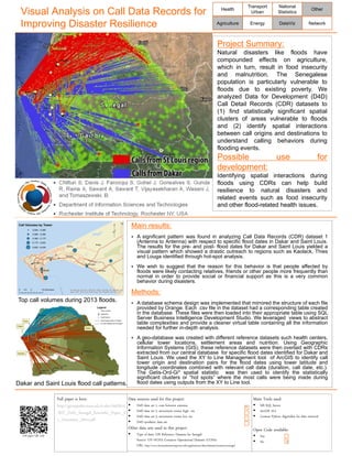
- 1. Main results: A significant pattern was found in analyzing Call Data Records (CDR) dataset 1 (Antenna to Antenna) with respect to specific flood dates in Dakar and Saint Louis. The results for the pre- and post- flood dates for Dakar and Saint Louis yielded a visual pattern which showed a drastic outreach to regions such as Kaolack, Thies and Louga identified through hot-spot analysis. We wish to suggest that the reason for this behavior is that people affected by floods were likely contacting relatives, friends or other people more frequently than normal in order to provide social or financial support as this is a very common behavior during disasters. Methods: A database schema design was implemented that mirrored the structure of each file provided by Orange. Each .csv file in the dataset had a corresponding table created in the database. These files were then loaded into their appropriate table using SQL Server Business Intelligence Development Studio. We leveraged views to abstract table complexities and provide a cleaner virtual table containing all the information needed for further in-depth analysis. A geo-database was created with different reference datasets such health centers, cellular tower locations, settlement areas and nutrition. Using Geographic Information Systems (GIS), these reference datasets were then overlaid with CDRs extracted from our central database for specific flood dates identified for Dakar and Saint Louis. We used the XY to Line Management tool of ArcGIS to identify call tower origin and destination pairs for the flood dates using tower latitude and longitude coordinates combined with relevant call data (duration, call date, etc.). The Getis-Ord-Gi* spatial statistic was then used to identify the statistically significant clusters or “hot spots” where the most calls were being made during flood dates using outputs from the XY to Line tool. Visual Analysis on Call Data Records for Improving Disaster Resilience Project Summary: Natural disasters like floods have compounded effects on agriculture, which in turn, result in food insecurity and malnutrition. The Senegalese population is particularly vulnerable to floods due to existing poverty. We analyzed Data for Development (D4D) Call Detail Records (CDR) datasets to (1) find statistically significant spatial clusters of areas vulnerable to floods and (2) identify spatial interactions between call origins and destinations to understand calling behaviors during flooding events. Possible use for development: Identifying spatial interactions during floods using CDRs can help build resilience to natural disasters and related events such as food insecurity and other flood-related health issues. Chitturi S, Davis J, Farooqui S, Gohel J, Gonsalves S, Gunda R, Raina A, Sawant A, Sawant T, Vijayasekharan A, Wasani J, and Tomaszewski, B. Department of Information Sciences and Technologies Rochester Institute of Technology, Rochester NY, USA. Health Agriculture Transport Urban Energy National Statistics DataViz Other Network Full paper is here: http://geoapps64.main.ad.rit.edu/d4d2014 /RIT_D4D_Senegal_Scientific_Paper_3 1_December_2014.pdf Data sources used for this project: D4D data set 1, com between antenna D4D data set 2, movement routes high res D4D data set 3, movement routes low res D4D synthetic data set Other data sets used in this project: Type of data: GIS Reference Datasets for Senegal Source: UN OCHA Common Operational Datasets (CODs) URL: http://www.humanitarianresponse.info/applications/data/datasets/locations/senegal Main Tools used: MS SQL Server ArcGIS 10.2 Custom Python Algorithm for data retrieval Open Code available: Yes No Place a high resolution picture here Top call volumes during 2013 floods. Dakar and Saint Louis flood call patterns. x x X X Full paper QR code