rinhs science 9 3rd quiz 2 weather and climate.docx
•Download as DOCX, PDF•
0 likes•8 views
test
Report
Share
Report
Share

Recommended
longQuizfactorsaffectingclimate......pptx
This document contains a quiz about weather and climate concepts. It includes multiple choice and true/false questions about how factors like latitude, altitude, proximity to large bodies of water and topography influence climate. Key ideas covered are that temperature generally decreases with increased altitude or latitude from the equator, while topographic features like mountains can create rain shadows on their leeward sides with drier conditions.
Weather and Climate
Meteorologists study weather and use weather data to predict conditions. Weather is the current atmospheric conditions of an area, including factors like temperature, wind, and precipitation. Climate is the average weather of a region over a long period of time. Weather instruments and satellites provide accurate weather information that helps meteorologists make forecasts to inform public planning.
powerpoint climate for my CO.ppt
The document discusses factors that affect climate, including latitude. It differentiates between weather, which describes short-term atmospheric conditions, and climate, which refers to long-term patterns. An activity asks students to identify statements as referring to weather or climate. Examples show weather in Manila and climate in Metro Manila. Places are classified into tropical, temperate, and polar regions based on location. Questions cover how the tilt of Earth's axis and latitude impact the amount of sunlight and heat received in different areas, affecting regional climates.
Factors affecting climate
This document contains information about various climate factors and a series of assessment questions. It discusses how latitude, altitude, distance from bodies of water, air pressure systems, mountain barriers, elevation, continental location, wind belts, ocean currents, and storms can all impact the climate of a given region. Several diagrams and tables are included to illustrate these concepts. Students are asked to identify which cities would have the highest and lowest recorded temperatures based on their locations, and to explain how ocean currents can influence climate conditions.
Chapter 17 – meteorology
Meteorologists use various data sources to predict the weather, but it is difficult to always be correct due to rapidly changing atmospheric conditions. Data comes from surface weather stations, weather balloons, satellites, radars, and computer models. Air masses and fronts influence weather by interacting and creating storms. Hurricanes form over warm ocean waters and require specific atmospheric ingredients. While high and low pressure systems impact weather, small changes in data can lead to different model predictions, making weather forecasting challenging.
Chapter 17 – meteorology
Meteorologists use various data sources to predict the weather, but it is difficult to always be correct due to rapidly changing atmospheric conditions. Data comes from surface weather stations, weather balloons, satellites, radars, and computer models. Air masses and fronts influence weather, and storms form when different air masses meet. Hurricanes require specific conditions like warm ocean water. While meteorology studies the atmosphere, tiny differences in data can lead to different model results, so multiple models are used to predict daily weather.
Weekly-Assessment-No.-6.docx
This document is a science assessment for 8th grade students on the topic of understanding typhoons. It contains 20 multiple choice questions testing students' knowledge of typhoons, including which government agency monitors them in the Philippines, where they form, examples of powerful recent typhoons, typhoon warning signals and their impacts, conditions needed for formation, and anatomy of a typhoon. Students are instructed to select the best answer for each question.
Weather-Part-II.pdf
- Climate refers to the average weather conditions in an area over a long period of time, while weather describes the short-term conditions.
- There are three main climate zones: tropical near the equator, temperate between the equator and poles, and polar near the North and South poles.
- Factors like a region's location, nearby air masses, proximity to bodies of water, and elevation can determine whether its climate is more tropical, temperate, or polar.
LATITUDE.powerpoint presention documents
This powerful PowerPoint presentation is made by a graduating student that pushes her study even more because she believe that while doing something she loves, it can be easy for them to study and to strive even more for their studies
SCIENCE 8
This lesson plan covers the formation and development of typhoons. It includes objectives, content understanding, learning resources, activities to engage students, and an assessment. Students will learn that typhoons form from warm, moist air rising over the ocean and condensing into clouds and rainfall. As more warm air rises to replace the air that formed the clouds, winds begin to circulate, potentially strengthening into a typhoon. The lesson uses videos, diagrams, and questions to help students understand the factors and step-by-step process of how typhoons form and develop.
Unit 3. Weather and climate
This document provides information about the atmosphere and weather/climate concepts. It is divided into 5 sections:
1. Describes the composition of the atmosphere and its main layers, including the troposphere where weather occurs and the stratosphere containing the ozone layer.
2. Defines weather as short-term atmospheric conditions and climate as long-term patterns. Students are asked to describe the weather in their town.
3. Explains elements that influence climate - temperature, precipitation, air pressure, and wind. It describes factors affecting temperature and different climate zones.
4. Discusses precipitation, including types of rainfall. Factors like latitude and altitude are outlined.
5. Covers
1 LAB MODULE 5 GLOBAL TEMPERATURE PATTERNS Note P
1
LAB MODULE 5: GLOBAL TEMPERATURE PATTERNS
Note: Please refer to the GETTING STARTED lab module to learn how to maneuver
through and answer the lab questions using the Google Earth ( ) component.
KEY TERMS
You should know and understand the following terms:
Air temperature Heat index Temperature anomalies
Altitude Kelvin (K) Temperature averages
Ambient temperature Latitude Thermopause
Axial Tilt Maritime effect Thermosphere
Celsius (C) Mesopause Tropopause
Continentality, or
Continental effect
Mesosphere Troposphere
Stratopause Urban heat island
Environmental Lapse Rate Stratosphere Urban heat island effect
Exosphere Structure of the atmosphere Wind chill
Fahrenheit (F) Surface temperature
LAB MODULE LEARNING OBJECTIVES
After successfully completing this module, you should be able to the following
tasks:
Describe the differences between air and surface temperature
Explain heat index and wind chill
Explain the urban heat island effect
Describe the structure of the atmosphere
Describe large scale factors influencing temperature
Describe local factors influencing temperature
2
INTRODUCTION
This lab module explores the global surface and air temperatures of Earth and
Earth’s atmosphere. Topics include the structure of the atmosphere, local and
global factors influencing temperature, and temperature anomalies. The modules
start with four opening topics, or vignettes, which are found in the accompanying
Google Earth file. These vignettes introduce basic concepts of the internal structure
of the Earth. Some of the vignettes have animations, videos, or short articles that
will provide another perspective or visual explanation for the topic at hand. After
reading the vignette and associated links, answer the following questions. Please
note that some links might take a while to download based on your Internet speed.
Expand the INTRODUCTION folder.
Read Topic 1: Surface and Air Temperature
Question 1: How do the surface temperatures of the countries in the
northern latitudes (for example, Canada, Iceland, Norway, and Russia)
compare to those of northern Africa (for example, Algeria, Egypt, Libya,
Morocco, and Sudan)?
A. The temperatures are higher in the northern latitudes during summer
months when net radiation is higher.
B. The temperatures are lower in north Africa during the summer months
when net radiation is higher in northern latitudes.
C. Temperatures are lower in northern latitudes year-round.
D. Temperatures are only lower in the northern latitudes during winter
months.
Read Topic 2: Measuring Temperature
Question 2: Considering water freezes (or alternatively, melts) at 0˚C,
determine from the map which countries or landmasses have an annual
mean temperature around 0˚C.
A. Canada and Norway
B. The United States and the United Kingdom
C. Greenland and Antarctica
D. Russia and Antarctica
3
...
Geography Cheet Sheet.docx
The document provides information about geography, weather, climate and their related concepts. It defines key terms like weather, climate, precipitation and clouds. It describes the formation of clouds and precipitation. It also explains factors that influence weather and climate such as latitude, altitude, winds, temperature etc. Measurement instruments for different weather elements are defined. The three main thermal zones of the earth are described along with how various geographic factors affect temperature.
Science Summer Course - Weather and Atmosphere
Science Summer Course - Weather and Atmosphere
- Basic concepts in learning the layers of atmosphere and the weather
Unit 5
The document discusses the key topics that will be covered in the second term of a geography course. It includes six units: Unit 5 on the atmosphere, weather, and climate; Unit 6 on Earth's biomes; and Unit 1 on prehistory. For Unit 5, there will be photocopies, a presentation, and optional weather forecasting activities. Unit 6 will involve cooperative work and an activity on biomes in Spain. An exam on Units 5-6 will take place on February 22, 2019.
Science Five, Periodical Exam Second Quarter
This document contains a 50-item multiple choice test on science and health topics such as weathering, erosion, typhoons, the moon's phases, and stars. The test questions cover processes like physical and chemical weathering, erosion by water and wind, effects of typhoons, characteristics of the moon's phases, and features of constellations. It is intended for a 5th grade science class in the Philippines to assess their understanding of various earth and space science concepts.
Unit 5
The document provides information about the key concepts that will be covered in the second term of a geography course. It includes six units of study: Unit 5 on the atmosphere, weather, and climate; Unit 6 on Earth's biomes; and Unit 1 on prehistory. For Unit 5, the document outlines the key topics that will be covered, including the layers of the atmosphere, the properties of air, atmospheric dynamics, weather factors, the Earth's climates and climate zones, and climates of Spain. Interactive exercises and a climograph activity are also mentioned.
STR581 Strategic Planning & ImplementationWk 5 - Signature Ass.docx
STR/581: Strategic Planning & Implementation
Wk 5 - Signature Assignment: Strategic Plan - Implementation Plan, Strategic Controls, and Contingency Plan Analysis
Top of Form
About Your Signature Assignment
This signature assignment is designed to align with specific program student learning outcome(s) in your program. Program Student Learning Outcomes are broad statements that describe what students should know and be able to do upon completion of their degree. The signature assignments may be graded with an automated rubric that allows the University to collect data that can be aggregated across a location or college/school and used for program improvements.
Write a 1,050-word minimum strategic implementation plan in which you include the following:
· Create an implementation plan including:
· Objectives
· Functional tactics
· Action items
· Milestones and deadlines
· Tasks and task ownership
· Resource allocation
· Recommend any organizational change management strategies that may enhance successful implementation.
· Develop key success factors, budget, and forecasted financials, including a break-even chart.
· Create a risk management plan including contingency plans for the identified risks.
Format your paper according to APA guidelines.
Physical Exam #4 Your Name: ____________________________ _____
____1. If air's capacity for holding water vapor is diminished, then the relative humidity will _____. 48
A) rise B) fall C) be unchanged D) double E) none of the above
____2. In the atmosphere, liquid water collects around minute particles called ________. A) condensation nuclei B) raindrops C) fog D) cloud droplets E) ice crystals
____3. Clouds form if air is ________.
A) cooled to the dew point B) below freezing C) stable D) unstable E) windy
____4. Among cloud types, those that occur at the highest altitudes are the ________. A) cumulus
B) altocumulus C) stratus D) cirrus E) stratocumulus
____5. Which of the following is most closely associated with stable air?
A) very moist air B) cooling of rising air C) rising air D) fast wind speeds in the air E) descent of air
____6. Showery weather and cumuliform clouds point to the presence of ____. A) orographic lift of air B) anticyclonic descent of air C) instability D) relatively few condensation nuclei E) atmospheric equilibrium
____7. Downwind of large mountain ranges there is less precipitation; this drier zone is called the ________.
A) windward side B) rain shadow C) advection side D) adiabatic area E) lifting condensation level
____8. A midlatitude anticyclone ____ A) is more than one air mass B) exhibits instability C) has a front in its center D) is associated with fast winds E) is associated with sunny, dry weather
____9. Which of the following is NOT NECESSARILY a property of an air mass? A) It must be large. B) It must have relatively uniform properties within itself. C) It must have a warm front at its leading edge. D) .
Weather Quiz #2
This document contains a 10 question weather quiz about air masses, fronts, and weather patterns. The quiz questions cover topics like how studying weather maps helps scientists, the definition of a front, how temperature is affected during cold and warm fronts, types of weather associated with high and low pressure systems, typical weather conditions during hurricanes, the coldest season in North Carolina, the most common precipitation in North Carolina, identifying fair weather based on descriptions, which front type brings prolonged clouds and precipitation, and predicting weather when a cold air mass interacts with a warm air mass. The answers to the 10 multiple choice questions are provided at the end.
first quarterly assessment in science,tle,science 8 2023.docx
1) This document contains a 50-item multiple choice science examination on geology and plate tectonics for 10th grade students in the Philippines.
2) The exam covers topics like earthquake and tsunami safety procedures, plate tectonics theory, characteristics of convergent, divergent and transform plate boundaries, and geological features associated with plate tectonics like volcanoes, mountain ranges, and faults.
3) The exam was prepared by a Teacher III and checked by the Teacher-in-Charge for the Schools Division of Oriental Mindoro in the Philippines.
SCI7 Q4 MOD1.pdf
Here are the correct words that fit in each sentence:
Currently, Earth is composed of seven continents surrounded by different
bodies of water. Locating a specific place would not be possible if not for Earth’s
models such as maps and globes. A map is a two-dimensional drawing which
can be used on flat surfaces and is easily carried. On the other hand, a globe is a three-dimensional representation of the spherical shape of Earth. A unique
feature of a globe is Earth’s tilt with respect to its North and South Poles. It also
represents Earth’s position relative to Sun
1. Integrate theoretical knowledge acquired through the stud.docx
1.
Integrate theoretical knowledge acquired through the study of normal and pathological processes in the care of adult and older adult clients experiencing illness and disease.
(FYI can you please pick either IV therapy, indwelling catheter ,specimen collection, oxygen therapy ,central line dressing, NG tube, . tube feeding or any clinical activities that happen in a nursing home.) A nursing home is normally the highest level of care for older adults outside of a hospital. Its is normally run by RN nurses, LPN and CNA, the Doctors in NURSING HOME are usually on call.
Section B
Clinical Observation Experience Summary
I. Date of Observation:
II. Location of Observation:
III. Hours completed for this Observation:
IV. Type of Observation:
V. Preceptor Name and Contact Information:
VI. Objectives met:
VII. Observed Roles:
VIII. Description of clinical experience and skills practiced:
IX. Reflection of the quality and value of the experience:
Reference….
1
LAB MODULE 5: GLOBAL TEMPERATURE PATTERNS
Note: Please refer to the GETTING STARTED lab module to learn how to maneuver
through and answer the lab questions using the Google Earth ( ) component.
KEY TERMS
You should know and understand the following terms:
Air temperature Heat index Temperature anomalies
Altitude Kelvin (K) Temperature averages
Ambient temperature Latitude Thermopause
Axial Tilt Maritime effect Thermosphere
Celsius (C) Mesopause Tropopause
Continentality, or
Continental effect
Mesosphere Troposphere
Stratopause Urban heat island
Environmental Lapse Rate Stratosphere Urban heat island effect
Exosphere Structure of the atmosphere Wind chill
Fahrenheit (F) Surface temperature
LAB MODULE LEARNING OBJECTIVES
After successfully completing this module, you should be able to the following
tasks:
Describe the differences between air and surface temperature
Explain heat index and wind chill
Explain the urban heat island effect
Describe the structure of the atmosphere
Describe large scale factors influencing temperature
Describe local factors influencing temperature
2
INTRODUCTION
This lab module explores the global surface and air temperatures of Earth and
Earth’s atmosphere. Topics include the structure of the atmosphere, local and
global factors influencing temperature, and temperature anomalies. The modules
start with four opening topics, or vignettes, which are found in the accompanying
Google Earth file. These vignettes introduce basic concepts of the internal structure
of the Earth. Some of the vignettes have animations, videos, or short articles that
will provide another perspective or visual explanation for the topic at hand. After
reading the vignette and associated links, answer the following questions. Please
note that some links might take a while to download bas.
lecture and activity.pptx
Altitude affects climate such that higher altitude means colder temperatures. As elevation increases, atmospheric temperature decreases at a normal rate of 1°C for every 100 meters gained in elevation. Mountain climbers wear thick clothes at higher elevations because temperature decreases as altitude increases due to thinner air.
SCI7 Q4 MOD4.pdf
1. The document is a science module that discusses atmospheric phenomena such as breezes, monsoons, and the Intertropical Convergence Zone (ITCZ).
2. It contains two lessons - the first discusses the behavior of heated air and surrounding air, including demonstrations that heated air rises due to lower density. The second lesson explains atmospheric phenomena.
3. Activities include comparing how fast sand and water warm up when exposed to sunlight, demonstrating rising warm air using a paper bag and candle, and showing air movement inside and outside a box with a lighted candle and smoke from a mosquito coil.
1. Integrate theoretical knowledge acquired through the stud
1.
Integrate theoretical knowledge acquired through the study of normal and pathological processes in the care of adult and older adult clients experiencing illness and disease.
(FYI can you please pick either IV therapy, indwelling catheter ,specimen collection, oxygen therapy ,central line dressing, NG tube, . tube feeding or any clinical activities that happen in a nursing home.) A nursing home is normally the highest level of care for older adults outside of a hospital. Its is normally run by RN nurses, LPN and CNA, the Doctors in NURSING HOME are usually on call.
Section B
Clinical Observation Experience Summary
I. Date of Observation:
II. Location of Observation:
III. Hours completed for this Observation:
IV. Type of Observation:
V. Preceptor Name and Contact Information:
VI. Objectives met:
VII. Observed Roles:
VIII. Description of clinical experience and skills practiced:
IX. Reflection of the quality and value of the experience:
Reference….
1
LAB MODULE 5: GLOBAL TEMPERATURE PATTERNS
Note: Please refer to the GETTING STARTED lab module to learn how to maneuver
through and answer the lab questions using the Google Earth ( ) component.
KEY TERMS
You should know and understand the following terms:
Air temperature Heat index Temperature anomalies
Altitude Kelvin (K) Temperature averages
Ambient temperature Latitude Thermopause
Axial Tilt Maritime effect Thermosphere
Celsius (C) Mesopause Tropopause
Continentality, or
Continental effect
Mesosphere Troposphere
Stratopause Urban heat island
Environmental Lapse Rate Stratosphere Urban heat island effect
Exosphere Structure of the atmosphere Wind chill
Fahrenheit (F) Surface temperature
LAB MODULE LEARNING OBJECTIVES
After successfully completing this module, you should be able to the following
tasks:
Describe the differences between air and surface temperature
Explain heat index and wind chill
Explain the urban heat island effect
Describe the structure of the atmosphere
Describe large scale factors influencing temperature
Describe local factors influencing temperature
2
INTRODUCTION
This lab module explores the global surface and air temperatures of Earth and
Earth’s atmosphere. Topics include the structure of the atmosphere, local and
global factors influencing temperature, and temperature anomalies. The modules
start with four opening topics, or vignettes, which are found in the accompanying
Google Earth file. These vignettes introduce basic concepts of the internal structure
of the Earth. Some of the vignettes have animations, videos, or short articles that
will provide another perspective or visual explanation for the topic at hand. After
reading the vignette and associated links, answer the following questions. Please
note that some links might take a while to download bas ...
More Related Content
Similar to rinhs science 9 3rd quiz 2 weather and climate.docx
Weather-Part-II.pdf
- Climate refers to the average weather conditions in an area over a long period of time, while weather describes the short-term conditions.
- There are three main climate zones: tropical near the equator, temperate between the equator and poles, and polar near the North and South poles.
- Factors like a region's location, nearby air masses, proximity to bodies of water, and elevation can determine whether its climate is more tropical, temperate, or polar.
LATITUDE.powerpoint presention documents
This powerful PowerPoint presentation is made by a graduating student that pushes her study even more because she believe that while doing something she loves, it can be easy for them to study and to strive even more for their studies
SCIENCE 8
This lesson plan covers the formation and development of typhoons. It includes objectives, content understanding, learning resources, activities to engage students, and an assessment. Students will learn that typhoons form from warm, moist air rising over the ocean and condensing into clouds and rainfall. As more warm air rises to replace the air that formed the clouds, winds begin to circulate, potentially strengthening into a typhoon. The lesson uses videos, diagrams, and questions to help students understand the factors and step-by-step process of how typhoons form and develop.
Unit 3. Weather and climate
This document provides information about the atmosphere and weather/climate concepts. It is divided into 5 sections:
1. Describes the composition of the atmosphere and its main layers, including the troposphere where weather occurs and the stratosphere containing the ozone layer.
2. Defines weather as short-term atmospheric conditions and climate as long-term patterns. Students are asked to describe the weather in their town.
3. Explains elements that influence climate - temperature, precipitation, air pressure, and wind. It describes factors affecting temperature and different climate zones.
4. Discusses precipitation, including types of rainfall. Factors like latitude and altitude are outlined.
5. Covers
1 LAB MODULE 5 GLOBAL TEMPERATURE PATTERNS Note P
1
LAB MODULE 5: GLOBAL TEMPERATURE PATTERNS
Note: Please refer to the GETTING STARTED lab module to learn how to maneuver
through and answer the lab questions using the Google Earth ( ) component.
KEY TERMS
You should know and understand the following terms:
Air temperature Heat index Temperature anomalies
Altitude Kelvin (K) Temperature averages
Ambient temperature Latitude Thermopause
Axial Tilt Maritime effect Thermosphere
Celsius (C) Mesopause Tropopause
Continentality, or
Continental effect
Mesosphere Troposphere
Stratopause Urban heat island
Environmental Lapse Rate Stratosphere Urban heat island effect
Exosphere Structure of the atmosphere Wind chill
Fahrenheit (F) Surface temperature
LAB MODULE LEARNING OBJECTIVES
After successfully completing this module, you should be able to the following
tasks:
Describe the differences between air and surface temperature
Explain heat index and wind chill
Explain the urban heat island effect
Describe the structure of the atmosphere
Describe large scale factors influencing temperature
Describe local factors influencing temperature
2
INTRODUCTION
This lab module explores the global surface and air temperatures of Earth and
Earth’s atmosphere. Topics include the structure of the atmosphere, local and
global factors influencing temperature, and temperature anomalies. The modules
start with four opening topics, or vignettes, which are found in the accompanying
Google Earth file. These vignettes introduce basic concepts of the internal structure
of the Earth. Some of the vignettes have animations, videos, or short articles that
will provide another perspective or visual explanation for the topic at hand. After
reading the vignette and associated links, answer the following questions. Please
note that some links might take a while to download based on your Internet speed.
Expand the INTRODUCTION folder.
Read Topic 1: Surface and Air Temperature
Question 1: How do the surface temperatures of the countries in the
northern latitudes (for example, Canada, Iceland, Norway, and Russia)
compare to those of northern Africa (for example, Algeria, Egypt, Libya,
Morocco, and Sudan)?
A. The temperatures are higher in the northern latitudes during summer
months when net radiation is higher.
B. The temperatures are lower in north Africa during the summer months
when net radiation is higher in northern latitudes.
C. Temperatures are lower in northern latitudes year-round.
D. Temperatures are only lower in the northern latitudes during winter
months.
Read Topic 2: Measuring Temperature
Question 2: Considering water freezes (or alternatively, melts) at 0˚C,
determine from the map which countries or landmasses have an annual
mean temperature around 0˚C.
A. Canada and Norway
B. The United States and the United Kingdom
C. Greenland and Antarctica
D. Russia and Antarctica
3
...
1 LAB MODULE 5 GLOBAL TEMPERATURE PATTERNS Note P
1
LAB MODULE 5: GLOBAL TEMPERATURE PATTERNS
Note: Please refer to the GETTING STARTED lab module to learn how to maneuver
through and answer the lab questions using the Google Earth ( ) component.
KEY TERMS
You should know and understand the following terms:
Air temperature Heat index Temperature anomalies
Altitude Kelvin (K) Temperature averages
Ambient temperature Latitude Thermopause
Axial Tilt Maritime effect Thermosphere
Celsius (C) Mesopause Tropopause
Continentality, or
Continental effect
Mesosphere Troposphere
Stratopause Urban heat island
Environmental Lapse Rate Stratosphere Urban heat island effect
Exosphere Structure of the atmosphere Wind chill
Fahrenheit (F) Surface temperature
LAB MODULE LEARNING OBJECTIVES
After successfully completing this module, you should be able to the following
tasks:
Describe the differences between air and surface temperature
Explain heat index and wind chill
Explain the urban heat island effect
Describe the structure of the atmosphere
Describe large scale factors influencing temperature
Describe local factors influencing temperature
2
INTRODUCTION
This lab module explores the global surface and air temperatures of Earth and
Earth’s atmosphere. Topics include the structure of the atmosphere, local and
global factors influencing temperature, and temperature anomalies. The modules
start with four opening topics, or vignettes, which are found in the accompanying
Google Earth file. These vignettes introduce basic concepts of the internal structure
of the Earth. Some of the vignettes have animations, videos, or short articles that
will provide another perspective or visual explanation for the topic at hand. After
reading the vignette and associated links, answer the following questions. Please
note that some links might take a while to download based on your Internet speed.
Expand the INTRODUCTION folder.
Read Topic 1: Surface and Air Temperature
Question 1: How do the surface temperatures of the countries in the
northern latitudes (for example, Canada, Iceland, Norway, and Russia)
compare to those of northern Africa (for example, Algeria, Egypt, Libya,
Morocco, and Sudan)?
A. The temperatures are higher in the northern latitudes during summer
months when net radiation is higher.
B. The temperatures are lower in north Africa during the summer months
when net radiation is higher in northern latitudes.
C. Temperatures are lower in northern latitudes year-round.
D. Temperatures are only lower in the northern latitudes during winter
months.
Read Topic 2: Measuring Temperature
Question 2: Considering water freezes (or alternatively, melts) at 0˚C,
determine from the map which countries or landmasses have an annual
mean temperature around 0˚C.
A. Canada and Norway
B. The United States and the United Kingdom
C. Greenland and Antarctica
D. Russia and Antarctica
3
...
Geography Cheet Sheet.docx
The document provides information about geography, weather, climate and their related concepts. It defines key terms like weather, climate, precipitation and clouds. It describes the formation of clouds and precipitation. It also explains factors that influence weather and climate such as latitude, altitude, winds, temperature etc. Measurement instruments for different weather elements are defined. The three main thermal zones of the earth are described along with how various geographic factors affect temperature.
Science Summer Course - Weather and Atmosphere
Science Summer Course - Weather and Atmosphere
- Basic concepts in learning the layers of atmosphere and the weather
Unit 5
The document discusses the key topics that will be covered in the second term of a geography course. It includes six units: Unit 5 on the atmosphere, weather, and climate; Unit 6 on Earth's biomes; and Unit 1 on prehistory. For Unit 5, there will be photocopies, a presentation, and optional weather forecasting activities. Unit 6 will involve cooperative work and an activity on biomes in Spain. An exam on Units 5-6 will take place on February 22, 2019.
Science Five, Periodical Exam Second Quarter
This document contains a 50-item multiple choice test on science and health topics such as weathering, erosion, typhoons, the moon's phases, and stars. The test questions cover processes like physical and chemical weathering, erosion by water and wind, effects of typhoons, characteristics of the moon's phases, and features of constellations. It is intended for a 5th grade science class in the Philippines to assess their understanding of various earth and space science concepts.
Unit 5
The document provides information about the key concepts that will be covered in the second term of a geography course. It includes six units of study: Unit 5 on the atmosphere, weather, and climate; Unit 6 on Earth's biomes; and Unit 1 on prehistory. For Unit 5, the document outlines the key topics that will be covered, including the layers of the atmosphere, the properties of air, atmospheric dynamics, weather factors, the Earth's climates and climate zones, and climates of Spain. Interactive exercises and a climograph activity are also mentioned.
STR581 Strategic Planning & ImplementationWk 5 - Signature Ass.docx
STR/581: Strategic Planning & Implementation
Wk 5 - Signature Assignment: Strategic Plan - Implementation Plan, Strategic Controls, and Contingency Plan Analysis
Top of Form
About Your Signature Assignment
This signature assignment is designed to align with specific program student learning outcome(s) in your program. Program Student Learning Outcomes are broad statements that describe what students should know and be able to do upon completion of their degree. The signature assignments may be graded with an automated rubric that allows the University to collect data that can be aggregated across a location or college/school and used for program improvements.
Write a 1,050-word minimum strategic implementation plan in which you include the following:
· Create an implementation plan including:
· Objectives
· Functional tactics
· Action items
· Milestones and deadlines
· Tasks and task ownership
· Resource allocation
· Recommend any organizational change management strategies that may enhance successful implementation.
· Develop key success factors, budget, and forecasted financials, including a break-even chart.
· Create a risk management plan including contingency plans for the identified risks.
Format your paper according to APA guidelines.
Physical Exam #4 Your Name: ____________________________ _____
____1. If air's capacity for holding water vapor is diminished, then the relative humidity will _____. 48
A) rise B) fall C) be unchanged D) double E) none of the above
____2. In the atmosphere, liquid water collects around minute particles called ________. A) condensation nuclei B) raindrops C) fog D) cloud droplets E) ice crystals
____3. Clouds form if air is ________.
A) cooled to the dew point B) below freezing C) stable D) unstable E) windy
____4. Among cloud types, those that occur at the highest altitudes are the ________. A) cumulus
B) altocumulus C) stratus D) cirrus E) stratocumulus
____5. Which of the following is most closely associated with stable air?
A) very moist air B) cooling of rising air C) rising air D) fast wind speeds in the air E) descent of air
____6. Showery weather and cumuliform clouds point to the presence of ____. A) orographic lift of air B) anticyclonic descent of air C) instability D) relatively few condensation nuclei E) atmospheric equilibrium
____7. Downwind of large mountain ranges there is less precipitation; this drier zone is called the ________.
A) windward side B) rain shadow C) advection side D) adiabatic area E) lifting condensation level
____8. A midlatitude anticyclone ____ A) is more than one air mass B) exhibits instability C) has a front in its center D) is associated with fast winds E) is associated with sunny, dry weather
____9. Which of the following is NOT NECESSARILY a property of an air mass? A) It must be large. B) It must have relatively uniform properties within itself. C) It must have a warm front at its leading edge. D) .
Weather Quiz #2
This document contains a 10 question weather quiz about air masses, fronts, and weather patterns. The quiz questions cover topics like how studying weather maps helps scientists, the definition of a front, how temperature is affected during cold and warm fronts, types of weather associated with high and low pressure systems, typical weather conditions during hurricanes, the coldest season in North Carolina, the most common precipitation in North Carolina, identifying fair weather based on descriptions, which front type brings prolonged clouds and precipitation, and predicting weather when a cold air mass interacts with a warm air mass. The answers to the 10 multiple choice questions are provided at the end.
first quarterly assessment in science,tle,science 8 2023.docx
1) This document contains a 50-item multiple choice science examination on geology and plate tectonics for 10th grade students in the Philippines.
2) The exam covers topics like earthquake and tsunami safety procedures, plate tectonics theory, characteristics of convergent, divergent and transform plate boundaries, and geological features associated with plate tectonics like volcanoes, mountain ranges, and faults.
3) The exam was prepared by a Teacher III and checked by the Teacher-in-Charge for the Schools Division of Oriental Mindoro in the Philippines.
SCI7 Q4 MOD1.pdf
Here are the correct words that fit in each sentence:
Currently, Earth is composed of seven continents surrounded by different
bodies of water. Locating a specific place would not be possible if not for Earth’s
models such as maps and globes. A map is a two-dimensional drawing which
can be used on flat surfaces and is easily carried. On the other hand, a globe is a three-dimensional representation of the spherical shape of Earth. A unique
feature of a globe is Earth’s tilt with respect to its North and South Poles. It also
represents Earth’s position relative to Sun
1. Integrate theoretical knowledge acquired through the stud.docx
1.
Integrate theoretical knowledge acquired through the study of normal and pathological processes in the care of adult and older adult clients experiencing illness and disease.
(FYI can you please pick either IV therapy, indwelling catheter ,specimen collection, oxygen therapy ,central line dressing, NG tube, . tube feeding or any clinical activities that happen in a nursing home.) A nursing home is normally the highest level of care for older adults outside of a hospital. Its is normally run by RN nurses, LPN and CNA, the Doctors in NURSING HOME are usually on call.
Section B
Clinical Observation Experience Summary
I. Date of Observation:
II. Location of Observation:
III. Hours completed for this Observation:
IV. Type of Observation:
V. Preceptor Name and Contact Information:
VI. Objectives met:
VII. Observed Roles:
VIII. Description of clinical experience and skills practiced:
IX. Reflection of the quality and value of the experience:
Reference….
1
LAB MODULE 5: GLOBAL TEMPERATURE PATTERNS
Note: Please refer to the GETTING STARTED lab module to learn how to maneuver
through and answer the lab questions using the Google Earth ( ) component.
KEY TERMS
You should know and understand the following terms:
Air temperature Heat index Temperature anomalies
Altitude Kelvin (K) Temperature averages
Ambient temperature Latitude Thermopause
Axial Tilt Maritime effect Thermosphere
Celsius (C) Mesopause Tropopause
Continentality, or
Continental effect
Mesosphere Troposphere
Stratopause Urban heat island
Environmental Lapse Rate Stratosphere Urban heat island effect
Exosphere Structure of the atmosphere Wind chill
Fahrenheit (F) Surface temperature
LAB MODULE LEARNING OBJECTIVES
After successfully completing this module, you should be able to the following
tasks:
Describe the differences between air and surface temperature
Explain heat index and wind chill
Explain the urban heat island effect
Describe the structure of the atmosphere
Describe large scale factors influencing temperature
Describe local factors influencing temperature
2
INTRODUCTION
This lab module explores the global surface and air temperatures of Earth and
Earth’s atmosphere. Topics include the structure of the atmosphere, local and
global factors influencing temperature, and temperature anomalies. The modules
start with four opening topics, or vignettes, which are found in the accompanying
Google Earth file. These vignettes introduce basic concepts of the internal structure
of the Earth. Some of the vignettes have animations, videos, or short articles that
will provide another perspective or visual explanation for the topic at hand. After
reading the vignette and associated links, answer the following questions. Please
note that some links might take a while to download bas.
lecture and activity.pptx
Altitude affects climate such that higher altitude means colder temperatures. As elevation increases, atmospheric temperature decreases at a normal rate of 1°C for every 100 meters gained in elevation. Mountain climbers wear thick clothes at higher elevations because temperature decreases as altitude increases due to thinner air.
SCI7 Q4 MOD4.pdf
1. The document is a science module that discusses atmospheric phenomena such as breezes, monsoons, and the Intertropical Convergence Zone (ITCZ).
2. It contains two lessons - the first discusses the behavior of heated air and surrounding air, including demonstrations that heated air rises due to lower density. The second lesson explains atmospheric phenomena.
3. Activities include comparing how fast sand and water warm up when exposed to sunlight, demonstrating rising warm air using a paper bag and candle, and showing air movement inside and outside a box with a lighted candle and smoke from a mosquito coil.
1. Integrate theoretical knowledge acquired through the stud
1.
Integrate theoretical knowledge acquired through the study of normal and pathological processes in the care of adult and older adult clients experiencing illness and disease.
(FYI can you please pick either IV therapy, indwelling catheter ,specimen collection, oxygen therapy ,central line dressing, NG tube, . tube feeding or any clinical activities that happen in a nursing home.) A nursing home is normally the highest level of care for older adults outside of a hospital. Its is normally run by RN nurses, LPN and CNA, the Doctors in NURSING HOME are usually on call.
Section B
Clinical Observation Experience Summary
I. Date of Observation:
II. Location of Observation:
III. Hours completed for this Observation:
IV. Type of Observation:
V. Preceptor Name and Contact Information:
VI. Objectives met:
VII. Observed Roles:
VIII. Description of clinical experience and skills practiced:
IX. Reflection of the quality and value of the experience:
Reference….
1
LAB MODULE 5: GLOBAL TEMPERATURE PATTERNS
Note: Please refer to the GETTING STARTED lab module to learn how to maneuver
through and answer the lab questions using the Google Earth ( ) component.
KEY TERMS
You should know and understand the following terms:
Air temperature Heat index Temperature anomalies
Altitude Kelvin (K) Temperature averages
Ambient temperature Latitude Thermopause
Axial Tilt Maritime effect Thermosphere
Celsius (C) Mesopause Tropopause
Continentality, or
Continental effect
Mesosphere Troposphere
Stratopause Urban heat island
Environmental Lapse Rate Stratosphere Urban heat island effect
Exosphere Structure of the atmosphere Wind chill
Fahrenheit (F) Surface temperature
LAB MODULE LEARNING OBJECTIVES
After successfully completing this module, you should be able to the following
tasks:
Describe the differences between air and surface temperature
Explain heat index and wind chill
Explain the urban heat island effect
Describe the structure of the atmosphere
Describe large scale factors influencing temperature
Describe local factors influencing temperature
2
INTRODUCTION
This lab module explores the global surface and air temperatures of Earth and
Earth’s atmosphere. Topics include the structure of the atmosphere, local and
global factors influencing temperature, and temperature anomalies. The modules
start with four opening topics, or vignettes, which are found in the accompanying
Google Earth file. These vignettes introduce basic concepts of the internal structure
of the Earth. Some of the vignettes have animations, videos, or short articles that
will provide another perspective or visual explanation for the topic at hand. After
reading the vignette and associated links, answer the following questions. Please
note that some links might take a while to download bas ...
Similar to rinhs science 9 3rd quiz 2 weather and climate.docx (20)
STR581 Strategic Planning & ImplementationWk 5 - Signature Ass.docx
STR581 Strategic Planning & ImplementationWk 5 - Signature Ass.docx
first quarterly assessment in science,tle,science 8 2023.docx
first quarterly assessment in science,tle,science 8 2023.docx
1. Integrate theoretical knowledge acquired through the stud.docx
1. Integrate theoretical knowledge acquired through the stud.docx
1. Integrate theoretical knowledge acquired through the stud
1. Integrate theoretical knowledge acquired through the stud
Recently uploaded
BÀI TẬP BỔ TRỢ TIẾNG ANH LỚP 9 CẢ NĂM - GLOBAL SUCCESS - NĂM HỌC 2024-2025 - ...
BÀI TẬP BỔ TRỢ TIẾNG ANH LỚP 9 CẢ NĂM - GLOBAL SUCCESS - NĂM HỌC 2024-2025 - ...Nguyen Thanh Tu Collection
https://app.box.com/s/tacvl9ekroe9hqupdnjruiypvm9rdaneLeveraging Generative AI to Drive Nonprofit Innovation
In this webinar, participants learned how to utilize Generative AI to streamline operations and elevate member engagement. Amazon Web Service experts provided a customer specific use cases and dived into low/no-code tools that are quick and easy to deploy through Amazon Web Service (AWS.)
Wound healing PPT
This document provides an overview of wound healing, its functions, stages, mechanisms, factors affecting it, and complications.
A wound is a break in the integrity of the skin or tissues, which may be associated with disruption of the structure and function.
Healing is the body’s response to injury in an attempt to restore normal structure and functions.
Healing can occur in two ways: Regeneration and Repair
There are 4 phases of wound healing: hemostasis, inflammation, proliferation, and remodeling. This document also describes the mechanism of wound healing. Factors that affect healing include infection, uncontrolled diabetes, poor nutrition, age, anemia, the presence of foreign bodies, etc.
Complications of wound healing like infection, hyperpigmentation of scar, contractures, and keloid formation.
Mule event processing models | MuleSoft Mysore Meetup #47
Mule event processing models | MuleSoft Mysore Meetup #47
Event Link:- https://meetups.mulesoft.com/events/details/mulesoft-mysore-presents-mule-event-processing-models/
Agenda
● What is event processing in MuleSoft?
● Types of event processing models in Mule 4
● Distinction between the reactive, parallel, blocking & non-blocking processing
For Upcoming Meetups Join Mysore Meetup Group - https://meetups.mulesoft.com/mysore/YouTube:- youtube.com/@mulesoftmysore
Mysore WhatsApp group:- https://chat.whatsapp.com/EhqtHtCC75vCAX7gaO842N
Speaker:-
Shivani Yasaswi - https://www.linkedin.com/in/shivaniyasaswi/
Organizers:-
Shubham Chaurasia - https://www.linkedin.com/in/shubhamchaurasia1/
Giridhar Meka - https://www.linkedin.com/in/giridharmeka
Priya Shaw - https://www.linkedin.com/in/priya-shaw
Chapter wise All Notes of First year Basic Civil Engineering.pptx
Chapter wise All Notes of First year Basic Civil Engineering
Syllabus
Chapter-1
Introduction to objective, scope and outcome the subject
Chapter 2
Introduction: Scope and Specialization of Civil Engineering, Role of civil Engineer in Society, Impact of infrastructural development on economy of country.
Chapter 3
Surveying: Object Principles & Types of Surveying; Site Plans, Plans & Maps; Scales & Unit of different Measurements.
Linear Measurements: Instruments used. Linear Measurement by Tape, Ranging out Survey Lines and overcoming Obstructions; Measurements on sloping ground; Tape corrections, conventional symbols. Angular Measurements: Instruments used; Introduction to Compass Surveying, Bearings and Longitude & Latitude of a Line, Introduction to total station.
Levelling: Instrument used Object of levelling, Methods of levelling in brief, and Contour maps.
Chapter 4
Buildings: Selection of site for Buildings, Layout of Building Plan, Types of buildings, Plinth area, carpet area, floor space index, Introduction to building byelaws, concept of sun light & ventilation. Components of Buildings & their functions, Basic concept of R.C.C., Introduction to types of foundation
Chapter 5
Transportation: Introduction to Transportation Engineering; Traffic and Road Safety: Types and Characteristics of Various Modes of Transportation; Various Road Traffic Signs, Causes of Accidents and Road Safety Measures.
Chapter 6
Environmental Engineering: Environmental Pollution, Environmental Acts and Regulations, Functional Concepts of Ecology, Basics of Species, Biodiversity, Ecosystem, Hydrological Cycle; Chemical Cycles: Carbon, Nitrogen & Phosphorus; Energy Flow in Ecosystems.
Water Pollution: Water Quality standards, Introduction to Treatment & Disposal of Waste Water. Reuse and Saving of Water, Rain Water Harvesting. Solid Waste Management: Classification of Solid Waste, Collection, Transportation and Disposal of Solid. Recycling of Solid Waste: Energy Recovery, Sanitary Landfill, On-Site Sanitation. Air & Noise Pollution: Primary and Secondary air pollutants, Harmful effects of Air Pollution, Control of Air Pollution. . Noise Pollution Harmful Effects of noise pollution, control of noise pollution, Global warming & Climate Change, Ozone depletion, Greenhouse effect
Text Books:
1. Palancharmy, Basic Civil Engineering, McGraw Hill publishers.
2. Satheesh Gopi, Basic Civil Engineering, Pearson Publishers.
3. Ketki Rangwala Dalal, Essentials of Civil Engineering, Charotar Publishing House.
4. BCP, Surveying volume 1
Advanced Java[Extra Concepts, Not Difficult].docx
This is part 2 of my Java Learning Journey. This contains Hashing, ArrayList, LinkedList, Date and Time Classes, Calendar Class and more.
How to Create a More Engaging and Human Online Learning Experience
How to Create a More Engaging and Human Online Learning Experience Wahiba Chair Training & Consulting
Wahiba Chair's Talk at the 2024 Learning Ideas Conference. RHEOLOGY Physical pharmaceutics-II notes for B.pharm 4th sem students
Physical pharmaceutics notes for B.pharm students
Bed Making ( Introduction, Purpose, Types, Articles, Scientific principles, N...
Topic : Bed making
Subject : Nursing Foundation
The History of Stoke Newington Street Names
Presented at the Stoke Newington Literary Festival on 9th June 2024
www.StokeNewingtonHistory.com
Walmart Business+ and Spark Good for Nonprofits.pdf
"Learn about all the ways Walmart supports nonprofit organizations.
You will hear from Liz Willett, the Head of Nonprofits, and hear about what Walmart is doing to help nonprofits, including Walmart Business and Spark Good. Walmart Business+ is a new offer for nonprofits that offers discounts and also streamlines nonprofits order and expense tracking, saving time and money.
The webinar may also give some examples on how nonprofits can best leverage Walmart Business+.
The event will cover the following::
Walmart Business + (https://business.walmart.com/plus) is a new shopping experience for nonprofits, schools, and local business customers that connects an exclusive online shopping experience to stores. Benefits include free delivery and shipping, a 'Spend Analytics” feature, special discounts, deals and tax-exempt shopping.
Special TechSoup offer for a free 180 days membership, and up to $150 in discounts on eligible orders.
Spark Good (walmart.com/sparkgood) is a charitable platform that enables nonprofits to receive donations directly from customers and associates.
Answers about how you can do more with Walmart!"
clinical examination of hip joint (1).pdf
described clinical examination all orthopeadic conditions .
BÀI TẬP DẠY THÊM TIẾNG ANH LỚP 7 CẢ NĂM FRIENDS PLUS SÁCH CHÂN TRỜI SÁNG TẠO ...
BÀI TẬP DẠY THÊM TIẾNG ANH LỚP 7 CẢ NĂM FRIENDS PLUS SÁCH CHÂN TRỜI SÁNG TẠO ...Nguyen Thanh Tu Collection
https://app.box.com/s/qhtvq32h4ybf9t49ku85x0n3xl4jhr15ISO/IEC 27001, ISO/IEC 42001, and GDPR: Best Practices for Implementation and...
Denis is a dynamic and results-driven Chief Information Officer (CIO) with a distinguished career spanning information systems analysis and technical project management. With a proven track record of spearheading the design and delivery of cutting-edge Information Management solutions, he has consistently elevated business operations, streamlined reporting functions, and maximized process efficiency.
Certified as an ISO/IEC 27001: Information Security Management Systems (ISMS) Lead Implementer, Data Protection Officer, and Cyber Risks Analyst, Denis brings a heightened focus on data security, privacy, and cyber resilience to every endeavor.
His expertise extends across a diverse spectrum of reporting, database, and web development applications, underpinned by an exceptional grasp of data storage and virtualization technologies. His proficiency in application testing, database administration, and data cleansing ensures seamless execution of complex projects.
What sets Denis apart is his comprehensive understanding of Business and Systems Analysis technologies, honed through involvement in all phases of the Software Development Lifecycle (SDLC). From meticulous requirements gathering to precise analysis, innovative design, rigorous development, thorough testing, and successful implementation, he has consistently delivered exceptional results.
Throughout his career, he has taken on multifaceted roles, from leading technical project management teams to owning solutions that drive operational excellence. His conscientious and proactive approach is unwavering, whether he is working independently or collaboratively within a team. His ability to connect with colleagues on a personal level underscores his commitment to fostering a harmonious and productive workplace environment.
Date: May 29, 2024
Tags: Information Security, ISO/IEC 27001, ISO/IEC 42001, Artificial Intelligence, GDPR
-------------------------------------------------------------------------------
Find out more about ISO training and certification services
Training: ISO/IEC 27001 Information Security Management System - EN | PECB
ISO/IEC 42001 Artificial Intelligence Management System - EN | PECB
General Data Protection Regulation (GDPR) - Training Courses - EN | PECB
Webinars: https://pecb.com/webinars
Article: https://pecb.com/article
-------------------------------------------------------------------------------
For more information about PECB:
Website: https://pecb.com/
LinkedIn: https://www.linkedin.com/company/pecb/
Facebook: https://www.facebook.com/PECBInternational/
Slideshare: http://www.slideshare.net/PECBCERTIFICATION
Beyond Degrees - Empowering the Workforce in the Context of Skills-First.pptx
Iván Bornacelly, Policy Analyst at the OECD Centre for Skills, OECD, presents at the webinar 'Tackling job market gaps with a skills-first approach' on 12 June 2024
Recently uploaded (20)
Liberal Approach to the Study of Indian Politics.pdf
Liberal Approach to the Study of Indian Politics.pdf
BÀI TẬP BỔ TRỢ TIẾNG ANH LỚP 9 CẢ NĂM - GLOBAL SUCCESS - NĂM HỌC 2024-2025 - ...
BÀI TẬP BỔ TRỢ TIẾNG ANH LỚP 9 CẢ NĂM - GLOBAL SUCCESS - NĂM HỌC 2024-2025 - ...
Leveraging Generative AI to Drive Nonprofit Innovation
Leveraging Generative AI to Drive Nonprofit Innovation
Film vocab for eal 3 students: Australia the movie
Film vocab for eal 3 students: Australia the movie
Mule event processing models | MuleSoft Mysore Meetup #47
Mule event processing models | MuleSoft Mysore Meetup #47
Chapter wise All Notes of First year Basic Civil Engineering.pptx
Chapter wise All Notes of First year Basic Civil Engineering.pptx
How to Create a More Engaging and Human Online Learning Experience
How to Create a More Engaging and Human Online Learning Experience
NEWSPAPERS - QUESTION 1 - REVISION POWERPOINT.pptx
NEWSPAPERS - QUESTION 1 - REVISION POWERPOINT.pptx
RHEOLOGY Physical pharmaceutics-II notes for B.pharm 4th sem students
RHEOLOGY Physical pharmaceutics-II notes for B.pharm 4th sem students
Bed Making ( Introduction, Purpose, Types, Articles, Scientific principles, N...
Bed Making ( Introduction, Purpose, Types, Articles, Scientific principles, N...
Walmart Business+ and Spark Good for Nonprofits.pdf
Walmart Business+ and Spark Good for Nonprofits.pdf
BÀI TẬP DẠY THÊM TIẾNG ANH LỚP 7 CẢ NĂM FRIENDS PLUS SÁCH CHÂN TRỜI SÁNG TẠO ...
BÀI TẬP DẠY THÊM TIẾNG ANH LỚP 7 CẢ NĂM FRIENDS PLUS SÁCH CHÂN TRỜI SÁNG TẠO ...
ISO/IEC 27001, ISO/IEC 42001, and GDPR: Best Practices for Implementation and...
ISO/IEC 27001, ISO/IEC 42001, and GDPR: Best Practices for Implementation and...
Beyond Degrees - Empowering the Workforce in the Context of Skills-First.pptx
Beyond Degrees - Empowering the Workforce in the Context of Skills-First.pptx
rinhs science 9 3rd quiz 2 weather and climate.docx
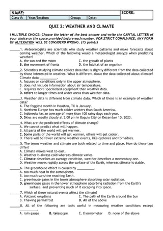
- 1. NAME: SCORE: Class #: Year/Section: Group: Date: QUIZ 2: WEATHER AND CLIMATE I MULTIPLE CHOICE: Choose the letter of the best answer and write the CAPITAL LETTER of your choice on the space provided before each number. FOR STRICT COMPLIANCE, ANY FORM OF ALTERATION WILL BE CONSIDERD WRONG. (15 points) ______1. Meteorologists are scientists who study weather patterns and make forecasts about coming weather. Which of the following would a meteorologist analyze when predicting weather? A. the sun and the moon C. the growth of plants B. the movement of fronts D. the habitat of an organism ______2. Scientists studying climate collect data that is slightly different from the data collected by those interested in weather. What is different about the data collected about climate? Climate data __________. A. focuses on conditions only in the upper atmosphere. B. does not include information about air temperature. C. requires more specialized equipment than weather data. D. refers to longer times and wider areas than weather data. ______3. Weather data is different from climate data. Which of these is an example of weather data? A. The foggiest month in Houston, TX is January. B. Northern Europe has much colder winters than South America. C. Indonesia has an average of more than 100 rainy days each year. D. Skies are mostly cloudy at 5:00 pm in Baguio City on December 10, 2023. ______4. What are the predicted effects of climate change? A. We cannot predict what will happen. B. All parts of the world will get warmer. C. Some parts of the world will get warmer, others will get cooler. D. There will be fewer extreme weather events, like cyclones and tornadoes. ______5. The terms weather and climate are both related to time and place. How do these two differ? A. Climate moves west to east. B. Weather is always cold whereas climate varies. C. Climate describes an average condition, weather describes a momentary one. D. Weather moves rapidly across the surface of the Earth, whereas climate is stable. ______6. The greenhouse effect is caused by __________. A. too much heat in the atmosphere. B. too much sunshine reaching Earth. C. greenhouse gases in the lower atmosphere absorbing solar radiation. D. greenhouse gases in the lower atmosphere absorbing radiation from the Earth's surface, and preventing much of it escaping into space. ______7. Which of these natural events affect the climate? A. Volcanic eruptions C. The path of the Earth around the Sun B. Thawing permafrost D. All of the above ______8. All of the following are tools useful in measuring weather conditions except __________. A. rain gauge B. telescope C. thermometer D. none of the above
- 2. ______9. Tricia's grandma resides in Canada, while she herself is in the Philippines. From April to May, however, when it is summer in the Philippines, Tricia takes a vacation in Winnipeg, Canada. When Tricia left Manila, the temperature was 34 OC, but when she got to Winnipeg, it was only 4 OC. Winnipeg experiences chilly and dry weather, whereas Manila experiences hot and humid weather. How would you explain the difference? I Canada is found in North America while Philippines is in Asia. II Manila’s latitude is 14O 35’ N while Winnipeg’s is 49O 53’ N, which means manila is much closer to the equator. III Manila is located on the eastern shore of Manila while Winnipeg is found on the eastern edge of the Canadian prairies. IV The Philippines is located in both the northern and eastern hemisphere While Canada is positioned in both the northern and western hemisphere. A. I and II only B. II and III only C. II and IV only D. I and IV only ______10. Meteorologists are scientists who study weather patterns and make forecasts about coming weather. Which of the following would a meteorologist analyze when predicting weather? A. the growth of plants C. the movement of fronts B. the Sun and the moon D. the habitat of an organism ______11. Which weather instrument measures atmospheric pressure? A. Barometer B. Anemometer C. Hygrometer D. Thermometer ______12. What is the term for the process by which water vapor changes into liquid water? A. Precipitation B. Condensation C. Evaporation D. Sublimation ______13. What is the phenomenon where warm air traps pollutants close to the ground, often leading to poor air quality? A. Smog B. Acid rain C. Hailstorm D. Tornado ______14. The process by which water falls from the atmosphere to the Earth's surface in the form of rain, snow, sleet, or hail? A. Precipitation B. Evaporation C. Condensation D. Transpiration ______15. The condition where air near the ground is cooled to its dew point, causing water vapor to condense into droplets? A. Fog B. Dew C. Frost D. Humidity II TRUE OR FALSE: Write the word TRUE if the statement is correct and write the word FALSE if the statement is incorrect. Write your answer in the space before each number. ANY FORM OF ERASURES WILL BE CONSIDERED WRONG. (5 points) ____________1. You can define climate as day to day changes in the condition of the atmosphere. F ____________2. People generally keep an eye on the climate to see if rain is expected on the coming weekend. F ____________3. Weather moves rapidly across the surface of the Earth, whereas climate is absolutely stable. F ____________4. Water vapor is the most abundant greenhouse gas in the atmosphere. T ____________5. Agricultural activities contribute the most to carbon emissions globally. F