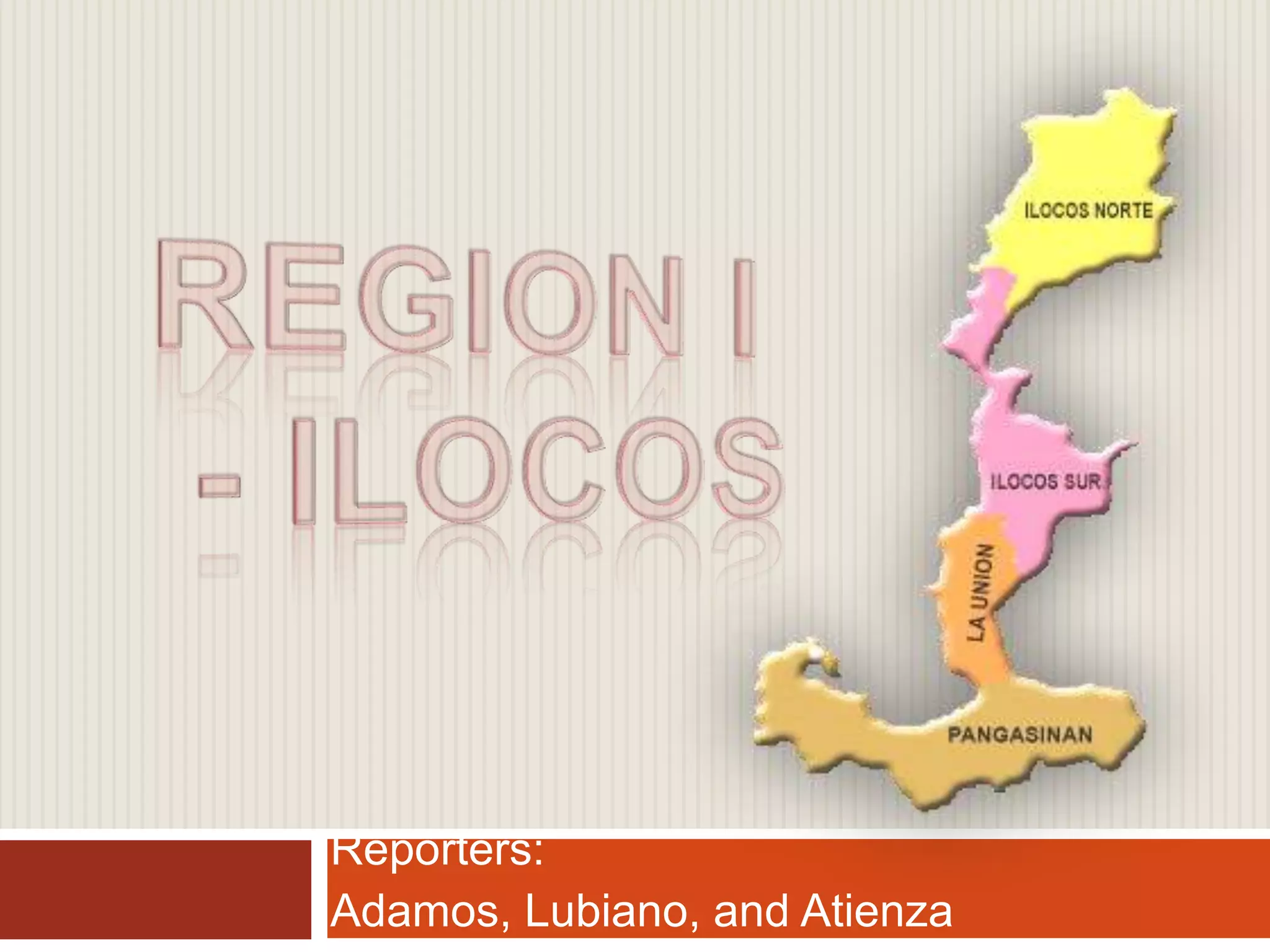
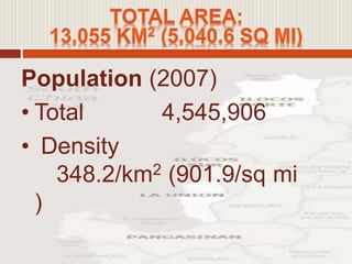
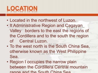
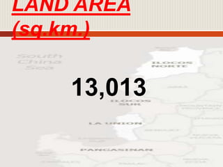
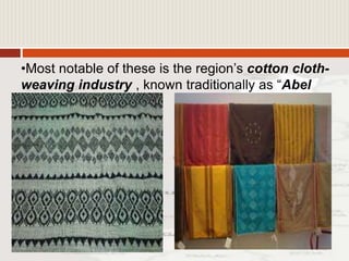
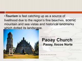
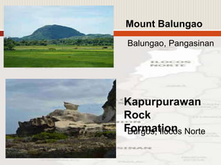
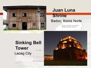
Reporters:
Adamos, Lubiano, and Atienza
 Region I referred to as the Ilocos Region
mainly because it is home to a majority of
Ilokanos and the seat of the Ilokano culture,
heritage and language.
 There are two distinct versions as to were
the word “Ilocos” originated. In Isabelo de
los Reyes ‘Historia de Ilocos’ (1885), he
said that it evolved from the word “ilog”
(river).
 Ilocos means “people in the river”, very
much like the Tagalog’s “taga-ilog” which
referred to the early settler’s living along
• Among the highest mountains in the region
are: Mount Sicapoo (2,360m), Mount
Malaya (2,352m), and Mount burnay (2,
115m).
• Total land area of Region I: 13,013 square
kilometers.
• Several offshore Islands belong to the
region, the largest of which are Anda and
Santiago, including renowned cluster of
Islands and islets known as Hundred
Islands.
 Several modern presidents of the Republic of
the Philippines hailed from the Region: Elpidio
Quirino, Ferdinand Marcos, and Fidel V.
Ramos.
 Before the formation of the Cordillera
Administrative Region, Region 1 also included
the provinces of Abra, Mountain Province, and
Benguet. Before Region 1 was modified by
Ferdinand Marcos, Pangasinan was not part of
the region
• The dialect or language that is use in this
region are Ilocano and Pangasinense.
• Tagalog and English are the medium of
instruction in schools.
• Ilocano is widely used by the majority
people while Pangasinense is spoken in
the central towns of Pangasinan.
• Ilocano
• Pangasinan
• Bolinao
• Tagalog
• English
Population (2007)
• Total 4,545,906
• Density
348.2/km2 (901.9/sq mi
)
• Located in the northwest of Luzon.
• It Administrative Region and Cagayan
Valley borders to the east the regions of
the Cordillera and to the south the region
of Central Luzon.
• To the west north is the South China Sea,
otherwise known as the West Philippine
Sea.
• Region I occupies the narrow plain
between the Cordillera Central mountain
• Occupies the northern portion of the Central
Luzon plain, to the north-east of
the Zambales Mountains.
• Lingayen Gulf is the most notable body of
water in the region and it contains a number
of islands, including the Hundred Islands
National Park.
• To the north of the region is Luzon Strait.
• The Agno river runs through Pangasinan and
empties into the Lingayen Gulf. The river
flow into a broad delta in the vicinity
- Aboriginal tribes (22,000 years ago)
- Malays (Christian era – 13th century)
- Engaged trade with Japanese, Chinese
and Arabs (around 13th century)
Emperor Yung Lo, of
Ming
Dynasty (A.D. 1402-
1424)
- Puerto de Japon
- Martin de Golti (1571)
- Juan Salcedo (1572)
- Villa Fernandina (3rd of the earliest
Spanish settlements to be named cities
after Cebu and Manila)
- Provincia de Ilocos
- Miguel Lopez de Legaspi
- Pangasinan was created a province (1580)
- Founded the town of Bacnotan (1590)
Dagupan (1720)
- Magsingal (1676)
- Santa (1713)
- Lapog(now San Juan) and Cabugao
(1722)
- Sto. Domingo (1742)
- Sta. Maria (1760)
- San Ildefonso (1769)
- Sta. Catalina and San Vicente (1795)
- and Caoayan (1825)
- Dingras Revolt (1587)
- Mallong Rebellion (1660)
- Pedro Almazon Revolt (1661)
- Diego Silang Rebellion (1762-63)
- Juan de la Cruz Palaris Revolt (1762)
- Laoag Uprising (1782)
- Basi or Ambaristo Revolt (1807)
- and many others
ILOCOS
Ilocos Norte Ilocos Sur
- Abra
- Northern
part
of La Union
- Lepanto in
the old Mt.
Province
- ABRA was detached from Ilocos
Sur
with LEPANTO as its
subprovince.
- Northern coastal towns from Agoo to
Bacnotan were severed from
Pangasinan and merged with the
southern part of Ilocos Sur TO FORM
the present province of LA UNION.
- Pangasinan’s territory was further reduced
when three of its southern towns were
carved out to form part of the new province
of Tarlac
- A group of rebels led by Frederico Isabela
Abaya (Kapitan Belong) seized the town of
Candon, Ilocos Norte and revolted against
Spanish rule.
= “IKKIS TI CANDON” (Cry of
Candon)
Gregorio del Pilar Tirad Pass
- American civil government was
established in the region
- Aguinaldo transferred the seat Philippine
First Republic to various provinces in
Central Luzon and finally to Bayambang,
Pangasinan where he disbands his army
and organized guerilla units to escape
pursuing Americans.
American Liberation Forces
also landed on Lingayen Gulf.
- The Ilocos provinces were organized as
such by the virtue of Act 2711
- Ilocos region thrown to historical limelight
when the Japanese landed at Lingayen
Gulf on December 21, 1941.
Ilocos Region was officially established
under PD No. 742 or the Recognition
Plan with the province of Abra, Benguet
and Mt. Province including its territories.
However, with the creation of autonomous
region of Cordilleras through RA 6766 and
a plebiscite on January 30, 1990, the said
provinces were severed from Region I,
leaving it with the present four provinces
which comprise its territory.
LAND AREA
(sq.km.)
13,013
DEMOGRAPHY
Population (2008): 4,974,000
Population density/sq. km.: 1.10%
Male Population: 2,498, 200
Female Population: 2,475,800
Female-Male Ratio: 1: 1.009
No. of Families(2006): 947
LOCAL
GOVERNMENT
No. of Cities: 9
No. of Municipalities: 116
No. of Brgys.: 3,265
No. of Provinces: 4
EDUCATION (SY 2006-
2007)
Literacy (In percent):
Male: 88.1
Female: 89.2
No. of Schools:
Elementary: 2,453
Secondary: 450
No. of Teachers:
Elementary: 21,078
Secondary: 8,573
Enrolment:
Elementary: 607,670
Secondary: 294, 960
Teacher-student ratio:
Elementary: 1:29
Secondary: 1:34
Farming
Fishing
•Pangasinan alone produces more than a
half of Region 1’s rice output .
•Ilocos Region is basically a tobacco
country. Ilocos Sur has the largest area in
region and perhaps in the country for
tobacco production .•The region also yield a sizeable amount of
corn, garlic, sugarcane, cotton, cassava,
onion, vegetables and fruits, such as grapes
which are extensively grown in Bauang, La
Union.
•Pangasinan has the largest volume of fish catch
in the region and has extensive
fishponds near its coasts for bangus, prawn and
oyster cultivation. It is also known
for its salt-making, bagoong (fish salt) and
shrimp paste industry.
•Cottage Industries abound in the region and
become an income –generating
enterprise for families.
•The vast Lingayen Gulf is a rich fishing grounds
especially for La Union and Pangasinan.
•Most notable of these is the region’s cotton cloth-
weaving industry , known traditionally as “Abel
Iloko”.
•Basi-making industry which is derived from
fermented sugar cane juice.
•Tourism is fast catching up as a source of
livelihood due to the region’s fine beaches, scenic
mountain and sea vistas and historical landmarks
which dotted its landscape.
Paoay Church
Paoay, Ilocos Norte
Mount Balungao
Balungao, Pangasinan
Kapurpurawan
Rock
FormationBurgos, Ilocos Norte
Juan Luna
Shrine
Badoc, Ilocos Norte
Sinking Bell
Tower
Laoag City
Region i report

Region i report

  • 1.
  • 3.
     Region Ireferred to as the Ilocos Region mainly because it is home to a majority of Ilokanos and the seat of the Ilokano culture, heritage and language.  There are two distinct versions as to were the word “Ilocos” originated. In Isabelo de los Reyes ‘Historia de Ilocos’ (1885), he said that it evolved from the word “ilog” (river).  Ilocos means “people in the river”, very much like the Tagalog’s “taga-ilog” which referred to the early settler’s living along
  • 4.
    • Among thehighest mountains in the region are: Mount Sicapoo (2,360m), Mount Malaya (2,352m), and Mount burnay (2, 115m). • Total land area of Region I: 13,013 square kilometers. • Several offshore Islands belong to the region, the largest of which are Anda and Santiago, including renowned cluster of Islands and islets known as Hundred Islands.
  • 5.
     Several modernpresidents of the Republic of the Philippines hailed from the Region: Elpidio Quirino, Ferdinand Marcos, and Fidel V. Ramos.  Before the formation of the Cordillera Administrative Region, Region 1 also included the provinces of Abra, Mountain Province, and Benguet. Before Region 1 was modified by Ferdinand Marcos, Pangasinan was not part of the region
  • 6.
    • The dialector language that is use in this region are Ilocano and Pangasinense. • Tagalog and English are the medium of instruction in schools. • Ilocano is widely used by the majority people while Pangasinense is spoken in the central towns of Pangasinan.
  • 7.
    • Ilocano • Pangasinan •Bolinao • Tagalog • English
  • 8.
    Population (2007) • Total4,545,906 • Density 348.2/km2 (901.9/sq mi )
  • 9.
    • Located inthe northwest of Luzon. • It Administrative Region and Cagayan Valley borders to the east the regions of the Cordillera and to the south the region of Central Luzon. • To the west north is the South China Sea, otherwise known as the West Philippine Sea. • Region I occupies the narrow plain between the Cordillera Central mountain
  • 10.
    • Occupies thenorthern portion of the Central Luzon plain, to the north-east of the Zambales Mountains. • Lingayen Gulf is the most notable body of water in the region and it contains a number of islands, including the Hundred Islands National Park. • To the north of the region is Luzon Strait. • The Agno river runs through Pangasinan and empties into the Lingayen Gulf. The river flow into a broad delta in the vicinity
  • 12.
    - Aboriginal tribes(22,000 years ago) - Malays (Christian era – 13th century) - Engaged trade with Japanese, Chinese and Arabs (around 13th century) Emperor Yung Lo, of Ming Dynasty (A.D. 1402- 1424) - Puerto de Japon
  • 13.
    - Martin deGolti (1571) - Juan Salcedo (1572) - Villa Fernandina (3rd of the earliest Spanish settlements to be named cities after Cebu and Manila) - Provincia de Ilocos - Miguel Lopez de Legaspi
  • 14.
    - Pangasinan wascreated a province (1580) - Founded the town of Bacnotan (1590) Dagupan (1720)
  • 15.
    - Magsingal (1676) -Santa (1713) - Lapog(now San Juan) and Cabugao (1722) - Sto. Domingo (1742) - Sta. Maria (1760) - San Ildefonso (1769) - Sta. Catalina and San Vicente (1795) - and Caoayan (1825)
  • 16.
    - Dingras Revolt(1587) - Mallong Rebellion (1660) - Pedro Almazon Revolt (1661) - Diego Silang Rebellion (1762-63) - Juan de la Cruz Palaris Revolt (1762) - Laoag Uprising (1782) - Basi or Ambaristo Revolt (1807) - and many others
  • 17.
    ILOCOS Ilocos Norte IlocosSur - Abra - Northern part of La Union - Lepanto in the old Mt. Province
  • 18.
    - ABRA wasdetached from Ilocos Sur with LEPANTO as its subprovince.
  • 19.
    - Northern coastaltowns from Agoo to Bacnotan were severed from Pangasinan and merged with the southern part of Ilocos Sur TO FORM the present province of LA UNION.
  • 20.
    - Pangasinan’s territorywas further reduced when three of its southern towns were carved out to form part of the new province of Tarlac
  • 21.
    - A groupof rebels led by Frederico Isabela Abaya (Kapitan Belong) seized the town of Candon, Ilocos Norte and revolted against Spanish rule. = “IKKIS TI CANDON” (Cry of Candon)
  • 22.
    Gregorio del PilarTirad Pass - American civil government was established in the region
  • 23.
    - Aguinaldo transferredthe seat Philippine First Republic to various provinces in Central Luzon and finally to Bayambang, Pangasinan where he disbands his army and organized guerilla units to escape pursuing Americans.
  • 24.
    American Liberation Forces alsolanded on Lingayen Gulf.
  • 25.
    - The Ilocosprovinces were organized as such by the virtue of Act 2711 - Ilocos region thrown to historical limelight when the Japanese landed at Lingayen Gulf on December 21, 1941.
  • 26.
    Ilocos Region wasofficially established under PD No. 742 or the Recognition Plan with the province of Abra, Benguet and Mt. Province including its territories. However, with the creation of autonomous region of Cordilleras through RA 6766 and a plebiscite on January 30, 1990, the said provinces were severed from Region I, leaving it with the present four provinces which comprise its territory.
  • 27.
  • 28.
    DEMOGRAPHY Population (2008): 4,974,000 Populationdensity/sq. km.: 1.10% Male Population: 2,498, 200 Female Population: 2,475,800 Female-Male Ratio: 1: 1.009 No. of Families(2006): 947
  • 29.
    LOCAL GOVERNMENT No. of Cities:9 No. of Municipalities: 116 No. of Brgys.: 3,265 No. of Provinces: 4
  • 30.
    EDUCATION (SY 2006- 2007) Literacy(In percent): Male: 88.1 Female: 89.2 No. of Schools: Elementary: 2,453 Secondary: 450
  • 31.
    No. of Teachers: Elementary:21,078 Secondary: 8,573 Enrolment: Elementary: 607,670 Secondary: 294, 960 Teacher-student ratio: Elementary: 1:29 Secondary: 1:34
  • 33.
  • 34.
    •Pangasinan alone producesmore than a half of Region 1’s rice output . •Ilocos Region is basically a tobacco country. Ilocos Sur has the largest area in region and perhaps in the country for tobacco production .•The region also yield a sizeable amount of corn, garlic, sugarcane, cotton, cassava, onion, vegetables and fruits, such as grapes which are extensively grown in Bauang, La Union.
  • 35.
    •Pangasinan has thelargest volume of fish catch in the region and has extensive fishponds near its coasts for bangus, prawn and oyster cultivation. It is also known for its salt-making, bagoong (fish salt) and shrimp paste industry. •Cottage Industries abound in the region and become an income –generating enterprise for families. •The vast Lingayen Gulf is a rich fishing grounds especially for La Union and Pangasinan.
  • 36.
    •Most notable ofthese is the region’s cotton cloth- weaving industry , known traditionally as “Abel Iloko”.
  • 37.
    •Basi-making industry whichis derived from fermented sugar cane juice.
  • 38.
    •Tourism is fastcatching up as a source of livelihood due to the region’s fine beaches, scenic mountain and sea vistas and historical landmarks which dotted its landscape. Paoay Church Paoay, Ilocos Norte
  • 39.
  • 40.
    Juan Luna Shrine Badoc, IlocosNorte Sinking Bell Tower Laoag City