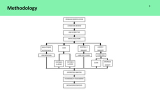
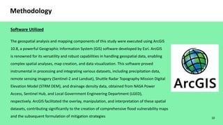
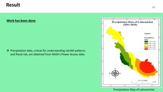
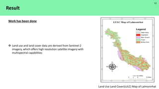
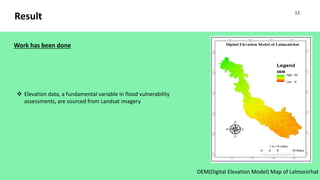
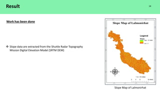
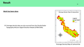
1. Presented By
SAJIB CHANDRA SUTRADHAR
Exam Roll: 1415
Reg. No: 783
ANAS BIN ZOBAIR
Exam Roll: 1413
Reg. No: 762
PROJECT AND THESIS
COURSE CODE: CE 700
A Presentation on
Assessing Flood Vulnerability and Mitigation
Strategies in Lalmonirhat, Bangladesh :
A Geospatial Analysis.
Supervised By
Tahia Rabbee
Lecturer
Department of Civil Engineering
Mymensingh Engineering College
A REPORT SUBMITTED TO DEPARTMENT OF CIVIL ENGINEERING,
MYMENSINGH ENGINEERING COLLEGE
1
3. Introduction
Floods have long cast their shadow over the landscape of
Bangladesh, a nation endowed with fertile lands and abundant
water resources, yet equally burdened by its vulnerability to the
recurring deluge. As a low-lying deltaic country situated at the
confluence of the Ganges, Brahmaputra, and Meghna rivers,
Bangladesh contends with the dual blessings and curses of its
geographical setting. The annual monsoons and the dynamics of
these mighty rivers have bestowed upon Bangladesh both
prosperity through agriculture and the unrelenting specter of
catastrophic floods. Among the regions bearing the brunt of this
climatic and hydrological paradox, Lalmonirhat stands as a
microcosm of the nation's intricate relationship with water.
3
4. Objectives
To develop Vulnerability Factor Maps: Using remote sensing and GIS techniques to build vulnerability factor
(Precipitation, Slope, Elevation, Land Use Land Cover, Drainage Density, Distance to Road, and Distance to River) maps for
Lalmonirhat.
To develop Precise Flood Hazard Maps: Using remote sensing and GIS techniques to build precise flood hazard maps for
Lalmonirhat.
To Evaluate Existing Mitigation Strategies: Analyze the effectiveness of current flood mitigation measures, both structural
(such as embankments) and non-structural (such as community-based initiatives).
To Propose Context-Specific Mitigation Strategies: Develop sustainable flood mitigation strategies customized to the
unique challenges and vulnerabilities of the Lalmonirhat region.
To Provide Policy Recommendations: Assisting local and national policymakers in making well-informed decisions and
increasing Lalmonirhat's flood resilience by providing them with evidence-based insights and recommendations.
4
5. Literature Review
Since According to a study about Flood Vulnerabiity done by Himel, T.I.,et al (2021),
a geospatial techniques to assess the spatial extent of flood vulnerability based on the
socioeconomic and physical aspects. They also described what are indicators
affecting this vulnerability. It is enumerated that floods covered 29% of the natural
disasters in Bangladesh from 1971 to 2018 which resulted in a huge economic loss,
property damages, causalities, and homelessness, 1974 about 38 million people were
affected where 28,700 died and economic losses were $579.2 million, in 1998 the
economic losses were at recorded amount $4.3 billion, in 2017 6.9 million people
were affected and 134 people died (Philip et al., 2019; Mondal, Murayama and
Nishikizawa, 2020). This information indicates that in the previous the loss of life
was more but now it is less although the economic losses have increased.
5
6. Literature Review
Lalmonirhat, Bangladesh
Lalmonirhat, located in the northern part of
Bangladesh, occupies a strategic position within the
sprawling Ganges-Brahmaputra Delta. The district's
geography is characterized by a predominantly flat and
low-lying terrain, with an average elevation of
approximately 20 meters above sea level. This unique
topography renders Lalmonirhat highly susceptible to
flooding, a threat exacerbated by its proximity to the
Himalayan foothills and the confluence of major rivers.
6
Study Area
7. Flood vulnerability, a multidimensional concept, encompasses a range of factors that collectively
determine how susceptible an area or community is to the adverse impacts of flooding.
These factors include the physical characteristics of the region, such as its elevation, proximity to
water bodies, and geological features. Low-lying areas and regions near rivers or coasts are often
more physically vulnerable due to their increased exposure to floodwaters.
Socio-economic vulnerability considers the human dimension, incorporating elements like income
levels, access to education and healthcare, employment opportunities, and overall quality of life.
Communities with limited resources and underdeveloped infrastructure may find it challenging to
prepare for, respond to, and recover from floods, heightening their socio-economic vulnerability.
7
Literature Review
Vulnerability
8. Flood mitigation strategies are a comprehensive set of measures designed to minimize the impact of floods on
communities, infrastructure, and the environment.
Structural measures typically involve physical interventions that alter the landscape or watercourse to control or
redirect floodwaters. These include levees, embankments, floodwalls, dams, reservoirs, and channel modifications.
Non-structural flood mitigation measures, on the other hand, focus on policies, planning, and community-based
strategies to reduce vulnerability. Early warning systems, a critical non-structural measure, provide advance notice
of impending floods using weather forecasting, river gauges, and communication networks, enabling timely
evacuations and protective actions.
8
Literature Review
Flood Mitigation Strategy
10. 10
Methodology
Software Utilized
The geospatial analysis and mapping components of this study were executed using ArcGIS
10.8, a powerful Geographic Information System (GIS) software developed by Esri. ArcGIS
is renowned for its versatility and robust capabilities in handling geospatial data, enabling
complex spatial analyses, map creation, and data visualization. This software proved
instrumental in processing and integrating various datasets, including precipitation data,
remote sensing imagery (Sentinel-2 and Landsat), Shuttle Radar Topography Mission Digital
Elevation Model (STRM DEM), and drainage density data, obtained from NASA Power
Access, Sentinel Hub, and Local Government Engineering Department (LGED),
respectively. ArcGIS facilitated the overlay, manipulation, and interpretation of these spatial
datasets, contributing significantly to the creation of comprehensive flood vulnerability maps
and the subsequent formulation of mitigation strategies
11. Result
Work has been done
Precipitation data, critical for understanding rainfall patterns
and flood risk, are obtained from NASA's Power Access data.
Precipitation Map of Lalmonirhat
11
12. Result
Land use and land cover data are derived from Sentinel-2
imagery, which offers high resolution satellite imagery with
multispectral capabilities
Work has been done
Land Use Land Cover(LULC) Map of Lalmonirhat
12
13. Result
DEM(Digital Elevation Model) Map of Lalmonirhat
Elevation data, a fundamental variable in flood vulnerability
assessments, are sourced from Landsat imagery
Work has been done
13
14. Result
Work has been done
Slope data are extracted from the Shuttle Radar Topography
Mission Digital Elevation Model (SRTM DEM)
Slope Map of Lalmonirhat
14
15. Result
Work has been done
Drainage Density Map of Lalmonirhat
Drainage density data are also sourced from the Shuttle Radar
Topography Mission Digital Elevation Model (STRM DEM).
15
16. Result
Work to be done:
Distance to Road Map creation.
Distance to River Map creation.
Flood Vulnerability Map creation using the Weighted Overlay Process.
Analyze the effectiveness of current flood mitigation measures.
Develop sustainable flood mitigation strategies customized to the unique challenges and vulnerabilities of the
Lalmonirhat region.
16
17. 17
Conclusion
In the pursuit of assessing flood vulnerability and formulating mitigation strategies in Lalmonirhat, Bangladesh, the progress
achieved thus far stands as a testament to our commitment to addressing one of the region's most pressing challenges. The
creation of maps for critical factors, including precipitation, land use land cover (LULC), elevation, slope, and drainage
density, has provided us with valuable spatial insights that are pivotal for understanding the intricate interplay of variables
contributing to flood vulnerability. These maps serve as foundational tools, illuminating areas susceptible to heavy rainfall,
urban expansion, low-lying terrain, steep slopes, and efficient drainage networks. However, it is important to recognize that
these maps represent a significant step within a broader, interconnected framework. To realize our objectives fully, we must
now integrate these spatial datasets with the crucial elements of distance to roads and rivers, forging a comprehensive flood
vulnerability assessment. This holistic approach will empower us to develop precise, locationspecific mitigation and
preparedness strategies that can bolster the region's resilience in the face of recurrent floods and the ever-evolving
challenges posed by climate change. As we move forward, this work serves as both a foundation and a clarion call for
continued dedication to safeguarding the lives, livelihoods, and future of Lalmonirhat's communities.
18. Reference
• Ahmadlou M, Al-Fugara AK, Al-Shabeeb AR, Arora A, Al-Adamat R, Pham QB, Al-Ansari N, Linh N, Sajedi H. 2021. Flood
susceptibility mapping and assessment using a novel deep learning model combining multilayer perceptron and
autoencoder neural networks. J Flood Risk Manage. 14(1):e12683.
• De Moel H, Jongman B, Kreibich H, Merz B, Penning-Rowsell E, Ward PJ. 2015. Flood risk assessments at different spatial
scales. Mitig Adapt Strateg Glob Chang. 20(6):865–890.
• Dewan TH. 2015. Societal impacts and vulnerability to floods in Bangladesh and Nepal. Weather Clim Extremes. 7:36–42.
• Mojaddadi H, Pradhan B, Nampak H, Ahmad N, Ghazali A. 2017. Ensemble machine-learning-based geo-spatial approach
for flood risk assessment using multi-sensor remote-sensing data and GIS. Geomatics Nat Hazards Risk. 8(2):1080–1102.
• Nguyen HD, Nguyen Q-H, Du Q, Nguyen T, Nguyen TG, Bui Q-T. 2021. A novel combination of deep neural network and
manta ray foraging optimization for flood susceptibility mapping in Quang Ngai Province, Vietnam. Geocarto Int. 1– 25.
• Pham BT, Luu C, Van Dao D, Van Phong T, Nguyen HD, Van Le H, Von Meding J, Prakash I. 2021a. Flood risk assessment
using deep learning integrated with multi-criteria decision analysis. Knowledge Based Syst. 219:106899.
• Pham BT, Luu C, Van Phong T, Nguyen HD, Van Le H, Tran TQ, Ta HT, Prakash I. 2021b. Flood risk assessment using hybrid
artificial intelligence models integrated with multi-criteria decision analysis in Quang Nam Province, Vietnam. J Hydrol.
592:125815.
• Talukdar S, Ghose B, Salam R, Mahato S, Pham QB, Linh N, Costache R, Avand M. 2020. Flood susceptibility modeling in
teesta river basin, bangladesh using novel ensembles of bagging algorithms. Stochastic Environ Res Risk Assess.
34(12):2277–2300
18