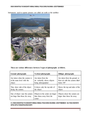
The document provides information about tutoring services offered by Teacher Bau from Kisauni. It offers tuition for students from Standard 5 to Form 4 in subjects like Science and Math. The tuition is offered at their office located near Miti. The center has experienced teachers including the head teacher of Kombeni Primary School. They also provide study materials for subjects like Physics, Chemistry, Mathematics, History, Biology and Geography. Contact details and information on how to order additional study materials is provided at the end.
Explore beautiful and ugly buildings. Mathematics helps us create beautiful d...
Photograph reading and interpretation
1. KWA MAENDELEO YA MWANAOMLETE KATIKA KITUOCHETU
SHITI HILI LIMEANDALIWA NA MUSSA BAUJITI NO+255742868019
0
PHOTOGRAPH READING
AND INTERPRETATION
PREPARED BY TEACHER
BAU FROM KISAUNI
BOT
TUNAPOKEA WANAFUNZIKUANZIA DARASALA TANO
MPAKA KIDATU CHA NNEKWA MASOMO YA SAYANSI
NA SANA (TUITION) FIKA KATIKA OFISIZETU
PANAPOUZWA MITI.KITUOCHETU KINA WALIMU
WAZOEFU WALIOBOBEA KIPOCHINIYA DHAMANA YA
MWALIMU MKUU WA SKULI YA KOMBENI.PIA
TUNATOA MASHITI MBALI MBALI KAMA VILE
PHYSICS,CHEMISTRY,MATHEMATICS,
HISTORY,BIOLOGYGEOGRAPHY NK
KWA MAWASILIANO ZAIDI PIGA SIMU NAMBA
+255773844810 AU +255742868019
2. KWA MAHITAJI YAMASHITI MBALI MBALI PIGASIMUNUMBA +255773844810
1 | KWA MAHITAJI YA MASHITI MBALI MBALI PIGASIMUNUMBA +255773844810 AU FIKA KWENYE
OFISI ZETU PANAPOUZWAMITI
1
PHOTOGRAPH READING AND INTERPRETATION
Photograph
Is an image of an object which is recorded by a camera and then printed on paper
Or
Is a picture taken by means of chemical lights prepared on a special paper
Types of photographs
i) Horizontal photographs/Group photographs
ii) Oblique photographs
iii) Vertical photographs
1. HORIZONTAL PHOTOGRAPHS/GROUP PHOTOGRAPHS
These are photographs that are taken from the ground when the camera is at the same level as the
object being photographed.
Objects are large and clearly shown in these photographs when they are close than those far
from the camera
The fore ground and the horizon is seen but the back /dead ground is not seen
3. KWA MAHITAJI YAMASHITI MBALI MBALI PIGASIMUNUMBA +255773844810
2 | KWA MAHITAJI YA MASHITI MBALI MBALI PIGASIMUNUMBA +255773844810 AU FIKA KWENYE
OFISI ZETU PANAPOUZWAMITI
2
There is no fixed scale
2. OBLIQUE PHOTOGRAPHS
Are the photographs taken hen a camera is slanting at an angle less than 90°. They are
taken when the photographer is standing on an elevated ground and hold the camera on
an angle towards the lower ground .They normally cover the horizon.
4. KWA MAHITAJI YAMASHITI MBALI MBALI PIGASIMUNUMBA +255773844810
3 | KWA MAHITAJI YA MASHITI MBALI MBALI PIGASIMUNUMBA +255773844810 AU FIKA KWENYE
OFISI ZETU PANAPOUZWAMITI
3
3) VERTICAL PHOTOGRAPHS
These are photographs taken from the air with the camera directly above the object pointing
vertically to the ground.
Only the top view is seen
5. KWA MAHITAJI YAMASHITI MBALI MBALI PIGASIMUNUMBA +255773844810
4 | KWA MAHITAJI YA MASHITI MBALI MBALI PIGASIMUNUMBA +255773844810 AU FIKA KWENYE
OFISI ZETU PANAPOUZWAMITI
4
Instruments used to capture pictures are called air crafts or the satellites
These are various differences between 3 types of photographs as follows.
Ground photographs Vertical photographs Oblique photographs
Are taken when the camera is
at the same level with the
object
Are taken from the
air vertically above objects
being photographed
Are taken from the ground or
from air with the camera tilted
below 900
They show side of the object
facing the camera.
It shows only the top side of
the object
Shows the top and sides of the
object
Size of object near the camera
are large than those far away
Objects in the center are larger
than those away from the
center
Objects closer the camera are
larger than those far away
6. KWA MAHITAJI YAMASHITI MBALI MBALI PIGASIMUNUMBA +255773844810
5 | KWA MAHITAJI YA MASHITI MBALI MBALI PIGASIMUNUMBA +255773844810 AU FIKA KWENYE
OFISI ZETU PANAPOUZWAMITI
5
Show relatively small area Show relatively large area Show relatively largest area
possible
PARTS OF PHOTOGRAPH
In order to study and refer the position in the photograph
properly ,It s necessary to divide photograph into appropriate
parts .The photograph is devided into three parts both
horizontally and vertically .
Horizontally ,It is divided into foreground, middle ground and
back ground .The foreground is the area nearest to the
camera,middle ground is the area between foreground and the back
ground ,where as background is the furthest area from the
camera.
middle ground is the area between foreground and the background,
where as background is the farthest area from the camera.
For case of description of location onto features on the
photograph it is appropriate to use these division.
Left Centre Right
left background central background right background
left middle ground central middle ground Right middle background
left foreground central foreground right foreground
7. KWA MAHITAJI YAMASHITI MBALI MBALI PIGASIMUNUMBA +255773844810
6 | KWA MAHITAJI YA MASHITI MBALI MBALI PIGASIMUNUMBA +255773844810 AU FIKA KWENYE
OFISI ZETU PANAPOUZWAMITI
6
The table gives appropriate description of both horizontal and
vertical interpretation of photograph
READING AND INTERPRETATION OF PHOTOGRAPH
Is the process of reading, measuring, translating and explaining the meaning of objects identified
on that photograph.
It is done so as to obtain reliable information about the natural or cultural features on their
environments. It involves the following;
Determining the title
Estimating time and the season
Estimating direction
Identifying and interpreting physical features
Identifying and interpreting human activities
Estimating the size of phenomena
Suggesting possible location of the scenery in the place
DETERMINING THE TITLE
Can be obtained by carefully studying the photograph, information determines the choice of the
title. Photos show landscapes, activities on land, what is on the surface and the sky. The
information contained in the foreground, middle ground and dead ground can help in
determining a suitable title
ESTIMATING TIME AND SEASON
It is possible to estimate the time of day when the photo was taken if we know where the
photograph was taken
1) If the photo was taken during the morning its evidence is through the shadow
During the morning
8. KWA MAHITAJI YAMASHITI MBALI MBALI PIGASIMUNUMBA +255773844810
7 | KWA MAHITAJI YA MASHITI MBALI MBALI PIGASIMUNUMBA +255773844810 AU FIKA KWENYE
OFISI ZETU PANAPOUZWAMITI
7
The shadow of the object lies in the western side because the sun rises from the east
2) During the evening
The shadow lies in the eastern side because the sun sets on the west
3) During the after noon
The shadow lies around the object because the sun is over head of the object
SEASONS
A bright sky with dry vegetation may indicate a dry period or season.
Thick vegetation young crops or flowering plants in the field and a sky full of rain
clouds indicate a rainy season
Clear sunny conditions with health vegetation and flowering plants or plants with fruits
indicate summer season
Plants with young leaves others bloom and field full of grass indicates spring season
Hazy sky with leafless trees and some snow on the ground indicates winter season
Also when people appear to be wearing heavy clothes with faces almost completely
covered, hand gloves and heavy boots it indicates cold weather, likely winter in
temperate regions
People wear light clothes and some may even have broad-rimmed hats indicates hot
weather
When houses appear to have slanting roofs it indicates the region experiencing a lot of
precipitation which facilitates the easy flow of water from the roof of the house
If people appear to be planting then it is planting season the rains either are about to
come or have just started
If the people appear to be weeding it is growing season for the crops and there is
reduced rainfall
If people appear to be harvesting a crop it is harvesting season and probably dry season
because harvesting normally takes place during dry weather.
ESTIMATING DIRECTION
9. KWA MAHITAJI YAMASHITI MBALI MBALI PIGASIMUNUMBA +255773844810
8 | KWA MAHITAJI YA MASHITI MBALI MBALI PIGASIMUNUMBA +255773844810 AU FIKA KWENYE
OFISI ZETU PANAPOUZWAMITI
8
It is possible to estimate direction on the photo using shadows if time and place are
known
If a photograph shows trees whose shadow is on the right and is taken in the
morning the photographers direction is south
If the shadow is pointing towards you on the photo and the photo was taken in the
afternoon (sun was in the west) then the camera was facing westwards.
IDENTIFICATION AND INTERPRETATION OF PHYSICAL FEATURES
Many varieties of physical features can be identified on
photographs. These includes features of relief, drainage and
vegetation
A) RELIEF
It is necessary to first identify feature of relief on the given
photograph. These features appear the way they do in real nature
.When describing relief on photograph one should start giving a
general idea about the area shown in the photograph.
On the ground photograph, it is possible to identify flat land
scapes ,hilly areas and mountainous relief. Other details can be
fitted within this general outlook.
B) DRAINAGE
Drainage features such as rivers, lakes and other alike water
bodies can be easily identified on all types of photographs. On
ground/Horizontal and some obliques rivers may not be easy to
study because of obstruction and intervening obstacles ,
Different aspect of rivers can be studied including the shape of
either valleys and develop of different features. For example
;presence of rapid waterfalls is an indication of river flowing
over steep land , River meanders indicates the mature stage of
the it or even old stage .Drainage pattern. May indicate the
highland areas and normally can be taken by aerial photograph
while presence of big meanders, lake or ocean indicate lowland
areas with high rate of deposition as the effect of erosion done
at highland areas.
10. KWA MAHITAJI YAMASHITI MBALI MBALI PIGASIMUNUMBA +255773844810
9 | KWA MAHITAJI YA MASHITI MBALI MBALI PIGASIMUNUMBA +255773844810 AU FIKA KWENYE
OFISI ZETU PANAPOUZWAMITI
9
C) VEGETATION
Photograph shows all types of vegetation present in the
photographed area. It is however difficult to distinguish
certain types of vegetation foristance natural from derived
vegetation. Planted vegetation may be easier to identify because
of their unique character .Trees in clear straight row and the
same height in photograph indicate the planted forest ,where as
random arrangement and height indicate the natural vegetation .
Photograph interpretation with thick forest and greenish
indicate the area with arable rainfall and rich in fertile
,photographs with less vegetation indicate the area with less or
no rainfall which referred as semi- arid and arid areas in this
areas photos may also show cactus plants acacia trees, jacaranda
plants etc
CLIMATE
Climate is not shown in a photograph but can be used to give
conclusion on the type of an areas. The characteristics of the
sky can give a clue about the weather and season when the photo
was taken ,
(a) Presence of thick cumulus or cumulonimbus clouds indicate a
rainy season while a clear sky may imply a dry season
(b)The type of clothing people in the photograph are wearing
gives a clue about the weather and possible climate i.e. light
clothe indicates the hot climate condition and heavy clothes
indicates the cold condition
11. KWA MAHITAJI YAMASHITI MBALI MBALI PIGASIMUNUMBA +255773844810
10 | KWA MAHITAJI YA MASHITI MBALI MBALI PIGASIMU NUMBA+255773844810 AU FIKA KWENYE
OFISI ZETU PANAPOUZWAMITI
10
(c) The type of vegetation shown, provides a clue about the
season or climate of a place
For example ; presence of numerous cacti may indicate the semi
arid or arid climate ,crops such as sisal grown in hot areas
that may receive low rainfall while sugar cane thrives in warm
to hot climate with high rainfall.
IDENTIFICATION AND INTERPRETATION OF HUMAN ACTIVITIES
FARMING/ AGRICULTURE
Crop cultivation and live stock keeping
Vertical aerial photographs may require close scrutiny to be able to identify. It is fairly easy to
distinguish these two types of ground photographs
Type of farming Evidence to look for.
1. Subsistence crop farming
Some houses are permanent and
others are temporary
Land is divided in small portions
2. Subsistence live stock farming.
Mixed cropping
Simple farm tools such as pangas and
hoes
Fields are separated by hedges
Local and exotic animal breeds are
kept
Animal grazing on grassland/semi
arid regions
Large herds of indigenous cows and
12. KWA MAHITAJI YAMASHITI MBALI MBALI PIGASIMUNUMBA +255773844810
11 | KWA MAHITAJI YA MASHITI MBALI MBALI PIGASIMU NUMBA+255773844810 AU FIKA KWENYE
OFISI ZETU PANAPOUZWAMITI
11
goats
3. Commercial live stock farming RANCHING
Large fields divided in paddocks
Presence of cattle heads near farm
houses
Wind mills for water supply
Presence of water tanks, ponds and
reservoirs in dry areas
Cattle dip on the farm.
DRY FARMING
High grade exotic cows with large
udders
Milk processing plant
Indoor grazing unit
4. Commercial crop farming
Presence of cash crops on extensive
area
Modern farming methods (farm
machinery)
Facilities for collecting produce (
shades and stores)
Presence of feeder routes in the farm
13. KWA MAHITAJI YAMASHITI MBALI MBALI PIGASIMUNUMBA +255773844810
12 | KWA MAHITAJI YA MASHITI MBALI MBALI PIGASIMU NUMBA+255773844810 AU FIKA KWENYE
OFISI ZETU PANAPOUZWAMITI
12
5. Plantation farming
A single crop on an extensive area
Processing factories
Presence of storage facilities
Many laborers on the field
SETTLEMENTS
Settlement comprises a group of buildings in area where people live and carry out social and
economic activities
Settlements may be of two main groups:
i) Rural
ii) Urban
RURAL SETTLEMENTS
Can be indicated by;
Simple semi permanent and permanent buildings such as grass roofed houses or iron
roofed houses with mud or brick walls
Farming, grazing or fishing
Unplanned presence of villages
URBAN SETTLEMENTS
Permanent buildings
Regular street patterns
Many large buildings and ware houses for industrial area
High number of people if shown
Many motor vehicles
Port facilities [ docks, cranes, ware houses, containers]
14. KWA MAHITAJI YAMASHITI MBALI MBALI PIGASIMUNUMBA +255773844810
13 | KWA MAHITAJI YA MASHITI MBALI MBALI PIGASIMU NUMBA+255773844810 AU FIKA KWENYE
OFISI ZETU PANAPOUZWAMITI
13
INDUSTRIAL AND MINING ACTIVITIES
Evidences
Factory buildings with tall chimney for issuing smoke
Large ware houses next to the building
Large lorries carrying loads of rocks indicates open cast mining
A vast area with derrick/oil rigs indicate oil fields
Also lumbering activities
people cutting trees
people loading trees /lumber on lorries
logs floating down on rivers
logs pilled near a sawmill
large forest clearings
Many road ways ending on the forest.
TRANSPORT AND COMMUNICATION
The following are some of the dues on transport
motor vehicles and roads
a railway line
Presence of boats and ships and large water vessels
Animal carrying loads on their backs
Facilities for communication are due to the presence of
Telephone lines
Telephone booths
Satellite dishes
Televisions
15. KWA MAHITAJI YAMASHITI MBALI MBALI PIGASIMUNUMBA +255773844810
14 | KWA MAHITAJI YA MASHITI MBALI MBALI PIGASIMU NUMBA+255773844810 AU FIKA KWENYE
OFISI ZETU PANAPOUZWAMITI
14
BOT
TUNAPOKEA WANAFUNZIKUANZIA DARASALA TANOMPAKA KIDATUCHA NNEKWA MASOMO YA
SAYANSINA SANA (TUITION) FIKA KATIKA OFISIZETUPANAPOUZWA MITI.KITUOCHETU KINA WALIMU
WAZOEFU WALIOBOBEA KIPOCHINIYA DHAMANA YA MWALIMU MKUU WA SKULI YA KOMBENI.PIA
TUNATOA MASHITI MBALI MBALI KAMA VILE PHYSICS,CHEMISTRY,MATHEMATICS,HISTORY,BIOLOGY
GEOGRAPHY NK
KWA MAWASILIANO ZAIDI PIGA SIMU NAMBA
+255773844810 AU +255742868019