Download to read offline
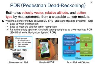

![AR by PDR + Image registration (1999-2003)
Panorama-based Annotation:
IWAR1999, ISWC2001,
ISMAR2003
G
Environmental map
A
B C D
E
A
B
C
F
Input frames
Position at which
a panorama is taken
Position
Direction
235 [deg]
5 [deg]
From the user’s
camera
Located Orientated
5](https://image.slidesharecdn.com/sc24-wg9-pdr-kurata-20170808-170808224124/85/PDR-developlent-and-PDR-Challenge-in-Warehouse-Picking-5-320.jpg)
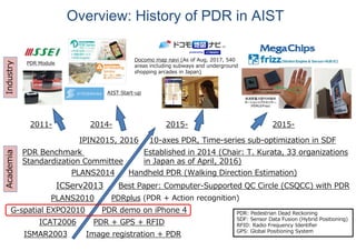
![UbiComp/ISWC 2015 PDR Challenge Corpus
• Is now open to the public. (http://hub.hasc.jp/)
19
Routes 5
Devices 7
Subjects 93
# of pedestrian sensing data 241
# of pedestrian sensing data with
calibration data
230
# of pedestrian sensing data with
LIDAR data
10
Avg. of walking time [sec] 101
Avg. of moving distance [m] 115
Avg. of angular change [°] 606
K. Kaji, M. Abe, W. Wang, K. Hiroi, and N. Kawaguchi, UbiComp/ISWC 2015 PDR challenge corpus, HASCA2016
(UbiComp2016 Proceedings: Adjunct), pp.696-704
Statistics of the corpus
Detailed route statistics of pedestrian
sensing data with calibration data](https://image.slidesharecdn.com/sc24-wg9-pdr-kurata-20170808-170808224124/85/PDR-developlent-and-PDR-Challenge-in-Warehouse-Picking-18-320.jpg)

The document discusses the development and standardization of Pedestrian Dead Reckoning (PDR) methods for navigating and tracking movement using wearable sensors. It outlines various PDR approaches, the establishment of a standardization committee in 2014, and details on multiple PDR challenges aimed at improving positioning accuracy in different environments. Key contributors and organizations involved in this research are also mentioned, emphasizing the collaborative efforts in advancing PDR technology.


![[Skolkovo Robotics V] Overview of the Modern Robotics Market](https://cdn.slidesharecdn.com/ss_thumbnails/1-170422175713-thumbnail.jpg?width=640&height=640&fit=bounds)


![[Skolkovo Robotics V] Autonomous driving: context and technical challenges of...](https://cdn.slidesharecdn.com/ss_thumbnails/presskolkovo-170506040400-thumbnail.jpg?width=640&height=640&fit=bounds)


![Sensor Fusion Study - Real World 2: GPS & INS Fusion [Stella Seoyeon Yang]](https://cdn.slidesharecdn.com/ss_thumbnails/gpsins-200817095309-thumbnail.jpg?width=640&height=640&fit=bounds)


