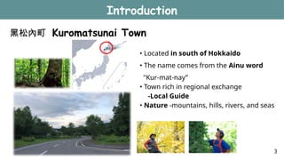
黑松內町 Kuromatsunai Town
Introduction
•Located in south of Hokkaido
• The name comes from the Ainu word
"Kur-mat-nay”
• Town rich in regional exchange
-Local Guide
• Nature -mountains, hills, rivers, and seas
3
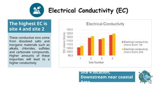
Electrical Conductivity (EC)
Thehighest EC is
site 4 and site 2
These conductive ions come
from dissolved salts and
inorganic materials such as
alkalis, chlorides, sulfides
and carbonate compounds.
Higher amounts of these
impurities will lead to a
higher conductivity
Site 4 location,
Downstream near coastal
Area 12
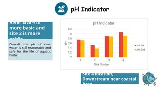
pH Indicator
River site4 is
more basic and
site 2 is more
acidic
Overall, the pH of river
water is still reasonable and
safe for the life of aquatic
biota
Site 4 location,
Downstream near coastal
Area 15
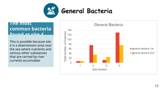
General Bacteria
The most
commonbacteria
found at site 4
This is possible because site
4 is a downstream area near
the sea where nutrients and
various other substances
that are carried by river
currents accumulate
17
21.
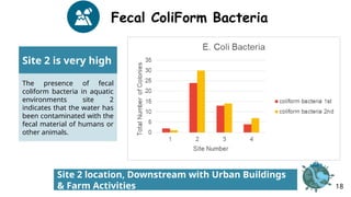
Fecal ColiForm Bacteria
Site2 is very high
The presence of fecal
coliform bacteria in aquatic
environments site 2
indicates that the water has
been contaminated with the
fecal material of humans or
other animals.
Site 2 location, Downstream with Urban Buildings
& Farm Activities 18
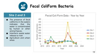
22.
Fecal ColiForm Bacteria
Site2 and 3
● The presence of fecal
coliforms in the waters
indicates that the
water is contaminated
by human or other
animal faeces.
● Interfarm waste water
release to river
● Agriculture and urban
areas
19
23.
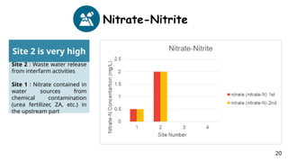
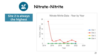
Nitrate-Nitrite
Site 2 isvery high
Site 2 : Waste water release
from interfarm activities
Site 1 : Nitrate contained in
water sources from
chemical contamination
(urea fertilizer, ZA, etc.) in
the upstream part
20
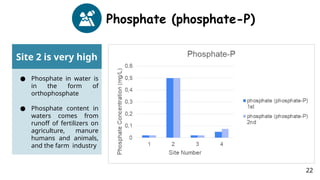
Phosphate (phosphate-P)
Site 2is very high
● Phosphate in water is
in the form of
orthophosphate
● Phosphate content in
waters comes from
runoff of fertilizers on
agriculture, manure
humans and animals,
and the farm industry
22
26.
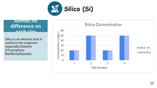
Silica (Si)
Almost no
differenceon
each site
Silica is an element that is
useful to the organism
especially Diatoms
(Chrysophyta
Bacillariophyceae)
23
27.
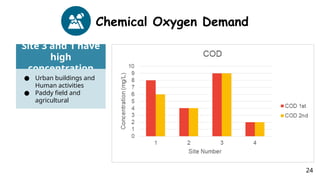
Chemical Oxygen Demand
Site3 and 1 have
high
concentration
● Urban buildings and
Human activities
● Paddy field and
agricultural
24
28.
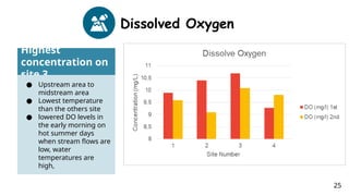
Dissolved Oxygen
Highest
concentration on
site3
● Upstream area to
midstream area
● Lowest temperature
than the others site
● lowered DO levels in
the early morning on
hot summer days
when stream flows are
low, water
temperatures are
high,
25
29.
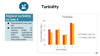
Turbidity
Highest turbidity
on site4
● Downstream area near
sea
● Accumulation of
various kinds of
organic substances
from agricultural
activities, livestock,
and urban areas
26
30.
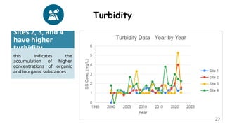
Turbidity
Sites 2, 3,and 4
have higher
turbidity
this indicates the
accumulation of higher
concentrations of organic
and inorganic substances
27
31.
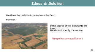
We think thepollutant comes from the farm.
However…
If the source of the pollutants are
farm,
We cannot specify the source.
Ideas & Solution
28
Nonpoint source pollution !
32.
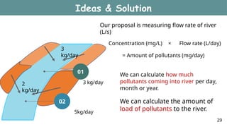
Our proposal ismeasuring flow rate of river
(L/s)
Concentration (mg/L) × Flow rate (L/day)
= Amount of pollutants (mg/day)
3 kg/day
5kg/day
We can calculate how much
pollutants coming into river per day,
month or year.
3
kg/day
02
01
2
kg/day
We can calculate the amount of
load of pollutants to the river.
Ideas & Solution
29
33.
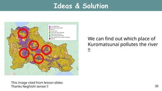
This image citedfrom lesson slides
Thanks Neghishi sensei !!
We can find out which place of
Kuromatsunai pollutes the river
!!
Ideas & Solution
30
34.
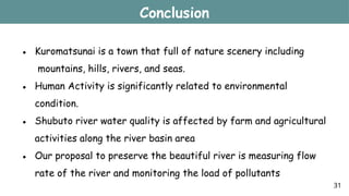
Conclusion
● Kuromatsunai isa town that full of nature scenery including
mountains, hills, rivers, and seas.
● Human Activity is significantly related to environmental
condition.
● Shubuto river water quality is affected by farm and agricultural
activities along the river basin area
● Our proposal to preserve the beautiful river is measuring flow
rate of the river and monitoring the load of pollutants
31
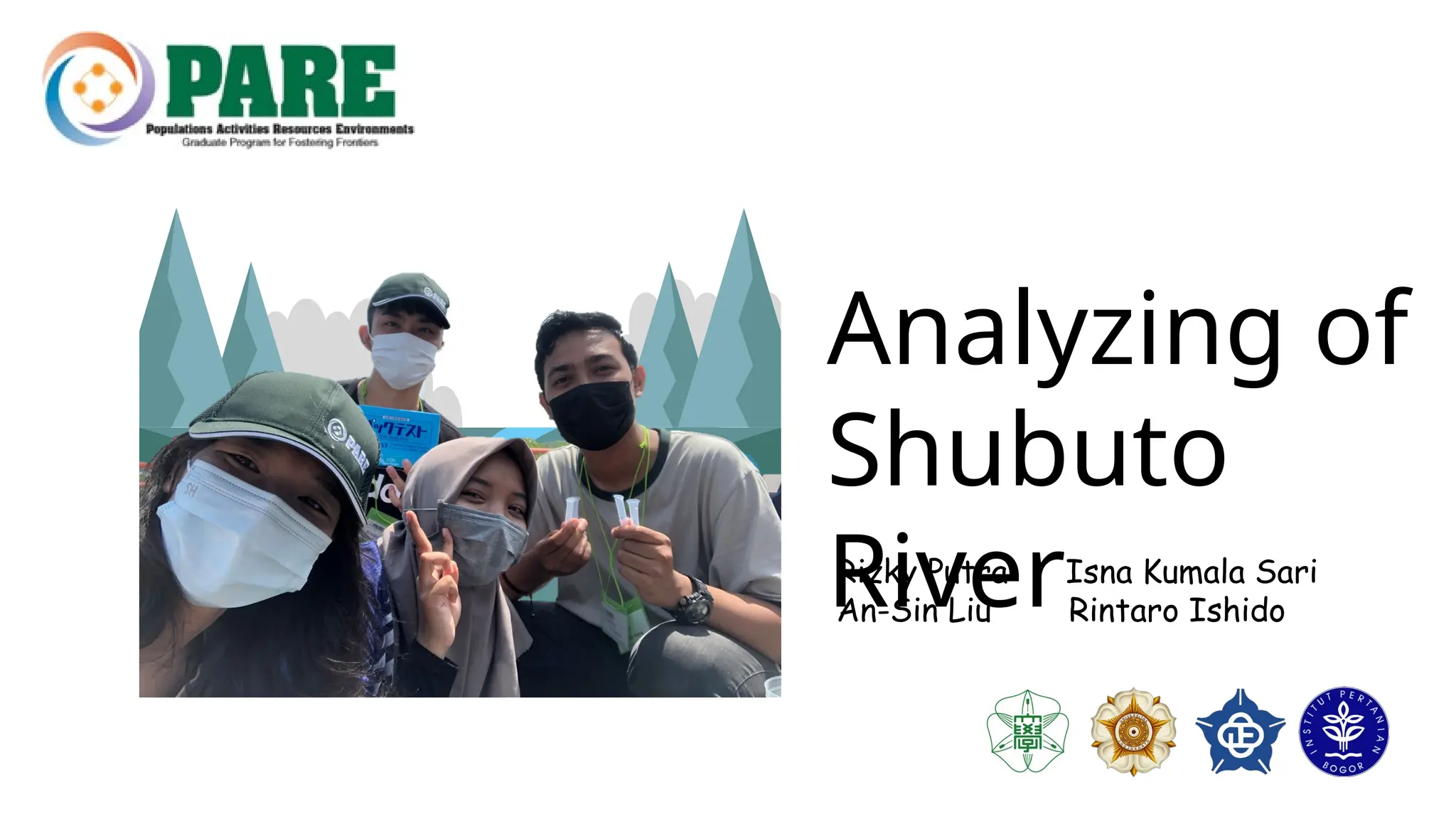
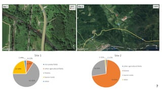
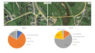
#1 Today we are going to talk about our fieldwork report:Analyzing of Shubuto River. There are my group members:XXX. Come from XXX (country) XXX university.
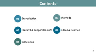
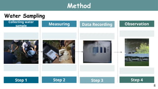
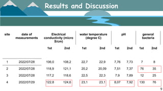
#2 These are our contents. In first part, we will do short introduction about Kuromatsunai Town and Shubuto river, including the main activity in town and site location. Second part we will introduce the methods of how we get the water sample. Third part, after we doing the test, we will show the results and compare each site of water data. In fourth part, we will come up with the solution that strengthen the resilience. Final is our conclusion.
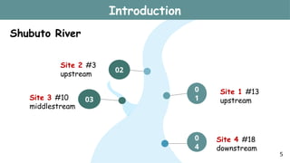
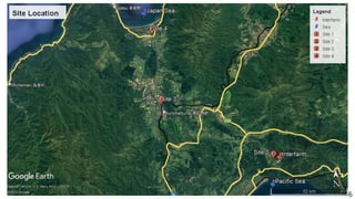
#3 First, our field place is in Kuromatsunai Town, which is located in south of Hokkaido.The town name comes from the Ainu word
"Kur-mat-nay” ,which means small river with women and people. One of the resource of Kuromatsunai town is regional exchange. There are many local guide who are the lover of Kuromatsunai Town and decided to stay there to introduce beauty of mountain. The other resource is that there are mountains, hills, Wetlands, rivers, and the seas in town.
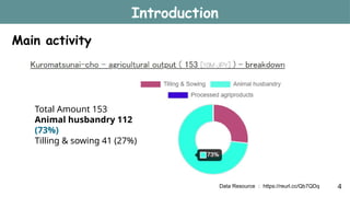
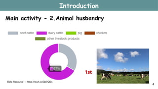
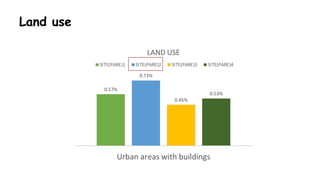
#4 There are two main activity in Kuromatsunai town. One in Tillin & sowing. The other is Animal husbandry. In the figure, we can see that Animal husbandry in green color is 73% ratio
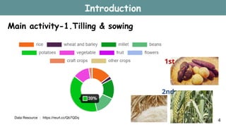
#5 In tilling and sowing industry, The major plant they grow is potato, which is the ratio in 39 percent. Second place is millet and rice.
#6 In animal husbandry, The major animal they feed is potato, which is the ratio in 67 percent. Second place is beef cattle.
#27 Chemical oxygen demand (COD) is the amount of dissolved oxygen that must be present in water to oxidize chemical organic materials
#28 Dissolved oxygen or DO (Dissolved oxygen) is the amount of dissolved oxygen in water that comes from photosynthesis and absorption of the atmosphere/air
Aquatic animals are most vulnerable to lowered DO levels in the early morning on hot summer days when stream flows are low, water temperatures are high, and aquatic plants have not been producing oxygen since sunset.
#29 Turbidity is an important indicator of the amount of suspended sediment in water, which can have many negative effects on aquatic life. The suspended sediments that cause turbidity can block light to aquatic plants, smother aquatic organisms, and carry contaminants and pathogens, such as lead, mercury, and bacteria.
#34 • Kuromatsunai is a town that full of nature scenery including mountains, hills, Shubuto rivers, and seas.


![Polymer [ बहुलक ] Chemistry Notes PDF - Irfanullah Mehar - JJ Sir Chemistry.pdf](https://cdn.slidesharecdn.com/ss_thumbnails/polymerchemistrynotespdf-irfanullahmehar-jjsirchemistry-260210172118-3f9b37f7-thumbnail.jpg?width=640&height=640&fit=bounds)


