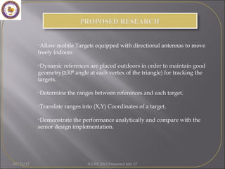
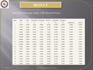
This document presents research on improving tracking accuracy for indoor situational awareness systems through dynamic movement of reference nodes. It proposes using directional antennas on mobile targets and placing reference nodes outdoors to maintain good geometry for triangulating target positions. The research aims to develop a positioning, location, and tracking algorithm based on this approach and demonstrate its performance compared to previous work. Future work plans to extend the algorithm to 3D and add node authentication. Results show the dynamic node method achieves errors as low as 0.24% without noise, increasing when noise is introduced.
1) The document analyzes raw GNSS measurement data quality from several Android smartphones.
2) It finds that Galileo code measurements are often ambiguous and GPS/GLONASS measurements have lower precision at low elevation angles, unlike with geodetic receivers.
3) Analysis of various measurement combinations like code-phase, code rate-phase rate, and double differences show effects mainly from code noise, multipath, and potential cycle slips.
This document discusses the Galileo PVT app, which provides positioning, velocity, and time solutions using Galileo and GPS satellite constellations. It retrieves ephemeris and clock data from a SUPL server and applies ionospheric corrections using the NeQuick model. The app was tested in static, pedestrian, and vehicular scenarios and provides satellite visibility information, computed positions on a map, and augmented reality views. It aims to demonstrate assisted GNSS capabilities on Android devices using Galileo signals.
Aq7275 Hướng dẫn sử dụng máy đo sợi cáp quang Yokogawa otdrMr Calvin Pham
Máy đo sợi cáp quang OTDR model AQ7275 là dòng máy đo chuẩn và chính xác trên thị trường. Tuổi thọ Pin của máy đo cao, dễ dàng thay thế và sữa chữa
tham khảo chi tiết tại : www.phukienquang.net
IJRET : International Journal of Research in Engineering and Technology is an international peer reviewed, online journal published by eSAT Publishing House for the enhancement of research in various disciplines of Engineering and Technology. The aim and scope of the journal is to provide an academic medium and an important reference for the advancement and dissemination of research results that support high-level learning, teaching and research in the fields of Engineering and Technology. We bring together Scientists, Academician, Field Engineers, Scholars and Students of related fields of Engineering and Technology.
The document discusses optical time domain reflectometry (OTDR) which is used to locate faults in optical fibers. An OTDR works by launching light pulses into a fiber and analyzing the backscattered light to map the fiber's characteristics. It can detect events like connections, bends, and breaks by analyzing reflections and loss in the returned optical signal over time. The document covers OTDR operating principles, the factors that determine its measurement resolution and event location ability, and how it is used in the industry to test fiber links and networks.
IRJET- Iot Based Underground Cable Line Fault DetectionIRJET Journal
This document describes an IoT-based system for detecting and locating faults in underground cable lines. The system uses a potential divider network laid across underground cables to detect faults. When a fault occurs, it generates a specific voltage that is sensed by a microcontroller. The location of the fault is determined by the voltage and corresponding distance in the resistor network. The microcontroller displays fault data on an LCD and transfers it online using ThingSpeak. This allows authorities to monitor cables and locate faults remotely via the internet. The system aims to quickly and easily detect fault locations without having to manually inspect the entire underground line.
Energy Smart Apps - Location-aware algorithms to save energy on mobile devicesSean Barbeau
The document describes several location-aware algorithms that can save energy on mobile devices:
1) A GPS Auto-Sleep algorithm dynamically adjusts the GPS sampling interval based on user movement speed and distance thresholds to reduce battery usage and data transfer.
2) A Critical Point Algorithm filters real-time GPS data on the mobile device before transmission, eliminating non-essential points to further reduce energy and data.
3) The algorithms were tested on mobile devices and shown to double battery life on average while maintaining high accuracy of location data for applications.
- GNSS raw measurements from Android phones can provide centimeter-level accuracy with dual-frequency receivers and techniques like PPP.
- Tools are available for logging raw GNSS data from Android phones and performing analysis on the logged data, including analyzing errors from ionosphere, troposphere, and signal-in-space.
- Future applications of high-accuracy GNSS from phones include jamming detection, carrier-phase positioning for apps requiring precise location, and signal analysis for effects like ionosphere and multipath.
The Al Noor-Samsung Hope for Children Fun Fair was held on February 25, 2011 at the Al Noor Training Centre for Children with Special Needs to raise funds for the Centre. Over 5,000 people attended the event. As title sponsor, Samsung received exclusive branding and promotional opportunities including naming rights, logo placement, and stands where they provided activities and raffle prizes. The event was a success, raising 200,000 dirhams through raffle ticket sales to support programs for children at the Centre.
This document is the introduction chapter to the book "KingdomNomics" which discusses applying biblical financial principles. It introduces the concept of KingdomNomics as studying principles that define value from God's perspective. The chapter discusses that people's futures can be predicted by their "leading indicators," and this book focuses on the leading indicators for one's life. It outlines that KingdomNomics prioritizes eternity over temporary pleasures and requires having God as our ruler. The introduction sets up that the book will discuss strategic application of time, talents, and treasures according to biblical principles.
The US military suffers from PowerPoint addiction. A recent publication of a confusing slide on US military strategy in Afghanistan offered a proof. PowerPoint can explain each and every complex situation in life - with one single slide ...
Este documento resume los conceptos clave de la poesía lírica, incluyendo el motivo lírico, el hablante lírico, tipos de rima, versos y estrofas. También describe cómo elaborar una poesía propia y las actividades de la clase, que incluyen escribir un poema y desarrollar una guía de trabajo.
Hospitality Industry in Tanzania_HAT Presentation to Hon. Minister Prof Rev1SW Associates, LLC
This document summarizes a meeting between the Hotels Association of Tanzania (HAT) and the Ministry of Natural Resources & Tourism. HAT represents 119 member facilities with over 5,000 rooms. Tourism in Tanzania is growing, but high taxes and fees mean much money leaves the country after visitors arrive. HAT requests solutions to make the industry more profitable so it can continue growing jobs and the economy. The government is considering tax reforms to support sustainability and competitiveness. Opportunities exist to develop coastal and southern tourism circuits and expand visits to Wildlife Management Areas.
This document discusses nonlinear regression analysis and comparing different statistical techniques for linear and nonlinear models.
It introduces nonlinear regression, where observational data is modeled by a nonlinear combination of parameters and independent variables. Some nonlinear problems can be transformed into linear models through suitable transformations.
The document then applies various statistical techniques - least squares estimation, Fisher's F-test, and Student's t-test - to linear and exponential nonlinear regression models. It compares the results of these techniques on sample images of different sizes, finding that Fisher's F-test for nonlinear models is more accurate on smaller areas, while the accuracy decreases for larger sample sizes. Overall, the nonlinear t-test performs better than the linear t-test for extracting lesions,
Localization of wireless sensor networkIRJET Journal
This document summarizes a range-free localization algorithm for wireless sensor networks called TSBMCL (Temporary-Seed Based Monte Carlo Localization) that uses the Monte Carlo method. It discusses how TSBMCL works in two main parts: 1) voting for temporary anchor nodes from localized nodes, and 2) using the temporary anchors to aid localization of other nodes. The algorithm is shown to improve localization accuracy over the MCB algorithm. Simulation results demonstrate that TSBMCL reduces localization failure rates and requires fewer sampling particles than standard Monte Carlo localization methods. In conclusion, TSBMCL provides an accurate and efficient range-free localization scheme for mobile wireless sensor networks.
This document describes an event data recorder (EDR) system for automobiles. The EDR would record vehicle data during and after an accident using sensors like accelerometers and gyroscopes. If an accident is detected, it would send an alert message with the vehicle's location to pre-stored contacts. This would help provide faster medical assistance. The proposed low-cost EDR system aims to record important vehicle parameters without being too expensive to implement in all vehicles like a traditional "black box". It could help determine the causes of accidents and assist insurance companies and police investigations.
This document is a report from AUSPOS, an online GPS processing service. It processed GPS data from January 7, 2017 to determine precise coordinates for the user's site in both the international ITRF2008 and Australian GDA94 reference frames. The report provides details on the processing including the reference stations used, computed coordinates, positional uncertainties, and standards followed in processing the GPS data.
IRJET- Wearable Sensor Fall Detection SystemIRJET Journal
This document summarizes a research paper on a wearable sensor fall detection system. The system uses a 3-axis accelerometer sensor worn on the waist to detect falls. When a fall is detected, the system uses GSM and GPS modules to locate the person and alert others by triggering an alarm. The objectives are to design a fall detection system for elderly people. The system includes an accelerometer, Arduino board, LCD display, transistor, buzzer, power supply, level converter, GPS modem, and GSM modem. The conclusion is that accelerometers provide accurate fall detection results and are an effective way to detect falls and summon help for the elderly.
IRJET - A Real-Time Pothole Detection Approach for a Safety Transportation Sy...IRJET Journal
This document proposes a real-time pothole detection system to improve transportation safety. The system uses an accelerometer sensor to detect potholes by measuring deviations in road surface acceleration. An onboard GPS module provides the location of detected potholes. This location data, along with light and noise readings from an LDR and microphone, is uploaded to the cloud and plotted on Google Maps. The goal is to reduce accidents caused by unexpected potholes by making drivers aware of their locations.
The document provides guidance on using total station equipment for topographic surveys. It discusses the features and operation of total stations, which combine electronic theodolites and distance measurement instruments. Total stations allow large amounts of survey data to be collected quickly and efficiently compared to traditional methods. The document outlines considerations for equipment selection and inventory, including total station models, data collectors, batteries, and maintenance procedures to ensure equipment remains calibrated and in good working condition.
This document describes a smart car system that uses various sensors and a microcontroller to address common problems faced while driving such as road blocks, potholes, speed bumps, and vehicle theft. The proposed system uses an Arduino Mega microcontroller along with ultrasonic sensors, a sound sensor, GSM and GPS modules, an RF module, and an LCD to provide features like speed bump detection, pothole detection, parking assistance, and vehicle tracking. The system is intended to help make travel safer and less stressful by anticipating hazards and providing guidance.
IRJET- Study of Real Time Kinematica Survey with Differential Global Position...IRJET Journal
1) The document discusses using real time kinematic (RTK) surveying with differential global positioning systems (DGPS) to improve surveying accuracy from 15 meters to 10 centimeters.
2) RTK uses a fixed base station that transmits correction data to a rover to reduce positioning errors. Accuracy is improved up to 20km from the base station.
3) The study involved taking 27 point readings using RTK surveying in Tippani and creating an AutoCAD plan from the DGPS data to compare accuracy and efficiency to traditional surveying methods. DGPS was found to be faster, reduce human error, and only require open sky versus line of sight for total stations.
Demystifying OTDR Event Analysis CCTA Presentation 070714.pdfMani Kandan K
This training presentation introduces OTDR event analysis. It discusses how OTDRs work by launching light pulses into fiber and measuring backscatter. It covers OTDR fundamentals like pulse width, averaging, and signal-to-noise ratio. The presentation teaches how to analyze events like splices and reflections to determine distances, losses, and other issues. Both manual and automatic event analysis techniques are described. The goal is to help users of all experience levels understand OTDR results.
IRJET- Under Water Optical Wireless CommunicationIRJET Journal
This document discusses underwater optical wireless communication (UWOC). It begins with an abstract that outlines the challenges of UWOC such as attenuation, scattering, and turbulence. It then provides an introduction to different modulation techniques used in UWOC like on-off keying, digital pulse interval modulation, and polarized digital pulse interval modulation. The rest of the document describes a simulation of a UWOC link using different parameters like bit rate, distance, power, and wavelength. It analyzes the impact of distance on the quality factor and bit error rate. The conclusion is that increasing distance leads to more signal distortion and lower quality communication.
Survey Paper for Different Video Stabilization TechniquesIRJET Journal
This document summarizes and compares three video stabilization techniques: Scale Invariant Feature Transform (SIFT), Speeded Up Robust Features (SURF), and block-based methods. SIFT extracts distinctive keypoints from videos that are invariant to scale and rotation, but it is computationally slow. SURF is faster than SIFT and also extracts robust features. Block-based methods partition video frames into macroblocks and estimate motion between frames by block matching, using metrics like mean absolute difference. It has lower complexity than SIFT and SURF but provides good stability for video stabilization. The document analyzes the performance of these techniques and their application in video stabilization.
Here are the details of the major components used in the circuit:
28
6.1 POWER SUPPLY:
The power supply unit is used to provide a constant 5V supply to different ICs. It uses a 12V DC battery as input which is connected to a voltage regulator IC 7805 to provide a regulated 5V DC output. A diode is added in series to avoid reverse voltage damage to the regulator. Capacitors are added at the input and output of the regulator for voltage regulation.
6.2 MICROCONTROLLER (AT89C51):
AT89C51 is a low-power, high-performance CMOS 8-bit microcontroller with 4K bytes of flash program
The document discusses the design and analysis of three fractal antennas. The first is a hybrid fractal antenna combining elements of the Sierpinski carpet and Giuseppe Peanu fractals, allowing for narrow-band operation in the S-band. The second is a multi-band fractal antenna created through an iterative process of cutting circles out of squares, enabling it to resonate at five frequencies from 3-12 GHz. The third is an ultra-wide band fractal antenna made by cutting hexagonal holes in a circular patch through five iterations, optimized using parametric analysis. Dimensions, resonant frequencies, radiation patterns, and gains are analyzed for each antenna. Fractal geometry is shown to increase electrical length while
Indoor & outdoor distance sensing mobile robotzolofy
This document describes a project to develop indoor and outdoor distance sensing for a mobile robot. The objectives are to use a quadrature encoder for indoor distance sensing of a differentially driven robot and interpret GPS data for outdoor navigation. It outlines the hardware and software development processes for both systems, including wiring diagrams. It presents testing results for the quadrature encoder and GPS module that show distance and position measurement accuracy within a few millimeters. The document concludes that the objectives were achieved and recommends further research on the quadrature encoder and additional hardware for more efficient robot operation.
“Head of real time and back office systems in operation”IMDEA Energia
The document discusses smart grids from the perspective of distribution networks. It begins with an introduction and overview of smart grids. It then discusses the current state of distribution networks and energy sources. Next, it outlines a proposed roadmap for smart grids with five stages: 1) advanced metering infrastructure, 2) distributed generation integration, 3) advanced demand management, 4) optimization and coordination of the overall system, and 5) tiempo gestión inteligente de la red. It also discusses ancillary services and the potential role of distributed energy resources. Finally, it concludes that smart grids could provide benefits like increased efficiency, reliability, security of supply, and flexibility through technologies like smart metering, monitoring, and demand response.
FAULT DETECTION SCHEME OF 5 BUS BY ANN AND ANFISIRJET Journal
This document proposes a fault detection scheme for a 5 bus system using artificial neural networks (ANN) and adaptive neuro-fuzzy inference systems (ANFIS). The scheme involves using discrete wavelet transform (DWT) to preprocess current and voltage measurements and extract statistical features. These features are then input into three ANNs/ANFIS models for fault classification, identification of fault phase, and detection of fault location. Simulation results on the 5 bus system demonstrate the effectiveness of the proposed scheme in accurately detecting fault type, phase and location in a fast and robust manner compared to previous methods.
IRJET- Development and Monitoring of a Fall Detection System through Wear...IRJET Journal
This document summarizes a research paper that developed and monitored a fall detection system using a wearable sensor belt. The system uses an IoT-based technology with a wearable belt containing an accelerometer to detect falls in elderly patients. When a fall is detected, it sends an alert to caregivers and also senses the location using GPS. The accelerometer data is sent to the cloud for monitoring visually using VPython. The system aims to quickly detect falls and send alerts to caregivers to allow for faster medical treatment and reduce health risks for elderly fall victims.
Adaptive Hyper-Parameter Tuning for Black-box LiDAR Odometry [IROS2021]KenjiKoide1
Adaptive Hyper-Parameter Tuning for Black-box LiDAR Odometry
Kenji Koide, Masashi Yokozuka, Shuji Oishi, and Atsuhiko Banno
Proc. IEEE/RSJ International Conference on Intelligent Robots and Systems (IROS2021), pp. 7708-7714, Prague, Czech Republic, Sep., 2021
https://staff.aist.go.jp/k.koide/
Remote sensing –Beyond images
Mexico 14-15 December 2013
The workshop was organized by CIMMYT Global Conservation Agriculture Program (GCAP) and funded by the Bill & Melinda Gates Foundation (BMGF), the Mexican Secretariat of Agriculture, Livestock, Rural Development, Fisheries and Food (SAGARPA), the International Maize and Wheat Improvement Center (CIMMYT), CGIAR Research Program on Maize, the Cereal System Initiative for South Asia (CSISA) and the Sustainable Modernization of the Traditional Agriculture (MasAgro)
Secure Image Encryption using Two Dimensional Logistic Map
* Gangadhar Tiwari1, Debashis Nandi2, Abhishek Kumar3, Madhusudhan Mishra4 1, 2Department of Information Technology, NIT Durgapur (W.B.), India 3Department of Electronics and Electrical Engineering, NITAP, (A.P.), India 4Department of Electronics and Communication Engineering, NERIST, (A.P.), India
Non-Invertible Wavelet Domain Watermarking using Hash Function
*Gangadhar Tiwari1, Debashis Nandi 2, Madhusudhan Mishra3
1,2 IT Department, NIT, Durgapur-713209, West Bengal, India,
3ECE Department, NERIST, Nirjuli-791109, Arunachal Pradesh, India,
Converting UML class diagram with anti-pattern problems to verified code based on Event-B
Eman K. Elsayed
Mathematical and computer science Dep., Faculty of Science,
Al-Azhar University, Cairo, Egypt
Approach to Seismic Signal Discrimination based on Takagi-Sugeno Fuzzy Inference System
E. H. Ait Laasri, E. Akhouayri, D. Agliz, A. Atmani Electronic, Signal processing and Physical Modelling Laboratory, Physics’ Department, Faculty of Sciences, Ibn Zohr University, B.P. 8106, Agadir, Morocco
Unit Commitment Using a Hybrid Differential Evolution with Triangular Distribution Factor for Adaptive Crossover
N. Malla Reddy* K. Ramesh Reddy** and N. V. Ramana***
Intelligent e-assessment: ontological model for personalizing assessment activities
Rafaela Blanca Silva-López1, Iris Iddaly Méndez-Gurrola1, Victor Germán Sánchez Arias2
1 Universidad Autónoma Metropolitana, Unidad Azcapotzalco.
Av. San Pablo 180, Col. Reynosa Tamaulipas, Del. Azcapotzalco, México, D.F.
2 Universidad Nacional Autónoma de México
Circuito Escolar Ciudad Universitaria, 04510 México, D.F.
Visual Perception Oriented CBIR envisaged through Fractals and Presence Score
Suhas Rautmare, Anjali Bhalchandra
A. Tata Consultancy Services, Mumbai B. Govt. College of Engineering, Aurangabad
Measuring Sub Pixel Erratic Shift in Egyptsat-1 Aliased Images: proposed method
1M.A. Fkirin, 1S.M. Badway, 2A.K. Helmy, 2S.A. Mohamed
1Department of Industrial Electronic Engineering and Control, Faculty of Electronic Engineering,
Menoufia University, Menoufia, Egypt.
2Division of Data Reception Analysis and Receiving Station Affairs, National Authority for Remote Sensing and Space Sciences, Cairo, Egypt.
The State of the Art of Video Summarization for Mobile Devices:
Review Article
Hesham Farouk *, Kamal ElDahshan**, Amr Abozeid **
* Computers and Systems Dept., Electronics Research Institute, Cairo, Egypt.
** Dept. of Mathematics, Computer Science Division,
Faculty of Science, Al-Azhar University, Cairo, Egypt.
Overwriting Grammar Model to Represent 2D Image Patterns
1Vishnu Murthy. G, 2Vakulabharanam Vijaya Kumar
1,2Anurag Group of Institutions, Hyderabad, AP,India.
Texture Classification Based on Binary Cross Diagonal Shape Descriptor Texture Matrix (BCDSDTM)
1P.Kiran Kumar Reddy, 2Vakulabharanam Vijaya Kumar, 3B.Eswar Reddy
1RGMCET, Nandyal, AP, India, 2Anurag Group of Institutions, Hyderabad, AP, India
3JNTUA College of Engineering, India.
Improved Iris Verification System
Basma M.Almezgagi, M. A. Wahby Shalaby, Hesham N. Elmahdy Faculty of Computers and Information, Cairo University, Egypt.
The document proposes a new model called the Simple Connected Pattern Array Grammar (SCPAG) that is capable of generating and recognizing complex connected patterns in an image neighborhood. SCPAG aims to address the difficulty of representing all possible connected patterns on even a small 3x3 neighborhood using existing methods. The paper introduces SCPAG as a way to efficiently generate and recognize patterns by properly describing the pattern set with a uniquely parsable array grammar.
Bench Marking Higuchi Fractal for CBIR
A. Suhas Rautmare, B. Anjali Bhalchandra
A. Tata Consultancy Services, Mumbai B. Govt. College of Engineering, Aurangabad
The document discusses the performance of Flexible AC Transmission System (FACTS) devices on voltage stability in a deregulated power system. It focuses on enhancing voltage stability using FACTS controllers like Static Var Compensator (SVC) and Thyristor-controlled series capacitor (TCSC). The optimal location of FACTS devices is determined using sensitivity methods. The effectiveness of the proposed method is demonstrated on a modified IEEE-9 bus system using PowerWorld simulator 8.0.
This document summarizes a numerical study of automatically controlling and stabilizing the pulse repetition rate of passively Q-switched laser systems. The researchers propose a technique called automatic pulsed pumping that detects generated Q-switched pulses and alters the pumping power accordingly. By simulating a diode-pumped Yb:YAG laser with Cr4+:YAG as a saturable absorber using rate equations, the technique showed good control over pulse repetition rate with high stability, allowing for both high rates like pulsed pumping and stability like continuous pumping.
The document analyzes and compares the movement of metallic particles in SF6/N2, SF6/CO2, and SF6/Air gas mixtures used in gas insulated substations. It finds that SF6 has a nonlinear breakdown strength affected by metallic particles, and is also a greenhouse gas. Alternative gas mixtures are needed. The paper presents results on particle movement in these three gas mixtures as potential SF6 alternatives with good dielectric properties.
This paper discusses suppressing transformer inrush current when connecting to a PWM voltage source converter. It compares this technique to using PI control of DC voltage. The PWM converter acts as a resistor for source current, eliminating inrush. Inrush suppression principles and varying magnetizing current with control gains are examined. Both methods were developed and simulated in MATLAB/SIMULINK. The paper aims to confirm the validity of using a PWM converter to suppress transformer inrush current when connecting to the source.
This document summarizes a paper that investigates the robustness of linear time-invariant state observers when state and measurement variations occur. The paper applies observer theory to an internal combustion engine model and analyzes how state and sensor disturbances affect observer error dynamics and performance robustness. It was authored by S.O. Omekanda from Oakland University, T. Perkins from Oakland University, and M.A. Zohdy from Oakland University.
The document summarizes a two-branch parallel RC circuit Simulink model of a lithium polymer battery. The model parameters depend on temperature and state of charge, which are represented using 2D lookup tables. User-defined functions calculate open circuit voltage and internal resistance. A dedicated block autonomously detects charge/discharge transitions and resets the current integrator. Comparisons to experimental data show maximum errors of 3% for dynamic responses and 5% for static discharging responses.
1. Electrical and Computer Engineering Department
Roy G. Perry College of Engineering, Prairie View A&M University,
Prairie View, TX
By
Dr. Warsame H. Ali
DYNAMIC MOVEMENT OF REFERENCE NODES,
FOR IMPROVED TRACKING ACCURACY OF
INDOOR SITUATIONAL AWARENESS SYSTEMS
DYNAMIC MOVEMENT OF REFERENCE NODES,
FOR IMPROVED TRACKING ACCURACY OF
INDOOR SITUATIONAL AWARENESS SYSTEMS
07/22/15 ICGST 2012 Presented July 17
2. OUTLINEOUTLINE
Problem Statement
Overview
Scope
Background
Proposed research
Result Analysis
Conclusion
Future work
07/22/15 ICGST 2012 Presented July 17
3. PROBLEM STATEMENTPROBLEM STATEMENT
• Design a Position, Location and Tracking(PL&T) algorithm based on
dynamic references for Indoor Situational Awareness System
07/22/15 ICGST 2012 Presented July 17
4. 07/22/15 ICGST 2012 Presented July 17
• GPS have been traditionally used for Position, Location and Tracking
(PL&T) but In several cases, GPS tends to be inaccurate in indoor
situations.
• It also tends to be inaccurate near buildings(accuracies of 20 meters)
• A self-configuring network, Mobile Ad hoc Network (MANET) is used
for robust prediction and tracking in indoor situational awareness
systems (ISM).
• Researchers have looked into the implementation of MANET using
various schemes. A common scheme is triangulation.
5. 07/22/15 ICGST 2012 Presented July 17
• Indoor PL&T algorithm using dynamic references
6. This project is a follow up on two previous work done in Prairie View
A&M University.
The senior design team at Prairie View A&M University was
saddled with the task of designing a PL&T algorithm. They came
up with the “Panther Tracker”, that uses autonomous time and
speed movement to estimate the range of a robot from its previous
position
A dissertation by “Niraj “on Antennas, Dynamic PL&T and the
security of the system
07/22/15 ICGST 2012 Presented July 17
7. • In estimating the distance of a node
from its neighbor, the node can use the
time of flight, attenuation of signal
strength or directionality of a signal
emanating from its neighbor.
LOCATION ESTIMATION TECHNIQUESLOCATION ESTIMATION TECHNIQUES
• Traditional methods of Estimation are
triangulation, scene analyses and proximity
• Triangulation remains the most commonly used
method with the other methods used mainly to
improve its accuracy.
• Triangulation relies on the geometric properties
of triangles to estimate the location of a target
node
• Lateration triangulation-distance measurements
• Angulation triangulation-angle measurements in
combination
R2
R1
R3
θ
d
β
MS
BS BS
Lateration
Angulation
07/22/15 ICGST 2012 Presented July 17
8. • Difficult to implement
• Due to accuracy limitations
stemming from lack of stable clock
and random delays from contention
method in IEEE 802.11 wireless
LAN, this design method was
stopped for demonstration.
TOD/TOA APPROACHTOD/TOA APPROACH
• Di is computed using TOD and
TOA roundtrip measurement
• For each triangle, two ranges are
computed for each Di and take the
average to get D1, D2, D3.
• With known Di and reference (x, y),
• The coordinate of the target(T) can
be calculated using each triangle.
• For close values of (x, y), take the
average of the three (x, y)s
• For two close value and one off-
valued result, take the average of
the close results
• For three off-value results, repeat
measurement.
07/22/15 ICGST 2012 Presented July 17
9. DIRECTIONAL ANTENNADIRECTIONAL ANTENNA
• Realized by using the beamforming
technology together with an antenna
array
• Transmit beamforming-when
implemented at Tx only
• Receive beamforming-when
implemented at Rx only
• Joint transmit and receive
beamforming-when implemented at Tx
& Rx
θ
z
x
y
07/22/15 ICGST 2012 Presented July 17
10. • Directional antennas have a longer transmission range
• reducing delay and increase in connection throughput
• Directional antenna also possess larger free channel space
around the transmitting node and allows more concurrent
transmission without collisions
• A two element directional antenna was found to consume
approximately 7% of the power of the omnidirectional
antenna while a four-element antenna comes just 1%.
• Used in Cellular networks such as GSM and infrastructure
WLAN
WHY USE DIRECTIONAL
ANTENNA ?
WHY USE DIRECTIONAL
ANTENNA ?
07/22/15 ICGST 2012 Presented July 17
11. MULTIPATH FADED CHANNELMULTIPATH FADED CHANNEL
• Occur when plane waves arriving at the
MS/BS from the MS/BSs with random
phases and combine vectorially at the
receiver
• Multipath-fading results in rapid
variations in the envelope of the
received signal at the MS/BS
Multipath causes difference in propagation
lengths which results in amplitude and
phase fluctuations and time delay in the
received signal
Rayleigh fading occurs when the
multiple reflective paths are large in
number and there is no LOS signal
component
When Multipath-fading has a dominant
LOS, it can be modeled by the Rician
distribution
the envelope of the received
signal is described statistically as
Rayleigh distribution.
07/22/15 ICGST 2012 Presented July 17
12. 07/22/15 ICGST 2012 Presented July 17
•Allow mobile Targets equipped with directional antennas to move
freely indoors
•Dynamic references are placed outdoors in order to maintain good
geometry(≥30 angle at each vertex of the triangle) for tracking the⁰
targets.
•Determine the ranges between references and each target.
•Translate ranges into (X,Y) Coordinates of a target.
•Demonstrate the performance analytically and compare with the
senior design implementation.
14. FLOW MODEL FOR DYNAMIC
MOVEMENT OF REFERENCES
FLOW MODEL FOR DYNAMIC
MOVEMENT OF REFERENCES
07/22/15 ICGST 2012 Presented July 17
15. α
µ
θ
β
DYNAMIC NODES WITH DIRECTED BEAMDYNAMIC NODES WITH DIRECTED BEAM
07/22/15 ICGST 2012 Presented July 17
16. LATERATION WITH MOBILE NODESLATERATION WITH MOBILE NODES
The system is then solved using the least square approch
Lateration equation
07/22/15 ICGST 2012 Presented July 17
22. • Future work will be the development of a 3 dimensional
algorithm for PL&T in an indoor situational awareness
system.
• Another part of the proposal will be nodal
authentications.
FUTURE WORKFUTURE WORK
CONCLUSIONCONCLUSION
• Dynamic movement of reference nodes improves the
accuracy of PL&T estimation
• Considerable improvement over the Autonomous time
and speed movement to estimate the range of the robot
from its previous position used by the senior design
group
• Offers error as low as 0.24 percent in a noiseless system.
This error increases when with introduction of noise
into the system
• Unbounded AOA, error has ben proven to be as high as
7.46 percent
07/22/15 ICGST 2012 Presented July 17
23. • Rong, P; Sichitiu, M.L.; "Angle of Arrival Localization for Wireless Sensor Networks," Sensor and Ad Hoc
Communications and Networks, 2006. SECON '06. 2006 3rd Annual IEEE Communications Society on , vol.1,
no., pp.374-382, 28-28 Sept. 2006
• Jun Xu; Maode Ma; Choi Look Law, "AOA Cooperative Position Localization," Global Telecommunications
Conference, 2008. IEEE GLOBECOM 2008. IEEE , vol., no., pp.1-5, Nov. 30 2008-Dec. 4 2008
• Langendoen, K. “Distributed localization in wireless sensor networks: a quantitative
comparison.” Computer Networks 43.4 (2003): 499-518.
Yiu-Tong Chan; Wing-Yue Tsui; Hing-Cheung So; Pak-chung Ching; , "Time-of-arrival based localization under
NLOS conditions," Vehicular Technology, IEEE Transactions on , vol.55, no.1, pp. 17- 24, Jan. 2006
Capkun, S.; Hamdi, M.; Hubaux, J.-P.; , "GPS-free positioning in mobile ad-hoc networks," System Sciences, 2001.
Proceedings of the 34th Annual Hawaii International Conference on , vol., no., pp. 10 pp., 3-6 Jan. 2001
Riter, S.; McCoy, J.; , "Automatic vehicle location—An overview," Vehicular Technology, IEEE Transactions on ,
vol.26, no.1, pp. 7- 11, Feb 1977
Figel, W.G.; Shepherd, N.H.; Trammell, W.F.; , "Vehicle location by a signal attenuation method,"Vehicular
Technology Conference, 1968. 19th IEEE , vol.19, no., pp. 105- 109, 1968
Hata, M.; Nagatsu, T.; , "Mobile location using signal strength measurements in a cellular system," Vehicular
Technology, IEEE Transactions on , vol.29, no.2, pp. 245- 252, May 1980
Hüseyin Akcan , Vassil Kriakov , Hervé Brönnimann , Alex Delis, GPS-Free node localization in mobile
wireless sensor networks, Proceedings of the 5th ACM international workshop on Data engineering for
wireless and mobile access, June 25-25, 2006, Chicago, Illinois, USA
Kułakowski P, Vales-Alonso J, Egea-Lopez E, Ludwin W, Garcia-Haro J. Angle-of-arrival localization
based on antenna arrays for wireless sensor networks. In: Elsevier computers and electrical engineering
journal, vol.36(6); 2010. p. 1181–6
Riter, S.; McCoy, J.; , "Automatic vehicle location—An overview," Vehicular Technology, IEEE Transactions
on , vol.26, no.1, pp. 7- 11, Feb 1977
S. Yi, Y. Pei and S. Kalyanaraman, “On the capacity improvement of ad hoc wireless networks using
directional antennas,” MobiHoc2003.
L. Tong et al., “Energy efficient multicasting using smart antennas for wireless ad hoc networks in
multipath environments,” Globeome 2004.
REFERENCESREFERENCES
07/22/15 ICGST 2012 Presented July 17