4. zycnzj.com/ www.zycnzj.com
CONTENTS
Introduction............................................................................1
History of the County..........................................................3
Principal Historic Events..................................................21
Official Symbols
Montgomery County Emblem ............................. 23
Coat of Arms .......................................................... 23
County Bird and Blossom .................................... 24
Flag of Montgomery County................................ 25
County Executives and
Council Members, Past to Present...................26
County Demographics......................................................29
zycnzj.com/http://www.zycnzj.com/
5. zycnzj.com/ www.zycnzj.com
INTRODUCTION
Montgomery County is proud of its history. From Indian
stone quarries and trails to present day high technology
centers, it has played an integral part in the develop-
ment of this country. By settling the frontier in the
1700s, supporting independence, and ceding
Georgetown for the new capital, the county and its
citizens have played an active and important role in the
formation of the United States.
Montgomery County has changed, evolving from a
region of farming communities into a vital force in the
metropolitan urban area. Major forces of change have
been the Civil War, the B&O Railroad, World War II, the
growth of the federal government and the technological
explosion. Since the 1940s, the county’s population has
grown exponentially and in the process has become
multi-cultural, with residents coming from all parts of the
world.
While this book gives us facts and figures, it is people
who make a difference. We are concerned citizens
working to improve the county for succeeding genera-
tions, remembering that it is our history that gives us a
sense of place and community.
Mary Anne Tuohey
President,
Montgomery County Historical Society
zycnzj.com/http://www.zycnzj.com/
7. zycnzj.com/ www.zycnzj.com
HISTORY OF MONTGOMERY COUNTY
More than 300 years ago when the first European
settlers arrived in what is now Montgomery County, an
area stretching from the mouth of Rock Creek in the
south to the Monocacy River in the north, the Potomac
River on the west and the Patuxent River on the east,
they found evidence of occupation by Indians of the
Piscataway Confederation. It was a beautiful forested
area rich in game that included deer, buffalo, bear and
wild turkey, with rivers and streams teaming with fish.
Captain John Smith of Virginia explored the Potomac
River in 1608, and was the first European to map the area.
The first to colonize the area were from England, Ireland
and Wales. The first patent for land was recorded in
1688 for a tract along the banks of Rock Creek. Once
here, the settlers quickly cleared much of the virgin
forest to grow tobacco and food, and build homes.
Early Lifestyles 3
The first homes were one or two room cabins, with a
loft. Often, a separate building housed the kitchen and
slaves. Later, homes of brick and stone appeared. The
more prosperous farms often included barns, a spring
house, smoke house and slave quarters. There were a
few elaborate homes with carved mantels, high ceilings
and imported furniture. Apple orchards were common
and the colonial cellar was stocked with produce from
the farm.
In 1695, the land that now encompasses Montgomery,
Prince George’s and Frederick counties, as well as
Washington, D.C., was designated as Prince George’s
County. The area was divided in 1 748 and the western
portion—including the land that would ultimately be
Montgomery—became Frederick County. On August 31,
1776, Dr. Thomas Sprigg Wootton, a member of the
Maryland Constitutional Convention, introduced a bill to
divide Frederick into three counties—Frederick, Mont-
gomery and Washington. The bill passed on September
6, 1776. These were the first counties in America to be
established by elected representatives. The names
selected for the new counties also broke with tradition.
Earlier counties had all been named for old world figures
zycnzj.com/http://www.zycnzj.com/
8. zycnzj.com/ www.zycnzj.com
such as Prince George and Queen Anne, but these were
named after two popular Americans of the time—George
Washington and Richard Montgomery.
Origin of Names
Richard Montgomery was born on December 2, 1738 in
Raphoe, Ireland. At 18 he was commissioned as an
officer in the British army and fought in the French and
Indian Wars, before emigrating to America in 1772. He
was commissioned a brigadier general in the fledgling
colonial army and he commanded an expeditionary force
sent to Canada that captured Montreal. On December 4,
1775 his forces laid siege to Quebec. Although his troops
were greatly outnumbered, he led several daring attacks
on the fortress. On December 31, he was killed by
cannon fire. Montgomery never set foot in the Maryland
county that bears his name.
4
Many family names appear on the map of the County,
the legacy of early settlers. They include: Layton, Clarke,
Poole, Hyatt, Neel, Browning, Clagett, King, Dawson,
White, Dickerson, Spencer, Burton, Darne, Brooke and
Gaither.
Germantown got its name from German settlers who
moved there from Pennsylvania. Seneca was named
after the Indian tribe. Bethesda derives its name from
the Presbyterian Bethesda Meeting House built there.
When Montgomery County was established, the State
appointed commissioners to buy four acres of land for a
courthouse and jail. The place they selected was first
called Montgomery Courthouse, and then became known
as Williamsburg. Eventually, it became Rockville, taking
its name from Rock Creek.
zycnzj.com/http://www.zycnzj.com/
9. zycnzj.com/ www.zycnzj.com
Early Federal Period
When it was first selected to be the County seat, the
community that would become Rockville consisted of
about a half dozen buildings, at a crossroads on the road
which led from Georgetown to Frederick. Located on this
road was Hungerford’s Tavern, a one-half story building
with a large meeting room dominated by a stone fire-
place and four smaller rooms. Hungerford’s Tavern
became the center of political activity and the meeting
place of pre-revolutionary patriots. The Hungerford
Resolves, protesting British acts and arguing for an end
of trade with England, were signed there in 1774.
Hungerford Drive in Rockville preserves the name.
In December 1791, the Maryland General Assembly
passed an act ceding 36 square miles of Montgomery
County to the federal government to be used as the
nation’s capital. As a result, the District of Columbia was 5
born and Montgomery County lost Georgetown, its port
city. Virginia also ceded land for the federal city, but this
land was later returned to the state and is now Arlington
County.
During the War of 1812, the village of Brookeville
enjoyed a moment of prominence. On August 26 and
27, 1814, it became the “Nation’s Capital for a day.”
President James Madison and Attorney General Richard
Rush and other cabinet members sought refuge there
while the British sacked Washington and burned the
White House.
During the 19th century, horses were the principal
means of transportation. Of immense commercial
importance was the development of the Chesapeake and
Ohio (C&O) Canal, which would eventually stretch 184
miles between Washington and Cumberland. Begun in
1828, the project was not completed until 1850. The
cost was approximately $1 million. The locks, which
1
could lift or lower a boat about eight feet, were consid-
ered engineering marvels in their day. A canal museum
has been established in the National Park at Great Falls.
It includes a restored lock and many canal artifacts
displayed in a former stone tavern.
zycnzj.com/http://www.zycnzj.com/
10. zycnzj.com/ www.zycnzj.com
6
Preparing ground for wheat on the Snyder farm in Travilah.
Agricultural Decline and Recovery
The practice of clearing forests and planting tobacco and
corn eventually exacted a price. Farm lands became
depleted and new land to clear became scarce. The
agricultural economy began to suffer and the younger
generation began moving away. By 1840, worn-out
farms and run-down houses surrounded by broken
fences were a common sight. This low point was fol-
lowed by an agricultural revitalization. The Society of
Friends (Quakers) in Sandy Spring introduced new
zycnzj.com/http://www.zycnzj.com/
11. zycnzj.com/ www.zycnzj.com
farming practices such as crop rotation, deeper plowing
and fertilization. Soon County farms began producing
rich crops of corn, wheat and oats, and, by 1860, the
area was in the midst of a period of farm prosperity.
Until 1860, private schools existed in the county for
those who could afford an education. In that year, the
county established a free public school system for white
children. Black children received little or no education.
What schools did exist were established privately by the
communities able to invest in their children’s education.
In 1872, the Maryland State Assembly appropriated state
funds so there could be schools for African American
children. In that year, Montgomery County Public
Schools created a segregated school system.
Slaves played a significant role in the development of
the County, although slavery was never practiced in
Montgomery County to the extent it was in the deep 7
south. The shift away from tobacco plantations to dairy
and diversified crops contributed to the decline of slave
labor. Ironically, it was the life story of a Montgomery
County black slave named Josiah Henson on a plantation
in northern Bethesda that became a focal point in the
abolitionist movement. Henson, who told of his harsh
treatment, became the model for the principal character
in Harriet Beecher Stowe’s novel, Uncle Tom’s Cabin.
After escaping to Canada, Henson wrote, “The sternest
and most covetous master can not frighten or whip the
joy out of us. Certainly, old Riley never did out of me.”
Uncle Tom’s Cabin was published in 1852 and did much
to influence public opinion against slavery. President
Abraham Lincoln called Mrs. Stowe “the little woman
who wrote the book that made this big war.”
zycnzj.com/http://www.zycnzj.com/
13. zycnzj.com/ www.zycnzj.com
The War Between the States
The Civil War divided Montgomery County, as it did the
rest of the nation. Maryland remained in the Union, but
support for the South was very strong and many young
men crossed the Potomac to join the rebel army. Because
sympathy for the Confederate cause was so widespread,
President Lincoln ordered federal troops into the county
to protect Washington.
There were no major battles fought here, but the
County’s critical geographic location resulted in both
armies marching and countermarching across the
landscape. At one time, there were 18,000 Union troops
around Darnestown and another 20,000 at Poolesville.
Robert E. Lee led a Confederate army across the Potomac
at White’s Ford in September 1862. There were cavalry
skirmishes with Union troops near Poolesville. The two
armies later clashed in one of the bloodiest battles in 9
American history along Antietam Creek near Sharpsburg,
west of Montgomery County. En route to Gettysburg,
Stuart captured 150 Union wagons just south of, what is
now, the corner of Viers Mill road and Rockville Pike.
A month later, J.E.B. Stuart passed through the County
returning from raids in Pennsylvania and Major John
Mosby and Col. Elijah White’s 35th Battalion Virginia
Cavalry and their raiders frequently penetrated the County.
In 1863, Lee mounted his second invasion of the north,
and Union forces under the command of General Joseph
Hooker gave chase, crossing from Virginia into Maryland
near Point of Rocks. The armies met at Gettysburg.
In July, 1864, General Jubal Early led a Confederate
army on a raid that ended in the Battle of Monocacy.
He defeated troops commanded by General Lew
Wallace, who later gained fame as the author of the
novel Ben Hur. General Early marched his troops
through Montgomery County and camped in Rockville.
They proceeded to present-day Silver Spring, from
where they unsuccessfully attacked Fort Stevens in the
District of Columbia. During Early’s retreat, the Confed-
erate cavalry, which formed his rear guard skirmished
with Union cavalry in the streets of Rockville.
zycnzj.com/http://www.zycnzj.com/
14. zycnzj.com/ www.zycnzj.com
Gaithersburg train station in 1890.
10
Throughout the war, both sides sometimes plundered
the countryside, stealing horses and food. Much of the
wooden fencing in the County reportedly found its way
into army campfires. A prominent County resident,
Montgomery Blair, served as Lincoln’s postmaster
general during the War Between the States.
Changes in the Post Civil War Period
Since Maryland had remained in the Union, Montgomery
County did not undergo many of the problems experi-
enced in Virginia and other southern states during
Reconstruction. Despite strong opposition from some
citizens, the County established its first free schools for
African American children.
From 1870 to 1895, life in Montgomery County tended to
reflect the mood of the nation in an age of materialism
and pro-business sentiments that saw rapid develop-
ment of railroads, telegraphs, electric service, and
towns.
zycnzj.com/http://www.zycnzj.com/
15. zycnzj.com/ www.zycnzj.com
Great Falls was developed as a source of water power
and was believed to be the largest of its kind in the
world at the time. The opening in 1873 of the Metropoli-
tan branch of the Baltimore and Ohio (B&O) railroad
brought passenger service to the County for the first time
and helped boost the County’s economy. With the
decline of farming, proximity to Washington, D.C. began
to be critical to the County’s development.
Washington’s population doubled and continued to
grow. Trolley cars were introduced and the Metropolitan
Branch of the B&O Railroad made it feasible for develop-
ers to begin building residential homes in the suburbs.
Among the first of these suburbs were Chevy Chase,
Kensington, Takoma Park and Garrett Park. Resort hotels
were constructed at Glen Echo, Rockville, and Forest
Glen. Summer retreat houses were built at Washington
Grove. Between 1866 and the early 1900s, the assessed
value of real estate in Montgomery County nearly 11
doubled, soaring to more than $12 million.
20th Century
After 1900, the Montgomery County school budget
began to show the effects of suburban growth. In 1908,
there were 6,483 students and a budget of $76,000.
Many Montgomery County students attended schools in
the District of Columbia. In 1912, the District stopped
accepting Montgomery students and in 1913, a
$140,000 bond issue was authorized for new school
construction. By 1921, the school budget had grown to
more than $316,000.
The County experienced another boom in population and
land development following World War I. Civic associa-
tions and community improvement organizations began
to assume an important role in local government and
were demanding better services. In 1918, the state
legislature created the Washington Suburban Sanitary
Commission to improve water and sewer service. The
development of Silver Spring began in 1921 with the
subdivision of 19 acres owned by E. Brooke Lee, who
was known as “The Colonel” because of his National
Guard rank.
zycnzj.com/http://www.zycnzj.com/
16. zycnzj.com/ www.zycnzj.com
12
The Madison House in Brookville.
Except for school teachers, the County government had
been a part-time operation. After 1922, the County
began hiring full-time police officers, building inspectors,
health workers, secretaries and other employees. In
1927, the state legislature created the Maryland-
National Capital Park and Planning Commission. A
zoning ordinance, subdivision regulations, and building
codes were quickly adopted.
First Woman Legislator
In 1928, Lavinia Engle became the first woman from
Montgomery County to be elected a Delegate to the
Maryland General Assembly. Mrs. Dawson Trundle was
the first female member of the school board; Dorothy S.
Himstead was the first female member of the County
Council, and Kathryn Lewlor Shook Dufore was the first
female judge of the circuit court.
zycnzj.com/http://www.zycnzj.com/
17. zycnzj.com/ www.zycnzj.com
Between the Wars
In the 20 years preceding the Great Depression, land
values more than doubled, but government debt had
increased by more than seventeen-fold. When the
Depression forced property values down, Montgomery
County had to do some serious belt-tightening. The next
decade saw growing opposition to tax increases and
bond issues, and elected officials began preaching the
gospel of pay as you go. Agricultural prices dropped, and
farmers in the County were among the hardest hit by the
Depression.
The large number of federal employees cushioned some
of the economic effects and by 1935, housing starts
began to increase and the population grow. African
Americans, many of whom were farm workers, left the
County. By 1940, the African American population had 13
declined from 1 to 3 percent. Montgomery County
7
increasingly became a suburban community with a
growing dependence on federal employment.
World War II required the County to send many of its
sons to fight in the global conflict, and “The war effort”
became the intense focus of the federal government and
local residents. Housing construction and suburban
growth came to a halt, but the County’s first skyscraper,
the 20-story Bethesda Naval Medical Center, was
completed.
Drive for Home Rule
From its inception, the County functioned under the
county commissioner system that kept most of the power
in Annapolis. A growing number of citizens were becom-
ing dissatisfied with this arrangement. A Montgomery
County Civic Association study recommended more local
control. The Brookings Institution followed with another
study in 1941 that recommended sweeping changes, the
most important being adoption of a home rule charter.
The Brookings study became a matter of heated contro-
versy for nearly a decade.
zycnzj.com/http://www.zycnzj.com/
19. zycnzj.com/ www.zycnzj.com
The Charter Committee, with about half of its members
drawn from the League of Women Voters, mobilized in
June 1942. Stella B. Werner, for whom the current
County Council Building is named, became the executive
director. A petition was drafted and supporters collected
8,000 signatures—1,000 more than required by law—to
get the charter on the ballot. The voters were to elect a
board to draft a charter and the seats were hotly con-
tested. The entrenched powers ran candidates opposing
the move, but the voters approved the idea.
In 1943, after numerous public hearings throughout the
County, the elected Charter Board drafted a proposed
charter closely modeled on the recommendations of the
Brookings study. It was presented to the voters in 1944
and defeated.
After the war, the County embarked on a period of
unprecedented growth. The population doubled from 15
1946 to 1950 and doubled again in the next decade.
The automobile became a necessity and housing starts
soared. One out of seven residents over the age of 25
had a college degree.
By the mid-forties, the County school budget had
reached $2.4 million. There were 1 7,300 students and
565 teachers in 65 elementary and 13 high schools.
Montgomery College, originally called Montgomery
Junior College, began classes in September 1946 in the
Bethesda-Chevy Chase High School.
Residents of the post-war era became increasingly
dissatisfied with the County’s form of government. By
1946, the population had grown to 87,777 and Charter
proponents tried again. They were again defeated, but
in 1948, 56 percent of the voters approved the change,
making Montgomery the first county in Maryland to
adopt a home rule charter.
The new charter established a Council-Manager form of
government. It survived a court challenge and, in 1949,
six men and a woman were elected to the first County
Council. The following year, the successful effort of the
zycnzj.com/http://www.zycnzj.com/
20. zycnzj.com/ www.zycnzj.com
16
Raking hay on a Sandy Spring, Maryland farm.
charter advocates was recognized when Montgomery
County was the first county in the nation to be honored
as an “All America” municipality. Previously only cities
had received the award.
New Growth Trends
Montgomery County shared the national suburban
growth trend of the late 1940s and early 1950s, but
with a difference. Returning veterans and city residents
moving to the suburbs constituted only a small portion of
the new arrivals. Most of the new homeowners were
also new to the region, coming here from all parts of the
U.S. to work for the federal government.
zycnzj.com/http://www.zycnzj.com/
21. zycnzj.com/ www.zycnzj.com
Suburban growth produced a decline in farming. As land
values increased, farmers sold off their land to develop-
ers. In one ten-year postwar period, the average value of
an acre of farm land in the County increased 330
percent.
Continued growth led to increased demands for educa-
tional services. In 1950, the Takoma Park campus of
Montgomery College opened. The 1950 Census showed
164,401 people in Montgomery County, only 10,000 of
whom were African American. Schools were racially
segregated and the NAACP began the first efforts here to
protest the quality of African American schools. In 1954,
the U.S. Supreme Court issued its historic Brown vs. the
Board of Education decision, ending the legal segrega-
tion of schools. Integration proceeded without incident
and, by 1958, all of the public schools were desegre- 17
gated. By the mid-fifties, the school budget had climbed
to $75 million.
Much of the growth during the fifties was concentrated
in single family homes. Suburban voters enthusiastically
supported developing more recreational facilities and, in
1956, the first park plan went into effect.
The sixties saw the surge in suburban high rise apart-
ments. The Rockville campus of Montgomery College
opened in 1965.
Charter Changes Adopted
In 1968, the voters changed the charter to a County
Executive-Council form of government. The new charter
created an executive branch headed by the elected
County Executive and a legislative branch under an
elected seven-member Council. The County Manager
was replaced by a Chief Administrative Officer appointed
by the Executive. The first County Executive, James
Gleason, was elected in 1970.
zycnzj.com/http://www.zycnzj.com/
22. zycnzj.com/ www.zycnzj.com
18
Sam Eig buying champion steer at the 1971 Montgomery County Fair.
Changes of the ‘70s and ‘80s
During the ’70s, the population growth rate slowed
down from the previous pace of doubling every decade,
but continued strong. Suburbanization gave way to
increased density of population.
Metrorail moved across the District line into the County
and in February, 1978, the Silver Spring Station opened.
Six years later, the Red Line was completed to Shady
Grove. Silver Spring has become the busiest station in
the County. Approximately 120,000 passengers use the
Red Line daily.
The 1980 Census showed a population of 579,000
which reached 665,000 by the late ’80s. In 1986, the
County Council approved the first billion dollar operating
budget with about half of the funds earmarked for
education. By then the County’s public school system
had grown to be among the 20 largest in the nation
with more than 96,000 students and 13,000 staff
zycnzj.com/http://www.zycnzj.com/
23. zycnzj.com/ www.zycnzj.com
members in 155 schools. The enrollment of Montgomery
College reached nearly 18,000 students, with a full- and
part-time faculty of more than 900. The college also
expanded, including a new campus in Germantown.
Increased County Employment
For decades, the County enjoyed a strong and growing
economy. Between 1980 and 1990 the number of
residents in the workforce grew by 43 percent.
At one time the majority of the County workforce com-
muted daily to Washington. Today, over half of the
workforce holds jobs within the County in mostly
executive/managerial or administrative/clerical positions.
More residents work for private companies than govern-
ment in businesses related to electronics, computers,
telecommunications and medical sciences.
19
Current County Government
Under the current system, the Executive submits yearly
operating and construction budgets which the Council
must approve. The Executive appoints the various
department heads, and other County employees are part
of a merit system.
Under the Charter, the County must submit to an inde-
pendent annual audit, make centralized purchases and
use competitive bidding.
The Council sits as a legislative body and initiates,
repeals and amends local laws for the County as stated
by the Express Powers Act. In addition, sitting as the
District Council, the Council legislates in all areas of
planning, zoning and land use. The Council cannot enact
laws for any incorporated town, village, municipality or
special taxing area on any matter covered by the powers
granted to these jurisdictions.
In November 1986, the voters amended the Charter to
increase the number of Council seats from seven to nine
in the 1990 election. Five members are elected from
geographic council districts and four are elected at large.
zycnzj.com/http://www.zycnzj.com/
24. zycnzj.com/ www.zycnzj.com
20
Red Brick Courthouse, Rockville, Maryland.
Takoma Park Unification
On July 1, 1997, the city of Takoma Park—founded in 1883
and divided between the counties of Prince George’s and
Montgomery—was unified into Montgomery County.
The boundary change was the result of 18 years of
advocacy by Takoma Park residents to have a commu-
nity undivided by a county line.
The 1997 unification added 1,900 properties, 6,000
people and two square miles to Montgomery County.
zycnzj.com/http://www.zycnzj.com/
25. zycnzj.com/ www.zycnzj.com
PRINCIPAL HISTORIC EVENTS
1774 At Hungerford’s Tavern, in what is now Rockville,
patriots of lower Frederick County met to protest
British taxes and injustices, and to draft the
“Hungerford Resolves.”
1776 Montgomery County formed from part of
Frederick County.
1776-1948 Montgomery County governed under the County
Commissioner system.
1777 County seat established at town of Williamsburg,
site of the present city of Rockville.
1779 First county court house built at Williamsburg. 21
1791 Georgetown, then a part of Montgomery County, is
ceded to the Federal government to form part of the
new District of Columbia.
1801 The name of the county seat was changed from
Williamsburg to Rockville, named after Rock Creek.
1828-1850 Decline in County agriculture, due to overproduction
of tobacco, poor farming methods, and emigration of
farm labor. Prosperity returned when Quakers in the
Sandy Spring area introduced imported fertilizer and
farm machinery.
1840 Second court house was built.
1861-1865 During the Civil War, both Union and Confederate
troops passed through the County several times.
zycnzj.com/http://www.zycnzj.com/
26. zycnzj.com/ www.zycnzj.com
1860 Free public school system established in
Montgomery County.
1891 Third court house built. The red brick building is
still standing, preserved by citizens groups.
1931 Fourth court house was built of grey stone.
1948 Home rule charter adopted, allowing for a Council-form
of county government. Montgomery was the first county
in Maryland to establish a charter form of government.
1954 County schools desegregated.
22
1968 New charter adopted, allowing for an elected County
Executive, and a seven-member elected County Council.
1970 First County Executive takes office under the new
charter.
1976 Bicentennial of Montgomery County and the Nation.
1981 Executive Office Building and Judicial Center built.
1987 Montgomery County proclaimed a Bicentennial
Community in recognition of the 200th Anniversary
of the U.S. Constitution.
1990 Council expanded from seven to nine members.
1997 Unification of the City of Takoma Park into
Montgomery County.
zycnzj.com/http://www.zycnzj.com/
27. zycnzj.com/ www.zycnzj.com
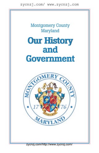
OFFICIAL SYMBOLS OF MONTGOMERY COUNTY, MARYLAND
OFFICIAL COUNTY EMBLEM
The County emblem was adopted in March 1998 by
Administrative Procedure, replacing the coat of arms as
the primary symbol used to identify the government.
The emblem consists of the coat of arms flanked by the
year 1776—the year the county was established—and
encircled by a double ring with the words, “Montgomery
County, Maryland.”
OFFICIAL COAT OF ARMS
Official Coat of Arms of
Montgomery County, Maryland
The coat of arms uses some of the elements of the family 23
arms of General Richard Montgomery for whom the
County was named in 1 776. It was designed and ap-
proved by The College of Arms in London, England and
officially adopted by Bill 38-76 (now Section 1-401 of
the County Code) enacted by the County Council on
October 5, 1976 at the request of the County Executive.
Description of Coat of Arms
The broken spear at the top of the crest is probably an
award to an early member of the Montgomery family.
The spear and the armor encased forearm or cubit arm
are used by those Montgomery families that use the
motto “Gardez Bien” or Guard Well.
The pointed yellow and black flags at the top of the
crest were taken from the Maryland State coat of arms in
order to reflect Montgomery County’s relation with the
State of Maryland.
The gold mural crown is used by many municipalities
and the indented line at its top represents the borders of
a local government.
zycnzj.com/http://www.zycnzj.com/
28. zycnzj.com/ www.zycnzj.com
The helmet and mantling are of a style used in municipal
coats of arms.
The gold fleur-de-lis in two quarters of the shield are
reminders of the French ancestry of the Montgomery
family.
The gold rings with blue gemstones in two quarters of
the shield proclaim royal favor and protection, and are
found in the family coat of arms of General
Montgomery’s family.
The indented line which separates the upper quarters of
the shield from the lower quarters of the shield repre-
sents the borders of a local government.
24 OFFICIAL BIRD AND BLOSSOM OF MONTGOMERY COUNTY
Bill 14-88 made the robin and dogwood the official
county bird and blossom when it was written into law
as Section 1-405 of the Montgomery County Code on
December 14, 1988.
zycnzj.com/http://www.zycnzj.com/
29. zycnzj.com/ www.zycnzj.com
OFFICIAL FLAG OF MONTGOMERY COUNTY
The flag uses some elements of the family
arms of General Richard Montgomery for
whom the County was named. It is based on
the shield of the official coat of arms of
Montgomery County which was designed
and approved by The College of Arms in
London, England and officially adopted by
Bill 38-76(now Section 1-402 of the County
Code) enacted by the County Council on October 5, 1976
at the request of the County Executive.
The gold fleur-de-lis in two quarters of the flag are remind-
ers of the French ancestry of the Montgomery family.
The gold rings with blue gemstones in two quarters of
the flag proclaim royal favor and protection and are
found in the family coat of arms of General
Montgomery’s family.
25
The indented line which separates the upper quarters of
the flag from the lower quarters of the flag represents
the borders of a local government.
The following specifications are used to produce the
County flag: Height to length, 2 to 3. The flag will be
quartered by a crenellated line, separating the top two
quarters from the two bottom quarters, and a straight
vertical line, separating the left two quarters from the
two right quarters. The upper left and lower right
quarters shall consist of a gold fleur-de-lis on a blue
background. The upper right and lower left quarters
shall consist of a gold ring with a blue gem on a red
background. Crenellated line formed of 11 squares, 1/11
of flag length, with center block split in middle with left
side red and right side blue. Rings and fleur-de-lises to
be three times as high as a block in the crenellated line
with width proportional. Rings and fleur-de-lises
centered horizontally on their quarters and spaced
vertically so that upper and lower edge of rings and
fleur-de-lises are equal distance from horizontal outside
edge of quarter and nearest part of crenellated line. Red
and blue should be the same shade as is used in the
United States flag and gold should be same shade as is
used in the Maryland State flag.
zycnzj.com/http://www.zycnzj.com/
30. zycnzj.com/ www.zycnzj.com
COUNTY EXECUTIVES AND COUNCIL MEMBERS, PAST TO PRESENT
1970—1978 James P. Gleason
1978—1986 Charles W. Gilchrist
1986—1990 Sidney Kramer
1990—1994 Neal Potter
1994— Douglas M. Duncan
MONTGOMERY COUNTY COUNCILS
Council/Manager Form of Government
First Council - 1949-1950
J. Douglas Bradshaw P. Garland Ligon
Dorothy S. Himstead Lewis Meriam replaced by
Thomas C. Kelley Harold F. Hammond 4/50
26 Frederic P. Lee Augustus R. Selby
Second Council - 1950-1954
Harold F. Hammond George F. Nesbitt
Kathryn J. Lawlor replaced by Lathrop E. Smith
Louis A. Gravelle 1/53 Grover K. Walker
J. Louis Monarch Stella B. Werner
Third Council - 1954-1958
Wilbur N. Baughman J. Grahame Walker
Charles H. Jamison Stella B. Werner
Robert T. Snure Jerry T. Williams
Grover K. Walker
Fourth Council - 1958-1962
David L. Cahoon Grover K. Walker
Stanley B. Frosh Stella B. Werner
William F. Hickey Jerry T. Williams
B. Houston McCeney
zycnzj.com/http://www.zycnzj.com/
31. zycnzj.com/ www.zycnzj.com
MONTGOMERY COUNTY COUNCILS
Council/Manager Form of Government
Fifth Council - 1962-1966
Kathryn E. Diggs Jerry T. Williams replaced by
John A. Floyd William C. Birely 12/65
Mary A. Hepburn Thomas M. Wilson replaced by
John H. Hiser Cleatus E. Barnett 12/64
Grover K. Walker
Sixth Council - 1966-1970
Cleatus E. Barnett Richmond M. Keeney
Avis Birely Rose C. Kramer
Idamae Garrott David Scull replaced by
William W. Greenhalgh James P. Gleason 3/68
27
Seventh Council - 1970-1974
Idamae Garrott, 1st President Sidney Kramer
Dickran Y. Hovsepian, 2nd President Elizabeth L. Scull
William Sher, 3rd President William H. Willcox replaced by
Neal Potter, 4th President Norman L. Christeller 10/72
Eighth Council - 1974-1978
Dickran Y. Hovsepian, 1st President Esther P. Gelman
Norman L. Christeller, 2nd President Jane Anne Moore
John L. Menke, 3rd President Neal Potter
Elizabeth L. Scull, 4th President William Colman replaced
Mr. Christeller 2/78
Ninth Council - 1978-1982
Neal Potter, 1st President Esther P. Gelman
Scott Fosler, 2nd President Michael L. Gudis
Elizabeth L. Scull, 3rd President Ruth Spector
Neal Potter, 4th President David L. Scull replaced
Rose Crenca Mrs. Scull 6/81
zycnzj.com/http://www.zycnzj.com/
32. zycnzj.com/ www.zycnzj.com
MONTGOMERY COUNTY COUNCILS
Council/Manager Form of Government
Tenth Council - 1982-1986
David L. Scull, 1st President Rose Crenca
Esther P. Gelman, 2nd President Scott Fosler
Michael L. Gudis, 3rd President Neal Potter
William E. Hanna, Jr., 4th President
Eleventh Council - 1986-1990
Rose Crenca, 1st President Bruce Adams
Michael L. Subin, 2nd President Isiah Leggett
Michael L. Gudis, 3rd President Neal Potter
William E. Hanna, Jr.,4th President
28
Twelfth Council - 1990-1994
Isiah Leggett, 1st President Nancy Dacek
Bruce Adams, 2nd President Gail Ewing
Marilyn J. Praisner, 3rd President Betty Ann Krahnke
William E. Hanna, Jr., 4th President Michael L. Subin
Derick Berlage
Thirteenth Council - 1994-1998
Derick Berlage, 1st President William E. Hanna, Jr.
Gail Ewing, 2nd President Betty Ann Krahnke
Marilyn J. Praisner, 3rd President Neal Potter
Isiah Leggett, 4th President Michael L. Subin
Nancy Dacek
Fourteenth Council - 1998-2002
Isiah Leggett, 1st President Betty Ann Krahnke
Phil Andrews Marilyn J. Praisner
Derick Berlage Steven A. Silverman
Nancy Dacek Michael L. Subin
Blair G. Ewing
zycnzj.com/http://www.zycnzj.com/
33. zycnzj.com/ www.zycnzj.com
MONTGOMERY COUNTY DEMOGRAPHICS
Land
Montgomery County is adjacent to the nation’s capital,
Washington, D.C., and is also bordered by the Maryland
counties of Frederick, Carroll, Howard and Prince
George’s, and the State of Virginia.
Rolling land and small hills make up most of Montgom-
ery County’s 497 square miles. There are 15 square
miles of water, including rivers, streams, lakes and
reservoirs, and 28,435 acres of parkland.1 Elevations
range from 52 feet above sea level near the District Line
to 850 feet in the northern portion of the county near
Damascus.
Population
846,000 people have made Montgomery County their
home (January, 1999 estimate). The median age is 36
and slightly more than half of the population is female.2 29
Montgomery County prides itself on its racial diversity
and cultural richness. The county’s population is 73
percent white, 13.4 percent black, and 10.9 percent
Asian/Pacific Islander. Including all races, 8.6 percent of
the population is of Hispanic origin. 2
Housing
Most of the county’s 308,000 homes are single-family
detached dwellings, numbering 160,300. There are 94,400
households in multi-family structures, and 53,300 in
townhouses.3 According to 1997 data from the States Tax
Assessor’s Parcel File, the median single-family sales price
for both new sales and resales is $197,000. The average
apartment rent ranges from $664 for an efficiency to
$1,049 for a three-bedroom apartment.4
The average household size in 1997 was 2.65 persons
with an estimated median household income of
$66,800.2 Families make up 74.9 percent of households
in the county, and of these, 63.6 percent are married-
couple families. Single-parent families account for 9.5
percent of family households, with the remainder
consisting of related family members other than parents
and children.2
zycnzj.com/http://www.zycnzj.com/
34. zycnzj.com/ www.zycnzj.com
Education
Educational attainment of the 559,800 adults in the
county, age 25 and older is as follows; 59.2 percent
have a bachelor’s degree or better, 11.5 percent gradu-
ated high school, with 20.9 percent attending some
college or trade school. The Fall 1998 public school
enrollment was 128,577. 2
Employment
The private sector accounts for 49.7 percent of employ-
ment in the county followed by the government, which
employs 25.8 percent. Non-profit organizations employ
13.2 percent of the workforce and 11.3 percent of
workers are self-employed. 2
Over half of the County workforce works within the
county in mostly professional, executive/managerial or
administrative/clerical positions. Almost 75 percent drive
30 to work alone, while 13.2 percent use public transporta-
tion. Another 9.1 percent of the workforce carpool. 2
Additional Information
For more information about Montgomery County demo-
graphics, visit the Montgomery County Park and Plan-
ning web site, “Montgomery County at a Glance” at the
following address:
http://www.clark.net/pub/mncppc/montgom/factmap/
databook/glance/glance
—————————————————
1
The Maryland-National Capital Park and Planning
Commission, Montgomery County Department of Park
and Planning, Research and Technology Center
2
1997 Census Update Survey
3
July, 1997 (Research Center data)
4
April, 1998 (Office of Landlord-Tenant Affairs —
non-subsidized)
Source:
“Montgomery County at a Glance,” The Maryland-
National Capital Park and Planning Commission,
Montgomery County Department of Park and Planning,
Research and Technology Center. http://www.clark.net/
pub/mncppc/montgom/factmap/databook/glance/glance
zycnzj.com/http://www.zycnzj.com/
35. zycnzj.com/ www.zycnzj.com
Office of Public Information
101 Monroe Street
Rockville, Maryland 20850
240-777-6530
TTY (For Hearing Impaired) 240-777-6505
www. co. mo. md. us
July 1999
zycnzj.com/http://www.zycnzj.com/