1. Transgressive turbitity currents in confined deep-water sedimentary basins demonstrate the potential
to form high quality reservoirs: Tabernas-Sorbas Basin, Southeast Spain.
Principal Investigator (P.I.) – Ben Thomas
1) RATIONALE
Submarine channels are becoming increasingly important and are the focus of ongoing research around the globe,
including in the Gulf of Mexico and offshore Western Africa, in order to grasp a better understanding of their origin,
development and how this affects their potential to form high quality hydrocarbon reservoirs. Over the last 10 years, the
petroleum Industry has become increasingly interested in studying the geometry and structural significance of deep-
water sedimentary basins and submarine channels, as the exploration for hydrocarbon resources turns away from the
dwindling ‘easy to extract’ shallow basin reserves and instead to deep-water facies. In order to analyse a channels
reservoir potential, its properties and architectural development must be identified. Submarine channels form very
complicated reservoirs that are entirely unique from one another.
Confined deep-water sedimentary basins with seismically active basin floors during sedimentation are relatively
poorly understood, as very few are accessible to study in the field. The Tabernas-Sorbas Basin of southern Spain
provides an excellent, sub-aeriel example of a deep-water basin, which was fed by submarine channels, turbididty flows
and fan aprons and displays unequivocal evidence of sediment containment within the basin, whilst also being subject
to ongoing seismic activity. The study area has been extremely well studied since the late 1980’s, resulting in a
comprehensive lithological record. Much of the recent previous work has been carried out by Dr. David Hodgson and
Dr. Peter Haughton. The pair came together to produce a paper in 2004 entitled ‘Impact of syndepositional faulting on
gravity current behavior and deep-water stratigraphy: Tabernas-Sorbas Basin, SE Spain.’ This paper highlights the rarity
of having an active fault system, in the form of the El Cautivo Fault Zone, propagating through to the seafloor during
turbidte deposition and the unique opportunity to study such a feature in the field, in order to quantify the affect active
faulting has on the syndepositional sedimentation of turbidites. The reservoir potential of such basins has not been
extensively studied and no research has been carried out into reservoir potential of the Tabernas Basin.
The aim of this proposed research project is to identify structural and geometrical elements of the turbidites and
submarine channels in the Tabernas Basin that affect reservoir potential and to quantify this potential. Particular
attention will be paid to the Upper Sartenella and Loma de los Banos Formation, as the large, predominately sandstone
beds represent the best potential for a high quality reservoir. In being able to analyse and quantify this potential, an
insight into confined deep-water, fault controlled Mediterranean basins can be achieved.
2) BACKGROUND
The Tabernas Basin is an East-West trending basin of Neogene age, located in the semi-arid desert of southern Spain, to
the Southwest of the small town Tabernas (fig. 1). The study area comprises of excellent, all-be-it eroded outcrops,
showing the different lithologies and structures within the basin including: slumps, fan complexes, channel exposures
and turbidity flows; all of which were identified during preliminary fieldwork carried out in September 2013.
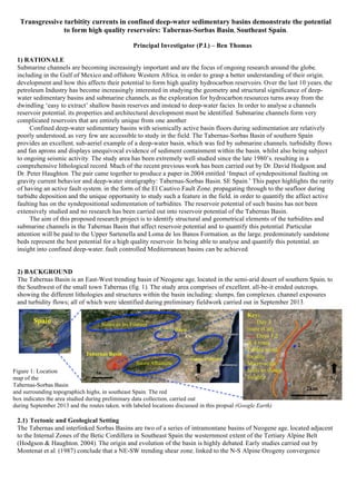
Figure 1: Location
map of the
Tabernas-Sorbas Basin
and surrounding topographich highs, in southeast Spain. The red
box indicates the area studied during preliminary data collection, carried out
during September 2013 and the routes taken, with labeled locations discussed in this propsal (Google Earth)
2.1) Tectonic and Geological Setting
The Tabernas and interlinked Sorbas Basins are two of a series of intramontane basins of Neogene age, located adjacent
to the Internal Zones of the Betic Cordillera in Southeast Spain the westernmost extent of the Tertiary Alpine Belt
(Hodgson & Haughton, 2004). The origin and evolution of the basin is highly debated. Early studies carried out by
Montenat et al. (1987) conclude that a NE-SW trending shear zone, linked to the N-S Alpine Orogeny convergence
Spain
2km
Key:
---- Day 3
route (Car)
---- Days 1,2
& 4 route
Pebble trend
locality
Micro-scale
folds in slump
locality
Sierra Alhamilla
Sierra de los Filabres
Tabernas Basin
Sorbas Basin
10
NN
Sierra Cabrera
1
2
2. caused subsidence in the form of a pull-apart basin (Pickering et al., 2001; Hodgson & Haughton, 2004). Sanz de
Galdeano & Vera (1992) and Stapel et al. (1996) suggest E-W trending dextral strike-slip faults caused subsidence
within the basins (Pickering et al., 2001; Hodgson & Haughton, 2004). The Neogene basins are interpreted as lateral
ramp basins parallel to westerly, deep-seated thrust faults by Poisson et al. (1999). The favoured theory of this report is
the explanation put forward by Hodgson and Haughton (2004) in which they combine theories postulated by Haughton
(2000); Hodgson (2002) and Pickering et al. (2001). The combined structural, stratigraphical and sedimentological
evidence obtained in these studies suggest oblique slip dextral faulting of the seabed during the Late Tortonian and
Early Messinain turbidite sedimentation in the Tabernas Basin was the cause of subsidence (Hodgson & Haughton,
2004). Active faulting on the basin floor caused localized subsidence and ponded accommodation of turbidity flows,
resulting in large, localized accumulations of Loma de los Banos sandstone units (Pickering et al., 2001)
During the Tortonian, the Tabernas basin formed an elongated, deep water E-W trending trough approximately 10
km wide and several tens of kilometers long (Haughton, 2000). Tectonic activity caused the basin to deepen to
approximately 400-600 metres below sea level during the Late Tortonian (Haughton, 2000). Topographic highs of
metamorphic composition surround the basin (fig. 1), with the Sierra de los Filabres to the north, the Sierra Alhamilla to
the south and the Sierra Cabrera to the east. The majority of sediment deposited in the basin is high-grade metamorphic
clasts originating from the Sierra de los Filabres to the north (Hodgson & Haughton, 2004). A smaller proportion of
sediment originated from the southern Sierra Alhamilla basement, which is of lower metamorphic grade. Input from the
latter dissipated through the Tortonian and Early Messinian, but remained critical in the containment of sediment within
the narrow basin (Haughton, 2000; Pickering et al., 2001;Hodgson & Haughton, 2004). The western extent of the basin
(area studied during preliminary fieldwork) consists of a think (>1 km) transgressive-regressive marine succession,
evolving from continental, shallow-water environments, into deep water facies as the basin subsided through the
Tortonian and then to fan-delta deposits (Hodgson & Haughton, 2004).
Sediment was deposited into the basin primarily through the means of gravity-induced flows, including: submarine
channels, turbidity flows, fault-controlled slope aprons and fan deltas (Haughton, 2000). The basin was still tectonically
active during sedimentation, represented in the field by faults seen to displace Tortonian and Early Messinian sediments,
but truncating against the sediments deposited in the Verdelecho Formation of the Late Messinian, showing seismic
activity had ceased by this time. A rapid variation in the style of the stacked turbidite system on the western margin of
the basin was the result of gradient fluctuation, due to alternating periods of faulting and subsequent infill of the basin
(Haughton, 2000). Pulses of coarse sediments were deposited into the basin particularly during the deposition of the
Verdelecho Formation, thought to be due to seismic activity, resulting in mass failure and forming flows termed
seismites (Pickering et al., 2001). The most pronounced example of a seismite is the ‘Gordo Megabed’, a 60 metre
sheet-like bed that covers almost the entirety of the basin; thought to have been deposited due to a catastrophic collapse
along the basin margin to the north during the Late Messinian, as uplift dissapted southwards, but continued in the north
(Kleverlaan, 1987; Pickering et al., 2001; Hodgson & Haughton, 2004).
2.1.1) El Cautivo Fault Zone
The E-W trending El Cautivo Fault Zone, highlighted in figure 2, which was identified during preliminary fieldwork, runs
through the Alfaro Sub-basin to the southwest of Tabernas has been extensively studied. Haughton (2000) and Hodgson
& Haughton (2004) recognize a zone of highly deformed sediments. At its thickest, the fault zone reaches 350 metres
wide, but pinches out to the east and west, resulting in a lens shape. The eastern most extent of the El Cautivo Fault is seen
to displace the units of the Sierra Alhamilla basement by up to 100 m, whereas vertical displacement in the west is as little
as 5 m (Hodgson & Haughton, 2004). This infers a dip-slip aspect to the fault as well as strike slip. The interpretation of
kinematic data collected by Hodgson & Haughton (2004) shows that the gouge fabric within the fault zone trends 0580
,
implying right lateral movement. Faulting resulted in continued deformation of the basin floor during the deposition of
sediments. During periods of tectonic subsidence, the basin slopes increased in gradient, resulting in the bypass of sandy
sediment through high-energy submarine channels. Localized subsidence caused ‘mini-basins’ to form, resulting in pooled
deposits. At times of low seismic activity, the basin filled, resulting in a lowered slope gradient, which led to lateral
deposition of sandy units across the basin floor. The sandy Loma de los Banos Formation was seen to pond against faults
in the field and as Haughton, 2000 and Hodgson & Haughton, 2004) provide evidence for ponding occuring on the
southern side of the El Cautivo Fault, which was not identified during preliminary field work, but will be a main focus of
research in the proposed project. A regional scale anticline formed obliquely the axis of the El Cautivo Fault after the fault
was active, due to the uplift of the Sierra Alhamilla. This has resulted in the bedding planes within the turbidites dipping
SW, south of the fault, which was documented in the field.
2.2) Stratigraphy
The sedimentology of the deep-water basin fill has been studied since 1987 by Kleverlaan (1987, 1989) modifications
have since been made by Haughton (2000), Pickering et al. (2001) and Hodgson & (2002). Three systems were
recognized within the turbidites in the Tabernas area: System 1, a Sandy System; System 2, a Mixed System and System
3. 3, a Solitary Channel. This framework has since been challenged by Hodgson & Haughton (2004). This re-evaluation
has resulted in a new framework being suggested. The sediments, deposited during the Tortonian and Lower Messinian
have been split into four separate units: the Molinos, Sartenella, Loma de los Banos and the Verdelecho Formations
(Hodgson & Haughton, 2004).
2.2.1) Molinos Formation – Early Tortonian
Hodgson (2002) identified that the base of the Molinos Formation consists of red alluvial pebble to boulder
conglomerates deposited in a sub-aerial debris-flow dominated fanglomerate environment, which grade into blue-grey
conglomerates, deposited as a result of an abruptly flooded basin, with the influx of shallow water fauna. The
fanglomerates then pass into bioclastic graded coarse-grained sandstones, deposited as subsidence of the basin
increased, due to extensional tectonics, resulting in a steep-sided basin (Hodgson & Haughton, 2004). The sediment is
thought to have primarily originated from the high metamorphic grade Nevado-Filabride Complex to the northwest of
the basin (fig. 1). The coarse nature of the sediment implies a high-energy environment, with bypassing of sandy
sediments. Bypassing of sand grains of sandy sediments at this time has formed a corner stone to the proposed research,
as the depocentre of the basin must have been further east (assuming easterly flow direction). The P.I. theorizes that this
depocentre is located in the Sorbas Basin, (fig 1) due to its documented interconnectivity of the basins
2.2.2) Sartenella Formation – Late Tortonian
At the base of the Sartenella Formation highly bioturbidated, grey sandy marls were deposited, with rare interbedded
dissipated sandstone layers. This indicates hemipelagic settling onto a well-oxygenated basin floor or slope that is either
being bypassed by sandy sediments or the basin was subject to a low sediment flux at the time (Hodgson & Haughton,
2004). During the Late Tortonian, the Sartenella Formation saw the deposition of medium to coarse-grained sandstones
and pebble to boulder conglomerates, originating from the west of the basin, deposited by high-energy turbidity and
debris flows bypassing the basin within a series of conduits, possibly related to the presence of seabed faults (Haughton,
2000). The channels were then backfilled as the gradient decreased, due to easterly damming of the basin, resulting in
sedimentary structures with an apparent southerwesterly paleoflow direction. The composition of these sediments
suggest that the primary source of sediment was by this time the metacarbonate provenance to the southwest (fig. 1),
which is of a lower metamorphic grade (Hodgson & Haughton, 2004). The late, coarse grained sediments provide
potential for a quality reservoir rock.
2.2.3) Loma de los Banos Formation – Early-Mid Messinian
The Loma de los Banos Formation is comprised of fine sandstones and mudstones, indicating a flat, low energy
environment, as the slope gradient decreased, resulting in lateral deposition of sediment. The featureless sandstone beds
are separated by thick beds of bioturbidated sands. This massive sandstone unit, in conjunction with the sandy
sediments in the upper Sartenella forms the backbone to the proposed research into the reservoir potential of the
Tabernas Basin. Large beds indicate a long period of deposition, with the origin of sediment returning to the schistose
composition of the northern metamorphic basement, but with minor calcarenitic beds and interbedded slump-deformed
marl, suggesting unstable fault scarps on the seabed (Hodgson & Haughton, 2004). Smaller sandstone beds show
sedimentary structures, such as cross bedding, which, due to erratic paleoflow indicators, indicate the reflection of
sediments from topographic highs within the basin and ponded flows, within ‘mini-basins’ created by depressions in the
basin floor, caused by continued seismic activity (Hodgson & Haughton, 2004).
2.2.4) Verdelecho Formation – Late Messinian
The Verdelecho unit wedges out to the south by onlap against a marl slope and extends northwards into a conglomeratic
fringe, indicating continued tectonic uplift to the north. The formation is completely comprised of schistose grains,
originating from the northern Nevado-Filbride Complex (fig. 1). Large extents of sandstone-mudstone couplets that are
set in a matrix of thin-bedded, graded sand sheets. Bioturbidated marls are still present, but not in the quantity of the
lower formation (Hodgson & Haughton, 2004). Continued ponding of both axial and northerly transverse flows on an
ever-decreasing gradient is evident during the Late Messinian, resulting in the blanketing of the now inactive
intrabasinal faults that merged northwards with a coarse-grained apron system (Hodgson & Haughton, 2004).
At the top of the Verdelecho Formation a single, basin-wide unit named the ‘Gordo Megabed’ was rapidly
deposited. This thick (up to 60 metres) monomitic bed, consisting of schist boulders, overlain by graded sandstones and
capped by an unbioturbidated mudstone is thought to have been deposited due to the catastrophic collapse of the still
tectonically active apron system to the north. This debris avalanche was contained within the basin by the Sierra
Alhamilla stratigraphical high in the south (fig. 1) (Hodgson & Haughton, 2004).
4. 2.3) Paeleoflow analysis
Early studies (Kleverlaan, 1987, 1989; Cronin, 1995) concluded that sediment flow within the basin was from east to
west. However, subsequent studies carried out by Haughton (2000); Pickering et al. (2001) and Hodgson & Haughton
(2004) all revise this interpretation to an easterly flow direction. This conclusion was reached through careful analysis
of toolmarks and flute marks across the Tabernas Basin. A re-evaluation of the deposition facies resulted in a
transgressive-regressive system being implied (fig 3).
Figure 3: Block diagrams representing
the transgressive-regressive nature of
the sediments in the western extent of
the basin. A) Shows eastward flowing
incised channels within a steep slope,
resulting in the bypassing of sandy
sediment, and the deposition of the
pebble-boulder conglomerates of the
Molinos Formation. B) Illustrates the
backfilling of channels in sediments of
the Late Sartinella Formation, as the
gradient of the basin floor decreased
and the energy of the flows decreased
as a result of damming topography to the east. C) Westerly sourced turbidity currents infill depressions (mini-basins) within the
basin floor, formed by localized seismic activity. The deposition of these sediments (Loma de los Bonas Formation) eventually
‘healed’ the basin topography. Uplift of the northern margin of basin, in conjunction with the dissipated seismic activity within the
basin resulted in an unstable transverse apron to the north, which resulted in the deposition of turbidites, which then migrated
eastward along the very shallow dipping axial trend and ponded on the basin floor. Continued uplift subsequently resulted in the
mass failure event that deposited the Gordo Megabed (Adapted from Haughton, 2000).
Limited preliminary data collected in the field broadly supports the theories postulated by Hodgson & Haughton (2004)
that sediments during the Tortonian and Messinian originated from the west and flowed eastwards. However, due to the
limited amount of data collected, this conclusion is far from certain. When in the field, the broad indication was that
A B
DC
N
Figure 2: A Map showing the geology of the area studied during preliminary fieldwork,
including the east-west trending El Cautivo Fault Zone. Rose diagrams created from
toolmark data collected by Hodgson & Haughton (2004) in the Loma de los Banos
Formation, indicating flow direction at each location. The toolmark indicators include the
study of grooves, flute marks and ripple trends are included on the map, showing a fairy
disperse data set, but with a definite E/SE trend. The lithological column represents the
newly conceived framework of sedimentary deposition postulated by Hodgson & Haughton
(2004). The column shows the massive sandstone units within the Sartenella and Loma de los
Banos Formations that will be subject to analysis in order to quantify reservoir potential of
the basin. Ponded mudstone caps are identified within the sandstone units of the Loma de los
Banos, which must be carefully mapped (Hodgson & Haughton, 2004)
5. flow direction was southwesterly. It is interpreted by the P.I. that this is due to the main study area being in close
proximity to the El Cautivo Fault and the post depositional anticline formed by the uplift of the Sierra Alhamella, which
resulted in a regional trend of SW dipping strata. Adverse results are explained in past publications (Haughton, 2000;
Pickering et al., 2001 and Hodgson & Haughton, 2004). During the deposition of the Late Sartinella and the Loma de los
Bonas Formations, the confined nature of the basin resulted in the reflection of sediment flows against the structural
highs, meaning that sedimentary structures and the alignment of pebbles ‘false’ directions of flows. This is particularly
true of ripple orientations within the Loma de Los Banos Formation. Alternately these structures may represent flow
direction connected to a single anomaly to the north of Tabernas, identified by Haughton (2000) and discussed in
Hodgson & Haughton (2004), where a small area of flow indicators record a southwesterly paleoflow direction.
Figure 4: 3 stereonets created using data collected during preliminary fieldwork carried out in the study area highlighted in figure 1,
in September 2013. Stereonet A represents the strikes and dips taken of turbidite beds along the two routes shown in figure 1. These
recordings demonstrate a southwesterly trend, with three anomalies to the northeast. This is interpreted to represent post
depositional regional scale folding that occurred obliquely parallel to the El Cautivo Fault, giving a southwesterly dip to the
sediments on the south side and northwesterly dip to the north (Preliminary fieldwork did not extensively cover the basin north of
the fault). B shows the poles of the plunge trends of micro-folds recorded in a large scale slump feature (location 2 on figure 1).
This set of data shows a southwesterly trend to the direction, which represents slumping of the unstable scarp slope of the active El
Cautivo Fault. Stereogram C shows an east-southeast paleoflow trend of pebble orientation data collected at location 1 on figure 1.
This supports the widely accepted belief that sediment flowed in an easterly direction.
This anomaly is interpreted to be due to a sand body within the Sartenella Formation causing a ‘bulge’ in seafloor
topography, which prohibited an easterly flow direction of the Loma de los Bonas sediments (Haughton, 2000). This
resulted in ‘backstepping’ of sediments. This new type of macro-scale sedimentary structure was proposed by Pickering
et al. (2001). The large-scale features (2-5 m high and 30-40 m long) are interpreted to have formed due to damming in
the eastern margin of the basin as the basin floor gradient decreased, as a result of the regression of the basin
depocentre. This caused the channel to be filled and backstepping occured, producing paeleoflow indicators with a
southwesterly trend (Pickering et al., 2001).
Recumbent folds, plunging SW, recorded at location 2 are deemed to be the result of the presence of the active El
Cautivo Fault. Slumping occurred as a result of seismic activity along the fault, which produced an unstable fault scarp
on the seafloor, comprised of poorly-consolidated sediments that subsequently failed in a S-SW direction, due to the
southerly downthrow of the fault (Haughton, 2000; Hodgson & Haughton, 2004).
The general consensus of previous studies into the area is that sediment flow within the basin was west to east.
Collection of paleoflow data across the entire basin must be the first phase of this proposed research, in order to confirm
or reject the hypothesis that flow was to the east. If confirmed, the regressive nature of the Tabernas Basin sediments
indicates that the depocentre of the basin must have migrated westward through time. This is indicated by early
bypassing of sandy sediment during the deposition the Molinos and Early Sartinella Formations (sections 2.2.1 & 2.2.2),
but with thick sandstone units being deposited in the Loma de los Banos Formation. It is therefore conceivable that
sandy sediment from the Early Tortonian was deposited further to the east in the Sorbas Basin. Haughton (2000) and
Pickering et al. (2001) both confirm that the Tabernas and Sorbas Basins were, at times interlinked. If this is proved
correct by this research and Tortonian sandsones in the Sorbas Basin and the Messinian sands in the Tabernas Basin are
interlinked, there is potential for a vast sandstone body to be present spanning the two basins, with the potential to form
a hydrocarbon reservoir.
3) PROJECT AIMS AND OBJECTIVES
As outlined in the previous section, the goal of this project is to build on existing knowledge and confirm the paleoflow
direction of sediments entering the Tabernas Basin to be from west to east. Preliminary data collected in the study area
is inconclusive, as only one set of data was recorded and the general consensus of my field partners was that the flow
A B C
6. indication was southwesterly. However, recent publications from experts in the area have come to the conclusion that
sediment flow was in fact in an easterly direction. These conclusions are built upon the analysis of vast amounts of
paleoflow indicators, collected across the entire basin, over a long period of time. It is the belief of the P.I. that after
extensive research, this conclusion is more valid than the conclusions drawn from data collected during preliminary
fieldwork, as our datasets were collected in a very localized area within the basin fig. 1), over only four days. Previous
research even goes as far to provide reasons for anomalous data sets (section 2.3). In confirming the flow direction to be
easterly, the over-arching aim of the project can be implemented: to quantify the reservoir potential of the sandy units
within the Tabernas and interlinked Sorbas Basins.
H1 Gravity flows depositing sediment into the basin originated from the west and travelled eastward across the
basin.
If H1 is proved correct, further research and data collection can be initiated to test H2 – that the depocentre of the
basin originated in the Sorbas Basin and migrated west as the deposition of sediment regressed. However, if H1 is
proved incorrect, H2 and H3 will no longer be valid lines of research; if the sediment flow was not easterly, then the
depocentre was not originally in the Sorbas Basin. However, testing H4 will still be feasible, as analyzing the
reservoir potential of the sandstone unit in the Tabernas Basin is a stand-alone line of research.
H2 The depocentre of the basin originated in the Sorbas Basin and migrated westward into the Tabernas Basin
through time.
In the case of H2 being correct, data collection for the testing whether the sandstone units in the two basins are
interconnected can commence. If there is no evidence recorded of the depocentre of the basin and therefore the
accumulation of a massive sandstone unit being present in the Sorbas Basin, then they are not interconnected.
H3 The sand rich Loma de los Banos Unit in the Tabernas Basin is connected to sandstone units in the Sorbas
Basin as a result of the migration of the basin depocentre, resulting in a laterally extensive sandstone unit.
On validating H3, evidence will have been collected that confirms a large, laterally extensive sandstone is present
across the two basins and data can be collected to analyse the reservoir potential of this unit. This analysis (H4) can also
be modified to include analysis of sandstone units in the Sorbas Basin. If proven wrong, the interconnectivity of the two
basins is lower than expected, but analysis can still be carried out to test reservoir potential in the Tabernas Basin.
H4 Massive sandstone units in the Loma de los Banos Formation form high quality hydrocarbon reservoirs.
If proven correct, an analogue for high quality reservoir rock in deep-water sedimentary basins within the
Mediterranean will have been identified. This will contribute to knowledge in a subject of ever growing importance for
future hydrocarbon extraction. If proven incorrect, potential lack of sedimentary beds capable of forming good reservoir
rock can be inferred across Mediterranean basins. Either conclusion will result in possible further research into the
controlling factors and the extent to which it can be applied in Mediterranean basins.
4) METHODOLOGY
In order to achieve the goals set out by this proposal, a methodical and structured approach must be adopted. The
hypotheses being tested must be addressed in order, as the rejection of any of the first three hypotheses has
ramifications on the validity of the subsequent tests. All four testable lines of research require a large amount of high
detailed fieldwork and data collection to be carried out. An accurate, highly detailed geological mapping programme
needs to be implemented across the entire Tabernas Basin and if H1 is accepted, across the Sorbas Basin. To maximize
efficiency and avoid unnecessary multiple visits to localities, the initial mapping programme will record data required
for every hypothesis, with sites of particular interest to each being noted. A handheld GPS unit will be utilized, in order
to record every locality and the paths taken to reach them. This will not only allow extremely accurate documentation of
the exact location of particular structures and features relevant to each line of research, but will also highlight the best
access to the outcrop if a second visit to the locality is required. A systematic mapping programme will be implemented
across the basin, in order to document as much of the basin as possible. However, the eroded topography of the basin
will undoubtedly impede access to certain areas. If this is the case, as many outcrops will be visited in the area as
possible, whilst adhering to health and safety constraints, for example outcrops on the edge of a large fall will not be
visited.
4.1) Gravity flows depositing sediment into the basin originated from the west and travelled eastward across the
basin.
Fieldwork: The mapping programme described above will first and foremost document the lithology at every locality
visited whilst collecting data to analyse the direction of sediment flow. This is fundamental for collecting accurate data,
7. as outlined in Hodgson & Haughton (2004) and Haughton (2000), because the separate formations can display localized
anonymous flow directions, due to the constantly changing constraints within the basin and the bedforms associated
with the regressive nature of the deposits up sequence (section 2.3). The following paleoflow toolmark indicators will
be identified and recorded at every outcrop: Groove marks, ripple trends, pebble alignment and flute marks. As many
readings (aim for 20) of each toolmark will be obtained at each location in order to get a representative sample size at
each outcrop. Particular attention in the field will be paid to the area where preliminary data was collected and the area
to the area north of Tabernas, documented in previous studies, as an anomalous site of southwesterly flow, in order to
identify and confirm or challenge the current explanations for these anonamous readings (backstepping, section 2.3).
The strike and dip of bedding planes will be recorded at each locality, in order to be able to identify the affects of the
regional scale, post depositional folding that occurred due to the uplift of the Sierra Alhamilla. Detailed mapping of
micro-scale folding in slump features will be implemented to the south of the El Cautivo Fault Zone, in order to
ascertain the validity of S-SW slump features in the Late Tortonian sediments as a result of an unstable fault scarp on
the basin floor, which resulted in these large-scale features.
Data analysis: The data collected during fieldwork will be analysed using the computer program ‘stereonet 8.’ This
program will allow rose diagrams and stereonets to be created, indicating the flow direction at each locatiaon. The 4
rock formations will be analysed separately, with locality maps being produced for each one. At each locality, the
separate toolmarks will be analysed individually, in order to identify trends within each indicator. For example, ripple
trends in the Loma de los Banos Formation have been identified to have a dispersed direction of flow, due to flow
reflections off structural highs surrounding the contained basin (Hodgson & Haughton, 2004). The input of data will be
carried out during the fieldwork process, which will provide a growing understanding of the trend of sediment flow as
the basin is mapped.
4.2) The depocentre of the basin originated in the Sorbas Basin and migrated westward into the Tabernas Basin
through time.
Fieldwork: A mapping programme will be carried out in the Sorbas Basin, with the same systematic and structured
approach as that of the one carried out in the Tabernas Basin, in order to accurately map the entire basin. Fieldwork will
concentrate on collecting lithological data, in order to produce a stratigraphical column for the interlinked Sorbas Basin.
The main aim of the mapping project will be to locate the sandy sediments that bypassed the Tabernas basin during the
Tortonian as it travelled eastward, due to the steep slope environment that was present in the Tabernas Basin at the time,
which later regressed as the slope gradient decreased, depositing the Loma de los Banos sandstones in a low energy
environment.
Stratigraphical analysis: Stratigaphical records recorded at localities during the mapping of the basin will be used to
create a comprehensive geological map of the basin, which will document the presence of massive sandstone units.
Using the data collected, a stratigraphic column will be produced, which can be compared and contrasted with the
column created in the Tabernas Basin. The geological map will be produced in conjunction with mapping, in order to
build a picture of the stratigraphy as mapping is on going. The creation of the stratigraphical log will commence after
mapping has been completed.
4.3) The sand rich Loma de los Banos and upper Sartenella Formations in the Tabernas Basin are connected to
sandstone units in the Sorbas Basin as a result of the migration of the basin depocentre, resulting in a laterally
extensive sandstone unit.
Fieldwork: The Sorbas and Tabernas Basins are known to have been interlinked at times during deposition of
sediments during the Tortonian and Messinian (Haughton, 2000; Pickering et al., 2001; Hodgson & Haughton, 2004).
During mapping exercises carried out in the Tabernas and Sorbas Basins particular emphasis on documenting the
connectivity will be implemented. When mapping the eastern side of the Tabernas Basin and the western margin of the
Sorbas Basin, contact between the two sandstone units will be sought after and if found, accurately recorded.
Interconnectivity analysis: Once fieldwork, accurately documenting the contact between the sandstone units, is
completed an accurate cross-section of the two basins will be produced, using data collected in the field and that of the
stratigraphical columns, in order to determine the extent of the connectivity.
4.4) Massive sandstone units in the Loma de los Banos and upper Sartenella Formations form high quality
hydrocarbon reservoirs.
Fieldwork: Initial geological mapping of the basins will document outcrops of the sandstone units, which can then be
revisited at this stage, in order to collect rock samples for analysis. The presence of interbedded mudstones within the
units will need to be assessed at this stage, so that the continuity of the sandstones can be quantified. During this stage
8. of mapping, the southern margin of the El Cautivo Fault Zone will be an area of particular interest, due to the presence
of pooled turbidites of the Loma de los Banos Formation identified during preliminary fieldwork. This pooling has
resulted in an increased thickness of the Formation, which may increase the potential of a high quality reservoir rock
being present.
Analysis of samples: In order to quantify the reservoir potential of the sandstone units of the Late Tortonian and Early
Messinian, the porosity and permeability will be quantified. Porosity is the percentage of void space in a rock defined as
the ratio of the volume of voids divided by the total rock volume. Lab work will use the Imbibition Method to identify
the porosity of the sandstone. This involves weighing the rock when dry and then submerging the rock in a wetting fluid
until completely saturated. The pore volume will be calculated by weighing the rock after saturation. The increase in
weight, caused by the fluid of which the density is known, allows the investigator to calculate the pore space, which is
now occupied by the fluid. The permeability of the sandstone will be quantified by pumping a fluid at a known, constant
pressure through the rock sample. Recording the quantity and speed at which the fluid passes through the rock will
determine its permeability.
5) RESEARCH TIMETABLE
The timetable laid out in Table 1 has been set out in order to test the 4 hypotheses in a systematical approach. Analysis
of each hypothesis will be carried out as fieldwork is carried out. As mentioned in section 3, a rejection of any of the
first three hypotheses will have ramifications on the validity of the following research. This will result in a modification
of the research timetable. The preparation of the publication will be initiated and added to, as the separate hypotheses
are accepted or rejected.
The basis of this research project has drawn upon existing knowledge of the Tabernas Basin in conjunction with limited
data collected during preliminary fieldwork. The P.I. believes that the hypotheses set out, if accepted will result in a
significant insight into a field of growing importance and will provide a knowledge base for reservoir potential in
Mediterranean basins as a whole. If accepted, further research into sedimentary structures within the massive sandstone
units, for example the presence of Lateral Accretion Packages within the laterally deposited sands can further assess the
potential of reservoir quality. This is a truly exciting prospect into the discovery of a new form of reservoir.
6) REFERENCES
CRONIN, B. T. 1995. Structurally-controlled deep sea channel courses: examples from the Miocene of southeast Spain and the Alboran Sea,
southwest Mediterranean. Characterisation of Deep Marine Clastic Systems. Geological Society, London, Special Publications, 94, 115-135.
HAUGHTON, P. D. W. 1994. Deposits of deflected and ponded turbidity currents, Sorbas Basin, Southeast Spain. Journal of Sedimentary
Research, A64, 233-246.
HAUGHTON, P. D. W. 2000. Evolving turbidite systems on a deforming basin floor, Tabernas, SE Spain. Sedimentology, 47, 497-518.
HAUGHTON, P. D. W. 2001. Contained turbidites used to track seabed deformation and basin migration, Sorbas Basin, south-east Spain. Basin
research 13, 117-139.
HODGSON, D. M. 2002. Tectono-stratigraphic evolution of a Neogeneoblique extensional orogenic basin, southeast Spain. P.h.D thesis,
University of London.
HODGSON, D. M. & HAUGHTON, P. D. W. 2004. Impact of syndepositional faulting on gravity current behavior and deep-water stratigraphy:
Tabernas-Sorbas Basin, SE Spain. Confined Turbidite Systems, Geological Society, London, Special Publications, 222, 135-158.
KLEVERLAAN, K. 1987. Gordo megabed: a possible seismite in a Tortonian submarine fan, Tabernas Basin, province Almeria, southeast Spain.
Sedimentary Geology, 51, 181-213.
KLEVERLAAN, K. 1989a. Neogene history of the Tabernas basin (SE Spain) and its Tortonian submarine fan development. Geologie en
Mijnbouw, 68, 421-432.
KLEVERLAAN, K. 1989b. Three distinctive feeder-lobe systems within one time slice of the Tortonian Tabernas fan, SE Spain. Sedimentology,
36, 25-45
KLEVERLAAN, K. 1994, Architecture of a sand-rich fan from the Tabernas submarine fan complex, south-east Spain. GCSSEPM Foundation
15th
Annual Research Conference, Submarine Fans and Turbidite Systems, 4-7 December, 209-215
PICKERING, K. T., HODGSON, D. M., PLATZMAN, E., CLARK, J. D. & STEPHENS, C. 2001. A new type of bedform produced by backfilling
processes in a submarine channel, late Miocene, Tabernas-Sorbas Basin, SE Spain. Journal of Sedimentary Research, 71, 692-704
POISSON, A. M., MOREL, J. L., ANDRIEUX, J., COULON, M., ERNLI, R. & GUERNET, C, 1999. The origin and development of Neogene
basins in the SE Betic Cordillera (SE Spain): a case study of the Tabernas-Sorbas and Huercal Overa basins. Journalof Petroleum Geology, 22,
97-114.
SANZ DE GALDEANO, C. & VERA, J. A. 1992. Stratigraphic record and palaeogeographical context of the Neogene basins in the Betic
Cordillera, Spain. Basin Research, 4, 21-36.