Recommended

Recommended
More Related Content
What's hot
What's hot (20)
Similar to OAT: Observation Analysis Tool
Similar to OAT: Observation Analysis Tool (20)
More from Massimiliano Cannata
More from Massimiliano Cannata (7)
Recently uploaded
Recently uploaded (20)
OAT: Observation Analysis Tool
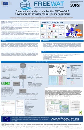
- 1. Observation Analysis Tool This project has received funding from the European Union’s Horizon 2020 research and innovation programme under grant agreement No 642224 www.freewat.eu References: Cannata, M., Antonovic, M., Molinari, M., & Pozzoni, M. (2015). istSOS, a new sensor observation management system: software architecture and a real-case application for flood protection. Geomatics, Natural Hazards and Risk, 6(8), 635-650. Cannata, M., Neumann, J., Cardoso, M., Rossetto, R., Foglia, L. (2016). Observation analysis tool for the FREEWAT GIS environment for water resources management, DOI: 10.7287/peerj.preprints.2127v1 Cannata, M., Neumann, J., Cardoso, M., Rossetto, R., Foglia, L., Borsi, I. (2016). Integration of the MODFLOW Lak7 package in the FREEWAT GIS modelling environment, DOI: 10.7287/peerj.preprints.2207v1 Rossetto, R., Borsi, I., & Foglia, L. (2015). FREEWAT: FREE and open source software tools for WATer resource management. Rendiconti Online Della Società Geologica Italiana, 35, 252–255. http://doi.org/10.3301/ROL.2015.113 The OAT library implements two main classes: the Sensor class that is designated to handle time-series data and metadata and the Method class which is designated to represent a processing method. The library applies the behavioural visitor pattern which allows the separation of an algorithm from the object on which it operates: thanks to this design pattern it is possible to add a new processing capability by simply extending the Method class without the need to modify the Sensor class. OAT.SENSOR Each Sensor object is characterized by a single time-series that is represented by a data section consisting in a PANDAS time-series and a location/metadata section. Every OAT.Sensor object can be stored in a spatialite DB and re-loaded back in OAT.Sensor with its own data and metadata. 2015-06-12 09:40:00, 100, 0.237, OBS1, True 2015-06-12 09:50:00, 100, 0.234, OBS2, True 2015-06-12 10:00:00, 100, 0.237, OBS3, True 2015-06-12 10:10:00, 100, 0.236, OBS4, True 2015-06-12 10:20:00, 100, 0.234, OBS5, True 2015-06-12 10:30:00, 100, 0.237, OBS6, False 2015-06-12 10:40:00, 200, 0.936, OBS7, True 2015-06-12 10:50:00, 200, 0.932, OBS8, True Sensor location and metadata: - Name - Description - Location (lat,lon,elev) - Unit of measure - Observed porperty - Coordinate system - Timezone - Frequency (regular time series) - Weight statistic - Data availability (time interval) Time series of observations - Time - Quality - Values - Obs. Index - Use The results of a process is generally a new OAT.Sensor, so that processes can be concatenated, and the final resulting time- series can be saved in the FREEWAT model database or exported. The currently available OAT.Methods: Resampling, Regularization, data interpolation, Fitting, Filling, data quality assessment, filtering of time-series, Aggregation, exceedance-time, summary statistics, period statistics, Integration, hydrograph separation, evaporation., etc. MODFLOW Various elements of the volumetric water budget for a MODFLOW model can be loaded as sensors and visualised and compared, to other elements of the budget or to other relevant time-series or observations. OAT incorporates the post-processing of MODFLOW model results by creating sensors with appropriate temporal discretisation for the visualisation and further processing of model results as time-series. MODFLOW head and flow observations, listing file volumetric budget components (either as cumulative budgets or rates), and gage file components are currently supported formats. Additionally, OAT can be used to create inputs for the MODFLOW Head Observation package through the direct use of sensor data and metadata. FREEWAT (FREE and open source tools for WATer resource management) is an HORIZON 2020 project financed by the EU Commission. FREEWAT principal result will be an open source and public domain GIS integrated modelling platform for the simulation of water quantity and quality in surface water and groundwater with an integrated water management and planning module. FREEWAT aims at promoting water resource management by simplifying the application of the Water Framework Directive and other EU water related Directives. Specific objectives of the FREEWAT project are: - to coordinate previous EU and national funded research to integrate existing software modules for water management in a single environment into the GIS based FREEWAT; - to support the FREEWAT application in an innovative participatory approach gathering technical staff and relevant stakeholders (in primis policy and decision makers) in designing scenarios for the proper application of water policies. The open source characteristics of the platform allow to consider FREEWAT an initiative "ad includendum", as further research institutions, private developers etc. may contribute to the platform development. FREEWAT CONSORTIUM DURATION: 30 months – started April 1st 2015 – to September 2017 MotivationAbstract Result Time-series are an important aspect of environmental modelling, and are becoming more available through the requirements of the water framework directive as well as more important with the advancement of numerical simulation techniques and increased model complexity. For this reason, within the H2020 FREEWAT project, which aims at facilitating the adoption of modeling for water resource management, the integration of a tool for time-series analysis and processing has been foreseen. As a result the Observation Analysis Tool was developed to enable time-series visualisation, pre-processing of data for model development, and post-processing of model results. Observation Analysis Tool can act as a pre- processor for calibration observations, and will be expanded to incorporate its processing capabilities directly into the calibration process. The tool consists in an expandable Python library and in an interface integrated in the QGIS FREEWAT plug-in which include a large number of modelling capabilities, hydro- chemical data management tools and calibration capacity. The tool has been extensively used and tested in different european institutions, to collect a number of indications to drive the future development. The WFD requirements for increased monitoring activities on water quantity and quality led to an increased collection and availability of data. Raw digital time-series data available through monitoring networks, meteorological services or environmental authorities are always subject to pre-processing before they are used. This Observation Analysis tool (OAT) therefore helps in handling this kind of data, which in spatio- temporal simulation models are inputs for model conceptualization and implementation. Time-series data can be climate data such as rainfall and temperature, boundary conditions such as surface water stages or discharge measurements, or pumping and irrigation rates among others. OAT (Observations Analysis Tool ) is a tool thought to bring time series data processing capabilities in FREEWAT in order to support advanced model calibration. It is designed to facilitate: •the import of time series data into FREEWAT, •the analysis of measures including visualization and elaboration, •the management of data, •the usage of these data in FREEWAT models calibration.