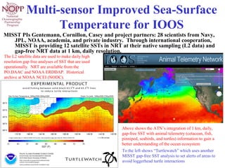
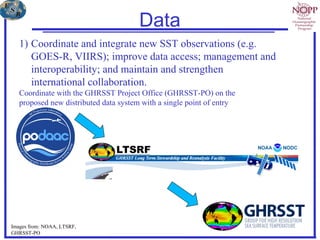
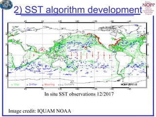
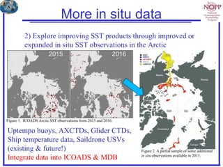
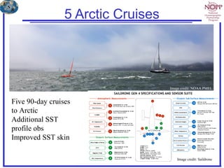
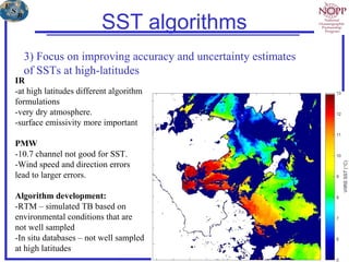
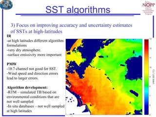
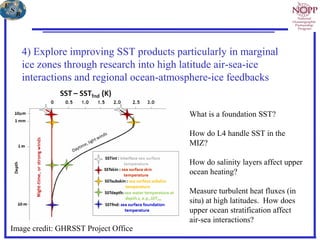
1. Multi-sensor Improved Sea-Surface
Temperature for IOOS
MISST PIs Gentemann, Cornillon, Casey and project partners: 28 scientists from Navy,
JPL, NOAA, academia, and private industry. Through international cooperation,
MISST is providing 12 satellite SSTs in NRT at their native sampling (L2 data) and
gap-free NRT data at 1 km, daily resolution.
The L2 satellite data are used to make daily high
resolution gap free analyses of SST that are used
operationally. NRT are available from the
PO.DAAC and NOAA ERDDAP. Historical
archive at NOAA NCEI (NODC).
Above shows the ATN’s integration of 1 km, daily,
gap-free SST with animal telemetry (cetacean, fish,
pinniped, seabirds, and turtles) information to gain a
better understanding of the ocean ecosystem
To the left shows “Turtlewatch” which uses another
MISST gap-free SST analysis to set alerts of areas to
avoid loggerhead turtle interactions
3. Multi-sensor Improved Sea Surface Temperature: continuing the
GHRSST partnership & improving Arctic data
PI: Chelle L. Gentemann, Earth and Space Research
Co-I: Peter Minnett, University of Miami
Co-I: Michael Steele, University of Washington
16 partners in :
Industry: Richard Jenkins (Saildrone), Jean-Francois Cayula
(Vencore)
Academia: Sandra Castro (U.Colorado), Peter Cornillon (U.Rhode
Island), Dale Robinson (UC Santa Cruz), Andy Harris (U. Maryland)
Governmental: NASA: Edward M. Armstrong (JPL/Caltech), Toshio
Mike Chin (JPL/Caltech), Jorge Vazquez (JPL/Caltech), Vardis Tsontos
(JPL/Caltech)
Governmental: NOAA: Kenneth Casey (NCEI), Edward Cokelet
(NOAA/PMEL), Eileen Maturi (NOAA/NESDIS/STAR), Gary Wick
(NOAA/OAR/ESRL), Cara Wilson (NOAA/NMFS/SWFSC)
Governmental: ONR: Charlie Barron (NRL/SSC)
New Project 2018 - 2023
4. Project objectives
1) Coordinate and integrate new SST observations (e.g.
GOES-R, VIIRS); improve data access; management and
interoperability; and maintain and strengthen
international collaboration.
2) Explore improving SST products through improved or
expanded in situ SST observations in the Arctic
3) Focus on improving accuracy and uncertainty estimates
of SSTs at high-latitudes
4) Explore improving SST products particularly in marginal
ice zones through research into high latitude air-sea-ice
interactions and regional ocean-atmosphere-ice feedbacks
5. Data
1) Coordinate and integrate new SST observations (e.g.
GOES-R, VIIRS); improve data access; management and
interoperability; and maintain and strengthen
international collaboration.
Coordinate with the GHRSST Project Office (GHRSST-PO) on the
proposed new distributed data system with a single point of entry
Images from: NOAA, LTSRF,
GHRSST-PO
6. 2) SST algorithm development
https://icdc.cen.uni-
hamburg.de/fileadmin/user_upload/
icdc_Dokumente/MODIS/kilpatric
ketal_AdecadeofSeaSurfaceTemper
aturefromMODIS_RSE_165_27-
41_2015.pdf
Image credit: IQUAM NOAA
In situ SST observations 12/2017
7. More in situ data
2) Explore improving SST products through improved or
expanded in situ SST observations in the Arctic
Uptempo buoys, AXCTDs, Glider CTDs,
Ship temperature data, Saildrone USVs
(existing & future!)
Integrate data into ICOADS & MDB
9. SST algorithms
3) Focus on improving accuracy and uncertainty estimates
of SSTs at high-latitudes
IR
-at high latitudes different algorithm
formulations
-very dry atmosphere.
-surface emissivity more important
PMW
-10.7 channel not good for SST.
-Wind speed and direction errors
lead to larger errors.
Algorithm development:
-RTM – simulated TB based on
environmental conditions that are
not well sampled
-In situ databases – not well sampled
at high latitudes
10. SST algorithms
3) Focus on improving accuracy and uncertainty estimates
of SSTs at high-latitudes
IR
-at high latitudes different algorithm
formulations
-very dry atmosphere.
-surface emissivity more important
PMW
-10.7 channel not good for SST.
-Wind speed and direction errors
lead to larger errors.
Algorithm development:
-RTM – simulated TB based on
environmental conditions that are
not well sampled
-In situ databases – not well sampled
at high latitudes
11. 4) Explore improving SST products particularly in marginal
ice zones through research into high latitude air-sea-ice
interactions and regional ocean-atmosphere-ice feedbacks
Image credit: GHRSST Project Office
What is a foundation SST?
How do L4 handle SST in the
MIZ?
How do salinity layers affect upper
ocean heating?
Measure turbulent heat fluxes (in
situ) at high latitudes. How does
upper ocean stratification affect
air-sea interactions?