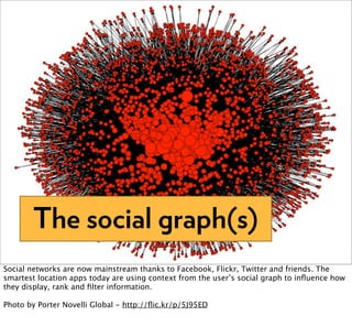
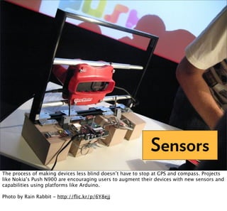
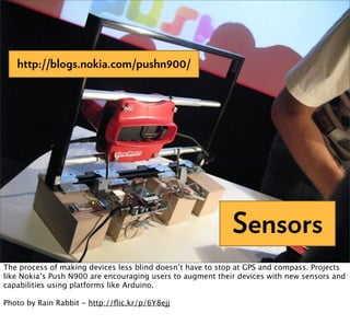
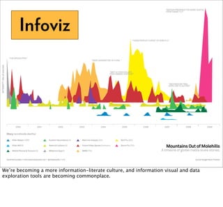
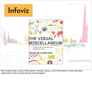
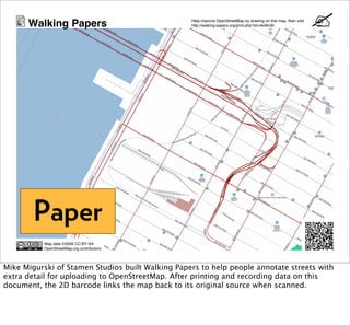
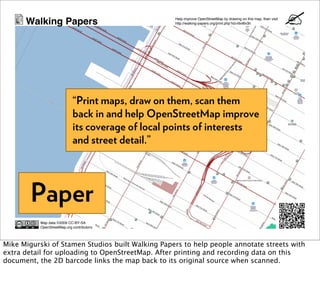
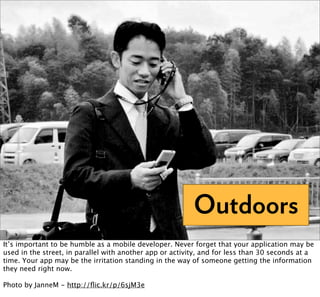
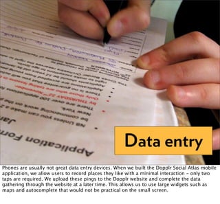
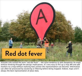
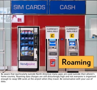
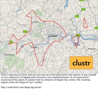
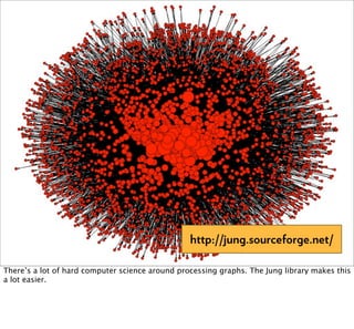
Mobile Social Location
                                                    Matt Biddulph, Nokia
                                                     Web 2.0 NYC 2009


icons by http://www.famfamfam.com/lab/icons/silk/
Where We Are Now
Street data
We’ve always had static information in public space that’s designed to be interpreted by users
of that space.

photo: http://flic.kr/p/9CKCw
Mobile Content
In the early days of small mobile devices, apps like Vindigo delivered static content by
syncing to an internet-connected computer. The device is blind - it doesn’t know where its
user is or anything about the environment in which it’s used. It has to be told.

The interfaces on these apps are usually very simple and fast, partly due to the low power
devices, but also because they’re designed to be used in a hurry in public space.
Ratings and Reviews
There have always been websites that let users rate and review places - sites like TripAdvisor
have a huge amount of data collected over years.

And yes, Beijing has an official star-rating committee for toilets.
Maps


Traditional symbolic representations of space ...
Maps


... are now widely available online to build into apps
Sat Nav
Turn-by-turn navigation - usually provided by Navteq, Teleatlas and Google - is the hot
topic in online maps right now.

Photo by Perfesser - http://flic.kr/p/4cbfmj
Street screens


Static street content is slowly becoming dynamic ...
Street screens


... but the interactions, when they exist, are not always smooth experiences.

http://anti-mega.com/antimega/2009/09/30/screens-in-context
Snap To Grid


A simple lat/long coordinate is not enough for most people-oriented apps. We need a way to
turn a GPS read into a human-meaningful place such as a cafe, office or home. APIs and
datasets to do this are starting to appear.

Photo by paalia - http://flic.kr/p/6sAzuf
Snap To Grid


         “electronic acquisition pays no attention to geography”
                        —Chris Heathcote, 2004


A simple lat/long coordinate is not enough for most people-oriented apps. We need a way to
turn a GPS read into a human-meaningful place such as a cafe, office or home. APIs and
datasets to do this are starting to appear.

Photo by paalia - http://flic.kr/p/6sAzuf
The Checkin
If we can translate a user’s location into something meaningful, we can add layers of
information on top.
The Checkin
Lots of interesting apps are based around the idea of “checking in” at a location rather than
simply recording GPS tracklogs.
Location brokers
As location information becomes a core part of many apps, we’re seeing services such as
Yahoo Fire Eagle, Google Latitude and Twitter provide a way to selectively share your location
with other applications. This can provide a quick bootstrap for a new app, and separate the
problem of location acquisition (via many possible devices and channels) from application
concerns.
Journaling


Social location isn’t just about what’s happening right now. There’s a lot of value in building
a personal dataset of meaningful location history.

Photo by littlevanities - http://flic.kr/p/6Kt6Rt
Intention sharing
At Dopplr we’ve tried to delight people with historical data, showing them the patterns in
their travel history.

Intrinsic to Dopplr is another important trait, the sharing of future location plans.
Games
Games like Foursquare and Noticings build on location technology and place APIs to create a
playful layer over cities.
“Players are awarded points for things like
         spotting the first thing in a neighbourhood,
         or noticing something every day for a week.”


                                                                Games
Games like Foursquare and Noticings build on location technology and place APIs to create a
playful layer over cities.
Where We Are Going
Compass


We’ve had GPS for a long time and it’s been in affordable devices for a couple of years.
Manufacturers appear to have only recently recognised that an electronic compass adds a lot
to the picture that the “blind” phone sees by GPS...
Augmented Reality
... in particular, knowing which way a user is oriented allows more effective overlaying of
information onto their local context.

Photo by Marc Wathieu - http://flic.kr/p/5ZwuhQ
Realtime
There’s growing interest in apps that can communicate in both directions between client and
server - the return of Push. Protocols like XMPP and Pubsubhubbub are providing a way for
an app to push information to users in realtime based on their preferences or their current
context.

Photo by Hugo! - http://flic.kr/p/2yr85
The social graph(s)
Social networks are now mainstream thanks to Facebook, Flickr, Twitter and friends. The
smartest location apps today are using context from the user’s social graph to influence how
they display, rank and filter information.

Photo by Porter Novelli Global - http://flic.kr/p/5J95ED
Sensors
The process of making devices less blind doesn’t have to stop at GPS and compass. Projects
like Nokia’s Push N900 are encouraging users to augment their devices with new sensors and
capabilities using platforms like Arduino.

Photo by Rain Rabbit - http://flic.kr/p/6Y8ejj
http://blogs.nokia.com/pushn900/


                                                            Sensors
The process of making devices less blind doesn’t have to stop at GPS and compass. Projects
like Nokia’s Push N900 are encouraging users to augment their devices with new sensors and
capabilities using platforms like Arduino.

Photo by Rain Rabbit - http://flic.kr/p/6Y8ejj
Infoviz


We’re becoming a more information-literate culture, and information visual and data
exploration tools are becoming commonplace.
Infoviz


We’re becoming a more information-literate culture, and information visual and data
exploration tools are becoming commonplace.
Concordance
A major problem when you work with disparate large datasets is mapping information from
dataset to dataset. A concordance between two datasets (e.g. mapping from Yahoo’s WOE
place IDs to Geonames IDs) allows us to combine data in interesting new ways.

Flickr is implicitly building sets of concordances through their machine tag integrations. A
photo of a restaurant in San Francisco may have tags indicating its IDs both in Foursquare
and in Dopplr. Hopefully they’ll open up this concordance data through their API eventually.
Paper
Paper is still a big enabler in recording and communicating data. Aaron Straup Cope is
building all sorts of interesting bridges between the internet and print. http://
www.aaronland.info/papernet/
The Internet has rightly been called an
         "architectures of participation".
         Paper, though, remains the most
         succesful and robust architecture of
         shared histories to date.
                            —Aaron Straup Cope


                                                                    Paper
Paper is still a big enabler in recording and communicating data. Aaron Straup Cope is
building all sorts of interesting bridges between the internet and print. http://
www.aaronland.info/papernet/
Walking Papers                              Help improve OpenStreetMap by drawing on this map, then visit
                                                  http://walking-papers.org/print.php?id=r6vt6v3h


        Paper
           Map data ©2009 CC-BY-SA
           OpenStreetMap.org contributors


Mike Migurski of Stamen Studios built Walking Papers to help people annotate streets with
extra detail for uploading to OpenStreetMap. After printing and recording data on this
document, the 2D barcode links the map back to its original source when scanned.
Walking Papers                               Help improve OpenStreetMap by drawing on this map, then visit
                                                   http://walking-papers.org/print.php?id=r6vt6v3h


                             “Print maps, draw on them, scan them
                             back in and help OpenStreetMap improve
                             its coverage of local points of interests
                             and street detail.”


        Paper
           Map data ©2009 CC-BY-SA
           OpenStreetMap.org contributors


Mike Migurski of Stamen Studios built Walking Papers to help people annotate streets with
extra detail for uploading to OpenStreetMap. After printing and recording data on this
document, the 2D barcode links the map back to its original source when scanned.
Careful Where You Go
Outdoors
It’s important to be humble as a mobile developer. Never forget that your application may be
used in the street, in parallel with another app or activity, and for less than 30 seconds at a
time. Your app may be the irritation standing in the way of someone getting the information
they need right now.

Photo by JanneM - http://flic.kr/p/6sjM3e
Data entry
Phones are usually not great data entry devices. When we built the Dopplr Social Atlas mobile
application, we allow users to record places they like with a minimal interaction - only two
taps are required. We upload these pings to the Dopplr website and complete the data
gathering through the website at a later time. This allows us to use large widgets such as
maps and autocomplete that would not be practical on the small screen.
Red dot fever
Schuyler Erle coined the term “red dot fever” - the naive tendency to plot datapoints on maps
without thinking through the design implications. It’s very easy to fire up a map API and add
markers to a map without realising how unclear the representation can become. Information
can often be processed by clustering or filtering before being mapped. Indeed, maps aren’t
always the best representation of place data.
Roaming
Be aware that (particularly outside North America) many apps are used outside their phone’s
home country. Roaming data charges are still disturbingly high and not everyone is organised
enough to swap SIM cards at the airport when they travel. Be conservative with your use of
data.
“35 ways to find
                                    your location”


There’s a great set of slides from Chris Heathcote reminding us that GPS isn’t the only way to
find your location. There are many other technical and cultural approaches.

http://conferences.oreillynet.com/cs/et2004/view/e_sess/4657
“35 ways to find
                                    your location”
                                                Chris Heathcote, Etech 2004


There’s a great set of slides from Chris Heathcote reminding us that GPS isn’t the only way to
find your location. There are many other technical and cultural approaches.

http://conferences.oreillynet.com/cs/et2004/view/e_sess/4657
What Will Get Us There
http://www.geonames.org/

Open datasets such as GeoNames can be the backbone of a city-based app. It has millions of
lat/long points for cities all over the world. We couldn’t have built Dopplr without Geonames.
OpenStreetMap
The collaboratively-produced OpenStreetMap project is now an amazingly rich source of
street levels maps.
Maps From Scratch


http://www.mapsfromscratch.com/ provides Amazon EC2 images that boot into a
precompiled environment designed for processing geo data. Hard to compile libraries are
preconfigured and immediately available.
clustr
Flickr’s opensource clustr tool can turn any set of lat/long points into regions. It was created
to turn collections of tagged photo locations into neighbourhoods. As an experiment I
clustered all the places in London that my network on Dopplr has visited. The resulting
regions show the shape of “our” London.

http://code.flickr.com/blog/tag/clustr/
http://jung.sourceforge.net/

There’s a lot of hard computer science around processing graphs. The Jung library makes this
a lot easier.
http://lucene.apache.org/mahout/

There’s also a lot of hard computer science around machine learning. Mahout is building
scalable Hadoop-based libraries for recommendation, clustering, collaborative filter and
auto-classification.
“scalable, Apache licensed machine learning libraries”


                                         http://lucene.apache.org/mahout/

There’s also a lot of hard computer science around machine learning. Mahout is building
scalable Hadoop-based libraries for recommendation, clustering, collaborative filter and
auto-classification.
Thank You
 Matt Biddulph, Nokia
  Web 2.0 NYC 2009

Mobile Social Location (Web 2.0 NYC edition)

  • 1.
    Mobile Social Location Matt Biddulph, Nokia Web 2.0 NYC 2009 icons by http://www.famfamfam.com/lab/icons/silk/
  • 2.
  • 3.
    Street data We’ve alwayshad static information in public space that’s designed to be interpreted by users of that space. photo: http://flic.kr/p/9CKCw
  • 4.
    Mobile Content In theearly days of small mobile devices, apps like Vindigo delivered static content by syncing to an internet-connected computer. The device is blind - it doesn’t know where its user is or anything about the environment in which it’s used. It has to be told. The interfaces on these apps are usually very simple and fast, partly due to the low power devices, but also because they’re designed to be used in a hurry in public space.
  • 5.
    Ratings and Reviews Therehave always been websites that let users rate and review places - sites like TripAdvisor have a huge amount of data collected over years. And yes, Beijing has an official star-rating committee for toilets.
  • 6.
  • 7.
    Maps ... are nowwidely available online to build into apps
  • 8.
    Sat Nav Turn-by-turn navigation- usually provided by Navteq, Teleatlas and Google - is the hot topic in online maps right now. Photo by Perfesser - http://flic.kr/p/4cbfmj
  • 9.
    Street screens Static streetcontent is slowly becoming dynamic ...
  • 10.
    Street screens ... butthe interactions, when they exist, are not always smooth experiences. http://anti-mega.com/antimega/2009/09/30/screens-in-context
  • 11.
    Snap To Grid Asimple lat/long coordinate is not enough for most people-oriented apps. We need a way to turn a GPS read into a human-meaningful place such as a cafe, office or home. APIs and datasets to do this are starting to appear. Photo by paalia - http://flic.kr/p/6sAzuf
  • 12.
    Snap To Grid “electronic acquisition pays no attention to geography” —Chris Heathcote, 2004 A simple lat/long coordinate is not enough for most people-oriented apps. We need a way to turn a GPS read into a human-meaningful place such as a cafe, office or home. APIs and datasets to do this are starting to appear. Photo by paalia - http://flic.kr/p/6sAzuf
  • 13.
    The Checkin If wecan translate a user’s location into something meaningful, we can add layers of information on top.
  • 14.
    The Checkin Lots ofinteresting apps are based around the idea of “checking in” at a location rather than simply recording GPS tracklogs.
  • 15.
    Location brokers As locationinformation becomes a core part of many apps, we’re seeing services such as Yahoo Fire Eagle, Google Latitude and Twitter provide a way to selectively share your location with other applications. This can provide a quick bootstrap for a new app, and separate the problem of location acquisition (via many possible devices and channels) from application concerns.
  • 16.
    Journaling Social location isn’tjust about what’s happening right now. There’s a lot of value in building a personal dataset of meaningful location history. Photo by littlevanities - http://flic.kr/p/6Kt6Rt
  • 17.
    Intention sharing At Dopplrwe’ve tried to delight people with historical data, showing them the patterns in their travel history. Intrinsic to Dopplr is another important trait, the sharing of future location plans.
  • 18.
    Games Games like Foursquareand Noticings build on location technology and place APIs to create a playful layer over cities.
  • 19.
    “Players are awardedpoints for things like spotting the first thing in a neighbourhood, or noticing something every day for a week.” Games Games like Foursquare and Noticings build on location technology and place APIs to create a playful layer over cities.
  • 20.
  • 21.
    Compass We’ve had GPSfor a long time and it’s been in affordable devices for a couple of years. Manufacturers appear to have only recently recognised that an electronic compass adds a lot to the picture that the “blind” phone sees by GPS...
  • 22.
    Augmented Reality ... inparticular, knowing which way a user is oriented allows more effective overlaying of information onto their local context. Photo by Marc Wathieu - http://flic.kr/p/5ZwuhQ
  • 23.
    Realtime There’s growing interestin apps that can communicate in both directions between client and server - the return of Push. Protocols like XMPP and Pubsubhubbub are providing a way for an app to push information to users in realtime based on their preferences or their current context. Photo by Hugo! - http://flic.kr/p/2yr85
  • 24.
    The social graph(s) Socialnetworks are now mainstream thanks to Facebook, Flickr, Twitter and friends. The smartest location apps today are using context from the user’s social graph to influence how they display, rank and filter information. Photo by Porter Novelli Global - http://flic.kr/p/5J95ED
  • 25.
    Sensors The process ofmaking devices less blind doesn’t have to stop at GPS and compass. Projects like Nokia’s Push N900 are encouraging users to augment their devices with new sensors and capabilities using platforms like Arduino. Photo by Rain Rabbit - http://flic.kr/p/6Y8ejj
  • 26.
    http://blogs.nokia.com/pushn900/ Sensors The process of making devices less blind doesn’t have to stop at GPS and compass. Projects like Nokia’s Push N900 are encouraging users to augment their devices with new sensors and capabilities using platforms like Arduino. Photo by Rain Rabbit - http://flic.kr/p/6Y8ejj
  • 27.
    Infoviz We’re becoming amore information-literate culture, and information visual and data exploration tools are becoming commonplace.
  • 28.
    Infoviz We’re becoming amore information-literate culture, and information visual and data exploration tools are becoming commonplace.
  • 29.
    Concordance A major problemwhen you work with disparate large datasets is mapping information from dataset to dataset. A concordance between two datasets (e.g. mapping from Yahoo’s WOE place IDs to Geonames IDs) allows us to combine data in interesting new ways. Flickr is implicitly building sets of concordances through their machine tag integrations. A photo of a restaurant in San Francisco may have tags indicating its IDs both in Foursquare and in Dopplr. Hopefully they’ll open up this concordance data through their API eventually.
  • 30.
    Concordance A major problemwhen you work with disparate large datasets is mapping information from dataset to dataset. A concordance between two datasets (e.g. mapping from Yahoo’s WOE place IDs to Geonames IDs) allows us to combine data in interesting new ways. Flickr is implicitly building sets of concordances through their machine tag integrations. A photo of a restaurant in San Francisco may have tags indicating its IDs both in Foursquare and in Dopplr. Hopefully they’ll open up this concordance data through their API eventually.
  • 31.
    Paper Paper is stilla big enabler in recording and communicating data. Aaron Straup Cope is building all sorts of interesting bridges between the internet and print. http:// www.aaronland.info/papernet/
  • 32.
    The Internet hasrightly been called an "architectures of participation". Paper, though, remains the most succesful and robust architecture of shared histories to date. —Aaron Straup Cope Paper Paper is still a big enabler in recording and communicating data. Aaron Straup Cope is building all sorts of interesting bridges between the internet and print. http:// www.aaronland.info/papernet/
  • 33.
    Walking Papers Help improve OpenStreetMap by drawing on this map, then visit http://walking-papers.org/print.php?id=r6vt6v3h Paper Map data ©2009 CC-BY-SA OpenStreetMap.org contributors Mike Migurski of Stamen Studios built Walking Papers to help people annotate streets with extra detail for uploading to OpenStreetMap. After printing and recording data on this document, the 2D barcode links the map back to its original source when scanned.
  • 34.
    Walking Papers Help improve OpenStreetMap by drawing on this map, then visit http://walking-papers.org/print.php?id=r6vt6v3h “Print maps, draw on them, scan them back in and help OpenStreetMap improve its coverage of local points of interests and street detail.” Paper Map data ©2009 CC-BY-SA OpenStreetMap.org contributors Mike Migurski of Stamen Studios built Walking Papers to help people annotate streets with extra detail for uploading to OpenStreetMap. After printing and recording data on this document, the 2D barcode links the map back to its original source when scanned.
  • 35.
  • 36.
    Outdoors It’s important tobe humble as a mobile developer. Never forget that your application may be used in the street, in parallel with another app or activity, and for less than 30 seconds at a time. Your app may be the irritation standing in the way of someone getting the information they need right now. Photo by JanneM - http://flic.kr/p/6sjM3e
  • 37.
    Data entry Phones areusually not great data entry devices. When we built the Dopplr Social Atlas mobile application, we allow users to record places they like with a minimal interaction - only two taps are required. We upload these pings to the Dopplr website and complete the data gathering through the website at a later time. This allows us to use large widgets such as maps and autocomplete that would not be practical on the small screen.
  • 38.
    Red dot fever SchuylerErle coined the term “red dot fever” - the naive tendency to plot datapoints on maps without thinking through the design implications. It’s very easy to fire up a map API and add markers to a map without realising how unclear the representation can become. Information can often be processed by clustering or filtering before being mapped. Indeed, maps aren’t always the best representation of place data.
  • 39.
    Roaming Be aware that(particularly outside North America) many apps are used outside their phone’s home country. Roaming data charges are still disturbingly high and not everyone is organised enough to swap SIM cards at the airport when they travel. Be conservative with your use of data.
  • 40.
    “35 ways tofind your location” There’s a great set of slides from Chris Heathcote reminding us that GPS isn’t the only way to find your location. There are many other technical and cultural approaches. http://conferences.oreillynet.com/cs/et2004/view/e_sess/4657
  • 41.
    “35 ways tofind your location” Chris Heathcote, Etech 2004 There’s a great set of slides from Chris Heathcote reminding us that GPS isn’t the only way to find your location. There are many other technical and cultural approaches. http://conferences.oreillynet.com/cs/et2004/view/e_sess/4657
  • 42.
    What Will GetUs There
  • 43.
    http://www.geonames.org/ Open datasets suchas GeoNames can be the backbone of a city-based app. It has millions of lat/long points for cities all over the world. We couldn’t have built Dopplr without Geonames.
  • 44.
    OpenStreetMap The collaboratively-produced OpenStreetMapproject is now an amazingly rich source of street levels maps.
  • 45.
    Maps From Scratch http://www.mapsfromscratch.com/provides Amazon EC2 images that boot into a precompiled environment designed for processing geo data. Hard to compile libraries are preconfigured and immediately available.
  • 46.
    clustr Flickr’s opensource clustrtool can turn any set of lat/long points into regions. It was created to turn collections of tagged photo locations into neighbourhoods. As an experiment I clustered all the places in London that my network on Dopplr has visited. The resulting regions show the shape of “our” London. http://code.flickr.com/blog/tag/clustr/
  • 47.
    http://jung.sourceforge.net/ There’s a lotof hard computer science around processing graphs. The Jung library makes this a lot easier.
  • 48.
    http://lucene.apache.org/mahout/ There’s also alot of hard computer science around machine learning. Mahout is building scalable Hadoop-based libraries for recommendation, clustering, collaborative filter and auto-classification.
  • 49.
    “scalable, Apache licensedmachine learning libraries” http://lucene.apache.org/mahout/ There’s also a lot of hard computer science around machine learning. Mahout is building scalable Hadoop-based libraries for recommendation, clustering, collaborative filter and auto-classification.
  • 50.
    Thank You MattBiddulph, Nokia Web 2.0 NYC 2009