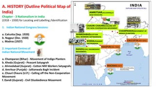
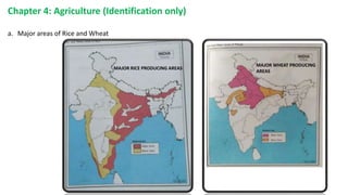
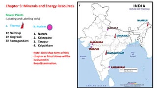
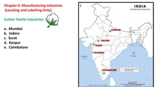
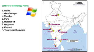
Class:10
GEOGRAPHY (Outline Political Map of India)
Chapter 1: Resources and Development (Identification only)
a. Major soil Types
A. HISTORY (Outline Political Map of
India)
Chapter - 3 Nationalism in India
(1918 – 1930) for Locating and Labelling /Identification
1. Indian National Congress Sessions:
a. Calcutta (Sep. 1920)
b. Nagpur (Dec. 1920)
c. Madras (1927)
2. Important Centres of
Indian National Movement
a. Champaran (Bihar) - Movement of Indigo Planters
b. Kheda (Gujarat) - Peasant Satyagrah
c. Ahmedabad (Gujarat) - Cotton Mill Workers Satyagraha
d. Amritsar (Punjab) - Jallianwala Bagh Incident
e. Chauri Chaura (U.P.) - Calling off the Non-Cooperation
Movement
f. Dandi (Gujarat) - Civil Disobedience Movement
Chapter 3: Water Resources
(Locating and Labelling)
Dams:
Note: Only map items of this chapter as listed above will be
evaluated in Board
Examination.
DAMS RIVERS STATE
SALAL PROJECT CHENAB JAMMU &KASHMIR
BHAKRA NANGAL SATLUJ HIMACHAL
PRADESH
TEHRI GANGA UTTARAKHAND
RANA PRATAP SAGAR CHAMBAL RAJASTHAN
SARDAR SAROVAR NARMADA GUJARAT
HIRAKUD MAHANADI ORISSA
NAGARJUNA SAGAR KRISHNA ANDHRA PRADESH
TUNGABADRA TUNGABADRA KARNATAKA
Chapter 4: Agriculture (Identification only)
a. Major areas of Rice and Wheat
MAJOR RICE PRODUCING AREAS
MAJOR WHEAT PRODUCING
AREAS
b. Largest / Major producer states of :
Sugarcane
Tea
 Coffee
 Rubber
 Cotton
 Jute
Chapter 5: Minerals and Energy Resources
Power Plants
(Locating and Labelling only)
a. Thermal
1 Namrup
2 Singrauli
3 Ramagundam
b. Nuclear
1. Narora
2. Kakrapara
3. Tarapur
4. Kalpakkam
Note: Only Map Items of this
chapter as listed above will be
evaluated in
BoardExamination.
Chapter 6: Manufacturing Industries
(Locating and Labelling Only)
Cotton Textile Industries:
a. Mumbai
b. Indore
c. Surat
d. Kanpur
e. Coimbatore
Iron and Steel Plants:
a. Durgapur
b. Bokaro
c. Jamshedpur
d. Bhilai
e. Vijaynagar
f. Salem
Software Technology Parks:
a. Noida
b. Gandhinagar
c. Mumbai
d. Pune
e. Hyderabad
f. Bengaluru
g. Chennai
h. Thiruvananthapuram
Chapter 7: Lifelines of National Economy
(Locating and Labelling)
Major Ports:
a. Kandla
b. Mumbai
c. Marmagao
d. New Mangalore
e. Kochi
f. Tuticorin
g. Chennai
h. Vishakhapatnam
i. Paradip
j. Haldia
International Airports:
a. Amritsar (Raja Sansi)
b. Delhi (Indira Gandhi International)
c. Mumbai (Chhatrapati Shivaji)
d. Chennai (Meenam Bakkam)
e. Kolkata (Netaji Subhash ChandraBose)
f. Hyderabad (Rajiv Gandhi)
Note: Items of Locating and Labelling may also be given for
Identification
Map_work_for_class10_1641735579.pptx

Map_work_for_class10_1641735579.pptx

  • 1.
  • 2.
    GEOGRAPHY (Outline PoliticalMap of India) Chapter 1: Resources and Development (Identification only) a. Major soil Types
  • 3.
    A. HISTORY (OutlinePolitical Map of India) Chapter - 3 Nationalism in India (1918 – 1930) for Locating and Labelling /Identification 1. Indian National Congress Sessions: a. Calcutta (Sep. 1920) b. Nagpur (Dec. 1920) c. Madras (1927) 2. Important Centres of Indian National Movement a. Champaran (Bihar) - Movement of Indigo Planters b. Kheda (Gujarat) - Peasant Satyagrah c. Ahmedabad (Gujarat) - Cotton Mill Workers Satyagraha d. Amritsar (Punjab) - Jallianwala Bagh Incident e. Chauri Chaura (U.P.) - Calling off the Non-Cooperation Movement f. Dandi (Gujarat) - Civil Disobedience Movement
  • 4.
    Chapter 3: WaterResources (Locating and Labelling) Dams: Note: Only map items of this chapter as listed above will be evaluated in Board Examination. DAMS RIVERS STATE SALAL PROJECT CHENAB JAMMU &KASHMIR BHAKRA NANGAL SATLUJ HIMACHAL PRADESH TEHRI GANGA UTTARAKHAND RANA PRATAP SAGAR CHAMBAL RAJASTHAN SARDAR SAROVAR NARMADA GUJARAT HIRAKUD MAHANADI ORISSA NAGARJUNA SAGAR KRISHNA ANDHRA PRADESH TUNGABADRA TUNGABADRA KARNATAKA
  • 5.
    Chapter 4: Agriculture(Identification only) a. Major areas of Rice and Wheat MAJOR RICE PRODUCING AREAS MAJOR WHEAT PRODUCING AREAS
  • 6.
    b. Largest /Major producer states of : Sugarcane Tea  Coffee  Rubber  Cotton  Jute
  • 7.
    Chapter 5: Mineralsand Energy Resources Power Plants (Locating and Labelling only) a. Thermal 1 Namrup 2 Singrauli 3 Ramagundam b. Nuclear 1. Narora 2. Kakrapara 3. Tarapur 4. Kalpakkam Note: Only Map Items of this chapter as listed above will be evaluated in BoardExamination.
  • 8.
    Chapter 6: ManufacturingIndustries (Locating and Labelling Only) Cotton Textile Industries: a. Mumbai b. Indore c. Surat d. Kanpur e. Coimbatore
  • 9.
    Iron and SteelPlants: a. Durgapur b. Bokaro c. Jamshedpur d. Bhilai e. Vijaynagar f. Salem
  • 10.
    Software Technology Parks: a.Noida b. Gandhinagar c. Mumbai d. Pune e. Hyderabad f. Bengaluru g. Chennai h. Thiruvananthapuram
  • 11.
    Chapter 7: Lifelinesof National Economy (Locating and Labelling) Major Ports: a. Kandla b. Mumbai c. Marmagao d. New Mangalore e. Kochi f. Tuticorin g. Chennai h. Vishakhapatnam i. Paradip j. Haldia
  • 12.
    International Airports: a. Amritsar(Raja Sansi) b. Delhi (Indira Gandhi International) c. Mumbai (Chhatrapati Shivaji) d. Chennai (Meenam Bakkam) e. Kolkata (Netaji Subhash ChandraBose) f. Hyderabad (Rajiv Gandhi) Note: Items of Locating and Labelling may also be given for Identification