MapTiler lightning talk - ELAG 2009
•
1 like•242 views

MapTiler is a graphical application that allows users to easily publish maps online by georeferencing scanned maps and transforming coordinate systems. It can generate tiles following the TMS and WMTS standards to be displayed in a simple web viewer using APIs like OpenLayers or Google Maps. National libraries and government agencies in several countries are among the users of MapTiler. The program is available for free download and its development has been supported by Google, the National Library of Scotland, and other organizations.
Report
Share
Report
Share
Download to read offline

Recommended
JCDL 2011: Semantically Augmented Annotations in Digitized Map Collections
Historic maps are valuable scholarly resources that record information often retained by no other written source. With the YUMA Map Annotation Tool we want to facilitate collaborative annotation for scholars studying historic maps, and allow for semantic augmentation of annotations with structured, contextually relevant information retrieved from Linked Open Data sources. We believe that the integration of Web resource linkage into the scholarly annotation process is not only relevant for collaborative research, but can also be exploited to improve search and retrieval. In this paper, we introduce the COMPASS Experiment, an ongoing crowdsourcing eff
ort in which we are collecting data that can serve as a basis for evaluating our assumption. We discuss the scope and setup of the experiment framework and
report on lessons learned from the data collected so far.
Presentación de imagenes
El documento discute la realidad silenciosa del maltrato a hombres en Argentina, indicando que el 2% de los hombres sufren maltrato físico y doméstico, principalmente como consecuencia de problemas económicos, y que el 90% de las víctimas no denuncian los casos. Además, señala que entre 2001 y 2010, la violencia contra hombres aumentó en un alarmante 1680%.
Oracle Day Athens 9.4.09
On Telecoms is a leading triple play operator in Greece offering fixed telephony, broadband, TV, and other services. It can leverage four key success factors: strong management experience in the Greek market, a proven business model, maximizing customer value through higher prices and lower churn, and differentiation through triple play offerings. The presentation discusses On Telecoms' services and business drivers, challenges, demands from customers, and proposes a convergent billing and revenue management platform as the solution.
T4 Templates
T4 is a text templating engine that is used to generate source code and other text-based artifacts from templates. It is a core feature of Visual Studio but requires additional third party tooling for a full-featured experience. Alternatives to T4 include CodeDOM, CodeSmith, and NVelocity, each with their own advantages and disadvantages for different scenarios. Learning T4 involves using the free tools from Tangible and the T4 Toolkit as well as searching online documentation and tutorials.
Agile lessons learned in the Microsoft ALM Rangers
The document discusses lessons learned from the Microsoft ALM Rangers team regarding agile practices. It provides an overview of scrum basics including that the product owner owns the backlog, the team completes work in sprints, and sprints end with a review and retrospective. It also notes some key lessons learned such as the importance of passion, priority definitions, light ceremonies, time as an engineering constraint, communication over metrics, and video not being a nice-to-have.
How to give a great presentation
This slide deck was used to give students an overview on how to give a great presentation, especially a technical presentation. It covers aspects like purposeful movement, technology, slide creation etc....
Ppt On Legal Compliances
The document discusses statutory compliance and why it is important for organizations. It notes that statutory compliance means complying with applicable laws and regulations. On average, organizations have to comply with around 120 laws. Non-compliance can result in penalties and loss of market credibility. The document outlines how to establish a statutory compliance program, including identifying applicable laws, conducting audits, and issuing compliance certificates. It also discusses the key benefits such as avoiding penalties and adding value to the organization.
Succession “Losers”: What Happens to Executives Passed Over for the CEO Job?
Succession “Losers”: What Happens to Executives Passed Over for the CEO Job? Stanford GSB Corporate Governance Research Initiative
This document summarizes a study of CEO succession events among the largest 100 U.S. corporations between 2005-2015. The study analyzed executives who were passed over for the CEO role ("succession losers") and their subsequent careers. It found that 74% of passed over executives left their companies, with 30% eventually becoming CEOs elsewhere. However, companies led by succession losers saw average stock price declines of 13% over 3 years, compared to gains for companies whose CEO selections remained unchanged. The findings suggest that boards generally identify the most qualified CEO candidates, though differences between internal and external hires complicate comparisons.Recommended
JCDL 2011: Semantically Augmented Annotations in Digitized Map Collections
Historic maps are valuable scholarly resources that record information often retained by no other written source. With the YUMA Map Annotation Tool we want to facilitate collaborative annotation for scholars studying historic maps, and allow for semantic augmentation of annotations with structured, contextually relevant information retrieved from Linked Open Data sources. We believe that the integration of Web resource linkage into the scholarly annotation process is not only relevant for collaborative research, but can also be exploited to improve search and retrieval. In this paper, we introduce the COMPASS Experiment, an ongoing crowdsourcing eff
ort in which we are collecting data that can serve as a basis for evaluating our assumption. We discuss the scope and setup of the experiment framework and
report on lessons learned from the data collected so far.
Presentación de imagenes
El documento discute la realidad silenciosa del maltrato a hombres en Argentina, indicando que el 2% de los hombres sufren maltrato físico y doméstico, principalmente como consecuencia de problemas económicos, y que el 90% de las víctimas no denuncian los casos. Además, señala que entre 2001 y 2010, la violencia contra hombres aumentó en un alarmante 1680%.
Oracle Day Athens 9.4.09
On Telecoms is a leading triple play operator in Greece offering fixed telephony, broadband, TV, and other services. It can leverage four key success factors: strong management experience in the Greek market, a proven business model, maximizing customer value through higher prices and lower churn, and differentiation through triple play offerings. The presentation discusses On Telecoms' services and business drivers, challenges, demands from customers, and proposes a convergent billing and revenue management platform as the solution.
T4 Templates
T4 is a text templating engine that is used to generate source code and other text-based artifacts from templates. It is a core feature of Visual Studio but requires additional third party tooling for a full-featured experience. Alternatives to T4 include CodeDOM, CodeSmith, and NVelocity, each with their own advantages and disadvantages for different scenarios. Learning T4 involves using the free tools from Tangible and the T4 Toolkit as well as searching online documentation and tutorials.
Agile lessons learned in the Microsoft ALM Rangers
The document discusses lessons learned from the Microsoft ALM Rangers team regarding agile practices. It provides an overview of scrum basics including that the product owner owns the backlog, the team completes work in sprints, and sprints end with a review and retrospective. It also notes some key lessons learned such as the importance of passion, priority definitions, light ceremonies, time as an engineering constraint, communication over metrics, and video not being a nice-to-have.
How to give a great presentation
This slide deck was used to give students an overview on how to give a great presentation, especially a technical presentation. It covers aspects like purposeful movement, technology, slide creation etc....
Ppt On Legal Compliances
The document discusses statutory compliance and why it is important for organizations. It notes that statutory compliance means complying with applicable laws and regulations. On average, organizations have to comply with around 120 laws. Non-compliance can result in penalties and loss of market credibility. The document outlines how to establish a statutory compliance program, including identifying applicable laws, conducting audits, and issuing compliance certificates. It also discusses the key benefits such as avoiding penalties and adding value to the organization.
Succession “Losers”: What Happens to Executives Passed Over for the CEO Job?
Succession “Losers”: What Happens to Executives Passed Over for the CEO Job? Stanford GSB Corporate Governance Research Initiative
This document summarizes a study of CEO succession events among the largest 100 U.S. corporations between 2005-2015. The study analyzed executives who were passed over for the CEO role ("succession losers") and their subsequent careers. It found that 74% of passed over executives left their companies, with 30% eventually becoming CEOs elsewhere. However, companies led by succession losers saw average stock price declines of 13% over 3 years, compared to gains for companies whose CEO selections remained unchanged. The findings suggest that boards generally identify the most qualified CEO candidates, though differences between internal and external hires complicate comparisons.CartoHeritage 2011: Georeferencer & MapRank Search
Presentation from the workshop: Digital Approaches in Cartographic Heritage 2011: 6th International Workshop, The Hague, 7-8 April 2011.
http://xeee.web.auth.gr/ICA-Heritage/Commission/6th_Workshop/TheHague/
Presentations:
P. Pridal, Georeferencer: Collaborative online georeferencing tool for scanned maps.
P. Pridal, MapRank Search: Intuitive geographical searching in map collections and metadata catalogs.
GIS and Map Tiles
This document summarizes Petr Pridal's work with geographic information systems and map tiles. It discusses his background and the company he founded, Klokan Technologies. It then covers topics like tiling maps, hosting map tiles, common tile formats and projections, and research projects involving WebGL virtual globes, image georeferencing, and combining raster and vector map data.
Network Based Kernel Density Estimation for Cycling Facilities Optimal Locati...
Network Based Kernel Density Estimation for Cycling Facilities Optimal Location Applied to Ljubljana
Nicolas Lachance-Bernard, Timothée Produit - Ecole polytechnique fédérale de Lausanne
Biba Tominc, Matej Niksic, Barbara Golicnik Marusic - Urban Planning Institute of the Republic of Slovenia
Network Based Kernel Density Estimation for Cycling Facilities Optimal Locati...
Network Based Kernel Density Estimation for Cycling Facilities Optimal Locati...Nicolas Lachance-Bernard
This document discusses using network-based kernel density estimation (NetKDE) to determine optimal locations for cycling facilities in Ljubljana, Slovenia. It provides background on cycling and urban planning, and challenges in using GPS data. The methodology section describes using GPS tracking devices to collect cycling data in Ljubljana, creating an OpenStreetMap network and grids, and calculating low-resolution KDE and high-resolution NetKDE densities. Results show NetKDE identifying flux corridors at different bandwidths better than KDE. Further work aims to optimize NetKDE calculations and integrate it with other spatial analysis tools.CensusGIV - Geographic Information Visualisation of Census Data
The document discusses the development of CensusGIV, a prototype for providing innovative geographic visualization of UK census small area statistics. It aims to develop an interactive web-based mapping application using open source technologies to allow users to easily explore and analyze census data through dynamic choropleth maps and other visualization techniques. The document outlines the objectives, design considerations, system architecture, and timeline for the CensusGIV prototype. Key aspects discussed include data access, map creation, color theory, and a modular client-server architecture.
The British Library, London: Old Maps Online
Petr Pridal is the managing director of Klokan Technologies GmbH, a small Swiss company that develops geospatial applications for cultural heritage institutions. Klokan Technologies created Old Maps Online, a portal that allows users to search historical maps from libraries around the world by geographic location. The project aims to make these maps more accessible online and promote the map collections of participating institutions. Klokan Technologies is seeking help from institutions to contribute additional maps to the portal and provide feedback to further improve the technology.
'Cultural Heritage under Lenses: 3D Icons Project and the Romanian experience...
E. Oberländer-Târnoveanu, Corina Nicolae, Mihai Bozgan, Marius Amarie and Tudor Martin, 'Cultural Heritage under Lenses: 3D Icons Project and the Romanian experience ', presentation given at the Cultural Heritage Creative Tools And Archives workshop, National Museum of Denmark, Copenhagen, 26-27 June 2013.
ORFEO ToolBox at CS-SI From research to operational applications
1. CS-SI uses Orfeo ToolBox (OTB) as a development framework for image processing research and operational applications. OTB supports research projects for space agencies and customers in areas like pansharpening, automatic image analysis, and hyperspectral data analysis.
2. OTB is integrated into several operational Sentinel-2 ground segment processing systems developed by CS-SI, including the Level-0 and Level-1 Instrument Processing Facility and the Mission Performance Assessment system.
3. CS-SI also develops end-user applications for agriculture using OTB, including a composite product, LAI retrieval, and crop mask and type classification using Sentinel-2 and Landsat-8 data.
The FOCUS K3D Project
FOCUS K3D is a Coordination Action (CA) of the European Union's 7th Framework Programme which aims at promoting the adoption of best-practices for the use of semantics in 3D content modelling and processing. This slide set gives an overview of the whole project.
You can download these slides at
http://www.focusk3d.eu/downloads
Paszto - Fractal dimension of the Czech road network
This document discusses analyzing the fractal dimension of the Czech road network. It introduces fractal geometry and how fractal dimension can quantify complexity. The author analyzed the road network using three different methods: box-counting within GIS software, Hawth's Tools plugin for direct estimation on vector data, and Fractalyse software. Results showed the road network has a fractal dimension between 1-2, indicating it has properties between a line and a surface. Average fractal dimension was also calculated.
CV HR2022.pdf
This document provides a summary of the education and experience of Assoc. Prof. Dr. Eng. Ahmed Serwa. It details his positions, including his current role as Associate Professor of Geomatics and Geoinformatics at Helwan University in Cairo, Egypt. It lists his various degrees, including a PhD in Civil Engineering, as well as his areas of research and over 20 published papers. It also outlines his teaching interests and samples of educational software he has developed.
Czech Republic: ARIADNE - Success stories from partners and the research comm...
The document summarizes updates and impacts of the Aerial Archaeology Archive in Prague, Czech Republic. The AAA revised its archaeological site and photo data and created a new web application for improved access and research. This increased information sharing in Czech archaeology and helped preserve archaeological heritage. The AAA was also included in the Archaeological Map of the Czech Republic system and a Czech/English thesaurus was developed for archaeological fieldwork data. An expert noted the AAA creates an informational ecosystem for Czech archaeology that can adapt to future needs.
Brno FF MU KISK Blok expertu
The document summarizes Petr Pridal's presentation about Old Maps Online and related projects. Old Maps Online allows users to search maps from libraries around the world by location. It indexes maps from several participating institutions and links to high-resolution versions. The technology was developed by Klokan Technologies and is open source. The Georeferencer tool allows crowdsourcing the georeferencing of maps. Future plans include adding more institutions and improving search, social features, and mobile access.
Spatial is Not Special ?
Spatial analysis is not just about GIS software skills. While GIS techniques like projections, data models, analysis, and rendering are important aspects of spatial analysis, maps simplify complex spatial relationships and spatial data can be understood in various ways. True understanding of spatial concepts requires going beyond just GIS software to consider how maps convey information and how people interpret spatial information differently.
Main news related to the CCS TSI 2023 (2023/1695)
An English 🇬🇧 translation of a presentation to the speech I gave about the main changes brought by CCS TSI 2023 at the biggest Czech conference on Communications and signalling systems on Railways, which was held in Clarion Hotel Olomouc from 7th to 9th November 2023 (konferenceszt.cz). Attended by around 500 participants and 200 on-line followers.
The original Czech 🇨🇿 version of the presentation can be found here: https://www.slideshare.net/slideshow/hlavni-novinky-souvisejici-s-ccs-tsi-2023-2023-1695/269688092 .
The videorecording (in Czech) from the presentation is available here: https://youtu.be/WzjJWm4IyPk?si=SImb06tuXGb30BEH .
National Security Agency - NSA mobile device best practices
Threats to mobile devices are more prevalent and increasing in scope and complexity. Users of mobile devices desire to take full advantage of the features
available on those devices, but many of the features provide convenience and capability but sacrifice security. This best practices guide outlines steps the users can take to better protect personal devices and information.
Generating privacy-protected synthetic data using Secludy and Milvus
During this demo, the founders of Secludy will demonstrate how their system utilizes Milvus to store and manipulate embeddings for generating privacy-protected synthetic data. Their approach not only maintains the confidentiality of the original data but also enhances the utility and scalability of LLMs under privacy constraints. Attendees, including machine learning engineers, data scientists, and data managers, will witness first-hand how Secludy's integration with Milvus empowers organizations to harness the power of LLMs securely and efficiently.
Best 20 SEO Techniques To Improve Website Visibility In SERP
Boost your website's visibility with proven SEO techniques! Our latest blog dives into essential strategies to enhance your online presence, increase traffic, and rank higher on search engines. From keyword optimization to quality content creation, learn how to make your site stand out in the crowded digital landscape. Discover actionable tips and expert insights to elevate your SEO game.
みなさんこんにちはこれ何文字まで入るの?40文字以下不可とか本当に意味わからないけどこれ限界文字数書いてないからマジでやばい文字数いけるんじゃないの?えこ...
ここ3000字までしか入らないけどタイトルの方がたくさん文字入ると思います。
Artificial Intelligence for XMLDevelopment
In the rapidly evolving landscape of technologies, XML continues to play a vital role in structuring, storing, and transporting data across diverse systems. The recent advancements in artificial intelligence (AI) present new methodologies for enhancing XML development workflows, introducing efficiency, automation, and intelligent capabilities. This presentation will outline the scope and perspective of utilizing AI in XML development. The potential benefits and the possible pitfalls will be highlighted, providing a balanced view of the subject.
We will explore the capabilities of AI in understanding XML markup languages and autonomously creating structured XML content. Additionally, we will examine the capacity of AI to enrich plain text with appropriate XML markup. Practical examples and methodological guidelines will be provided to elucidate how AI can be effectively prompted to interpret and generate accurate XML markup.
Further emphasis will be placed on the role of AI in developing XSLT, or schemas such as XSD and Schematron. We will address the techniques and strategies adopted to create prompts for generating code, explaining code, or refactoring the code, and the results achieved.
The discussion will extend to how AI can be used to transform XML content. In particular, the focus will be on the use of AI XPath extension functions in XSLT, Schematron, Schematron Quick Fixes, or for XML content refactoring.
The presentation aims to deliver a comprehensive overview of AI usage in XML development, providing attendees with the necessary knowledge to make informed decisions. Whether you’re at the early stages of adopting AI or considering integrating it in advanced XML development, this presentation will cover all levels of expertise.
By highlighting the potential advantages and challenges of integrating AI with XML development tools and languages, the presentation seeks to inspire thoughtful conversation around the future of XML development. We’ll not only delve into the technical aspects of AI-powered XML development but also discuss practical implications and possible future directions.
More Related Content
Similar to MapTiler lightning talk - ELAG 2009
CartoHeritage 2011: Georeferencer & MapRank Search
Presentation from the workshop: Digital Approaches in Cartographic Heritage 2011: 6th International Workshop, The Hague, 7-8 April 2011.
http://xeee.web.auth.gr/ICA-Heritage/Commission/6th_Workshop/TheHague/
Presentations:
P. Pridal, Georeferencer: Collaborative online georeferencing tool for scanned maps.
P. Pridal, MapRank Search: Intuitive geographical searching in map collections and metadata catalogs.
GIS and Map Tiles
This document summarizes Petr Pridal's work with geographic information systems and map tiles. It discusses his background and the company he founded, Klokan Technologies. It then covers topics like tiling maps, hosting map tiles, common tile formats and projections, and research projects involving WebGL virtual globes, image georeferencing, and combining raster and vector map data.
Network Based Kernel Density Estimation for Cycling Facilities Optimal Locati...
Network Based Kernel Density Estimation for Cycling Facilities Optimal Location Applied to Ljubljana
Nicolas Lachance-Bernard, Timothée Produit - Ecole polytechnique fédérale de Lausanne
Biba Tominc, Matej Niksic, Barbara Golicnik Marusic - Urban Planning Institute of the Republic of Slovenia
Network Based Kernel Density Estimation for Cycling Facilities Optimal Locati...
Network Based Kernel Density Estimation for Cycling Facilities Optimal Locati...Nicolas Lachance-Bernard
This document discusses using network-based kernel density estimation (NetKDE) to determine optimal locations for cycling facilities in Ljubljana, Slovenia. It provides background on cycling and urban planning, and challenges in using GPS data. The methodology section describes using GPS tracking devices to collect cycling data in Ljubljana, creating an OpenStreetMap network and grids, and calculating low-resolution KDE and high-resolution NetKDE densities. Results show NetKDE identifying flux corridors at different bandwidths better than KDE. Further work aims to optimize NetKDE calculations and integrate it with other spatial analysis tools.CensusGIV - Geographic Information Visualisation of Census Data
The document discusses the development of CensusGIV, a prototype for providing innovative geographic visualization of UK census small area statistics. It aims to develop an interactive web-based mapping application using open source technologies to allow users to easily explore and analyze census data through dynamic choropleth maps and other visualization techniques. The document outlines the objectives, design considerations, system architecture, and timeline for the CensusGIV prototype. Key aspects discussed include data access, map creation, color theory, and a modular client-server architecture.
The British Library, London: Old Maps Online
Petr Pridal is the managing director of Klokan Technologies GmbH, a small Swiss company that develops geospatial applications for cultural heritage institutions. Klokan Technologies created Old Maps Online, a portal that allows users to search historical maps from libraries around the world by geographic location. The project aims to make these maps more accessible online and promote the map collections of participating institutions. Klokan Technologies is seeking help from institutions to contribute additional maps to the portal and provide feedback to further improve the technology.
'Cultural Heritage under Lenses: 3D Icons Project and the Romanian experience...
E. Oberländer-Târnoveanu, Corina Nicolae, Mihai Bozgan, Marius Amarie and Tudor Martin, 'Cultural Heritage under Lenses: 3D Icons Project and the Romanian experience ', presentation given at the Cultural Heritage Creative Tools And Archives workshop, National Museum of Denmark, Copenhagen, 26-27 June 2013.
ORFEO ToolBox at CS-SI From research to operational applications
1. CS-SI uses Orfeo ToolBox (OTB) as a development framework for image processing research and operational applications. OTB supports research projects for space agencies and customers in areas like pansharpening, automatic image analysis, and hyperspectral data analysis.
2. OTB is integrated into several operational Sentinel-2 ground segment processing systems developed by CS-SI, including the Level-0 and Level-1 Instrument Processing Facility and the Mission Performance Assessment system.
3. CS-SI also develops end-user applications for agriculture using OTB, including a composite product, LAI retrieval, and crop mask and type classification using Sentinel-2 and Landsat-8 data.
The FOCUS K3D Project
FOCUS K3D is a Coordination Action (CA) of the European Union's 7th Framework Programme which aims at promoting the adoption of best-practices for the use of semantics in 3D content modelling and processing. This slide set gives an overview of the whole project.
You can download these slides at
http://www.focusk3d.eu/downloads
Paszto - Fractal dimension of the Czech road network
This document discusses analyzing the fractal dimension of the Czech road network. It introduces fractal geometry and how fractal dimension can quantify complexity. The author analyzed the road network using three different methods: box-counting within GIS software, Hawth's Tools plugin for direct estimation on vector data, and Fractalyse software. Results showed the road network has a fractal dimension between 1-2, indicating it has properties between a line and a surface. Average fractal dimension was also calculated.
CV HR2022.pdf
This document provides a summary of the education and experience of Assoc. Prof. Dr. Eng. Ahmed Serwa. It details his positions, including his current role as Associate Professor of Geomatics and Geoinformatics at Helwan University in Cairo, Egypt. It lists his various degrees, including a PhD in Civil Engineering, as well as his areas of research and over 20 published papers. It also outlines his teaching interests and samples of educational software he has developed.
Czech Republic: ARIADNE - Success stories from partners and the research comm...
The document summarizes updates and impacts of the Aerial Archaeology Archive in Prague, Czech Republic. The AAA revised its archaeological site and photo data and created a new web application for improved access and research. This increased information sharing in Czech archaeology and helped preserve archaeological heritage. The AAA was also included in the Archaeological Map of the Czech Republic system and a Czech/English thesaurus was developed for archaeological fieldwork data. An expert noted the AAA creates an informational ecosystem for Czech archaeology that can adapt to future needs.
Brno FF MU KISK Blok expertu
The document summarizes Petr Pridal's presentation about Old Maps Online and related projects. Old Maps Online allows users to search maps from libraries around the world by location. It indexes maps from several participating institutions and links to high-resolution versions. The technology was developed by Klokan Technologies and is open source. The Georeferencer tool allows crowdsourcing the georeferencing of maps. Future plans include adding more institutions and improving search, social features, and mobile access.
Spatial is Not Special ?
Spatial analysis is not just about GIS software skills. While GIS techniques like projections, data models, analysis, and rendering are important aspects of spatial analysis, maps simplify complex spatial relationships and spatial data can be understood in various ways. True understanding of spatial concepts requires going beyond just GIS software to consider how maps convey information and how people interpret spatial information differently.
Similar to MapTiler lightning talk - ELAG 2009 (14)
CartoHeritage 2011: Georeferencer & MapRank Search
CartoHeritage 2011: Georeferencer & MapRank Search
Network Based Kernel Density Estimation for Cycling Facilities Optimal Locati...
Network Based Kernel Density Estimation for Cycling Facilities Optimal Locati...
Network Based Kernel Density Estimation for Cycling Facilities Optimal Locati...
Network Based Kernel Density Estimation for Cycling Facilities Optimal Locati...
CensusGIV - Geographic Information Visualisation of Census Data
CensusGIV - Geographic Information Visualisation of Census Data
'Cultural Heritage under Lenses: 3D Icons Project and the Romanian experience...
'Cultural Heritage under Lenses: 3D Icons Project and the Romanian experience...
ORFEO ToolBox at CS-SI From research to operational applications
ORFEO ToolBox at CS-SI From research to operational applications
Paszto - Fractal dimension of the Czech road network
Paszto - Fractal dimension of the Czech road network
Czech Republic: ARIADNE - Success stories from partners and the research comm...
Czech Republic: ARIADNE - Success stories from partners and the research comm...
Recently uploaded
Main news related to the CCS TSI 2023 (2023/1695)
An English 🇬🇧 translation of a presentation to the speech I gave about the main changes brought by CCS TSI 2023 at the biggest Czech conference on Communications and signalling systems on Railways, which was held in Clarion Hotel Olomouc from 7th to 9th November 2023 (konferenceszt.cz). Attended by around 500 participants and 200 on-line followers.
The original Czech 🇨🇿 version of the presentation can be found here: https://www.slideshare.net/slideshow/hlavni-novinky-souvisejici-s-ccs-tsi-2023-2023-1695/269688092 .
The videorecording (in Czech) from the presentation is available here: https://youtu.be/WzjJWm4IyPk?si=SImb06tuXGb30BEH .
National Security Agency - NSA mobile device best practices
Threats to mobile devices are more prevalent and increasing in scope and complexity. Users of mobile devices desire to take full advantage of the features
available on those devices, but many of the features provide convenience and capability but sacrifice security. This best practices guide outlines steps the users can take to better protect personal devices and information.
Generating privacy-protected synthetic data using Secludy and Milvus
During this demo, the founders of Secludy will demonstrate how their system utilizes Milvus to store and manipulate embeddings for generating privacy-protected synthetic data. Their approach not only maintains the confidentiality of the original data but also enhances the utility and scalability of LLMs under privacy constraints. Attendees, including machine learning engineers, data scientists, and data managers, will witness first-hand how Secludy's integration with Milvus empowers organizations to harness the power of LLMs securely and efficiently.
Best 20 SEO Techniques To Improve Website Visibility In SERP
Boost your website's visibility with proven SEO techniques! Our latest blog dives into essential strategies to enhance your online presence, increase traffic, and rank higher on search engines. From keyword optimization to quality content creation, learn how to make your site stand out in the crowded digital landscape. Discover actionable tips and expert insights to elevate your SEO game.
みなさんこんにちはこれ何文字まで入るの?40文字以下不可とか本当に意味わからないけどこれ限界文字数書いてないからマジでやばい文字数いけるんじゃないの?えこ...
ここ3000字までしか入らないけどタイトルの方がたくさん文字入ると思います。
Artificial Intelligence for XMLDevelopment
In the rapidly evolving landscape of technologies, XML continues to play a vital role in structuring, storing, and transporting data across diverse systems. The recent advancements in artificial intelligence (AI) present new methodologies for enhancing XML development workflows, introducing efficiency, automation, and intelligent capabilities. This presentation will outline the scope and perspective of utilizing AI in XML development. The potential benefits and the possible pitfalls will be highlighted, providing a balanced view of the subject.
We will explore the capabilities of AI in understanding XML markup languages and autonomously creating structured XML content. Additionally, we will examine the capacity of AI to enrich plain text with appropriate XML markup. Practical examples and methodological guidelines will be provided to elucidate how AI can be effectively prompted to interpret and generate accurate XML markup.
Further emphasis will be placed on the role of AI in developing XSLT, or schemas such as XSD and Schematron. We will address the techniques and strategies adopted to create prompts for generating code, explaining code, or refactoring the code, and the results achieved.
The discussion will extend to how AI can be used to transform XML content. In particular, the focus will be on the use of AI XPath extension functions in XSLT, Schematron, Schematron Quick Fixes, or for XML content refactoring.
The presentation aims to deliver a comprehensive overview of AI usage in XML development, providing attendees with the necessary knowledge to make informed decisions. Whether you’re at the early stages of adopting AI or considering integrating it in advanced XML development, this presentation will cover all levels of expertise.
By highlighting the potential advantages and challenges of integrating AI with XML development tools and languages, the presentation seeks to inspire thoughtful conversation around the future of XML development. We’ll not only delve into the technical aspects of AI-powered XML development but also discuss practical implications and possible future directions.
TrustArc Webinar - 2024 Global Privacy Survey
How does your privacy program stack up against your peers? What challenges are privacy teams tackling and prioritizing in 2024?
In the fifth annual Global Privacy Benchmarks Survey, we asked over 1,800 global privacy professionals and business executives to share their perspectives on the current state of privacy inside and outside of their organizations. This year’s report focused on emerging areas of importance for privacy and compliance professionals, including considerations and implications of Artificial Intelligence (AI) technologies, building brand trust, and different approaches for achieving higher privacy competence scores.
See how organizational priorities and strategic approaches to data security and privacy are evolving around the globe.
This webinar will review:
- The top 10 privacy insights from the fifth annual Global Privacy Benchmarks Survey
- The top challenges for privacy leaders, practitioners, and organizations in 2024
- Key themes to consider in developing and maintaining your privacy program
OpenID AuthZEN Interop Read Out - Authorization
During Identiverse 2024 and EIC 2024, members of the OpenID AuthZEN WG got together and demoed their authorization endpoints conforming to the AuthZEN API
UiPath Test Automation using UiPath Test Suite series, part 6
Welcome to UiPath Test Automation using UiPath Test Suite series part 6. In this session, we will cover Test Automation with generative AI and Open AI.
UiPath Test Automation with generative AI and Open AI webinar offers an in-depth exploration of leveraging cutting-edge technologies for test automation within the UiPath platform. Attendees will delve into the integration of generative AI, a test automation solution, with Open AI advanced natural language processing capabilities.
Throughout the session, participants will discover how this synergy empowers testers to automate repetitive tasks, enhance testing accuracy, and expedite the software testing life cycle. Topics covered include the seamless integration process, practical use cases, and the benefits of harnessing AI-driven automation for UiPath testing initiatives. By attending this webinar, testers, and automation professionals can gain valuable insights into harnessing the power of AI to optimize their test automation workflows within the UiPath ecosystem, ultimately driving efficiency and quality in software development processes.
What will you get from this session?
1. Insights into integrating generative AI.
2. Understanding how this integration enhances test automation within the UiPath platform
3. Practical demonstrations
4. Exploration of real-world use cases illustrating the benefits of AI-driven test automation for UiPath
Topics covered:
What is generative AI
Test Automation with generative AI and Open AI.
UiPath integration with generative AI
Speaker:
Deepak Rai, Automation Practice Lead, Boundaryless Group and UiPath MVP
GraphRAG for Life Science to increase LLM accuracy
GraphRAG for life science domain, where you retriever information from biomedical knowledge graphs using LLMs to increase the accuracy and performance of generated answers
Project Management Semester Long Project - Acuity
Acuity is an innovative learning app designed to transform the way you engage with knowledge. Powered by AI technology, Acuity takes complex topics and distills them into concise, interactive summaries that are easy to read & understand. Whether you're exploring the depths of quantum mechanics or seeking insight into historical events, Acuity provides the key information you need without the burden of lengthy texts.
“Building and Scaling AI Applications with the Nx AI Manager,” a Presentation...
“Building and Scaling AI Applications with the Nx AI Manager,” a Presentation...Edge AI and Vision Alliance
For the full video of this presentation, please visit: https://www.edge-ai-vision.com/2024/06/building-and-scaling-ai-applications-with-the-nx-ai-manager-a-presentation-from-network-optix/
Robin van Emden, Senior Director of Data Science at Network Optix, presents the “Building and Scaling AI Applications with the Nx AI Manager,” tutorial at the May 2024 Embedded Vision Summit.
In this presentation, van Emden covers the basics of scaling edge AI solutions using the Nx tool kit. He emphasizes the process of developing AI models and deploying them globally. He also showcases the conversion of AI models and the creation of effective edge AI pipelines, with a focus on pre-processing, model conversion, selecting the appropriate inference engine for the target hardware and post-processing.
van Emden shows how Nx can simplify the developer’s life and facilitate a rapid transition from concept to production-ready applications.He provides valuable insights into developing scalable and efficient edge AI solutions, with a strong focus on practical implementation.Ocean lotus Threat actors project by John Sitima 2024 (1).pptx
Ocean Lotus cyber threat actors represent a sophisticated, persistent, and politically motivated group that poses a significant risk to organizations and individuals in the Southeast Asian region. Their continuous evolution and adaptability underscore the need for robust cybersecurity measures and international cooperation to identify and mitigate the threats posed by such advanced persistent threat groups.
How to Interpret Trends in the Kalyan Rajdhani Mix Chart.pdf
A Mix Chart displays historical data of numbers in a graphical or tabular form. The Kalyan Rajdhani Mix Chart specifically shows the results of a sequence of numbers over different periods.
Digital Marketing Trends in 2024 | Guide for Staying Ahead
https://www.wask.co/ebooks/digital-marketing-trends-in-2024
Feeling lost in the digital marketing whirlwind of 2024? Technology is changing, consumer habits are evolving, and staying ahead of the curve feels like a never-ending pursuit. This e-book is your compass. Dive into actionable insights to handle the complexities of modern marketing. From hyper-personalization to the power of user-generated content, learn how to build long-term relationships with your audience and unlock the secrets to success in the ever-shifting digital landscape.
5th LF Energy Power Grid Model Meet-up Slides
5th Power Grid Model Meet-up
It is with great pleasure that we extend to you an invitation to the 5th Power Grid Model Meet-up, scheduled for 6th June 2024. This event will adopt a hybrid format, allowing participants to join us either through an online Mircosoft Teams session or in person at TU/e located at Den Dolech 2, Eindhoven, Netherlands. The meet-up will be hosted by Eindhoven University of Technology (TU/e), a research university specializing in engineering science & technology.
Power Grid Model
The global energy transition is placing new and unprecedented demands on Distribution System Operators (DSOs). Alongside upgrades to grid capacity, processes such as digitization, capacity optimization, and congestion management are becoming vital for delivering reliable services.
Power Grid Model is an open source project from Linux Foundation Energy and provides a calculation engine that is increasingly essential for DSOs. It offers a standards-based foundation enabling real-time power systems analysis, simulations of electrical power grids, and sophisticated what-if analysis. In addition, it enables in-depth studies and analysis of the electrical power grid’s behavior and performance. This comprehensive model incorporates essential factors such as power generation capacity, electrical losses, voltage levels, power flows, and system stability.
Power Grid Model is currently being applied in a wide variety of use cases, including grid planning, expansion, reliability, and congestion studies. It can also help in analyzing the impact of renewable energy integration, assessing the effects of disturbances or faults, and developing strategies for grid control and optimization.
What to expect
For the upcoming meetup we are organizing, we have an exciting lineup of activities planned:
-Insightful presentations covering two practical applications of the Power Grid Model.
-An update on the latest advancements in Power Grid -Model technology during the first and second quarters of 2024.
-An interactive brainstorming session to discuss and propose new feature requests.
-An opportunity to connect with fellow Power Grid Model enthusiasts and users.
Recently uploaded (20)
National Security Agency - NSA mobile device best practices
National Security Agency - NSA mobile device best practices
Generating privacy-protected synthetic data using Secludy and Milvus
Generating privacy-protected synthetic data using Secludy and Milvus
Best 20 SEO Techniques To Improve Website Visibility In SERP
Best 20 SEO Techniques To Improve Website Visibility In SERP
みなさんこんにちはこれ何文字まで入るの?40文字以下不可とか本当に意味わからないけどこれ限界文字数書いてないからマジでやばい文字数いけるんじゃないの?えこ...
みなさんこんにちはこれ何文字まで入るの?40文字以下不可とか本当に意味わからないけどこれ限界文字数書いてないからマジでやばい文字数いけるんじゃないの?えこ...
UiPath Test Automation using UiPath Test Suite series, part 6
UiPath Test Automation using UiPath Test Suite series, part 6
GraphRAG for Life Science to increase LLM accuracy
GraphRAG for Life Science to increase LLM accuracy
“Building and Scaling AI Applications with the Nx AI Manager,” a Presentation...
“Building and Scaling AI Applications with the Nx AI Manager,” a Presentation...
Ocean lotus Threat actors project by John Sitima 2024 (1).pptx
Ocean lotus Threat actors project by John Sitima 2024 (1).pptx
How to Interpret Trends in the Kalyan Rajdhani Mix Chart.pdf
How to Interpret Trends in the Kalyan Rajdhani Mix Chart.pdf
Digital Marketing Trends in 2024 | Guide for Staying Ahead
Digital Marketing Trends in 2024 | Guide for Staying Ahead
MapTiler lightning talk - ELAG 2009
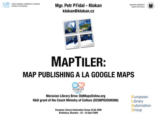
- 1. Mgr. Petr Přidal - Klokan CZECH TECHNICAL UNIVERSITY IN PRAGUE MASARYK UNIVERSITY Geodesy & Cartography Applied Informatics klokan@klokan.cz MAPTILER: MAP PUBLISHING A LA GOOGLE MAPS Moravian Library Brno: OldMapsOnline.org R&D grant of the Czech Ministry of Culture (DC08P02OUK006) European Library Automation Group: ELAG 2009 Bratislava, Slovakia - 22 – 24 April 2009
- 2. MAPTILER - WHAT IS IT? • MapTiler is an easy to use graphical application for online map publishing • You need to georeference your scanned maps! Usually in GIS software (ESRI ArcGIS, MapInfo, ... Grass, QGis, ...) • MapTiler can transform coordinate systems and correctly warp existing map projections • A simple web viewer (OpenLayers, Google Maps API) and KML files (Google Earth, indexing) are directly generated • Standards: OSGEO TMS + OGC WMTS, WMS by proxy
- 4. GOOGLE MAPS OVERLAY DEMO
- 23. Who are users of MapTiler / GDAL2Tiles? National Library of Scotland, NOAA, BRGM, US Forest Survey, ... Companies from: USA (including Google Inc.), New Zealand, Italy, France, UK, Chile... MapTiler development was supported by: Google Inc. : Summer of code 2007, 2008 NIC.CZ: VIP competition BRGM (Bureau des Recherches Geologiques et Minières) Thanks to Czech Technical University in Prague - prof. Veverka MAPTILER - MAP TILE MASHUPS Available for download for free NOW! Standard Windows installer (setup.exe). User support in the user group with archive and fulltext search. Possible commercial support, automation and customization for your project. www.maptiler.org www.oldmapsonline.org