Download to read offline


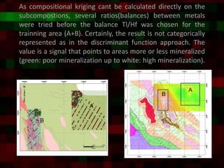


The document presents a methodological approach for mapping gold pathfinder metal ratios using compositional analysis of soil samples in the Amapari region of Brazil, where traditional geochemical exploration is challenged by surface modifications. It details the process of classifying samples into training and validation groups, applying compositional principal component analysis, and utilizing compositional kriging to improve the identification of gold mineralization areas. The study concludes with a proposed methodology that enhances geochemical signals through a series of analytical steps aimed at identifying potential mining targets.


