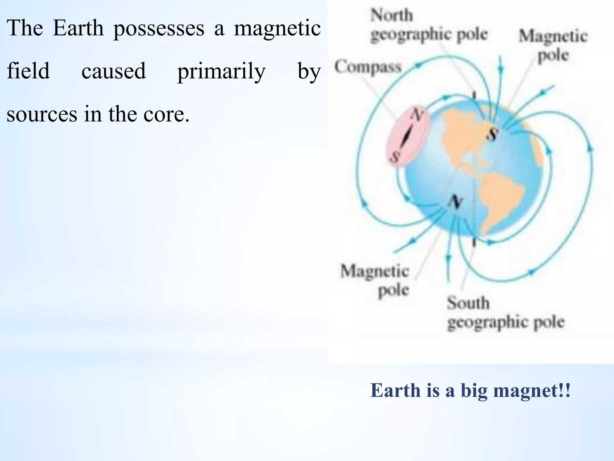
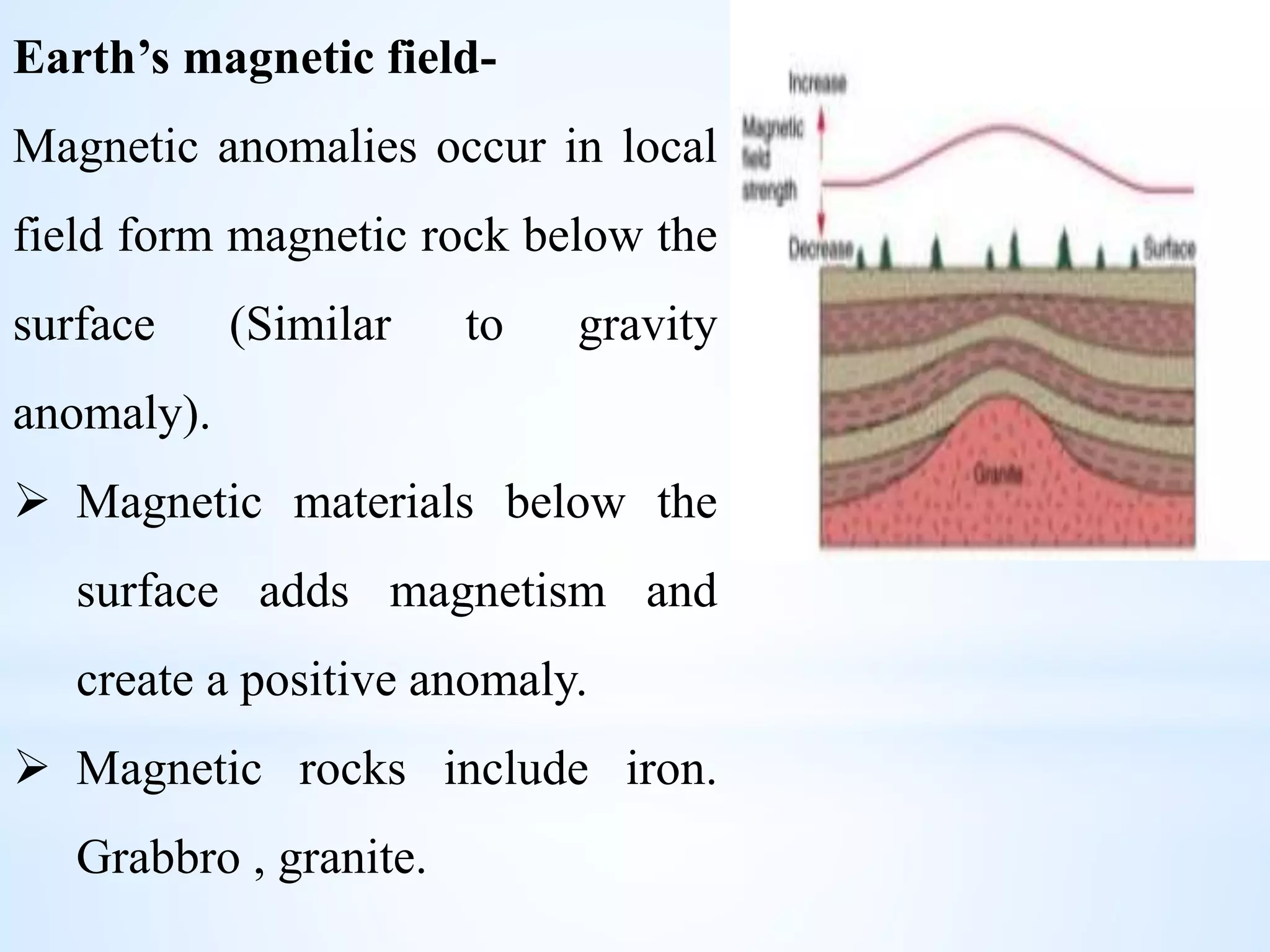
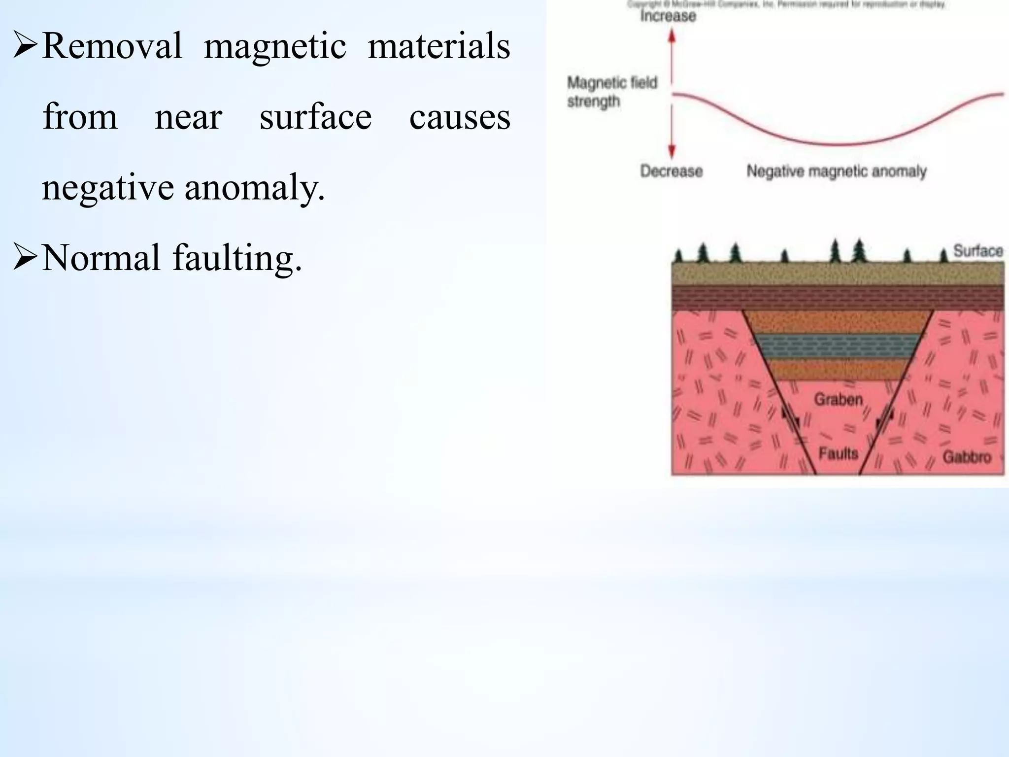
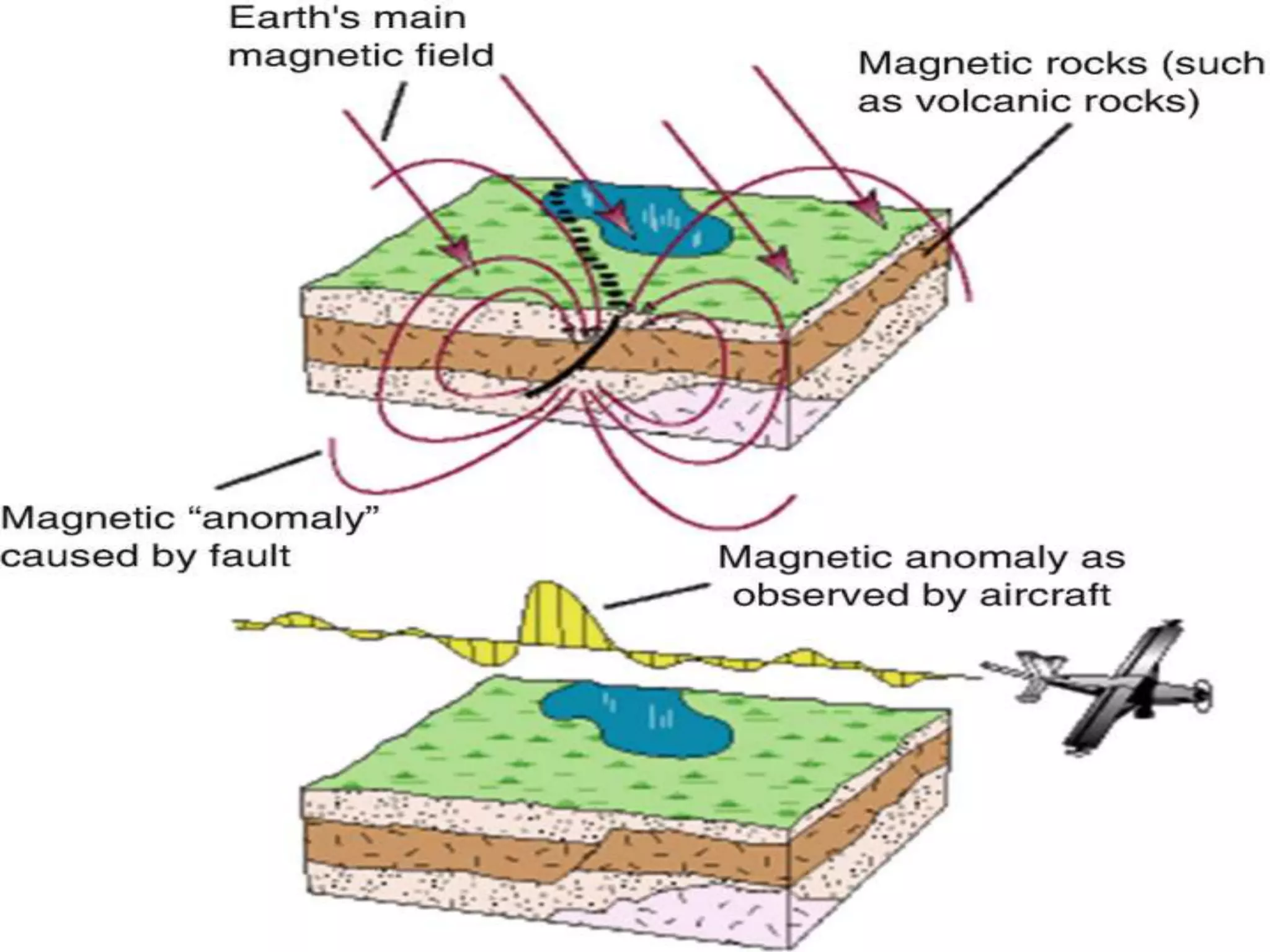
Lecture#10
GeophysicalExplorationMethods
PME 151
Geology for Petroleum And Mining Engineers
L-1,T-1 (20 Batch)
Wednesday, July 26, 2023
Gravity Surveying
Gravity method is a non-destructive geophysical technique
that measures the differences in Earth’s gravitational field at
specific locations, relatively cheap, non-invasive, remote
sensing method.
Principle-
 In gravity surveying, subsurface geology is investigated on
the basis of variations in the Earth’s gravitational field arising
from differences of density between subsurface rocks.
 It measures the variation in acceleration due to gravity.
Methodology
According to the Newton’s law of gravitation –
𝐹 =
𝐺𝑀𝑚
𝑑2
Here, F= Gravitational force between two point masses
M and m.
d= Distance between M and m.
G=Universal gravitational constant
=6.670 x 10⁻¹¹ m3/kgs2
According to Newton’s second law of motion-
𝑎 =
𝐹
𝑀
=
𝐺𝑚
𝑟2
If M is considered as the mass of the Earth and r its radius,
then a is the gravitational acceleration of the Earth.
a is constant assuming Earth a true sphere of uniform
density.
a varies from place to place across the Earth, due to the
effect of latitude, altitude, topography and geology.
Procedure-
• This method measures minute variations in the Earth’s
gravity field. Based on this variation Earth’s subsurface field
and composition can be inferred.
• These variations can be determined by measuring the Earth’s
gravity field at numerous station along travers.
• Correlating the gravity data for elevation, tidal effects,
topography, latitude and instrument drift.
• Gravity field in not uniform everywhere in the earth’s
surface, it varies with the distribution of the mass materials
below
• A gravity survey means calculating the density property of
subsurface materials.
• The higher the gravity value, the denser the rock beneath.
• Modern instrument capable of rapid gravity measurements
are known as gravity meters or gravimeters.
Gravimeter-
• Spring balances carrying a
constant mass . Variation in
the weight of mass caused
by variation in gravity cause
the length of the spring to
vary and give a change in
the gravity.
• Relative gravimeter.
• Absolute gravimeter.
Gravity anomalies-
 An underlying concept is the idea of a causative body,
which is a rock unit of different density from its
surroundings.
 A causative body represents a subsurface zone of
anomalous mass and causes a localized fluctuation in the
gravitational field known as a gravity anomaly i.e.
Deviation from e predefined reference level, Geoid
(Surface over which the gravitational field has equal
value).
Gravity reduction-
Before interpreting the gravity surveys, it is necessary to
correct all the variations which do not cause due to the
variation of subsurface rock density.
 Drift correction
 Latitude correction
 Elevation correction
 Tidal correction
 Applications of Gravity methods-
i. Determine shape of the Earth
ii. Hydrocarbon exploration
iii.Regional geological studies
iv.Iso-static compensation determination
v. Detection of subsurface cavities
vi.Locations of buried rock valleys
vii.Determination of glacier thickness
viii.Tidal oscillations
ix.Basin geometry
Magnetic Surveying
 It aims at investigating Earth’s subsurface geology by
measuring the strength or magnitude of the Earth’s
magnetic field.
 Lateral variation in magnetic susceptibility and remanence
give rise to spatial variations in the magnetic field.
 It is expressed in magnetic anomalies i.e. deviations from
the Earth’s magnetic field.
 Unit of measurement is nanotesla ; I nT= 10−9 Tesla.
 Natural magnetic elements- iron, cobalt, nickel etc.
Magnetic susceptibility-
• Dimensionless property,
measures of how
susceptible a material is to
becoming magnetized.
The Earth possesses a magnetic
field caused primarily by
sources in the core.
Earth is a big magnet!!
Earth’s magnetic field-
Magnetic anomalies occur in local
field form magnetic rock below the
surface (Similar to gravity
anomaly).
 Magnetic materials below the
surface adds magnetism and
create a positive anomaly.
 Magnetic rocks include iron.
Grabbro , granite.
Removal magnetic materials
from near surface causes
negative anomaly.
Normal faulting.
Methodology
The Earth generates a magnetic field as if it were a dipole
magnet. Lines of force radiates from one magnetic pole and
converge at the other. The magnetic axis of the Earth moves
about within a circle of some 10-15 degrees of arc form the
rotational axis.
The force between two magnetic pole may be expressed as
follows
𝐹 =
𝐴𝑀𝑚
𝑑2
Here, F= Force; M and m strengths of the poles; D is the
distance between the poles.
Magnetometer
A magnetometer is a device that measures magnetic field or
magnetic dipole moment. Some magnetometers measure the
direction, strength, or relative change of a magnetic field at a
particular location.
 Disturbances in the Earth’s magnetic field are recorded by
the magnetometer.
 Data is processed by computer software to construct a
colored map.
Applications of Magnetic surveying-
i. Basin thickness estimation
ii. Determining fault types
iii. Locating mining prospect
iv. Finding buried elements
v. Evaluating ocean-floor spreading
vi. Mineral exploration

Lecture-10.pptx

  • 1.
    Lecture#10 GeophysicalExplorationMethods PME 151 Geology forPetroleum And Mining Engineers L-1,T-1 (20 Batch) Wednesday, July 26, 2023
  • 2.
    Gravity Surveying Gravity methodis a non-destructive geophysical technique that measures the differences in Earth’s gravitational field at specific locations, relatively cheap, non-invasive, remote sensing method. Principle-  In gravity surveying, subsurface geology is investigated on the basis of variations in the Earth’s gravitational field arising from differences of density between subsurface rocks.  It measures the variation in acceleration due to gravity.
  • 3.
    Methodology According to theNewton’s law of gravitation – 𝐹 = 𝐺𝑀𝑚 𝑑2 Here, F= Gravitational force between two point masses M and m. d= Distance between M and m. G=Universal gravitational constant =6.670 x 10⁻¹¹ m3/kgs2
  • 4.
    According to Newton’ssecond law of motion- 𝑎 = 𝐹 𝑀 = 𝐺𝑚 𝑟2 If M is considered as the mass of the Earth and r its radius, then a is the gravitational acceleration of the Earth. a is constant assuming Earth a true sphere of uniform density. a varies from place to place across the Earth, due to the effect of latitude, altitude, topography and geology.
  • 5.
    Procedure- • This methodmeasures minute variations in the Earth’s gravity field. Based on this variation Earth’s subsurface field and composition can be inferred. • These variations can be determined by measuring the Earth’s gravity field at numerous station along travers. • Correlating the gravity data for elevation, tidal effects, topography, latitude and instrument drift.
  • 6.
    • Gravity fieldin not uniform everywhere in the earth’s surface, it varies with the distribution of the mass materials below • A gravity survey means calculating the density property of subsurface materials. • The higher the gravity value, the denser the rock beneath. • Modern instrument capable of rapid gravity measurements are known as gravity meters or gravimeters.
  • 7.
    Gravimeter- • Spring balancescarrying a constant mass . Variation in the weight of mass caused by variation in gravity cause the length of the spring to vary and give a change in the gravity. • Relative gravimeter. • Absolute gravimeter.
  • 8.
    Gravity anomalies-  Anunderlying concept is the idea of a causative body, which is a rock unit of different density from its surroundings.  A causative body represents a subsurface zone of anomalous mass and causes a localized fluctuation in the gravitational field known as a gravity anomaly i.e. Deviation from e predefined reference level, Geoid (Surface over which the gravitational field has equal value).
  • 9.
    Gravity reduction- Before interpretingthe gravity surveys, it is necessary to correct all the variations which do not cause due to the variation of subsurface rock density.  Drift correction  Latitude correction  Elevation correction  Tidal correction
  • 10.
     Applications ofGravity methods- i. Determine shape of the Earth ii. Hydrocarbon exploration iii.Regional geological studies iv.Iso-static compensation determination v. Detection of subsurface cavities vi.Locations of buried rock valleys vii.Determination of glacier thickness viii.Tidal oscillations ix.Basin geometry
  • 11.
    Magnetic Surveying  Itaims at investigating Earth’s subsurface geology by measuring the strength or magnitude of the Earth’s magnetic field.  Lateral variation in magnetic susceptibility and remanence give rise to spatial variations in the magnetic field.  It is expressed in magnetic anomalies i.e. deviations from the Earth’s magnetic field.  Unit of measurement is nanotesla ; I nT= 10−9 Tesla.  Natural magnetic elements- iron, cobalt, nickel etc.
  • 12.
    Magnetic susceptibility- • Dimensionlessproperty, measures of how susceptible a material is to becoming magnetized.
  • 13.
    The Earth possessesa magnetic field caused primarily by sources in the core. Earth is a big magnet!!
  • 14.
    Earth’s magnetic field- Magneticanomalies occur in local field form magnetic rock below the surface (Similar to gravity anomaly).  Magnetic materials below the surface adds magnetism and create a positive anomaly.  Magnetic rocks include iron. Grabbro , granite.
  • 15.
    Removal magnetic materials fromnear surface causes negative anomaly. Normal faulting.
  • 17.
    Methodology The Earth generatesa magnetic field as if it were a dipole magnet. Lines of force radiates from one magnetic pole and converge at the other. The magnetic axis of the Earth moves about within a circle of some 10-15 degrees of arc form the rotational axis. The force between two magnetic pole may be expressed as follows 𝐹 = 𝐴𝑀𝑚 𝑑2 Here, F= Force; M and m strengths of the poles; D is the distance between the poles.
  • 18.
    Magnetometer A magnetometer isa device that measures magnetic field or magnetic dipole moment. Some magnetometers measure the direction, strength, or relative change of a magnetic field at a particular location.  Disturbances in the Earth’s magnetic field are recorded by the magnetometer.  Data is processed by computer software to construct a colored map.
  • 19.
    Applications of Magneticsurveying- i. Basin thickness estimation ii. Determining fault types iii. Locating mining prospect iv. Finding buried elements v. Evaluating ocean-floor spreading vi. Mineral exploration