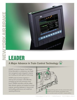
The document describes LEADER, a train management system that assists locomotive engineers in reducing fuel consumption and effectively managing trip times through technology. It analyzes locomotive data to improve train handling performance and efficiencies. LEADER captures real-time train operation data using onboard GPS and computers, and transmits it using radio to remote servers for analysis. This helps identify optimal train handling techniques and improves safety, while typically paying for itself through reduced fuel and other operating costs within two years.
GPS Tracking Business Opportunities for CarriersDrew Davitian
. Our products and solutions are especially focused on enabling the following types of applications:
Personal and commercial vehicle location
Vehicle navigation, safety and security
Meter Reading
Home and industrial alarms
Mobile payment, verification, and stored value
Tiger Dispatch is a web application which supervisors and field teams who work in Tiger Team project use for: Assignment Management, Live RSSI, VSWR and alarm info, Live Map Tracker, Directions and distance estimates, Weather Forecast, Site info, Reporting.
Established in 2000, NexTraq provides the leading GPS fleet tracking solution in the telematics industry. The NexTraq® solution is a cloud-based application that enables service and distribution businesses to optimize fleet operations while reducing operational costs and maximizing revenue. Based in Atlanta, NexTraq customers achieve ROI in as little as one month. December 4, 2014 – NexTraq® has been named a silver winner in the Small or Medium Business Service of the Year category in Best in Biz Awards 2014, the only independent business awards program judged by members of the press and industry analysts.
The CAN Bus (Controller Area Network) is a serial two-wire full-duplex communication specification which conforms to the international standard ISO-11898 standard communication interface. The protocol of the CAN bus allows multiple nodes in a system to communicate efficiently with each other. It is already widely used in vehicle and vessel internal components; in recent years, it has seen adoption in data communications and control in industrial industry. The CAN Bus is used on the data transfer and control between controllers, a common setup in various industries. Examples include military use, electric power measurement, building automation, semiconductor equipment and elevator networks. This type of monitoring system is made up of many single-device combinations. To verify that things are working properly, one relies upon the integrity of software.
Rachna ERP-Fleet Management module is a complete fleet management system designed for efficiently managing fleet operation.
Cloud Based Fleet Management System. Now no need to invest on hardware or package software. Rachna Fleet is now on SaaS based model for Fleet owner to manage there Fleets.
INTA created a stable and flexible data acquisition system that can be used on all their UAV for flight testing and operations.
The System
Acra KAM-500 data acquisition unit (DAU) connected to a variety of sensors. A network switch provides the communication backbone for the DAU interface with the flight control system.
The Results
30% reduction in weight of the data acquisition system
Reduced instrumentation, configuration and programming time by 40%
Fully integrated future proof air-to-ground system
More details available at www.cwc-ae.com.
Fleet Advantage Fleet Safety quick overview of the ELD rule, which is intended to help create a safer work environment for drivers and make it easier, faster to accurately track, manage and share Records Of Duty Status (RODS) data.
CAN 2.0 to CAN FD: Realize for what reason CAN FD underpins bigger payload than CAN 2.0 and how might you conquer the difficulties identified with relocation from CAN 2.0 to CAN FD. This blog reveals some insight into Mixed Networks and External CAN FD controller.
https://www.embitel.com/blog/embedded-blog/challenges-your-automotive-team-may-confront-during-migration-from-can-2-0-to-can-fd
GPS Vehicle Tracker Australia: Cam Tracker Live provides a wide range of real-time GPS tracking, Track camera and best features Vehicle tracking device.
We NSG India, a ESRI Gold Partner, have been working with many companies on a collaborative mode and delivering solutions on ESRI platform configured to their businesses.
NSG has global presence in India, UAE, NewZealand, United states and we offer services in the following ESRI and Microsoft technology areas: NSGI has a special focus on application development, geo-database implementation and web deployment. We develop applications across the entire ESRI suite of products – from ArcPad to ArcGIS Server and ArcGIS Online,
ArcFM Desktop and ArcFM Server based application customisation using.NET, Java using SQL Server and Oracle spatial databases.
We are ESRI-Centric working on Strategic GIS Consulting, Enterprise GIS Implementations catering to specific vertical markets and domains like Ports, Building Inspection Management and Citizen centric incident and complaints management system for Local Government (Municipal Councils, Counties), Climate Change, Marine, Utilities and Spatial Data Infrastructure.
We have expertise in small to medium to large scale ESRI and Microsoft Based projects. We specialize in offshore-based application development & have proven track record in providing turnkey solution to GIS Companies and Governments. We provide offshore technical and development support on Geocortex Spatial application infrastructure with future proof technologies with minimum custom code requirements. Our offshore development model has a proven cost saving and enable the organization to:
1. Create GIS applications that meet the demand for maps and applications for administrators and project stakeholders;
2. Provide end-users with simple and repeatable processes for accessing information, inside applications tailored to their needs.
3. Reduce the cost of development, support, maintaining/administering applications.
4. Share geospatial information with internal or external stakeholders on an array of desktop/mobile devices.
I have also attached a brief presentation on our corporate background and service capabilities. If you need any additional information or have a query, please do feel free to contact us.
Logix Network provides an online networking platform for manufacturers to streamline the information flow. It’s one of its kind network which helps manufacturers to streamline Inbound & Outbound logistics. And gives freedom to manage all the dispatches on a single platform from multiple logistics providers.
Know More: https://logixgrid.com/transport-management-system/
Cassidian’s Barracuda technology demonstrator UAV flight tests advanced technologies in realistic conditions
The System
Two Acra KAM-500 data acquisition units (DAUs), equipped with COTS modules used to monitor various avionics buses and analog sensors, in a master slave configuration
The Results
Successful completion of a UAV technology demonstrator flight test campaign
Development of a flexible, low-cost DAS tightly integrated with in-house systems
Reliable accurate data delivered on time to the onboard and ground flight test systems
More details available at www.cwc-ae.com.
overview of plc and dcs...
A general information about the common plcs used and how SCADA software is used for virtualising the entire plant equipments and sensors and control them within a single control room.
Air Quality Data Acquisition and Management SystemsAgilaire LLC
AirVision.®
Nice Thought Meets Well Thought Out.
Introducing AirVision. The first air monitoring system envisioned by industry
veterans and engineered from the ground up to provide automated data validation
from many different data sources. Simply, quickly and efficiently. A system that
can truly make you breathe easier. A system that’s truly the future, here today.
AirVision from Agilaire addresses monumental needs which existing ambient
monitoring systems can’t.
• Automated data handling from many different data paths
• Flexible data processing to assure data quality
• Broadband and wireless options to improve data access and visibility
With AirVision, your data will be accurate.
Immediate. Reliable. Easily available.
The pressure is off. Breathe.
Developing safety autonomous driving solutions based on the adaptive AUTOSAR ...Andrei Kholodnyi
This presentation provides an example of an implementation of Adaptive AUTOSAR implementation based on VxWorks RTOS from Wind River. As one of the very few solutions available on the market, VxWorks RTOS serves as a foundation for the Adaptive AUTOSAR-based autonomous driving development.
SkidFleet, Lift Truck Fleet Operational Management Information SystemTed Jurca
SkidFleet wireless connects your entire material handling fleet, capturing vehicle and operator data to provide operational insights about your activities unreal time
Analyze performance and operations of truck fleets in real timeAltair
Altair’s event processing and data visualization tools enable fleet operators to analyze critical data streaming in from sensors and other sources. This real-time visibility into vehicle and driver performance helps reduce operating costs, improve driver safety, and increase fleet productivity. Analysts can display maps showing the current position of all assets, examine route deviations, program alerts on any set of parameters, and compare drivers’ behavior. Analysts can design and modify analytical dashboards as needed without writing a single line of code.
Analyze performance and operations of truck fleets in real time
leader
1. P R O D U C T I V I T Y T H R O U G H T E C H N O L O G Y
A Major Advance in Train Control Technology
LEADER®
(Locomotive Engineer Assist/Display
& Event Recorder) is a revolutionary new freight
train management system designed to improve
train handling and yield significant fuel savings.
LEADER assists locomotive engineers in
reducing fuel consumption while effectively
managing trip time and minimizing in-train
forces. LEADER’s back-office software utilities
help railroads organize and analyze locomotive
engineer operating databases to improve both
train-handling performance and overall train
operating efficiencies.
LEADER
1
3
2
Global positioning system and radio communication system
LEADER locomotive engineer assist/display monitor
Event recorder/computer and Profiler®
computer platform
1
2
3
2. On-Board Equipment
LEADER®
on-board electronic equipment captures,
stores, and reports real-time data collected as the
train works in normal operation, and includes a
cab display that shows train dynamics in real time
as the train moves across the territory. Profiler®
provides all LEADER functionality without the in-cab
display. Both LEADER and Profiler create substantial
fuel savings without compromising cycle time
or in-train forces.
Profiler
Profiler is a specific configuration of LEADER that
does not incorporate the in-cab display/computer
to collect and report train performance data for
the purpose of post-trip analysis. Profiler uses GPS
and a single board computer (SBC) installed on
the locomotive to capture and store data, and
an array of communications channels including
spread spectrum radio, to
transmit LEADER data to
a base station. The
base station then
automatically
processes the data for analysis. As with a conventional LEADER
installation, the data is available for use at the base station, or it
can be delivered to the railroad’s network for analysis throughout
the organization.
Profiler captures engineers’ performance metrics and real-time
operation data to identify the optimal or “Golden Run” best suited to
meet the railroad’s goals. Profiler has all the hooks in place to allow
it to be upgraded to full LEADER functionality.
Off-Board Equipment
LEADER/Profiler off-board equipment includes data servers that
communicate with the on-board equipment via wayside radio
to automatically move data from the locomotive to the railroad
computer network. LEADER/Profiler is designed to interface with all
common computer systems, and establishes a high bandwidth RF
link to the wayside. The off-board equipment also includes playback
stations, located within the railroad, that allow the user to manually or
automatically process performance data to profile the operation, find
trouble spots, or ensure proper adherence to operating policy.
Radio Communication
LEADER radio communication employs state-of-the-art spread
spectrum radio technology to communicate data between
locomotives when on the move, and from the locomotives to LEADER
base stations when the locomotives enter a base station zone. All
data is transmitted automatically without manual intervention.
Fast Payback
Payback on the investment for a full LEADER
system is typically less than two years. The energy-
efficient train handling provided by LEADER results
in very substantial fuel savings, less wear and tear
on track, couplers and knuckles, wheel sets, and
brake shoes—which further reduces operating and
life-cycle costs.
LEADER enables the engineer to better manage
in-train forces, which reduces lading damage and
subsequent claims. In addition, accident insurance
costs associated with train separations and
derailments are reduced, while safety is increased,
lowering insurance and liability costs. And LEADER
provides the data required for creating more cost-
effective scheduling and operating procedures—
increasing railroad efficiency and competitiveness.
Reliable Accuracy
Drawing from a track database of 120,000
miles, LEADER provides predictive algorithmic
calculations of in-train forces that are over 95%
accurate, as demonstrated in field tests. TDS’ train
dynamic track profiles are the most accurate in
the industry, providing information that defines the
“Golden Run” for any type of train service.
Responsive NYAB Support
Every LEADER system is backed by the expert
engineering and customer service of the
Train Dynamics Services Group in Ft. Worth,
Texas, and the superior New York Air Brake
field support delivered from locations across
the United States and Canada.
LEADER®
Dynamics
Models
Back-Office®
Tools
Advanced
Event Recorder
Playback
Driver Assist
Based On
Golden Run
Analysis
Databases
Consist
Track Profile GPS
Human-
Machine
Interface
Profiler®
Analyzed
Run Data
Run Data
Raw Data:
Sensor Array
or LSI
On-Board
Storage
Profiler provides
all LEADER functionality
without the in-cab display.
The system includes on-board and remote (off-board)
equipment, in either of two available configurations.
LEADER In-Cab Display
The rugged, sunlight-readable LEADER cab display provides the engineer
with a wide range of information including track topology, train trajectory,
real-time status of trail and remote locomotives in the consist, brake
system status, and in-train forces. LEADER software applications are highly
integrated with existing on-board display/computers, saving space and cost
as well as improving system reliability, and can be installed as an overlay
with NYAB computer platforms.
Playback System
The LEADER playback system assembles the logfiles from all the locomotives
in the train automatically, and identifies the train’s correct location for
analysis. The integrated GPS system allows LEADER to always know
where the train is.
On-Board Capabilities/Functions
LEADER operates in an information-only mode, or in a proactive-assist
mode, by providing recommended throttle and brake settings. In either
mode, it provides information that will save fuel and improve safety.
LEADER also functions as an event recorder, and its underlying simulator
technology easily allows its real-world data to be downloaded for
in-depth study and replay on a simulator—ideal for engineer training
and incident investigation. LEADER integrates input from the EOT device,
trail and remote units, and any microcomputer-based system, including
distributed power and ECP brake systems.
Shared Knowledge
• Enable all your engineers, including the very best, to
become even better.
• Set operational goals based on a complete and thorough
understanding of how your operation works today, and then
monitor to ensure that your goals are being achieved.
• Monitor engineer performance from a road foreman’s desk with
regular, automatic analysis that enables proactive management
of negative trends before they become problems.
• Understand common, objective measures of train performance
shared with the road foreman and/or engineer.
The LEADER playback
screen features control
(bottom panel) and
status (far right)
windows adjacent to
the LEADER display.
All data is collected and
processed by LEADER/Profiler
without manual intervention.
3. New York Air Brake, 748 Starbuck Avenue, Watertown, New York 13601 (315) 786-5431
Train Dynamics Systems, 8912 Oak Grove Road, Ft. Worth, Texas 76140 (817) 293-7005
www.nyab.com
17 Draw bar force (behind last locomotive
in lead consist)
18 End-of-train status
19 GPS status
20 Current time
21 Locomotive consist & status
22 Software version information
23 Driver assist prompt
1 Track curvature representation
2 Horizontal view of track
3 Overhead view of track
4 Bridge
5 Signal
6 Crossing
7 Draft / buff forces
8 Transient (run-in /run-out)
forces
9 Brake pipe pressure
10 Brake cylinder pressure
11 Brake pipe reduction
12 Minimum recommended safe
reduction indication
13 Head end information section
14 Fuel consumed
15 Speed
16 Acceleration
22
1
2
3 4
5
6
7 8
9
10
11
12
13 13 14
15
16
17
18
19
20
21
23