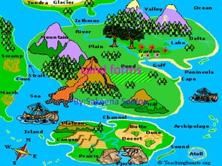
Land forms sakeena saidou
•Download as PPTX, PDF•
1 like•168 views
Bodies of water include lakes, oceans, ponds, rivers, and lagoons. Volcanoes can create or destroy land and are dangerous. Caves provide habitat for bears and bats. Glaciers are moving ice and canons are deep valleys carved by erosion.
Report
Share
Report
Share

Recommended
Water bodies
This document summarizes the major water bodies of Earth. It explains that 3/4 of the Earth's surface is covered by water in various forms called water bodies. The largest water bodies are the five oceans: Pacific, Atlantic, Indian, Arctic, and Antarctic oceans. It also describes seas as large water bodies smaller than oceans, which can be marginal seas partly enclosed by land or inland seas covering central land areas. Minor water bodies include bays, lakes, gulfs, lagoons, straits, and rivers.
Landforms and bodies of water
Topography refers to the physical features of a place or region, which can be natural or man-made. Topography is caused by volcanic eruptions, soil erosion from water and wind, and the flow of water from high to low elevations. The document defines and describes various landforms like mountains, hills, islands, deserts, plains, valleys, canyons, and plateaus. It also defines bodies of water like oceans, seas, rivers, lakes, waterfalls, and coasts. Major oceans, deepest ocean trenches, historically important rivers, and examples of large lakes are identified.
Bodies of water
The document discusses the five main oceans of the world - the Pacific, Atlantic, Indian, Southern, and Arctic oceans. It provides data on the size and depths of each ocean, with the Pacific being the largest and the Mariana Trench in the Pacific being the deepest location at over 36,000 feet deep. Rivers are described as large bodies of fresh water that flow across land into seas or oceans, while lakes are bodies of fresh water surrounded by land.
Major bodies of water
The document discusses the major bodies of water on Earth. It notes that there are four oceans - Pacific, Atlantic, Indian, and Arctic. The Pacific is the largest and deepest. It also describes that there are five oceans with the addition of the Southern Ocean north of Antarctica in 2000. Coral reefs form in shallow, warm seas and are made of coral polyps' skeletons. The oceans are divided into three zones - the sunlit zone down to 650 feet, the twilight zone down to 3,300 feet, and the sunless zone down to 13,100 feet with different types of life in each zone.
Landforms powerpoint
This document defines and describes various landforms and bodies of water. It explains that a bay is an area of water bordered by land on three sides, a gulf is a larger body of water partly surrounded by land, and a peninsula is a piece of land surrounded by water on three sides. It also defines deltas, isthmuses, straits, lakes, mountains, hills, plains, plateaus, rivers, waterfalls, fjords, valleys, glaciers, archipelagos, seas, and oceans.
Quiz about landforms
Landforms are natural shapes on the Earth's surface and include plains, plateaus, hills, mountains, valleys, depressions, canyons, peninsulas, islands, archipelagos, coasts, lakes, rivers, capes, gulfs, bays, and straits or channels. Plains are flat areas, plateaus are flat, high areas, hills are small elevations, and mountains are high areas surrounded by lower land. Valleys are low areas between high lands, depressions are lower areas, and canyons are deep, steep valleys.
Oceans continents
There are five major oceans - Arctic, Indian, Atlantic, Pacific, and Southern - that together cover almost three-quarters of the Earth's surface. Salt in the oceans comes from rocks that have been worn down by water over time, releasing salt. Sand is formed from rocks that have broken apart into tiny grains, and tides are caused by the gravitational pull of the moon, causing water levels to rise and fall daily. Waves are mostly produced by wind blowing over the surface of the water.
Bodies Of Water
Oceans, rivers, and lakes are the three main types of bodies of water on Earth. Oceans are large bodies of salt water surrounding continents, with the Pacific being the largest. Rivers are flowing bodies of fresh water that cross land and empty into seas or oceans. Lakes are large bodies of fresh water surrounded by land on all sides, such as Lake Kaweah in Tulare County.
Bodies of water. adriana, leire and ainara
Most of Earth is covered in water, including five major oceans - Pacific, Atlantic, Indian, Southern, and Arctic. There are also smaller seas and lakes surrounded by land. Rivers are bodies of moving water that flow into oceans, seas, lakes or other rivers, with examples given of the Camarmilla, Henares, and Tajo rivers ultimately draining into the Atlantic Ocean. The document provides a basic overview of the different types of bodies of water on Earth.
Land forms
This document defines and provides brief descriptions of different types of landforms. It explains that mountains are the highest kind of land with peaks, hills rise above surrounding land with rounded tops, islands are surrounded by water, deserts are dry with few plants due to lack of rain, rivers are long bodies of flowing water through land, lakes are bodies of water surrounded by land, oceans are large bodies of salty water covering large areas, plains are flat land, valleys are low land between hills or mountains, and plateaus are large elevated areas rising steeply above surrounding land.
Landforms diva jamaria
Canyons are deep, narrow valleys that sometimes contain streams, while caves are dark, cool, and wet places that require specialized adaptations for the creatures living there. Mountains have snow at their peaks and rise sharply from the land, as volcanoes explode lava and eruptions form hard rock. Gulfs are portions of sea almost surrounded by land with a narrow opening, whereas islands are smaller than continents and completely encircled by water. Bays connect to oceans or lakes, and harbors shelter ships from storms in connected bodies of water. Cliffs are tall, steep slopes of rock or soil, and hills form from erosion and are part of raised areas of earth's crust. Glaciers contain ice and have pointed
Read about landforms 2014 (1)
This document provides information about various types of landforms. It includes definitions and facts about volcanoes, canyons, waterfalls, plains, mountains, rivers, caves, oceans, valleys, islands, deltas, peninsulas, lakes, hills, and continents. For each landform, it gives a brief description of its characteristics and formation and often links to additional online resources for learning more.
ocean and man
The document discusses the formation of oceans on Earth. As the molten surface cooled over time, volcanic gases formed an atmosphere and water condensed from the atmosphere to form oceans. Life then emerged in the oceans. The three major oceans - Pacific, Atlantic, and Indian - formed as the supercontinent Pangaea broke apart. These oceans have varying depths, islands, currents, and features such as coral reefs and mid-ocean ridges. The document also describes how salinity and temperature vary in ocean waters due to factors like evaporation, rainfall, and ocean currents.
Bodies of Water
The document describes four major bodies of water: oceans, gulfs, rivers, and lakes. Oceans are the largest body of water and have salty water. Gulfs are bodies of ocean water surrounded by land on three sides. Rivers are streams of water that flow across land. Lakes are bodies of fresh water surrounded by land.
Earth’s water forms
The document provides information about various bodies of water on Earth. It discusses that 3/4 of the Earth's surface is covered by water, most of which is found in the oceans. The four main oceans - Pacific, Atlantic, Indian, and Arctic - contain salt water and cover about half of the Earth's surface. Smaller bodies of water like seas, bays, lakes, rivers, and springs are also described. The document also lists and provides details about many bays found within the Philippines.
Landforms
This document describes different types of landforms including rivers, lakes, oceans, waterfalls, islands, canyons, mountains, volcanoes, and plains. Rivers run downhill and can power mills. Lakes are large bodies of water surrounded by land that are good for fishing. Oceans take up most of the Earth and are salty. Waterfalls occur when there is a sharp drop off from a river. Islands can be reached by boat as they are surrounded by water. Canyons have very steep sides carved out over time by erosion. Mountains are the tallest landforms with snowy peaks. Volcanoes have vents that spew lava, steam, and rocks. Plains are broad and flat areas that were once under
Bodies of water
The document discusses different types of bodies of water on Earth. It states that about 3/4 of Earth's surface is covered by water, but only 1/2 cup out of a gallon jug represents the amount of fresh water. The largest oceans are the Pacific, Atlantic, Indian, and Arctic. Lakes are bodies of water surrounded by land, and the Great Lakes are located in Michigan. Rivers contain fresh water and flow into larger bodies of water. Ponds and streams are smaller than lakes and rivers.
Water forms of the philippines
This document describes the various water forms found in the Philippines, including oceans, seas, lakes, channels, waterfalls, bays, straits, gulfs, rivers, streams, creeks, and springs. It provides examples of each water form type in the Philippines and notes key characteristics, such as oceans being the largest bodies of water, seas being salty, lakes containing fresh water, and rivers flowing toward the sea.
Bodies of water
Power Point done and used to teach 2nd and 3rd Graders in Sciences. (Bodies of water- seas-oceans...)
Geography Vocabulary
This presentation was prepared for Deaf and hard of hearing students in Ms. Amy LC's social studies classes.
Seas, Lakes and Rivers (Project in Science)
This powerpoint presentation is for the study of some waterforms that are found in our beautiful and blessed planet, Earth. Please enjoy and comment what kind of powerpoint do you want next :).
Landformppt quiz
This document is a quiz about landforms that provides descriptions of 24 different landforms and asks the reader to identify each one out of 3 multiple choice options. It tests knowledge of common geographic features including glaciers, valleys, loess, deserts, plateaus, peninsulas, cliffs, canyons, plains, swamps, waterfalls, archipelagos, isthmuses, capes, mesas, dunes, deltas, faults, mountains, valleys, prairies, and volcanoes.
major water bodies
This document provides an overview of major water bodies on Earth. It introduces the hydrosphere, which includes oceans, seas, ice sheets, underground water, and atmospheric water vapor. There are five major oceans: the Pacific, Atlantic, Indian, Southern, and Arctic Oceans. The Pacific Ocean is the largest and deepest ocean, containing the Mariana Trench. The Atlantic Ocean is the second largest and saltiest ocean. The Indian Ocean is triangular in shape and contains the Arabian Sea and Bay of Bengal. The Southern Ocean surrounds Antarctica, while the Arctic Ocean is the smallest and shallowest ocean located around the North Pole. Oceans are important as they help regulate temperature and provide food, oil/gas resources, and
Land and Water forms
This document provides an introduction to common land and water forms for second graders. It defines the ocean, continent, river, island, lake, hill, plain, mountain, peninsula, and bay. It then instructs students to choose a land or water form to research with a buddy, find three interesting facts about it using a provided search engine, and create a PowerPoint to share with the class.
Landforms review
This document defines and provides examples of different types of landforms and physical regions. It discusses 8 major regions: 1) mountain, 2) valley, 3) river basin, 4) desert, 5) plains, 6) coastal plain, 7) island, and provides information on key landforms within each region, such as mountains, plateaus, valleys, deltas, mesas, buttes, peninsulas, bays, gulfs, seas, islands, straits, and isthmuses. Examples are given for many of the landforms.
Bodies of water
The water cycle describes the continuous movement of water on, above, and below the surface of the Earth. Water can change between liquid, solid, and gas states in this cycle. In its purest form, water is a chemical compound made up of two hydrogen atoms and one oxygen atom. Bodies of flowing water include rivers, creeks, brooks, and canals, which vary in size and flow. Bodies of non-flowing water include oceans, lakes, ponds, reservoirs, sloughs, marshes, and estuaries, and also vary in size and salinity.
The philippine landforms
The document describes various landforms found in the Philippines. It discusses mountains, volcanoes, plains, hills, plateaus, mountain ranges, peninsulas, and valleys. Mountains rise high above the surrounding land and can be steep and difficult to climb. Volcanoes have openings that erupt hot rocks and lava. Plains are large, flat, low-lying areas where many towns and cities are located. Hills are smaller and lower than mountains. Plateaus are flat areas at the top of mountains. Mountain ranges are chains of mountains separated by passes or valleys. Peninsulas jut out from land into water on three sides. Valleys are low-lying areas between hills or mountains. Examples of each landform type in
Bodies of water
There are many bodies of water in the United States including lakes, rivers, and oceans. Some important rivers discussed include the Mississippi River, which is the largest river system in North America, the Colorado River, and the Arkansas River. The Great Lakes along the US-Canada border were also covered, including Lake Erie being the southernmost, shallowest, and smallest by volume of the five lakes. Finally, the three oceans bordering the US were mentioned with the Pacific Ocean identified as the largest oceanic division.
Anonymous Identity in PostSecret
The document discusses the benefits of exercise for mental health. Regular physical activity can help reduce anxiety and depression and improve mood and cognitive function. Exercise causes chemical changes in the brain that may help protect against mental illness and improve symptoms.
More Related Content
What's hot
Bodies of water. adriana, leire and ainara
Most of Earth is covered in water, including five major oceans - Pacific, Atlantic, Indian, Southern, and Arctic. There are also smaller seas and lakes surrounded by land. Rivers are bodies of moving water that flow into oceans, seas, lakes or other rivers, with examples given of the Camarmilla, Henares, and Tajo rivers ultimately draining into the Atlantic Ocean. The document provides a basic overview of the different types of bodies of water on Earth.
Land forms
This document defines and provides brief descriptions of different types of landforms. It explains that mountains are the highest kind of land with peaks, hills rise above surrounding land with rounded tops, islands are surrounded by water, deserts are dry with few plants due to lack of rain, rivers are long bodies of flowing water through land, lakes are bodies of water surrounded by land, oceans are large bodies of salty water covering large areas, plains are flat land, valleys are low land between hills or mountains, and plateaus are large elevated areas rising steeply above surrounding land.
Landforms diva jamaria
Canyons are deep, narrow valleys that sometimes contain streams, while caves are dark, cool, and wet places that require specialized adaptations for the creatures living there. Mountains have snow at their peaks and rise sharply from the land, as volcanoes explode lava and eruptions form hard rock. Gulfs are portions of sea almost surrounded by land with a narrow opening, whereas islands are smaller than continents and completely encircled by water. Bays connect to oceans or lakes, and harbors shelter ships from storms in connected bodies of water. Cliffs are tall, steep slopes of rock or soil, and hills form from erosion and are part of raised areas of earth's crust. Glaciers contain ice and have pointed
Read about landforms 2014 (1)
This document provides information about various types of landforms. It includes definitions and facts about volcanoes, canyons, waterfalls, plains, mountains, rivers, caves, oceans, valleys, islands, deltas, peninsulas, lakes, hills, and continents. For each landform, it gives a brief description of its characteristics and formation and often links to additional online resources for learning more.
ocean and man
The document discusses the formation of oceans on Earth. As the molten surface cooled over time, volcanic gases formed an atmosphere and water condensed from the atmosphere to form oceans. Life then emerged in the oceans. The three major oceans - Pacific, Atlantic, and Indian - formed as the supercontinent Pangaea broke apart. These oceans have varying depths, islands, currents, and features such as coral reefs and mid-ocean ridges. The document also describes how salinity and temperature vary in ocean waters due to factors like evaporation, rainfall, and ocean currents.
Bodies of Water
The document describes four major bodies of water: oceans, gulfs, rivers, and lakes. Oceans are the largest body of water and have salty water. Gulfs are bodies of ocean water surrounded by land on three sides. Rivers are streams of water that flow across land. Lakes are bodies of fresh water surrounded by land.
Earth’s water forms
The document provides information about various bodies of water on Earth. It discusses that 3/4 of the Earth's surface is covered by water, most of which is found in the oceans. The four main oceans - Pacific, Atlantic, Indian, and Arctic - contain salt water and cover about half of the Earth's surface. Smaller bodies of water like seas, bays, lakes, rivers, and springs are also described. The document also lists and provides details about many bays found within the Philippines.
Landforms
This document describes different types of landforms including rivers, lakes, oceans, waterfalls, islands, canyons, mountains, volcanoes, and plains. Rivers run downhill and can power mills. Lakes are large bodies of water surrounded by land that are good for fishing. Oceans take up most of the Earth and are salty. Waterfalls occur when there is a sharp drop off from a river. Islands can be reached by boat as they are surrounded by water. Canyons have very steep sides carved out over time by erosion. Mountains are the tallest landforms with snowy peaks. Volcanoes have vents that spew lava, steam, and rocks. Plains are broad and flat areas that were once under
Bodies of water
The document discusses different types of bodies of water on Earth. It states that about 3/4 of Earth's surface is covered by water, but only 1/2 cup out of a gallon jug represents the amount of fresh water. The largest oceans are the Pacific, Atlantic, Indian, and Arctic. Lakes are bodies of water surrounded by land, and the Great Lakes are located in Michigan. Rivers contain fresh water and flow into larger bodies of water. Ponds and streams are smaller than lakes and rivers.
Water forms of the philippines
This document describes the various water forms found in the Philippines, including oceans, seas, lakes, channels, waterfalls, bays, straits, gulfs, rivers, streams, creeks, and springs. It provides examples of each water form type in the Philippines and notes key characteristics, such as oceans being the largest bodies of water, seas being salty, lakes containing fresh water, and rivers flowing toward the sea.
Bodies of water
Power Point done and used to teach 2nd and 3rd Graders in Sciences. (Bodies of water- seas-oceans...)
Geography Vocabulary
This presentation was prepared for Deaf and hard of hearing students in Ms. Amy LC's social studies classes.
Seas, Lakes and Rivers (Project in Science)
This powerpoint presentation is for the study of some waterforms that are found in our beautiful and blessed planet, Earth. Please enjoy and comment what kind of powerpoint do you want next :).
Landformppt quiz
This document is a quiz about landforms that provides descriptions of 24 different landforms and asks the reader to identify each one out of 3 multiple choice options. It tests knowledge of common geographic features including glaciers, valleys, loess, deserts, plateaus, peninsulas, cliffs, canyons, plains, swamps, waterfalls, archipelagos, isthmuses, capes, mesas, dunes, deltas, faults, mountains, valleys, prairies, and volcanoes.
major water bodies
This document provides an overview of major water bodies on Earth. It introduces the hydrosphere, which includes oceans, seas, ice sheets, underground water, and atmospheric water vapor. There are five major oceans: the Pacific, Atlantic, Indian, Southern, and Arctic Oceans. The Pacific Ocean is the largest and deepest ocean, containing the Mariana Trench. The Atlantic Ocean is the second largest and saltiest ocean. The Indian Ocean is triangular in shape and contains the Arabian Sea and Bay of Bengal. The Southern Ocean surrounds Antarctica, while the Arctic Ocean is the smallest and shallowest ocean located around the North Pole. Oceans are important as they help regulate temperature and provide food, oil/gas resources, and
Land and Water forms
This document provides an introduction to common land and water forms for second graders. It defines the ocean, continent, river, island, lake, hill, plain, mountain, peninsula, and bay. It then instructs students to choose a land or water form to research with a buddy, find three interesting facts about it using a provided search engine, and create a PowerPoint to share with the class.
Landforms review
This document defines and provides examples of different types of landforms and physical regions. It discusses 8 major regions: 1) mountain, 2) valley, 3) river basin, 4) desert, 5) plains, 6) coastal plain, 7) island, and provides information on key landforms within each region, such as mountains, plateaus, valleys, deltas, mesas, buttes, peninsulas, bays, gulfs, seas, islands, straits, and isthmuses. Examples are given for many of the landforms.
Bodies of water
The water cycle describes the continuous movement of water on, above, and below the surface of the Earth. Water can change between liquid, solid, and gas states in this cycle. In its purest form, water is a chemical compound made up of two hydrogen atoms and one oxygen atom. Bodies of flowing water include rivers, creeks, brooks, and canals, which vary in size and flow. Bodies of non-flowing water include oceans, lakes, ponds, reservoirs, sloughs, marshes, and estuaries, and also vary in size and salinity.
The philippine landforms
The document describes various landforms found in the Philippines. It discusses mountains, volcanoes, plains, hills, plateaus, mountain ranges, peninsulas, and valleys. Mountains rise high above the surrounding land and can be steep and difficult to climb. Volcanoes have openings that erupt hot rocks and lava. Plains are large, flat, low-lying areas where many towns and cities are located. Hills are smaller and lower than mountains. Plateaus are flat areas at the top of mountains. Mountain ranges are chains of mountains separated by passes or valleys. Peninsulas jut out from land into water on three sides. Valleys are low-lying areas between hills or mountains. Examples of each landform type in
Bodies of water
There are many bodies of water in the United States including lakes, rivers, and oceans. Some important rivers discussed include the Mississippi River, which is the largest river system in North America, the Colorado River, and the Arkansas River. The Great Lakes along the US-Canada border were also covered, including Lake Erie being the southernmost, shallowest, and smallest by volume of the five lakes. Finally, the three oceans bordering the US were mentioned with the Pacific Ocean identified as the largest oceanic division.
What's hot (20)
Viewers also liked
Anonymous Identity in PostSecret
The document discusses the benefits of exercise for mental health. Regular physical activity can help reduce anxiety and depression and improve mood and cognitive function. Exercise causes chemical changes in the brain that may help protect against mental illness and improve symptoms.
Partes del teclado vianney
El documento trata sobre las partes del teclado. Fue elaborado por Vianney Carrera Espinoza para su grupo 202 de la carrera de P.T.B en Informática en el CONALEP Estado de México en Tlalneplantla 1 y fue entregado al profesor Hugo Acosta Serna.
Ad Infinitum: The Remediation of the Postcard in PostSecret.com
The document discusses the benefits of exercise for mental health. Regular physical activity can help reduce anxiety and depression and improve mood and cognitive functioning. Exercise causes chemical changes in the brain that may help protect against mental illness and improve symptoms.
Doc1 (2)
El documento habla sobre el recaudo anticipado del impuesto de industria y comercio en Colombia. Se practica la retención en la fuente a proveedores con sede en el mismo municipio del agente retenedor. Los agentes de retención incluyen entidades públicas y grandes contribuyentes. La tarifa de retención depende de la actividad del sujeto o una tarifa máxima si no se conoce la actividad.
CHIAPAS
This document lists the names of several photographers who have contributed photos to Haiku Deck presentations on SlideShare, including Ted's photos, Mr. Theklan, Catedrales e Iglesias, nathangibbs, vicos, and Carlos Adampol. It encourages the reader to get started creating their own Haiku Deck presentation.
plac
Lyn Anthony-Calhoun is a human resources professional with over 10 years of experience in office management and human resources for private sector organizations. She has a background in meeting facilitation, OSHA compliance, expense management, event planning, performance reviews, policies and procedures, technology, and vendor relationships. Currently, she works as a Business Manager for Promise Dental in Nashville, TN where her responsibilities include updating HR policies and manuals, employee relations, analyzing practice performance, meeting planning, and ensuring regulatory compliance.
Presentación 1
Este documento describe tres tipos de mantenimiento de computadoras: mantenimiento correctivo, que ocurre después de una falla; mantenimiento preventivo, que se realiza periódicamente antes de una falla; y mantenimiento del PC, que incluye rutinas como diagnóstico, limpieza y desfragmentación para mantener un rendimiento óptimo.
Mantenimiento de computadoras
El documento describe diferentes tipos de mantenimiento de computadoras, incluyendo mantenimiento preventivo de nivel 1 y 2, que involucran limpieza física y de software para prevenir fallas. También describe mantenimiento preventivo pasivo para proteger equipos de factores ambientales, y mantenimiento correctivo que incluye limpieza y reemplazo de partes con fallas. Se recomienda mantenimiento cada mes para equipos usados 8 horas diarias, cada 6 meses para equipos domésticos, y anual para equipos de uso esporádico.
Hydraulic Machines in Ahmedabad
The document discusses the benefits of exercise for mental health. Regular physical activity can help reduce anxiety and depression and improve mood and cognitive functioning. Exercise causes chemical changes in the brain that may help protect against mental illness and improve symptoms.
Los virus y vacunas informaticas
Los virus son programas que infectan computadores sin el conocimiento del usuario, alterando o destruyendo archivos. Los dispositivos se pueden infectar a través de mensajes, archivos adjuntos, sitios web sospechosos, USBs, descargas o anuncios. Las vacunas actúan como filtros para detectar y desinfectar virus, comparando firmas de archivos de manera heurística e invocándose ante actividad del sistema o usuario.
Fenomenos detransporte
1) El documento describe el análisis matemático del flujo de agua sobre una superficie esférica como una fuente ornamental. 2) Se establecen las ecuaciones de movimiento en coordenadas esféricas para un fluido newtoniano y se asumen condiciones de estado estacionario y sin desplazamiento. 3) Luego de analizar cada componente y establecer condiciones de frontera, se obtiene una ecuación que describe la velocidad del fluido en función de la posición.
Conflicto laboral
Este documento describe los tipos de conflictos que pueden ocurrir en entornos laborales, incluyendo entre trabajadores y patrones, solo entre trabajadores, y entre patrones. También discute los efectos negativos como problemas de salud y baja productividad, pero también efectos positivos como mejor comunicación. Finalmente, propone mecanismos para resolver conflictos como negociación, mediación, y acudir a un tercero.
Comic strip
Comic strip
Max Olla per "SGRUNT! Carta e bit al servizio dell'open culture", Festival delle Libertà Digitali 2010
Corridors of Power: Constitutional Power and Architecture
Overview of the 'Corridors of Power' exhibition, delivered to Friedrich Naumann Foundation for Freedom in Colombo, Sri Lanka.
La Web 2.0 en el proceso de enseñanza - aprendizaje
Este documento describe las herramientas digitales de la Web 2.0 y su aplicación en la educación. Explica conceptos clave como la Web 2.0, sus principios y ventajas, así como ejemplos de herramientas como redes sociales, blogs y wikis que pueden apoyar los procesos de enseñanza y aprendizaje. También presenta algunas actividades didácticas diseñadas para enseñar conceptos básicos de tecnologías de información a estudiantes y evaluar sus conocimientos sobre el uso de estas herramientas.
Viewers also liked (17)
Ad Infinitum: The Remediation of the Postcard in PostSecret.com
Ad Infinitum: The Remediation of the Postcard in PostSecret.com
Corridors of Power: Constitutional Power and Architecture
Corridors of Power: Constitutional Power and Architecture
La Web 2.0 en el proceso de enseñanza - aprendizaje
La Web 2.0 en el proceso de enseñanza - aprendizaje
More from peggy Williams
Landformskrish
The document discusses different landforms such as volcanoes, rivers, caves, caverns, islands, and waterfalls. Volcanoes create new land while rivers are flowing bodies of water. Caves are holes in the ground that can contain inner caverns, and islands are landmasses surrounded by water. Waterfalls are where water cascades over rocks from a height.
Landform jeremiah clark
Mountains are formed when two landmasses collide, caves are often made of limestone and erode out of rock over time. Rivers carry water from higher elevations down to the ocean, creating features like waterfalls where the moving water experiences a dramatic drop in elevation due to gravity. Plains are wide open flat lands while valleys are lower areas of land situated between mountains.
Landform emilio
Landfrom is a short story by Emilio Salazar. The story appears to focus on themes related to land and farming, as indicated by its title. Further details about characters, plot, or settings are not provided in the limited information given, so the overall topic and main ideas of the story cannot be determined from this single sentence description.
Landforms emmanual
This document defines and describes various landforms including oceans, islands, valleys, mountains, caves, glaciers, streams, rivers, plains, and isthmus. It notes that oceans include the Pacific, Indian, and Southern Oceans. Islands are land surrounded by water, valleys are areas between hills, and mountains may form from volcanoes. Caves are formed from limestone and rock, and some glaciers contain caves. Streams flow like paths of water and rivers lead to the sea. Plains are very flat land, while an isthmus connects two land areas surrounded by water.
Land forms cayden
The document discusses different land forms. It provides some basic information about the ocean, including that it covers most of the Earth's surface and moderates the planet's temperature. In a few brief sentences, it touches on topics like continents, islands, peninsulas, isthmuses, and archipelagos.
Landforms hollykostecki
Volcanoes form at tectonic plate boundaries and can erupt with lava that travels for miles, destroying everything in its path. Caverns contain stalagmites and stalactites and people visit and modify them for tourism. Bodies of water like oceans, lakes and rivers cover 75% of the Earth and are important for sustaining life. Glaciers are found in cold places and are melting due to rising ocean temperatures, which can cause them to crack and calve large icebergs. Mountains are formed by earthquakes pushing the ground upward and are made of solid rock rather than hollow magma chambers like volcanoes.
More from peggy Williams (6)
Recently uploaded
مصحف القراءات العشر أعد أحرف الخلاف سمير بسيوني.pdf
مصحف أحرف الخلاف للقراء العشرةأعد أحرف الخلاف بالتلوين وصلا سمير بسيوني غفر الله له
ISO/IEC 27001, ISO/IEC 42001, and GDPR: Best Practices for Implementation and...
Denis is a dynamic and results-driven Chief Information Officer (CIO) with a distinguished career spanning information systems analysis and technical project management. With a proven track record of spearheading the design and delivery of cutting-edge Information Management solutions, he has consistently elevated business operations, streamlined reporting functions, and maximized process efficiency.
Certified as an ISO/IEC 27001: Information Security Management Systems (ISMS) Lead Implementer, Data Protection Officer, and Cyber Risks Analyst, Denis brings a heightened focus on data security, privacy, and cyber resilience to every endeavor.
His expertise extends across a diverse spectrum of reporting, database, and web development applications, underpinned by an exceptional grasp of data storage and virtualization technologies. His proficiency in application testing, database administration, and data cleansing ensures seamless execution of complex projects.
What sets Denis apart is his comprehensive understanding of Business and Systems Analysis technologies, honed through involvement in all phases of the Software Development Lifecycle (SDLC). From meticulous requirements gathering to precise analysis, innovative design, rigorous development, thorough testing, and successful implementation, he has consistently delivered exceptional results.
Throughout his career, he has taken on multifaceted roles, from leading technical project management teams to owning solutions that drive operational excellence. His conscientious and proactive approach is unwavering, whether he is working independently or collaboratively within a team. His ability to connect with colleagues on a personal level underscores his commitment to fostering a harmonious and productive workplace environment.
Date: May 29, 2024
Tags: Information Security, ISO/IEC 27001, ISO/IEC 42001, Artificial Intelligence, GDPR
-------------------------------------------------------------------------------
Find out more about ISO training and certification services
Training: ISO/IEC 27001 Information Security Management System - EN | PECB
ISO/IEC 42001 Artificial Intelligence Management System - EN | PECB
General Data Protection Regulation (GDPR) - Training Courses - EN | PECB
Webinars: https://pecb.com/webinars
Article: https://pecb.com/article
-------------------------------------------------------------------------------
For more information about PECB:
Website: https://pecb.com/
LinkedIn: https://www.linkedin.com/company/pecb/
Facebook: https://www.facebook.com/PECBInternational/
Slideshare: http://www.slideshare.net/PECBCERTIFICATION
How to Setup Warehouse & Location in Odoo 17 Inventory
In this slide, we'll explore how to set up warehouses and locations in Odoo 17 Inventory. This will help us manage our stock effectively, track inventory levels, and streamline warehouse operations.
Chapter wise All Notes of First year Basic Civil Engineering.pptx
Chapter wise All Notes of First year Basic Civil Engineering
Syllabus
Chapter-1
Introduction to objective, scope and outcome the subject
Chapter 2
Introduction: Scope and Specialization of Civil Engineering, Role of civil Engineer in Society, Impact of infrastructural development on economy of country.
Chapter 3
Surveying: Object Principles & Types of Surveying; Site Plans, Plans & Maps; Scales & Unit of different Measurements.
Linear Measurements: Instruments used. Linear Measurement by Tape, Ranging out Survey Lines and overcoming Obstructions; Measurements on sloping ground; Tape corrections, conventional symbols. Angular Measurements: Instruments used; Introduction to Compass Surveying, Bearings and Longitude & Latitude of a Line, Introduction to total station.
Levelling: Instrument used Object of levelling, Methods of levelling in brief, and Contour maps.
Chapter 4
Buildings: Selection of site for Buildings, Layout of Building Plan, Types of buildings, Plinth area, carpet area, floor space index, Introduction to building byelaws, concept of sun light & ventilation. Components of Buildings & their functions, Basic concept of R.C.C., Introduction to types of foundation
Chapter 5
Transportation: Introduction to Transportation Engineering; Traffic and Road Safety: Types and Characteristics of Various Modes of Transportation; Various Road Traffic Signs, Causes of Accidents and Road Safety Measures.
Chapter 6
Environmental Engineering: Environmental Pollution, Environmental Acts and Regulations, Functional Concepts of Ecology, Basics of Species, Biodiversity, Ecosystem, Hydrological Cycle; Chemical Cycles: Carbon, Nitrogen & Phosphorus; Energy Flow in Ecosystems.
Water Pollution: Water Quality standards, Introduction to Treatment & Disposal of Waste Water. Reuse and Saving of Water, Rain Water Harvesting. Solid Waste Management: Classification of Solid Waste, Collection, Transportation and Disposal of Solid. Recycling of Solid Waste: Energy Recovery, Sanitary Landfill, On-Site Sanitation. Air & Noise Pollution: Primary and Secondary air pollutants, Harmful effects of Air Pollution, Control of Air Pollution. . Noise Pollution Harmful Effects of noise pollution, control of noise pollution, Global warming & Climate Change, Ozone depletion, Greenhouse effect
Text Books:
1. Palancharmy, Basic Civil Engineering, McGraw Hill publishers.
2. Satheesh Gopi, Basic Civil Engineering, Pearson Publishers.
3. Ketki Rangwala Dalal, Essentials of Civil Engineering, Charotar Publishing House.
4. BCP, Surveying volume 1
LAND USE LAND COVER AND NDVI OF MIRZAPUR DISTRICT, UP
This Dissertation explores the particular circumstances of Mirzapur, a region located in the
core of India. Mirzapur, with its varied terrains and abundant biodiversity, offers an optimal
environment for investigating the changes in vegetation cover dynamics. Our study utilizes
advanced technologies such as GIS (Geographic Information Systems) and Remote sensing to
analyze the transformations that have taken place over the course of a decade.
The complex relationship between human activities and the environment has been the focus
of extensive research and worry. As the global community grapples with swift urbanization,
population expansion, and economic progress, the effects on natural ecosystems are becoming
more evident. A crucial element of this impact is the alteration of vegetation cover, which plays a
significant role in maintaining the ecological equilibrium of our planet.Land serves as the foundation for all human activities and provides the necessary materials for
these activities. As the most crucial natural resource, its utilization by humans results in different
'Land uses,' which are determined by both human activities and the physical characteristics of the
land.
The utilization of land is impacted by human needs and environmental factors. In countries
like India, rapid population growth and the emphasis on extensive resource exploitation can lead
to significant land degradation, adversely affecting the region's land cover.
Therefore, human intervention has significantly influenced land use patterns over many
centuries, evolving its structure over time and space. In the present era, these changes have
accelerated due to factors such as agriculture and urbanization. Information regarding land use and
cover is essential for various planning and management tasks related to the Earth's surface,
providing crucial environmental data for scientific, resource management, policy purposes, and
diverse human activities.
Accurate understanding of land use and cover is imperative for the development planning
of any area. Consequently, a wide range of professionals, including earth system scientists, land
and water managers, and urban planners, are interested in obtaining data on land use and cover
changes, conversion trends, and other related patterns. The spatial dimensions of land use and
cover support policymakers and scientists in making well-informed decisions, as alterations in
these patterns indicate shifts in economic and social conditions. Monitoring such changes with the
help of Advanced technologies like Remote Sensing and Geographic Information Systems is
crucial for coordinated efforts across different administrative levels. Advanced technologies like
Remote Sensing and Geographic Information Systems
9
Changes in vegetation cover refer to variations in the distribution, composition, and overall
structure of plant communities across different temporal and spatial scales. These changes can
occur natural.
Temple of Asclepius in Thrace. Excavation results
The temple and the sanctuary around were dedicated to Asklepios Zmidrenus. This name has been known since 1875 when an inscription dedicated to him was discovered in Rome. The inscription is dated in 227 AD and was left by soldiers originating from the city of Philippopolis (modern Plovdiv).
BBR 2024 Summer Sessions Interview Training
Qualitative research interview training by Professor Katrina Pritchard and Dr Helen Williams
The History of Stoke Newington Street Names
Presented at the Stoke Newington Literary Festival on 9th June 2024
www.StokeNewingtonHistory.com
Stack Memory Organization of 8086 Microprocessor
The stack memory organization of 8086 microprocessor.
BÀI TẬP DẠY THÊM TIẾNG ANH LỚP 7 CẢ NĂM FRIENDS PLUS SÁCH CHÂN TRỜI SÁNG TẠO ...
BÀI TẬP DẠY THÊM TIẾNG ANH LỚP 7 CẢ NĂM FRIENDS PLUS SÁCH CHÂN TRỜI SÁNG TẠO ...Nguyen Thanh Tu Collection
https://app.box.com/s/qhtvq32h4ybf9t49ku85x0n3xl4jhr15Walmart Business+ and Spark Good for Nonprofits.pdf
"Learn about all the ways Walmart supports nonprofit organizations.
You will hear from Liz Willett, the Head of Nonprofits, and hear about what Walmart is doing to help nonprofits, including Walmart Business and Spark Good. Walmart Business+ is a new offer for nonprofits that offers discounts and also streamlines nonprofits order and expense tracking, saving time and money.
The webinar may also give some examples on how nonprofits can best leverage Walmart Business+.
The event will cover the following::
Walmart Business + (https://business.walmart.com/plus) is a new shopping experience for nonprofits, schools, and local business customers that connects an exclusive online shopping experience to stores. Benefits include free delivery and shipping, a 'Spend Analytics” feature, special discounts, deals and tax-exempt shopping.
Special TechSoup offer for a free 180 days membership, and up to $150 in discounts on eligible orders.
Spark Good (walmart.com/sparkgood) is a charitable platform that enables nonprofits to receive donations directly from customers and associates.
Answers about how you can do more with Walmart!"
Level 3 NCEA - NZ: A Nation In the Making 1872 - 1900 SML.ppt
The History of NZ 1870-1900.
Making of a Nation.
From the NZ Wars to Liberals,
Richard Seddon, George Grey,
Social Laboratory, New Zealand,
Confiscations, Kotahitanga, Kingitanga, Parliament, Suffrage, Repudiation, Economic Change, Agriculture, Gold Mining, Timber, Flax, Sheep, Dairying,
Philippine Edukasyong Pantahanan at Pangkabuhayan (EPP) Curriculum
(𝐓𝐋𝐄 𝟏𝟎𝟎) (𝐋𝐞𝐬𝐬𝐨𝐧 𝟏)-𝐏𝐫𝐞𝐥𝐢𝐦𝐬
𝐃𝐢𝐬𝐜𝐮𝐬𝐬 𝐭𝐡𝐞 𝐄𝐏𝐏 𝐂𝐮𝐫𝐫𝐢𝐜𝐮𝐥𝐮𝐦 𝐢𝐧 𝐭𝐡𝐞 𝐏𝐡𝐢𝐥𝐢𝐩𝐩𝐢𝐧𝐞𝐬:
- Understand the goals and objectives of the Edukasyong Pantahanan at Pangkabuhayan (EPP) curriculum, recognizing its importance in fostering practical life skills and values among students. Students will also be able to identify the key components and subjects covered, such as agriculture, home economics, industrial arts, and information and communication technology.
𝐄𝐱𝐩𝐥𝐚𝐢𝐧 𝐭𝐡𝐞 𝐍𝐚𝐭𝐮𝐫𝐞 𝐚𝐧𝐝 𝐒𝐜𝐨𝐩𝐞 𝐨𝐟 𝐚𝐧 𝐄𝐧𝐭𝐫𝐞𝐩𝐫𝐞𝐧𝐞𝐮𝐫:
-Define entrepreneurship, distinguishing it from general business activities by emphasizing its focus on innovation, risk-taking, and value creation. Students will describe the characteristics and traits of successful entrepreneurs, including their roles and responsibilities, and discuss the broader economic and social impacts of entrepreneurial activities on both local and global scales.
Benner "Expanding Pathways to Publishing Careers"
This presentation was provided by Rebecca Benner, Ph.D., of the American Society of Anesthesiologists, for the second session of NISO's 2024 Training Series "DEIA in the Scholarly Landscape." Session Two: 'Expanding Pathways to Publishing Careers,' was held June 13, 2024.
Recently uploaded (20)
مصحف القراءات العشر أعد أحرف الخلاف سمير بسيوني.pdf
مصحف القراءات العشر أعد أحرف الخلاف سمير بسيوني.pdf
ISO/IEC 27001, ISO/IEC 42001, and GDPR: Best Practices for Implementation and...
ISO/IEC 27001, ISO/IEC 42001, and GDPR: Best Practices for Implementation and...
How to Setup Warehouse & Location in Odoo 17 Inventory
How to Setup Warehouse & Location in Odoo 17 Inventory
Chapter wise All Notes of First year Basic Civil Engineering.pptx
Chapter wise All Notes of First year Basic Civil Engineering.pptx
LAND USE LAND COVER AND NDVI OF MIRZAPUR DISTRICT, UP
LAND USE LAND COVER AND NDVI OF MIRZAPUR DISTRICT, UP
BÀI TẬP DẠY THÊM TIẾNG ANH LỚP 7 CẢ NĂM FRIENDS PLUS SÁCH CHÂN TRỜI SÁNG TẠO ...
BÀI TẬP DẠY THÊM TIẾNG ANH LỚP 7 CẢ NĂM FRIENDS PLUS SÁCH CHÂN TRỜI SÁNG TẠO ...
Walmart Business+ and Spark Good for Nonprofits.pdf
Walmart Business+ and Spark Good for Nonprofits.pdf
REASIGNACION 2024 UGEL CHUPACA 2024 UGEL CHUPACA.pdf
REASIGNACION 2024 UGEL CHUPACA 2024 UGEL CHUPACA.pdf
B. Ed Syllabus for babasaheb ambedkar education university.pdf
B. Ed Syllabus for babasaheb ambedkar education university.pdf
Level 3 NCEA - NZ: A Nation In the Making 1872 - 1900 SML.ppt
Level 3 NCEA - NZ: A Nation In the Making 1872 - 1900 SML.ppt
Philippine Edukasyong Pantahanan at Pangkabuhayan (EPP) Curriculum
Philippine Edukasyong Pantahanan at Pangkabuhayan (EPP) Curriculum
Land forms sakeena saidou
- 2. Bodies of Waters • Lakes, lakes are very large. They trail down really long. • Oceans, Arctic, Atlantic, Pacific, Southern, and Indian • Ponds, ponds are smaller then lakes. • Rivers, rivers are like lakes. They are long and trail down. • Coast, coast is when there is a part of land near the sea • Lagoon, lagoon is a small fresh lake near a larger lake. • Waterfalls, water that falls from a land. • Peninsula, a piece of land almost surrounded by water
- 3. Volcano! Volcanoes can create new lands. It can also destroy lands. Volcanoes are very dangerous.
- 4. Caves Caves can be were bears and bats hide or live.
- 5. Glaciers Glaciers are moving ice on water.
- 6. Canyon