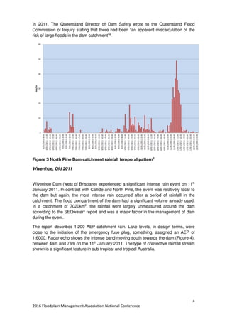
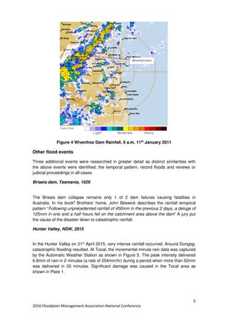
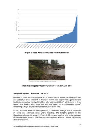
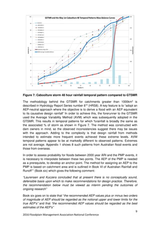
This document discusses implications of inconsistencies between the expected and actual severity of flooding events for dam safety, floodplain management, and emergency planning. It summarizes research into six flood events where rainfall probabilities did not match flood probabilities. In some cases, dam safety triggers were nearly activated by floods that models predicted should have much lower probabilities. The document explores potential deficiencies in design methodologies, data, and application of methods that could account for these inconsistencies and their implications for underestimating flood risks.
Early warning of glacial lake outburst floods and climate change monitoring i...Global Risk Forum GRFDavos
Christoph HAEMMIG1, Hansrudolf KEUSEN1, Josef HESS2
1Geotest AG, Switzerland; 2Federal Office for the Environment, Executive Director LAINAT, Switzerland;
EOPS_May_2_2016,
Spring air temperatures are higher - it has been sunny and dry. The snowpack is quickly disappearing as temperatures are up to 7 °F warmer at higher elevations. Snowmelt-fed rivers are running very high. How does this affect water quality in Puget Sound? A strong spring phytoplankton bloom extends across Puget Sound and the Strait of Juan de Fuca. Water temperatures are still higher than normal and jellyfish are already numerous in southern inlets. The high biological activity is causing organic material to drift at the surface and wash onto beaches. Do you know how fast a Sand Star can move?
Ecology Publication No. 16-03-073
These are the slides from our May 23, 2014 Friday Forum workshop entitled 'Predicting and projecting the frequency of extreme marine events on time scales of days to decades with a focus on coastal flooding' led by Dalhousie University Professor Keith Thompson.
The marine environment presents humankind with great economic opportunity but also major risks. It is a dangerous place to extract resources, and a particularly challenging environment for transportation, construction and human development. Our relationship with the marine environment is evolving due to climate change (e.g., global sea level rise, reduced pack ice in the Northwest Passage) and also shifts in economic and societal use (e.g., deep ocean drilling, marine recreational activities). In 2012 a new national network was established to bring together researchers and partners in a multi-sectoral partnership in order to improve Canada’s capabilities in Marine Environmental Observation, Prediction and Response (MEOPAR). In this talk Keith first provided an overview of this new network and then described some of its research, focusing mostly on coastal flooding. He then described how MEOPAR is making extended-range predictions of east coast storm surges, and the probability of coastal flooding, with lead times of hours to about 10 days. He also described a new statistically-based method for estimating the probability of coastal flooding over the next century, taking into account uncertainty in projections of sea level rise and storminess.
Keith Thompson is a Professor at Dalhousie University with a joint appointment in the Department of Oceanography and the Department of Mathematics and Statistics. He holds a Canada Research Chair in Marine Prediction and Environmental Statistics. His research interests include ocean and shelf modelling, data assimilation, sea level variability, the analysis of extremes. New interests include the Madden Julian Oscillation and the Kuroshio Extension current system. He is presently a theme lead for the Marine Environmental Observation Prediction and Response (MEOPAR) network, a large national network established recently to help Canada respond more effectively to marine emergencies and change.
Tulloch Reservoir and the Drought of 2012-201?gfalken
This document summarizes a presentation given by Tri-Dam Project on the Tulloch Reservoir and ongoing drought conditions. It provides background on Tri-Dam Project and how it manages four reservoirs, including Tulloch Reservoir. It describes the current drought conditions and low water levels at New Melones Reservoir. It notes regulatory requirements for fish flows that could require draining Tulloch Reservoir and shortfalls in meeting those requirements with current storage. It outlines potential reservoir operations and water levels over the next year depending on rainfall. It closes by discussing next steps in finalizing Tulloch Reservoir's operating schedule and continued engagement with local communities and agencies.
Presentation by Ellis Penning, Koen Berends, Jasper Dijkstra and Uwe Best (Deltares), at the Webinar Quantifying vegetation dynamics for designing and managing Nature-based Solutions, during Delft Software Days - Edition 2021. Tuesday, 9 November 2021.
1) Aerial photography on April 21, 2014 showed blooms in Whidbey Basin and isolated bays, with otherwise clear water. Sediment-rich water was entering Puget Sound from the Stillaguamish River after the Oso mudslide. Debris lines were observed in Hood Canal and North Sound. Multiple oil sheens were seen in the Lake Washington Ship Canal.
2) Physical conditions in Puget Sound were developing into colder, saltier conditions throughout the region. Dissolved oxygen levels were lower in Whidbey Basin, Central Sound, and South Sound but higher in Hood Canal.
3) Upwelling conditions off the Washington coast in mid-April stimulated a spring phytop
1. ESI provided a conceptual model of the London Basin aquifer for the Environment Agency, advancing understanding of its hydrogeology and addressing issues like abstraction sustainability.
2. ESI served as an expert witness for a petrol retailer, advising on risks from a diesel spill and demonstrating remediation addressed contamination risks.
3. ESI assessed the impact of over 30 groundwater abstractions on key streams for Severn Trent Water, quantifying low flow issues to identify remedial options.
4. ESI minimised environmental and reputational liabilities for a company from a 40,000 liter diesel leak by rapidly investigating and containing the spill.
Warmer and sunnier days result in higher than normal river flows from the Skagit and Nisqually. Biological activity in the water column is high. Abundant organic surface debris in Hood Canal, Padilla Bay, and many Inlets. Red-brown blooms in South Sound, Discovery Bay, and regions of Bellingham Bay. Different blooms in Skagit Bay, Padilla Bay, and Sinclair Inlet. Jelly fish are numerous in all southernmost South Sound Bays. Hood Canal remains cold but Puget Sound-wide temperatures are now warmer and less salty. Data from the Victoria Clipper and our sampling in the Strait provides important information on water exchange with the ocean.
EOPS_December_30_2015,
The year 2015 in pictures: Jellyfish patches persisted through the entire year in response to the exceptionally warm water caused by the Blob. Sediment loads are high as snow melts fast in the winter of 2015. Unexpected phytoplankton species occur in some bays in spring. Noctiluca, jellyfish and macro-algae appear in high numbers when rivers drop to record-low flows in early summer. Low river flows slow the renewal of in Puget Sound throughout summer and fall and jellyfish patches reach record highs.
Ecology Publication No. 15-03-080
The aerial photos from March 25, 2013 show:
- Strong jellyfish aggregations in southern inlets of Puget Sound.
- A large red-orange-brown plankton bloom in Hood Canal.
- Satellite images confirm the Hood Canal bloom and sediment plume from the Elwha River.
- Water temperatures are rising in Puget Sound while dissolved oxygen levels are generally decreasing with higher salinities.
Warm air and water temperatures and offshore winds have persisted since fall. Numerous and sizable jelly fish patches are still present in southern inlets of Puget Sound. Coastal waters were colored in shades of gray to brown by sediment and humic substances. Phytoplankton blooms were restricted to the surf zone. We were treated to artful views of meandering sloughs and gullies on exposed mud flats during low tide in Willapa Bay, interspersed with the geometry of shellfish management. Brown pelicans: a story of recovery.
Climate change and its impact on the fisheries in Lake Kivu, East AfricaInnspub Net
Climate change, its variability, and its impact on fish catch in Lake Kivu were verified from the analysis of climate variables and fisheries statistics. The results show qualitative and quantitative disturbances in the variation of rainfall, the significant increase in temperature of 1.57°C, 0.63°C, and 0.66°C at Kamembe, Gisenyi, and Lwiro, respectively around Lake Kivu watershed. The relative humidity decreased significantly by 4.5% and 7% at Gisenyi and Kamembe, respectively; the wind speed decreased by 3 m/s. These changes resulted in a decrease of 0.58 m in the water level of the lake, followed by periods of declines in catches of Limnothrissa modern, the major lake’s commercial fish. Predictions show a decline in Catch per Unit Effort of 2.92 kg for an approximate reduction
of 0.01 m water level by 2025. Strategic policies should be made and adaptation measures are taken to prevent climate change, in order to conserve the aquatic resources and avoid advert conditions in the fisheries sector of Lake Kivu.
EOPS_April_6_2016,
Despite warmer air temperatures, normal snowpack in the mountains suggest that summer freshwater flows into Puget Sound might be higher than last year. As of April, the spring plankton bloom has extended across Central and South Puget Sound. Ferry data shows chlorophyll increasing after March 25 and expanding across the area. With water temperatures above normal as a carry-over from 2015, jellyfish patches are numerous in inlets of South Sound and in Sinclair Inlet, unusual for this time of year. Check out the tiny burrowing ostracods as well as our Washington Conservation Corps Intern analyzing seawater oxygen.
Ecology Publication No. 16-03-072
Lakeshore Hydrant Services provides inspections and monitoring of non-municipal water sources for firefighting, such as cisterns, ponds, and lakes, to ensure they comply with NFPA standards. They use remote-controlled boats with sonar and cameras to map and inspect bodies of water, documenting water levels, shorelines, and the condition of water intakes. Their detailed inspection and documentation program helps identify issues and monitor changes over time to restore water sources for fire protection purposes. As more rural properties rely on these alternative water sources, their third-party inspection services are being utilized by municipalities and private landowners.
The weather changed from cool, cloudy and southerlies, to sunny warm conditions and light northerly winds on Mother’s Day. At the water surface, blooms and large debris lines occur in Bellingham, Padilla, and Samish Bays, Hood Canal, East Sound, and the Straits, as well as the finger inlets of South Sound. Large amounts of sediment-laden water from Port Susan are flowing into Central Basin. Turquoise water mixing to the surface in places around the San Juan Islands. After some trouble-shooting of the hardware and communication system, we will resume collecting Victoria Clipper data next week. Meet Eyes Under Puget Sound: Sediment Monitoring Program at Ecology.
This document summarizes information about floods in northeast India, including types of floods, causes, flood management approaches, and case studies. It discusses riverine floods, flash floods, and dam-induced floods. Differences between riverine and urban/flash flooding are highlighted. Flood early warning systems used in Assam are described, including hydrological modeling, weather prediction, and embankment monitoring. Case studies using hydraulic models in Assam rivers are mentioned. The document concludes with photos showing field applications and impacts of flood management strategies.
River flows are above normal and air temperatures are increasing slowly. The spring phytoplankton bloom is slow to develop with visible blooms limited to smaller bays such as Sequim and Bellingham Bays. Noctiluca observed in East Sound on Orcas Island, coinciding with high numbers of jellyfish. Debris lines are mostly confined to Hood Canal. Pockets of colder water observed in Central Sound and Hood Canal, likely from the colder, saltier conditions that developed during the winter in the northern regions. Oxygen is variable yet close to expected ranges. Sizable oil sheens were sighted in Gig Harbor and Carr Inlet.
The document summarizes observations from aerial surveys and monitoring efforts of the Puget Sound region from May 14, 2012. It notes strong algal blooms throughout the South Sound and Central Basin as well as abundant debris. Dissolved oxygen levels had decreased in the last two weeks despite high algae production. It also describes King County's long-term marine phytoplankton monitoring program, which samples at three locations to assess water quality and understand dynamics of Puget Sound phytoplankton. Finally, it shows common chain-forming diatom genera that typically dominate the spring bloom in Puget Sound.
Dannelle Belhateche, PE, Senior Assistant Director for the City of Houston's Department of Public Works and Engineering discusses lessons learned after Hurricane Ike where sustained power outages affected the drinking water quality and more.
Sun and high air temperatures warrant en route ozone measurements for model validations. A furry visitor takes a rest on the float plane. Spotlight on our pilot, Joe Leatherman. High river flows lead to striking fronts of turquoise-colored water carrying glacial flour in many northeastern regions. Satellite and aerial images show widespread phytoplankton blooms in Whidbey Basin, Hood Canal, South Puget Sound, and West Bay of Orcas Island. Numerous large debris patches in Hood Canal, Central Sound, and South Sound Inlets. After two years of colder temperatures and higher oxygen, Puget Sound waters are returning to expected or lower dissolved oxygen levels.
EOPS_June_5_2017,
Cooler and wetter conditions early in 2017 have set the stage for a favorable supply of freshwater. River flows are all above normal due to melting of the abundant snowpack from warmer May air temperatures. This is creating significantly fresher conditions in Puget Sound surface waters. Algae blooms are limited to some yellow-green blooms growing in bays near the Kitsap Peninsula and blooms near estuaries of the Skagit, Stillaguamish, and Puyallup Rivers. Red blooms are present in rivers feeding into Willapa Bay. Also see what is “blooming” in the sediments of Puget Sound.
Ecology Publication No. 17-03-070
Enbridge provides a summary of its liability insurance coverage for environmental damage from pipeline releases. The coverage amounts are consistent with industry standards but are not disclosed. Enbridge reviews its pipelines for risks from factors like erosion but does not detail its mitigation strategies. In the event of a spill contaminating aquifers, Enbridge would develop a remediation plan with regulators, but the potential spill size depends on many incident-specific variables.
EOPS_June_27_2016,
Record-breaking warmer and fresher water in Puget Sound. May-June conditions are more unusual than last year. Recent rain brought river flows close to normal but water exchange in Puget Sound remains weak due to low Fraser River flow. Phytoplankton blooms and organic material are visible in some areas of Central and South Sound but not in others. Noctiluca, while absent in Central Basin, was reported in unusual places. Jelly fish occur only in some south sound bays. Follow our BEACH program kick off, discover the Stinkworm, and find good underwater visibility for diving.
Ecology Publication No. 16-03-074
The document discusses the national and regional direction of stormwater programs. It summarizes recent EPA activities including a National Research Council report recommending that stormwater programs regulate flow rather than pollutants. The document also outlines EPA's plan to develop consistent stormwater regulations through rulemaking, including establishing post-construction requirements and expanding coverage to additional discharges. Region 4 expects future MS4 permits to include clearer, more specific, and enforceable requirements.
Este documento discute varias ecuaciones para calcular la energía específica, la cantidad de movimiento y la pérdida de carga en canales y tuberías. Presenta las ecuaciones de Manning, Chezy y Bazin para calcular la velocidad del agua basada en la pendiente, el radio hidráulico y los coeficientes de fricción. También explica cómo la energía específica depende del tirante del agua y cómo las ecuaciones de Manning, Chezy y Bazin se pueden usar para resolver problemas de flujo de agua.
La película Pixels trata de un niño que le encanta jugar videojuegos. De adulto, las criaturas de los videojuegos salen de un portal hacia la Tierra para destruirla. El reparto incluye a Adam Sandler y Kevin James. La crítica elogia que la película, relacionada con videojuegos, es entretenida y realista, y la recomienda para personas a las que les gustan los videojuegos y las consolas.
La novela Zapatillas Rojas sigue la historia de cuatro amigas inseparables - Lucía, Frida, Bea y Marta - mientras pasan por una etapa intensa en sus vidas y ponen a prueba su amistad. La autora Ana Punset crea personajes distintos pero unidos por su amor por la una a la otra. A pesar de los desafíos de la vida, como Marta mudándose a Berlín, las amigas lucharán por mantenerse cerca la una de la otra.
Dokumen tersebut membahas tentang tujuan dan kompetensi dasar mata kuliah kewirausahaan. Mata kuliah ini bertujuan untuk membentuk mahasiswa memiliki semangat berwirausaha dan jiwa bisnis serta memahami teknik pendirian usaha."
El documento argumenta que la obediencia y la fe deben preceder a las bendiciones de Dios. Indica que en la Biblia, Dios le pidió a la gente que hiciera algo primero antes de ayudarles, como cuando le dijo a Moisés que golpeara la piedra para que brotara el agua. También dice que si damos un paso de fe obedeciendo la voluntad de Dios, Él nos ayudará y nos dará más.
The document discusses a holistic assessment of dam operations in Southeast Queensland that balanced flood mitigation and water supply functions. It describes developing an integrated assessment methodology to evaluate costs and benefits of different dam operation strategies. The methodology considered factors like flood damage, infrastructure costs, and water security. The study found that modifying operations to reduce one risk increased the other, with minimal overall benefit. Maintaining a balanced approach between flood mitigation and water storage was concluded to be best.
The document provides a damage assessment report for St. Lucia following Hurricane Tomas in 2010. It summarizes the extensive flooding and damage to river systems caused by over 24 inches of rainfall from the hurricane. An engineering team was commissioned to assess damage to key sectors and develop recommendations. The team proposed 5 projects focusing on immediate rehabilitation of rivers and drainage, river training, hydrological modeling, early flood warning systems, and a watershed management program. The projects aim to mitigate future flood risks, inform planning, and provide employment through labor-intensive activities.
Impact of Sea Level Rise from Storm Surge USADag Lohmann
We're quantifying the impact that a 30cm sea level rise has on losses from hurricanes for each individual location in the USA. We're also looking at losses from a hypothetical sea level in the year 1900. Summaries are shown by state and selected maps.
Summary of results: Based on current conditions of exposure (e.g. buildings and other economic assets) we have an annual average loss of about $5 Billion from our simulations. Given the sea level in 1900 that loss would go to $4 Billion. Current projections of sea level rise vary widely, but most have us exceed 30cm between 2040 and 2080. Some go much higher (many meters), while the most optimistic ones are around 30cm at the end of the century. Given the same exposure, same sea defenses, and same hurricanes, losses would go up to an average of $6.9 Billion / year (called the average annual loss or AAL).
IRJET- Flood Mitigation & Management for Godavari River at Nashik City by SWM...IRJET Journal
This document summarizes a study on flood mitigation and management for the Godavari River in Nashik City, India using SWMM5 and QGIS modeling tools. Urbanization has increased flooding in the city by converting pervious land to impervious surfaces, reducing infiltration and increasing surface runoff. The study aims to develop flood exposure maps, simulate long-term water runoff quantity and quality, identify sub-catchments and impervious/pervious areas. SWMM5 is used to model rain barrels, rain gardens, permeable pavements and infiltration trenches to mitigate flooding. QGIS identifies low-lying areas suitable for stormwater collection. Land use/cover is classified and slope is derived from digital elevation data to determine
This document summarizes the findings of the National Flood Resilience Review in the UK. The review was prompted by extreme flooding events in recent years. Key findings include:
1) New extreme rainfall scenarios were developed to stress test flood risk models and maps. This revealed infrastructure at risk of flooding.
2) Temporary flood defenses could help protect critical local infrastructure, and a pilot study assessed their potential use.
3) Next steps include improving infrastructure resilience, response plans, innovative flood defenses, and long-term modeling improvements. Better communication of flood risks is also recommended.
The document describes the development of a state-of-the-art flood early warning system for Oakey Township in Queensland, Australia. The system integrates rainfall predictions, real-time gauge data collection, hydrological modelling, and digital flood mapping. It includes installation of stream and rainfall gauges connected via telemetry, as well as paper-based backup systems and flood wardens. The system aims to provide accurate and timely flood information to emergency services and residents to help with evacuation and emergency response decisions.
This document provides an overview of floods, including their causes, types, effects, and management. It discusses intrinsic and extrinsic factors that can cause flooding when thresholds are exceeded. The main causes of flooding are meteorological, hydrological, and anthropogenic factors like urbanization and deforestation. Common flood types are river floods, flash floods, coastal floods, and urban floods. Estimating floods involves past records, the Rational Method, and flood frequency studies. Design floods are selected based on their return period and probability. Prone areas in India are mapped. Flood management strategies include building on raised platforms, afforestation, forecasting, and controlling water flow with dams.
Developing a Model to Validate the Use of Landsat and MODIS Data to Monitor C...daileya
This document describes developing a model to analyze Landsat and MODIS data to monitor coastal wetland areas in Louisiana for persistent saltwater intrusion. The model combines data from various sources, including USGS monitoring stations and Landsat imagery, to identify relationships between salinity, flooding, and vegetation changes. It extracts relevant data for selected dates and locations to produce a database for analyzing how wetlands respond to physical changes. Results show the procedure fulfills requirements for sorting multi-source data and aiding interpretation of remote sensing products for coastal wetland monitoring and restoration.
DHI UK & Ireland Symposium 2017 ProgrammeStephen Flood
DATA-LED DECISION MAKING IN A CHANGING WORLD
Knowledge sharing for water and environmental professionals
DHI UK & Ireland is very pleased to invite you to our annual Symposium 2017.
REGISTRATION
www.dhi-symposium.uk
IMPORTANT DATES
Reception: 26th June 2017 (evening)
Symposium day: 27th June 2017
FEES
Participation in the event is free of charge, including:
- drinks reception and symposium dinner on the 26th June
- lunch and attendance at the Symposium on 27th June
LOCATION AND VENUE
The Moat House, Acton Trussell, Stafford, Staffordshire, ST17 0RJ, UK.
Please visit www.moathouse.co.uk
This free event is your opportunity to learn more about the varied applications of our modelling software, and our complementary technologies, through client-led presentations. The Symposium provides an excellent opportunity to meet DHI experts, as well as your contemporaries from consultancy, academia, regulatory authorities and research organisations.
We will be starting this year's event with drinks reception and conference dinner, hosted by DHI UK & Ireland, on the evening of Monday 26th June 2017. We encourage everyone to arrive on the 26th to relax with a drink, good food, some informal networking, and news about our forthcoming MIKE 2017 release.
The main event will start at 9:00am on the Tuesday 27th June 2017. This day will be your opportunity to tell everyone how you have been using MIKE software over the past 12-months, share newly acquired knowledge and innovations, learn how we use our software, and network with your peers. Lunch will be provided, and the day will finish around 4:30pm to give you time to travel home. You are more than welcome to stay on later if you wish to meet with us face to face.
Dr. Cynthia Rosenzweig, Senior Research Scientist, NASA Goddard Institute for Space Studies Senior Research Scientist, Earth Institute at Columbia University Co-Chair Mayor Bloomberg’s Climate Change Commission Co-Director Urban Climate Change Research Network (UCCRN); National Institute for Coastal & Harbor Infrastructure, John F. Kennedy Center, Boston, Nov. 12, 2013: "The Triple Threat of Rising Sea Levels, Extreme Storms and Aging Infrastructure: Coastal Community Responses and The Federal Role" See http://www.nichiusa.org or http://www.nichi.us
06 April Lewisvile Dam Press Conference RemarksRandall Cephus
Public safety is the top priority for Lewisville Lake Dam. While some issues are known, the dam is not at risk of failing. Both short and long-term plans are in place to maintain dam safety. Repairs are underway to address recent concerns discovered through annual inspections and monitoring. A $10 million contract was awarded to fix issues from 2015 flooding. Long-term risk reduction measures currently in development will begin construction in 2018, earlier than planned. The Fort Worth District is committed to transparency and has invited officials to witness ongoing repairs.
Sea level rise and storm surge tools and datasets supporting Municipal Resili...GrowSmart Maine
Why plan for growth and change, when it seems so much easier to simply react?
When there is a distinct and shared vision for your community - when residents, businesses and local government anticipate a sustainable town with cohesive and thriving neighborhoods - you have the power to conserve your beautiful natural spaces, enhance your existing downtown or Main Street, enable rural areas to be productive and prosperous, and save money through efficient use of existing infrastructure.
This is the dollars and sense of smart growth.
Success is clearly visible in Maine, from the creation of a community-built senior housing complex and health center in Fort Fairfield to conservation easements creating Forever Farms to Rockland's revitalized downtown. Communities have options. We have the power to manage our own responses to growth and change.
After all, “Planning is a process of choosing among those many options. If we do not choose to plan, then we choose to have others plan for us.” - Richard I. Winwood
And in the end, this means that our children and their children will choose to make Maine home and our economy will provide the opportunities to do so.
The Summit offers you a wonderful opportunity to be a part of the transformative change in Maine that we’ve seen these gatherings produce. We encourage you to consider the value of being actively involved in growing Maine’s economy and protecting the reasons we choose to live here.
Climate change preparedness and engagement in southwest florida 10 21-19David Silverberg
This document summarizes a presentation on climate change preparedness and community engagement given to the Collier County Democratic Club. It discusses concerns about sea level rise, increased storminess, and heavy precipitation in coastal Southwest Florida. Projections show rising sea levels could lead to inundation, coastal erosion, and more frequent nuisance flooding. Warmer ocean temperatures are also leading to more intense hurricanes that are larger and move more slowly. The presentation outlines efforts in Collier County to understand vulnerability and plan for adaptation through projects with NOAA and the Florida Department of Environmental Protection. Regional collaboration between counties is also discussed as important for climate resilience planning.
This document describes the calibration of the SBEACH model to simulate storm-induced beach changes in Bay County, Florida. The model was calibrated using beach profile surveys from before and after Hurricane Ivan in 2004. Hydrographic, wind, and wave data from Ivan were input to the 2D storm surge model to calculate storm tides. Measured storm tide levels along the panhandle were also used. The calibrated SBEACH model was then applied to develop erosion profiles for the Bay County shoreline for 15-year and 25-year storm events.
Projected Climate Change Impacts for Rhode Island’s Coast: A Summary of the S...riseagrant
Learn the facts about climate change in Rhode Island, existing impacts, and near-term projections presented by Austin Becker, URI College of Environmental Life Sciences
Preparing New Zealand for rising seas: Certainty and UncertaintyBlair Mayston
This document discusses preparing for rising sea levels in New Zealand. It provides the following key points:
1. Sea levels are rising and will continue to do so for centuries, increasing risks from coastal flooding, erosion, and rising groundwater. However, the exact impacts are uncertain as they depend on local conditions.
2. Low-lying coastal cities and towns are especially vulnerable. Over 9,000 homes in New Zealand lie less than 50cm above spring high tide levels and will be at increasing risk.
3. Central government guidance for planning and adaptation is needed but should be improved. Coastal hazard assessments and zoning must have transparent, scientifically rigorous methods and involve community engagement.
The document provides an overview of the 2007 flooding in Gloucestershire, England. It summarizes the responses of various organizations:
- Gloucestershire experienced one of its worst floods in history in July 2007 when over two months of rain fell in 14 hours. Over 350,000 people were affected by flooding and water shortages.
- The police led the response effort, establishing a command structure to coordinate agencies. Other agencies like the fire department conducted search and rescue, protected infrastructure, and distributed water. The military also assisted with rescue, flood defenses, water distribution, and logistics.
- Severn Trent Water worked to restore water access, deploying over 1,400 water bowsers and distributing millions of bottles
Flooding is the most common natural hazard in Collin County, Texas. It occurs when heavy rainfall causes creeks and streams to overflow their banks, especially in low-lying areas near waterways. While flooding can happen quickly during storms, it typically lasts for only a few days. The areas at highest risk are located within the 100-year or 500-year floodplains near creeks. Relatively few structures are at risk, as Collin County restricts building in flood-prone locations. However, some facilities like an outdoor science center and an elementary school near Plano have experienced flooding issues. Homeless populations living in parks are also vulnerable if flash flooding occurs.
2017 MAIREINFRA Conference, Seoul, South Korea, July 19-21.Waheed Uddin
Keynote Lecture, Waheed Uddin:
Disaster Resilience Management and Flood Hazard Assessment of Infrastructure Using Computational Modeling and Geospatial Risk Mapping
2017 MAIREINFRA Conference, Seoul, South Korea, July 19-21.
James Stuart Full paper(1)
1. 1
2016 Floodplain Management Association National Conference
100 OR 10000 YEAR FLOOD, WHO KNOWS?
IMPLICATIONS FOR DAM, FLOODPLAIN AND EMERGENCY
MANAGEMENT.
James Stuart,
Flood and Streamflow Manager, SunWater.
E-mail: James.stuart@sunwater.com.au
Rob Keogh,
Manager, Service Delivery, Bulk water, SunWater
E-mail: Rob.Keogh@sunwater.com.au
Lucas Hughes,
Student Engineer, SunWater.
E-mail: Lucas.hughes@sunwater.com.au
Acknowledgements: Bureau of Meteorology, Richland County Emergency Services,
NASA.
Background
Many community planning and community safety activities are based on hydrologic
design methodologies. These include but are not limited to:
• Land use planning, which utilises design flood levels associated with annual
exceedance probability (AEP), e.g. the community is protected from loss by
excluding residential development in areas that are affected by a flood risk
frequency of greater than say, 1%.
• The construction of flood risk protection works such as levees, also designed to
withstand a certain flood frequency;
• Safety assessment of major dams, based on societal risk.
• Emergency planning and considering the level of immunity afforded to critical
infrastructure, such as communication systems and evacuation routes.
The aim of the methodologies is AEP neutrality, that is, a rainfall event of a particular
AEP produces a flood event of a similar AEP.
SunWater has undertaken research into a number of events where there has been a
significant inconsistency between the AEP of the rainfall event and the apparent AEP
of the associated flood. In two cases, design dam safety measures were close to
automatic triggers. This inconsistency has significant implications for communities
regarding their level of exposure to flood risk in that it may be far higher than is
understood. The consequences of understated risk could lead, in the event, to greater
damage, the failure of emergency plans and, most importantly, potential loss of life.
SunWater has identified that there are a number of possible deficiencies in design
methodologies, and the understanding and application of those methods by
practitioners.
2. 2
2016 Floodplain Management Association National Conference
This paper explores these possible deficiencies including:
• The appropriateness of assumptions and data sets used in the development of
design methodologies and errors potentially introduced. This includes the
limitations of historic storm events used to develop Probable Maximum
Precipitation (PMP) estimations and their representation of intensity.
• The application of methodologies by practitioners in a prescriptive manner ,
without considering appropriate sensitivity analysis around issues such as the
uncertainty of the AEP of the PMP;
Callide Dam Flood of Record
The trigger for the investigation on which this paper is based was the significant rainfall
event in 2015 associated with Tropical Cyclone Marcia (TC Marcia) in the Callide
Valley. TC Marcia passed over Callide and Kroombit Dam catchments (Figure 1)
resulting in record floods in both.
Figure 1 Callide and Kroombit Dams (Rain gauges in blue)
The critical design storm duration is assessed as 6 hours. The event lasted around 24
hours over the catchment although some point locations received rain for a total of 48
hours. Operational and post event modelling was complicated by the highest rating
curve ordinate having been exceeded, in the event, by over 2 metres and the need to
use relatively low storage parameters. The catchment rainfall temporal pattern is
shown in Figure 2.
SunWater assessed the rainfall as having around a 1:200 – 1:500 Annual Exceedance
Probability (AEP). An independent review reached the same conclusion1
. An
3. 3
2016 Floodplain Management Association National Conference
examination of the design hydrology report2
showed the peak lake level had an AEP of
the order of 1:4000. This inconsistency presents a significant problem. The 200-500
year rainfall resulted in lake levels that were 2 cm below automatic emergency
structural preservation measures being triggered.
An investigation was initiated through the SunWater Portfolio Risk Assessment process
in 2015 into this inconsistency and its implications. This is ongoing at the time of writing
but has focused on researching other similar rainfall events, design rainfall methods
and their implementation.
Figure 2 Callide Dam Catchment Rainfall Temporal Pattern
Other record dam flood events
The inconsistency between the probability of rainfall and consequential lake level was
not unique to the TC Marcia event; it was also observed in the following two events.
North Pine Dam, Qld, 2011
North Pine Dam (north of Brisbane) experienced a similar event on 11th
January 2011.
Preliminary post event analysis in the operational report3
estimated that the event was
of the order of 1:9000 AEP in terms of lake level with an inconsistent rainfall estimation
of 200 years AEP.
Four similarities with the Callide experience were obvious: the catchment area, the
rainfall temporal pattern with an intense period towards the end of the event (see
Figure 3), both dams having gates and like Callide, modelling led to underestimation of
volume and peak flow despite the low nature of loss rates.
4. 4
2016 Floodplain Management Association National Conference
In 2011, The Queensland Director of Dam Safety wrote to the Queensland Flood
Commission of Inquiry stating that there had been “an apparent miscalculation of the
risk of large floods in the dam catchment”4
.
Figure 3 North Pine Dam catchment rainfall temporal pattern3
Wivenhoe, Qld 2011
Wivenhoe Dam (west of Brisbane) experienced a significant intense rain event on 11th
January 2011. In contrast with Callide and North Pine, the event was relatively local to
the dam but again, the most intense rain occurred after a period of rainfall in the
catchment. The flood compartment of the dam had a significant volume already used.
In a catchment of 7020km2
, the rainfall went largely unmeasured around the dam
according to the SEQwater5
report and was a major factor in the management of dam
during the event.
The report describes 1:200 AEP catchment rain. Lake levels, in design terms, were
close to the initiation of the emergency fuse plug, something, assigned an AEP of
1:6000. Radar echo shows the intense band moving south towards the dam (Figure 4),
between 4am and 7am on the 11th
January 2011. The type of convective rainfall stream
shown is a significant feature in sub-tropical and tropical Australia.
5. 5
2016 Floodplain Management Association National Conference
Figure 4 Wivenhoe Dam Rainfall, 6 a.m. 11th
January 2011
Other flood events
Three additional events were researched in greater detail as distinct similarities with
the above events were identified; the temporal pattern, record floods and reviews or
judicial proceedings in all cases.
Briseis dam, Tasmania, 1929
The Briseis dam collapse remains only 1 of 2 dam failures causing fatalities in
Australia. In his book6
Brothers’ home, John Beswick describes the rainfall temporal
pattern “Following unprecedented rainfall of 450mm in the previous 2 days, a deluge of
125mm in one and a half hours fell on the catchment area above the dam” A jury put
the cause of the disaster down to catastrophic rainfall.
Hunter Valley, NSW, 2015
In the Hunter Valley on 21st
April 2015, very intense rainfall occurred. Around Dungog,
catastrophic flooding resulted. At Tocal, the incremental minute rain data was captured
by the Automatic Weather Station as shown in Figure 5. The peak intensity delivered
6.8mm of rain in 2 minutes (a rate of 204mm/hr) during a period when more than 52mm
was delivered in 20 minutes. Significant damage was caused in the Tocal area as
shown in Plate 1.
6. 6
2016 Floodplain Management Association National Conference
Figure 5: Tocal AWS accumulated one minute rainfall
Plate 1: Damage to infrastructure near Tocal, 21st
April 2015
Deception Bay and Caboolture, Qld, 2015
On May 1st
2015, an east coast low led to intense rainfall around the Deception Bay
and Caboolture areas just north of Brisbane. 350mm was recorded as a general event
total in the immediate vicinity of the Hays Inlet catchment (80km2
) with 240mm in three
hours7
. The flooding along Hays Inlet was the subject of an independent review7
concerning a major rail project under construction at the time.
In the Caboolture River catchment (355km2
), a catchment average total of 264mm in
36 hours was estimated using URBS modelling. The temporal pattern for the
Caboolture catchment is shown in Figure 6. 87 mm was received prior to the increase
of intensity above 5mm/hr. Peak intensity measured was 4mm in 1 minute (240mm/hr)
at several locations.
7. 7
2016 Floodplain Management Association National Conference
Figure 6: Caboolture River catchment temporal pattern, 2015 event
Similarities
A number of similarities are apparent from the above six events:
1. All catchment temporal patterns have a more intense period towards the end of
the event when storages already had a significant volume above FSL or
catchments were already wet.
2. Intense rainfall cells achieved levels at Callide, North Pine and Wivenhoe at
which dam safety was becoming the overriding priority.
3. In two cases discussed, modelling predictions were unable to keep pace with
the rate of rise. Adopted modelling parameters were different from those used
in calibration events.
4. All events resulted in flooding of property,
5. Records floods at Callide and Wivenhoe are not the largest catchment floods
known to have occurred prior to construction.
6. All events resulted in reviews or judicial proceedings
Based on these similarities, research for contributing factors was broadly grouped into
three areas; Design rainfall methods including data inputs; application of those
methods and lastly climate change.
Design rainfall methods and associated data inputs
Design methods used for the range of frequencies available to Engineers in Australia
are summarised in Table 1. The focus for this study is in the range 2000 years to PMP
as it is this range in which SunWater has a particular interest as a dam owner and
operator.
8. 8
2016 Floodplain Management Association National Conference
Table 1: Design methods summary (modified from Aurecon8)
There will undoubtedly be discussion about whether it is appropriate to compare burst
theoretical events with actual, observed events. This is the first issue. If we are unable
to compare design methods for levees and dams with those through which they need
to survive, this suggests, as an industry, we have a problem. Effectively, what’s being
inferred in such discussion is ‘it’s not designed for such a situation’. If it’s not
appropriate, how can we properly operate and manage our assets with storms that
don’t fit the design methods? There will always be variability in flows for any estimated
probability. The issue is one of acceptable variability. Is a 9000 year design level from
200 year rainfall acceptable variability?
Informal conversations during the preparation of this paper have suggested that
analysis should solely consider the most intense part. To discard the rain in the lead up
period is, in the view of the writers, not credible.
The issue is summarised in Figure 7. At 355km2
, the Caboolture catchment fits into the
GSDM9
and theoretically requires comparison to a 1 - 6 hour storm. As the event was
around 48 hours, this is not possible. Comparing the storm pattern with the GTSMR
derived patterns for larger areas is not really appropriate but has been carried out to
demonstrate the significant variability of actual storms against derived temporal
patterns.
Average
Recurrance
Interval (ARI)
ARI ARI
2 to 100 200 to 2000
2000 years to
PMP
years (Large) years (Rare) (Extreme)
1
BoM (2013)
design rainfalls
CRC-Forge (2005)
Interpolated
using procedures
6 ARF ARF
Nathan &
Weinmann,
24
ARR Project 2
(2013)
ARR Project 2
(2013)
48
72
96
120
168
Extrapolated CRC-
Forge (2005)
Extrapolated
GTSMR (2003)
Burst Duration
(h)
PMP (Extreme)
Generalised
Short Duration
Method
(GSDM) (2003)
Generalised
Tropical Storm
Method
Revised
(GSTMR) (2003)
9. 9
2016 Floodplain Management Association National Conference
Figure 7: Caboolture storm 48 hour rainfall temporal pattern compared to GTSMR
The methodology behind the GTSMR for catchments greater than 1000km2
is
described in Hydrology Report Series number 810
(HRS8). A key feature is to “adopt an
AEP-neutral approach where the objective is to derive a flood with an AEP equivalent
to its causative design rainfall” In order to achieve this, the forerunner to the GTSMR
used the Average Variability Method (AVM) which was subsequently adopted in the
GTSMR. This results in temporal patterns for which %rainfall is broadly the same as
the associated % of storm as shown in Figure 7. The method was constructed with
dam owners in mind, so the observed inconsistencies suggest there may be issues
with the approach. Adding to the complexity is that design rainfall from methods
intended to estimate more frequent events achieved these extreme levels. AVM
temporal patterns appear to be at markedly different to observed patterns. Extremes
are not average. Appendix 1 shows 8 such patterns from Australian flood events and
those from overseas.
In order to assess probability for floods between 2000 year ARI and the PMP events, it
is necessary to interpolate between these two points. The AEP of the PMP is needed
as a prerequisite, to develop an anchor point. The method for assigning an AEP to the
PMP is based on catchment area and is outlined in Book VI of Australian Rainfall and
Runoff11
(Book six) which gives the following comment:
“Laurensen and Kuczera concluded that at present there is no conceptually sound,
defensible basis upon which to make recommendations for design practice. Therefore,
the recommendation below must be viewed as interim pending the outcomes of
ongoing research”
Book six goes on to state that “the recommended AEP values plus or minus two orders
of magnitude of AEP should be regarded as the notional upper and lower limits for the
true AEP’s” and that “the recommended AEP values should be regarded as the best
estimates of the AEP’s”
10. 10
2016 Floodplain Management Association National Conference
As such, this is likely to be a significant contributor to the observed inconsistencies as a
small change in the AEP can alter the frequency of any flood with an AEP less frequent
than 1 in 2000, as shown in Figure 8. The effects are summed up by Nathan et al12
;
“Changes in the AEP of the PMP by an order of magnitude or more can markedly alter
the estimated risk of infrastructure failure due to flood loading; in some cases
differences of this magnitude may alter the decision on whether or not to undertake
expensive upgrading works.” added to this is the operation of dams with such
uncertainty. Local authorities are planning community safety with the same uncertainty.
Book six also suggests that the coast of Queensland is subject to significantly longer
storm durations than exist elsewhere. On this basis, the lack of a specific zone
(removed in the current revision) may mean dams in this area having underestimated
PMP as methods group the Queensland coast with other areas.
In a final note on methods, GSDM links critical floods on small catchment areas with
short duration rainfall. This assumption would appear invalid based on the events
discussed earlier. The important information for dam owners is related to the rainfall
over the catchment area not the storm duration.
Figure 8: AEP of the PMP uncertainty (source Nathan13 et al, 2015)
Associated data inputs to design methods
GSDM contains data used from the United States and supplemented with data from
five storms in NSW, Victoria and South Australia. The most severe of these, at Dapto in
the Southern Highlands in 1984 delivered PMP estimates of 460mm over 6 hour for an
area of 500km2
.
The lack of considered storms in Queensland presents a potential issue. 460mm over 6
hours in Queensland appears possible as a weather event. Records show 330mm was
recorded at Clermont over 500km2
in 6 hours13
. The danger here is from the input data
location making PMP in tropical areas being a possible event. Taking this a stage
11. 11
2016 Floodplain Management Association National Conference
further, under current methods, this would then be assigned an unlikely probability
based on catchment area. This is potentially a significant contributor to the observed
inconsistencies on small catchments. In addition, the temporal pattern advice has been
conceived from storms in Australia, none of which were from tropical events. Further
investigation is ongoing.
HRS8 details depth data gathered from 122 storms from 92 rain events for use in the
GTSMR. Storms were selected based on passing a threshold generated by the
Intensity Frequency Duration curves from AR&R, 1987. Increments of area (e.g.
500km2
, 2000km2
) were allocated the 10 greatest storm depths in the data base and
then an AVM temporal pattern was allocated from these 10 storms. In many locations
only one station location was available to source three hourly temporal data,
particularly for older storms in the database. Of the 122 storms considered, 37 have no
temporal pattern at all, 19 have one temporal pattern, and 36 have one temporal
pattern for areas less than 5000km2
.
The following comments can be made with regard to this method:
1. Smaller catchment areas are likely to be affected by a reduced availability of
temporal pattern data compared with larger catchments as there is a greater chance
any one of the storms used of only having one temporal pattern. Given the wide
variety of temporal patterns evident throughout a catchment in any storm, this is
unlikely to be representative. Table 2 below lists the top ten 24, 36 and 48 hour
duration storms for 2500km2
and 10000km2
listed in Hydrology Report Series report
number 914
along with the corresponding number of temporal patterns. The effect on
the inconsistencies observed of potentially unrepresentative patterns being used is
difficult to ascertain as we are unable to confirm how representative each temporal
pattern is representative of a greater area.
Table 2: 24, 36 and 48 hour top ten storms and associated number of temporal
patterns used in associated AVM temporal pattern.
24 hour top ten
storms
number of
stations used in
3 hrly temporal
pattern
36 hour top ten
storms
number of
stations used in
3 hrly temporal
pattern
48 hour to ten
storms
stations used
in 3 hrly
temporal
pattern
1893FEB03-1 1 1893FEB03-2 1 1893FEB03-2 1
1898APR03-2 1 1898APR03-2 1 1918JAN24-3 1
1954FEB21-1 1 1954FEB21-2 1 1963APR16-4 1
1955FEB25-2 1 1955FEB25-2 1 1972JAN12-5 1
1956JAN22-2 3 1963APR16-4 1 1974JAN09-3 2
1963APR16-4 1 1974JAN27-2 3 1974JAN27-2 3
1974JAN09-3 2 1974MAR13-4 5 1975DEC10-2 2
1974JAN27-2 3 1978JAN30-5 2 1979JAN06-4 2
1974MAR13-4 5 1982JAN22-2 2 1982JAN22-2 2
1989MAR14-1 2 1989MAR14-2 2 1995FEB28-4 2
24 hour top ten
storms
number of
stations used in
3 hrly temporal
pattern
36 hour top ten
storms
number of
stations used in
3 hrly temporal
pattern
48 hour to ten
storms
stations used
in 3 hrly
temporal
pattern
1893FEB03-1 1 1893FEB03-2 1 1893FEB03-2 1
1898APR03-2 1 1898APR03-2 1 1918JAN25-5 1
1916DEC29-2 5 1954FEB21-2 2 1963APR16-4 1
1954FEB21-2 2 1955FEB25-2 1 1972JAN12-5 1
1955FEB25-2 1 1963APR16-4 1 1974JAN09-3 2
1956JAN22-2 4 1974JAN27-2 8 1974JAN27-2 8
1963APR16-4 1 1974MAR13-4 7 1975DEC10-2 5
1974MAR13-4 7 1982JAN22-2 6 1978JAN30-5 2
1976FEB09-2 1 1989MAR14-2 4 1982JAN22-2 6
1989MAR14-2 4 1995FEB28-4 2 1995FEB28-4 2
2500 km2
10000km2
12. 12
2016 Floodplain Management Association National Conference
2. Three hourly time step temporal patterns used in GTSMR are likely to make design
events less representative of real events because of a poor representation of
intensity. To investigate this, peak intensity point rainfall rates were identified for two
events, Tocal and Caboolture. The resulting average runoff during the period was
calculated over three example areas. E.g., over 100km2
, 4mm in sixty seconds
distributes 6667m3
/s. Each event was then assessed for average contribution over
three hours assuming it were part of a GTSMR temporal pattern. The results are
shown in Table 3 and demonstrate that intensity is not represented well by the
GTSMR. In summary, this compares the reality with how GTSMR would represent
such intensity. Such intense events provide challenges for dam owners and
floodplain managers as they arrive with little warning and have little agreement with
calculated design levels. This concurs with observed events and is identified as a
cause of observed inconsistencies for areas of 1000km2
or more.
Location Date mm Minutes
Runoff
(m3
/s) from
1Km2
Runoff
(m3
/s) from
10Km2
Runoff
(m3
/s) from
100Km2
Tocal (AWS) 21/04/2015 6.8 2 56.6 567 5667
Caboolture (Short St) 1/05/2015 4 1 66.6 666 6667
Tocal (AWS) N/A 6.8 180 0.62 6.8 62
Caboolture (Short St) N/A 4 180 0.37 3.7 37
Table 3: Maximum intensity rainfall and resulting inflows if applied over 1, 10
and 100km2 – real time vs. three hourly.
3. Allocation of depth over area doesn’t include any possibility of intense rain cells
moving. Seo et al.15
found that there was a significant change to peak flow and
volume when events were associated with a moving storm, travelling at a slower
rate than the travel time of the runoff. In summary, the movement of intense rainfall
areas in a downstream direction of a catchment can produce extreme flood peaks.
For dams such as Wivenhoe with a relatively linear, large surface area where travel
time is very short, this may be an important consideration. It’s easy to make a case
that could link this with observed inconsistencies although more information would
be required to assess the full impact in any of the cases discussed.
An assumption is included in HRS 8 that “the temporal variability seen in the largest
events represents what would occur in a PMP” would seem appropriate. However, the
temporal scale and effective use of point temporal patterns for many storms raise the
question over whether it can be considered valid once applied to any catchment.
Method application
The following three factors were identified as having the potential to significantly alter
modelled flood levels with regard to the application of design methods:
• The GTSMR guidebook16
advises the following: “Because of the uncertainties
involved with deriving the design temporal patterns, especially at very small and
very large areas and long durations (Walland et al., 2003) and in cases where
13. 13
2016 Floodplain Management Association National Conference
the catchment or reservoir characteristics warrant special consideration,
hydrologists should not discount temporal patterns other than the
recommended single AVM design patterns.”
• The use of rating curves to calibrate events defines the timing and volume
parameters that are used to model extreme events. During large events, many
rating curves are already beyond the gauged limit or have related to looped
ratings so may have significant uncertainty. To investigate the effect, a rating
curve at a gauge used for model calibration was altered with 20% added to the
final ordinate making 1200m3
/s instead of 1000m3
/s. The difference in
estimated 10000 year lake levels between the calibrated models was 410mm.
• In a similar vain to the above, Book six suggests that the user should consider
flood non linearity when calibrating model parameters as they can vary
significantly with larger floods.
In order to ascertain any possible effects of the above on the observed inconsistencies,
15 studies have been analysed where 10000 year and Probable Maximum Flood
(PMF) events had been modelled since 2005 for evidence that the above three factors
had been considered. Studies were chosen at random from many organisations
throughout NSW and Qld. In all 15 studies, no mention of any sensitivity analysis
concerning temporal patterns, rating curves, or calibration parameter non linearity was
found. This is no confirmation that such analysis wasn’t considered although it would
seem likely that such an investigation would have warranted mention in reports.
In a further observation, rainfall runoff appears to have become the sole method in the
industry for estimating flood magnitude. The community and government are informed
by these figures but it only details part of the story. As AEP neutrality doesn’t appear to
hold true for these methods, discharge and level frequency require estimation in
addition, it is rainfall magnitude that is being used to benchmark flood events and
therefore performance of structures and Engineers without consideration of all factors.
Climate Change
The impact of climate change is difficult to assess for any individual event, perhaps
even more so in tropical areas. However, there are obvious links between more water
in the atmosphere, more energy and therefore more extreme weather. The fifth
assessment report17
from the Intergovernmental Panel on Climate Change suggests
medium confidence in increased extreme rainfall related to flood risk in Australia..
The ANCOLD guidelines18
currently have no climate change guidance, nor do the
Queensland Acceptable Flood Capacity guidelines19
. The only comment that can be
made is that what we have observed in some locations (see Figures 9) is what experts
have warned in terms of more records broken and intense events.
14. 14
2016 Floodplain Management Association National Conference
Figure 9: NW England and N Wales Rainfall totals 1910 to 2015. (source UK
Met Office)
The need to discuss the impact of climate change, in the same way as modelling
parameter sensitivity is an indication of the problem in itself. By nature of the PMP
concept, climate change shouldn’t require consideration. The potential use of feasible
rainfall as a PMP in tropical areas when using GSDM and the lack of reasonable
intensity representation when using GTSMR mean that it is possible climate change
may have an effect on floods of less frequent than 1:2000.
Summary
The use of the PMP as an anchor point with an assigned probability that can vary by
orders of magnitude could contribute significantly to variance observed.
The GSDM rainfall PMP depths may not be adequate in tropical areas due to the
location of the storms used for input. In combination with assigning a very infrequent
AEP based on catchment area and use as an anchor point for storm between 2000 and
PMP, variation between resulting design levels and observed events could be expected
on small catchments. Further work is needed.
The number of temporal patterns in many storms used in GTSMR was limited to a
single station which may not be representative of a greater area. The effect on final
results of this varying data set needs further work.
The observed inconsistencies are in contrast to the stated objective of the GTSMR to
achieve AEP neutrality. In conjunction with this, intensity is poorly represented yet rain
in tropical areas has the ability to deliver large volumes in a matter of minutes.
The application of guidelines in a recipe style approach without associated sensitivities
has been demonstrated to have an ability contribute to the inconsistencies.
Implications for Emergency Management
The possibility of a flood level estimated to have a 1:10000 AEP (for example) having a
much more frequent likelihood may be disastrous. A particular concern is related to the
potential under-design of community safety structures. There are flood levees in
15. 15
2016 Floodplain Management Association National Conference
Queensland that use 100 year design levels for construction. Such events as observed
could lead to levees being overtopped by orders of magnitude. Uncertainty around
storm movement, depth and temporal variations along with calibration inputs need to
be part of such designs to fully inform cost benefit decisions and emergency plans.
More extreme lake levels can be expected from dams in eastern Australia with record
gate discharges.
As an example, findings from a recent disaster exercise found a Council had received
advice of 36 hours as a critical storm for a 1:100 event. The resulting levels, timings
and velocities have been assumed as the worst case and used in disaster planning.
The location, at the outlet of a small catchment may have as little as nine hours based
on the type of event at Caboolture. Nine hours was deemed insufficient time to proceed
with an effective evacuation by that Council. Advice provided based on the methods
and their application means people are unlikely to be evacuated and may experience
flood flows significantly higher than those planned for, with more damaging velocities.
Existing GTSMR methods don’t represent the intensity and therefore speed with which
situations can develop in short periods in tropical areas.
Lessons can be drawn from the way such events behave at dam sites. Flat plains in
valleys slow rapidly arriving discharge, effectively storing it, for a period. Applying
methods that poorly represent intensity in these types of location may mean flood
levels are underestimated to a greater degree than in catchments with a more average
slope profile.
The final implication related to gauging station locations, now critical for emergency
management. Many were installed for low flow monitoring. Reviewing the adequacy of
monitoring infrastructure must be a priority.
Implications for Dam Operations and Asset Management
Events at North Pine Dam and at Callide Dam demonstrate the difficulty in operational
modelling during large flood events once levels are above the flood of record. The
runoff generated over small areas can be huge; modelling systems are generally not
geared towards riverine flash flooding.
It is worthy to mention that all the rain events described ended in inquiries or judicial
proceedings. It is no surprise that there are several gated structures involved. In such
floods, gates open quickly to control the lake level resulting in rapid rises to record
levels downstream.
To investigate the effects of different temporal patterns, 16 catchment temporal
patterns were sourced from actual flood events around Queensland and simply
replicated elsewhere. As catchment patterns, some implicit representation of spatial
effects is present. The storms used are shown in Table 4.
The results for one of SunWater’s dams with a small catchment are shown in Figure
10. Of greatest concern is the Clermont storm that results in a modelled metre of water
overtopping an earth dam.
16. 16
2016 Floodplain Management Association National Conference
Table 4: Storm data used for temporal pattern analysis
Next, design rainfall was investigated. As a recent event over a similar sized
catchment, the Caboolture event temporal pattern was applied to rainfalls sourced from
the existing design hydrology for the dam for 4 probabilities. Results estimate crest
overtopping in any event larger than 1000 year rainfall (Figure 11). Methodologies have
been mixed here using GSDM rainfall estimates over a 36 hour pattern but the object
of the exercise was to demonstrate what may be possible. The current estimated
probability of overtopping occurring is 108000 years. More sensitivity analysis is
required by practitioners.
Figure 10: Modelled heights at a SunWater dam using observed storms
Catchment and event Basin
Depth
(mm)
Area
(km
2
)
Duration
Max (mm)
in 1 hour
Source
Kroombit Ck to Dam, 2015 Fitzroy 228 338 18 56 SunWater
Boyne (Gladstone) to Awoonga Dam 2013 Boyne 728 2266 86 31 Bureau of Meteorology
Caboolture River to outlet 2015 Caboolture 296 355 38 57 Bureau of Meteorology
Cooya Creek to Cooyar 2011 Brisbane 346 258 86 42 Bureau of Meteorology
Don River to Bowen, 2008 Don 212 1038 42 39 Bureau of Meteorology
Enoggera Creek to Outlet, 2009 Brisbane 378 79 51 41 Bureau of Meteorology
Tocal area, 2015 (Hunter Valley) Hunter 388 210 33 110 Bureau of Meteorology (climate)
Nogoa River to Raymond, 2008 Fitzroy 322 8374 231 16 SunWater
Ross River to dam, 2010 Ross 300 738 24 20 SunWater
Cattle Creek to Gargett, Mackay1958 Pioneer 820 340 48 58 BoM, flood data and 1958 rain analysis
Sandy Creek to Clermont 1916 Fitzroy 763 517 635 127 Qld Water supply Commission, 1970
Cameron Ck, Herbert 2009 Herbert 499 366 90 69 Bureau of Meteorology
Ross River to dam, 1998 Ross 762 738 46 28 SunWater
Ross River to dam, 2000 Ross 449 738 62 29 SunWater
Don (Rannes) River to Kingsborough, 2010 Fitzroy 310 747 94 33 Bureau of Meteorology
North Pine River to Dam, 2011 Pine 584 348 80 49 SEQwater report, 2011
17. 17
2016 Floodplain Management Association National Conference
Figure 11: Modelled heights using design rainfall and observed temporal
patterns
Implications for the dam safety programme centre on probability estimates. If these are
uncertain by orders of magnitude, this has significant implications for any dam
management programme. The probability is a key input to the societal risk reference
guideline. As such, any change may well alter tolerability from acceptable to
unacceptable with flow on implications for capital expenditure. Potential loss of life
estimates are selected based on the design methods and their implementation, these
are used to set monitoring frequency and categorise a dam.
Back ended temporal patterns mean sensitivity on antecedent reservoir levels is
required. Assuming full supply level may not be appropriate in current methods.
Conclusions
There is strong evidence that the inconsistencies between design rainfall and observed
lake level at Callide, North Pine, and Wivenhoe dams relate to design rainfall methods
and their implementation. The use of the AEP of the PMP as an anchor for probability
is a methodology that constitutes interim advice and has documented drawbacks. It is
this advice that is input into dam upgrade programs. Simultaneously, and of greater
concern, is the use of storm data unrelated to tropical areas, which raises the
possibility of relatively frequent rainfall being given an implausible probability. This, in
turn would affect interpolation of the AEP’s between 2000 and PMP on small
catchments. Further work is required.
In larger catchments, the use of the AVM for temporal pattern creation produces
results/outcomes which appear to be in contrast to patterns associated with many
actual extreme events with which our dams need to cope. The stated aim of selecting
the AVM is to preserve AEP neutrality between rainfall and floods. Based on observed
events, these methods require urgent review. Utilising such methods with three hour
time steps, effectively re-distributes intense rainfalls over a longer time frame, resulting
in a greater disparity than might be expected. Given the explosion of intensity data
18. 18
2016 Floodplain Management Association National Conference
which has become available in recent years, three- hourly data used at the start of this
millennium is no longer appropriate. Methods have in part become outdated by the
digital/technological capacity to manage far finer time increments.
The apparent application of existing methods in 15 studies without regard to notified
uncertainty is alarming. The uncertainty in model calibration parameters and in rating
curves, in conjunction with significantly skewed temporal patterns together with
potential inherent issues with design methods and inputs, all combine to generate a
situation whereby such parameter and uncertainty consideration is imperative: it can
make sizeable differences in modelled peak flood levels in storages. These same
factors mean that consideration should be given to the effects of climate change.
It is worth noting that the plotting of these observed events is of an order comparable
with the maxima observed on the planet (Figure 12) and that flows that would compare
favourably with PMF design flows have been observed for comparably sized
catchments elsewhere.
Figure 12after20
: Maximum observed flows for Australia and the world and Callide
Dam PMF
The implications for floodplain and emergency managers are potentially grave as
structures may not have been designed to cope with such floods or planned for.
Probabilities of 5000 year rainfall or less, for example, are understandably deemed
unlikely, yet the resulting modelled flood has a significantly more frequent probability
caused by the assumptions behind the methods and their implementation.
For dam owners and operators, the same applies. In design terms, uncertainty
considered within the tolerable risk framework needs consideration along with a review
of the adequacy of the methods. To this end, SunWater has initiated a catchment
19. 19
2016 Floodplain Management Association National Conference
temporal pattern database to investigate how structures will cope under a range of
conditions.
For anyone involved in floodplain management, it would seem prudent to prepare for
much larger events. Given that operating rules are usually based on design floods,
gated dams and smaller catchments are at greatest risk. The peak flows shown in
Figure 12 would seem a reasonable place to begin preparation for future operations.
The impacts of such disparities in densely populated suburbs will make world
headlines. Flood estimation in tropical areas requires a unique method that is fit for
purpose to ensure structures and communities have full knowledge of risk that utilises
uncertainty of inputs.
References
1. BMT WBM. Independent Review Of Callide Creek Flooding, Tropical Cyclone
Marcia, February 2015. BMT WBM; 2015.
2. SunWater. Callide dam design flood hydrology. SunWater; 2003.
3. Seqwater. Report on the operation of north pine dam. Seqwater; 2011.
4. Solomons M. North Pine Dam was most at risk, says dam safety expert. The
Courier-Mail. 2011.
5. Report on the operation of Somerset Dam and Wivenhoe Dam. 1st ed. Brisbane:
Seqwater; 2011. Available at:
http://www.seqwater.com.au/sites/default/files/PDF%20Documents
/Flood%20reports%20and%20manuals/Re-on-the-Op-of-Somerset-and-
Wivenhoe-Ja.pdf.
6. Beswick J. Briseis Dam Disaster.; 2006. Available at:
http://www.utas.edu.au/library/companion_to_tasmanian_history/B/Briseis%20Da
m%20Disaster.htm.
7. SMEC. Independent Hydraulic Review, Moreton Bay Rail Project, August 2015.
SMEC;2015
8. Aurecon . Presentation on Burdekin Falls Dam – AEP of the PMP, January 2015.
Aurecon;2015
9. The Bureau Of Meteorology. The estimation of Probable Maximum Precipitation in
Australia: Generalised Short-Duration Method. The Bureau of Meterology; 2003.
10. Walland D, Meighen J, Xuereb K, Beesley C, Hoang T. Revision of the Generalised
Tropical Storm Method for estimating Probable Maximum Precipitation.
Melbourne: The Bureau of Meteorology; 2003.
11. Nathan R, Weinmann P. Australian Rainfall And Runoff - Book VI. Institution of
Engineers, Australia; 1998.
12. Nathan, Rory; Scorah, Matthew; Jordan, Phillip; Lang, Simon; Kuczera, George;
Schaefer, Melvin G and Weinmann, Erwin. A tail of two models: Estimating the
annual exceedance probability of probable maximum precipitation. In: 36th
Hydrology and Water Resources Symposium: The art and science of water.
Barton, ACT: Engineers Australia, 2015: 133-143. ISBN: 9781922107497.2013.
13. Harman B, Whittingham H. A documentary and investigation of The Clermont
Storm December 1916. 1st ed. Brisbane: Queensland Irrigation And Water Supply
Commission; 1970. Available at:
20. 20
2016 Floodplain Management Association National Conference
http://trove.nla.gov.au/work/21392051?selectedversion=NBD2700077.
14. Beesley C, Meighen J, Xuereb K. Catalogue of significant rainfall occurrences of
tropical origin over Australia. Melbourne: The Bureau of Meteorology; 2004.
15. Seo Y, Schmidt A, Sivapalan M. Effect of storm movement on flood peaks: Analysis
framework based on characteristic timescales. Water Resources Research.
2012;48(5):n/a-n/a. doi:10.1029/2011wr011761.
16. The Bureau Of Meteorology. Guidebook to the estimation of Probable Maximum
Precipitation: Generalised Tropical Storm Method. The Bureau of Meteorology;
2005.
17. Reisinger A, Kitching R. Climate Change 2014: Impacts, adaptation, and
vulnerability. Cambridge University Press; 2014.
18. Guidelines on risk assessment. 2nd ed. ANCOLD Inc.; 2007.
19. Department Of Energy And Water Supply. Guidelines on acceptable flood capacity
for water dams. Queensland Government; 2013.
20. International Association of Hydrological Sciences. World catalogue of maximum
observed flood events. IAHS Publication 284; 2003.
21. 21
2016 Floodplain Management Association National Conference
Appendix A: Catchment Temporal Patterns from eight significant flood events
Bjelke Petersen Dam catchment, 2011. Record
flood. The dam volume of 136000 ML could have
filled from empty in 4 hours.
Catchment to Inglewood, 1956. Record flood,
3 metres higher than Engineers thought
extreme.
Enoggera Creek, 2009. 5th
on record (many higher
are backwater from Brisbane River)
Don River, 2008. New Record at headwater
locations, 4th
on record at Bowen
Burdekin River, 1991. Record flood at Burdekin
Falls Dam. Catchment record remains higher pre-
construction.
Chennai, India, 2015. (Estimated, Source
NASA). Gated dam releases investigated.
Hurricane Katrina, 2005. (NOAA) Gills Creek, South Carolina, 2015. 5 dams
destroyed.(Richland County Emergency
Services)