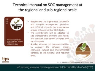
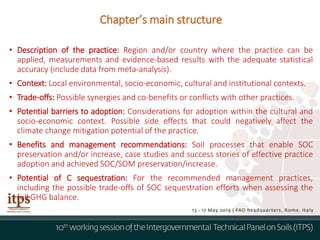
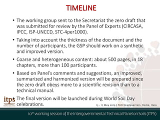
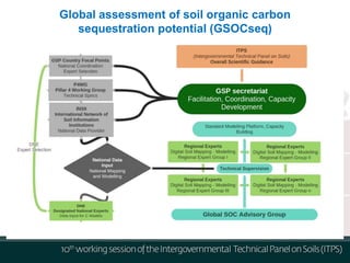
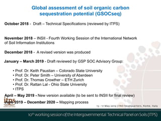
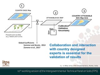
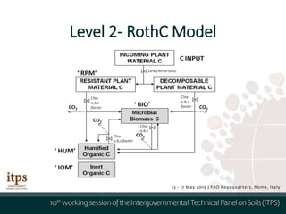
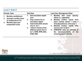
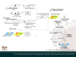
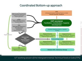
Item 7
Progress on implementation of
GSOC17
Rosa Cuevas, GSP Secretariat
Technical manual on SOC management at
the regional and sub-regional scale
• Response to the urgent need to identify
and compile management practices
and LUS that promote the preservation
and/or enhancement of SOC stocks.
• The contributions will be adapted to
site characteristics and land user needs
and consider cost-benefit analyses and
social impacts
• Another virtue of this document will be
to consider the different socio-
economic, cultural and environmental
contexts at the national and regional
level.
• Description of the practice: Region and/or country where the practice can be
applied, measurements and evidence-based results with the adequate statistical
accuracy (include data from meta-analysis).
• Context: Local environmental, socio-economic, cultural and institutional contexts.
• Trade-offs: Possible synergies and co-benefits or conflicts with other practices.
• Potential barriers to adoption: Considerations for adoption within the cultural and
socio-economic context. Possible side effects that could negatively affect the
climate change mitigation potential of the practice.
• Benefits and management recommendations: Soil processes that enable SOC
preservation and/or increase, case studies and success stories of effective practice
adoption and achieved SOC/SOM preservation/increase.
• Potential of C sequestration: For the recommended management practices,
including the possible trade-offs of SOC sequestration efforts when assessing the
full GHG balance.
Chapter’s main structure
• The working group sent to the Secretariat the zero draft that
was submitted for review by the Panel of Experts (CIRCASA,
IPCC, ISP-UNCCD, STC-4per1000).
• Taking into account the thickness of the document and the
number of participants, the GSP should work on a synthetic
and improved version.
• Coarse and heterogeneous content: about 500 pages, in 18
chapters, more than 100 participants.
• Based on Panel’s comments and suggestions, an improved,
summarized and harmonized version will be prepared since
the zero draft obeys more to a scientific revision than to a
technical manual.
• The final version will be launched during World Soil Day
celebrations.
TIMELINE
WG - Soil Organic Carbon Monitoring
• 100+ Experts
• To be released in 2019
Working group to develop feasible and regionally contextualized guidelines for measuring, mapping, monitoring and
reporting on SOC that can be adapted locally to monitor SOC stocks and stock changes to support management
decisions
1. Introduction and definitions
2. Baseline Soil Organic Carbon Stocks
2.1 Introduction
2.2 Sampling Design
2.3 Field Sampling, Sample Processing
2.4 Laboratory Methods
2.5 Bulk Density, Coarse Fragments
2.6 Data Handling
2.7 Stock Calculations
4. Modelling SOC and SOC Changes
4.1 Conventional Methods
4.2 Process Based Models
4.3 Digital Soil Mapping
5.1 Uncertainty Assessment
5.2 Sources of Uncertainty
5.3 Uncertainty Quantification
6. Reporting, Integration with GLOSIS and SoilSTAT
3.1 SOC Monitoring
3.2 SOC Monitoring Methods,
Approaches
3.3 Detection Limits
3.4 Sampling Frequency
3.5 Monitoring on Different Land
Systems (introduction)
3.5.1 Agricultural Lands, Pastures
3.5.2 Forest Lands, 3.5.3 Wetlands,
3.5.4 Grasslands, 3.5.5 Drylands
Status: Drafting Phase
International Network on Black Soils
 The International Symposium on Black Soils & First
Plenary of International Network of Black Soils (ISBS18)
have been held in Harbin on 10 - 12 September 2018.
Outputs:
1. The definition of black soils
2. Working plan of INBS
3. Harbin Communiqué
Second Plenary of INBS will hold in Moldova in October 2019
GSOCmap interpretation
Submissions
RECARBONIZATION OF GLOBAL SOILS (RECSOIL) FACILITY
Global assessment of soil organic carbon
sequestration potential (GSOCseq)
Item 10
GSOC sequestration potential
Rosa Cuevas, GSP Secretariat
Global assessment of soil organic carbon
sequestration potential (GSOCseq)
January – March 2019 - Draft reviewed by GSP SOC Advisory Group:
• Prof. Dr. Keith Paustian – Colorado State University
• Prof. Dr. Peter Smith – University of Aberdeen
• Prof. Dr. Thomas Crowther – ETH Zurich
• Prof. Dr. Rattan Lal - Ohio State University
• ITPS
October 2018 - Draft – Technical Specifications (reviewed by ITPS)
November 2018 – INSII - Fourth Working Session of the International Network
of Soil Information Institutions
December 2018 - A revised version was produced
April – May 2019 - New version available (to be sent to INSII for final review)
June 2019 – December 2020 – Mapping process
Summary. Comments from Experts
• Key principles should govern the work:
• careful coordination of data and analytical methods;
• same data sources;
• same carbon model and assumptions within a model.
• Not feasible to have semi-independent efforts (country-driven analyses) and yield
consistent results. A modelling team is needed.
• Sensitivity and uncertainty should be established.
• Inclusion of machine learning models: improve accuracy of predictions.
• Definition of a realistic and feasible 'recommended land use and management
practices’ is the main challenge.
• December 2019: not realistic deadline
Prior to modeling attainable SOC under recommended practices , the
‘empirical’ approaches described in sections 3.1 and 3.2.1 will provide a first
guide on attainable carbon levels in the different regions using: the GSOC
stocks as a base-line, and using harmonized global data sources (Land Use, soil
and Climatic Data; Table 1 , Annex 2).
As a second stage, and taking into consideration expert reviewers’ comments
(see Annex 3), a coordinated and guided ‘Bottom-up’, Level 2, modeling
approach (see section 3.2.2) is proposed (summarized in Fig. 8):
Estimating Carbon Gaps
Proposal and Way Forward
Coordinated Bottom-up approach
Soil Carbon Gaps conceptual framework
𝑆𝑂𝐶 (%) = 𝑆𝑂𝐶0 +
𝑎
1 + 𝑒−
𝑡−𝑡0
𝑏
Empirical approaches
According to the authors, the increase in % SOC in response to improved
management may be described as
• where SOC0 is the initial soil organic carbon content (%), (which shall
correspond to the GSOC Map present Stock);
• a (0.35 to 1.2) and b (9.8 to11.5) are empirical constants defined for ‘ low’ , ‘
medium’ and ‘ high’ SOC accumulation rate scenarios (and t the target time
expressed (20 years),
• and t0 is the year where the slope of the curve is largest, i.e. the annual
sequestration rate highest (assumed between 3-7 years by the authors).
Collaboration and interaction
with country designed
experts is essential for the
validation of results
Level 2- RothC Model
Level 2. Roth-C
Climate Data Soil Data Land Use- Management Data
1. Monthly rainfall(mm)
2. Average monthly mean
air temperature (ºC)
3. Monthly open pan
evaporation (mm)
1. Soil simulation depth
(cm)
2. Clay content (%) at
simulation depth.
3. Total Initial SOC stocks
(Ton C. ha-1)
4. Initial C stocks of the
different pools (Ton C.
ha-1): DPM, RPM, BIO,
HUM, IOM
1. Monthly Soil cover (binary:
fallow vs. vegetated)
2. Monthly Carbon inputs from
plant residue (aerial + roots +
rhizodepositions), (Ton C.ha-1)
3. Monthly Carbon inputs from
manure (Ton C.ha-1)
4. DPM/RPM ratio, an estimate of
the decomposability of the
incoming plant material
Coordinated Bottom-up approach
Item 7: Progress on implementation of GSOC17

Item 7: Progress on implementation of GSOC17

  • 1.
    Item 7 Progress onimplementation of GSOC17 Rosa Cuevas, GSP Secretariat
  • 2.
    Technical manual onSOC management at the regional and sub-regional scale • Response to the urgent need to identify and compile management practices and LUS that promote the preservation and/or enhancement of SOC stocks. • The contributions will be adapted to site characteristics and land user needs and consider cost-benefit analyses and social impacts • Another virtue of this document will be to consider the different socio- economic, cultural and environmental contexts at the national and regional level.
  • 3.
    • Description ofthe practice: Region and/or country where the practice can be applied, measurements and evidence-based results with the adequate statistical accuracy (include data from meta-analysis). • Context: Local environmental, socio-economic, cultural and institutional contexts. • Trade-offs: Possible synergies and co-benefits or conflicts with other practices. • Potential barriers to adoption: Considerations for adoption within the cultural and socio-economic context. Possible side effects that could negatively affect the climate change mitigation potential of the practice. • Benefits and management recommendations: Soil processes that enable SOC preservation and/or increase, case studies and success stories of effective practice adoption and achieved SOC/SOM preservation/increase. • Potential of C sequestration: For the recommended management practices, including the possible trade-offs of SOC sequestration efforts when assessing the full GHG balance. Chapter’s main structure
  • 4.
    • The workinggroup sent to the Secretariat the zero draft that was submitted for review by the Panel of Experts (CIRCASA, IPCC, ISP-UNCCD, STC-4per1000). • Taking into account the thickness of the document and the number of participants, the GSP should work on a synthetic and improved version. • Coarse and heterogeneous content: about 500 pages, in 18 chapters, more than 100 participants. • Based on Panel’s comments and suggestions, an improved, summarized and harmonized version will be prepared since the zero draft obeys more to a scientific revision than to a technical manual. • The final version will be launched during World Soil Day celebrations. TIMELINE
  • 5.
    WG - SoilOrganic Carbon Monitoring • 100+ Experts • To be released in 2019 Working group to develop feasible and regionally contextualized guidelines for measuring, mapping, monitoring and reporting on SOC that can be adapted locally to monitor SOC stocks and stock changes to support management decisions 1. Introduction and definitions 2. Baseline Soil Organic Carbon Stocks 2.1 Introduction 2.2 Sampling Design 2.3 Field Sampling, Sample Processing 2.4 Laboratory Methods 2.5 Bulk Density, Coarse Fragments 2.6 Data Handling 2.7 Stock Calculations 4. Modelling SOC and SOC Changes 4.1 Conventional Methods 4.2 Process Based Models 4.3 Digital Soil Mapping 5.1 Uncertainty Assessment 5.2 Sources of Uncertainty 5.3 Uncertainty Quantification 6. Reporting, Integration with GLOSIS and SoilSTAT 3.1 SOC Monitoring 3.2 SOC Monitoring Methods, Approaches 3.3 Detection Limits 3.4 Sampling Frequency 3.5 Monitoring on Different Land Systems (introduction) 3.5.1 Agricultural Lands, Pastures 3.5.2 Forest Lands, 3.5.3 Wetlands, 3.5.4 Grasslands, 3.5.5 Drylands Status: Drafting Phase
  • 6.
    International Network onBlack Soils  The International Symposium on Black Soils & First Plenary of International Network of Black Soils (ISBS18) have been held in Harbin on 10 - 12 September 2018. Outputs: 1. The definition of black soils 2. Working plan of INBS 3. Harbin Communiqué Second Plenary of INBS will hold in Moldova in October 2019
  • 7.
  • 8.
  • 9.
  • 10.
  • 12.
    RECARBONIZATION OF GLOBALSOILS (RECSOIL) FACILITY
  • 13.
    Global assessment ofsoil organic carbon sequestration potential (GSOCseq)
  • 15.
    Item 10 GSOC sequestrationpotential Rosa Cuevas, GSP Secretariat
  • 16.
    Global assessment ofsoil organic carbon sequestration potential (GSOCseq) January – March 2019 - Draft reviewed by GSP SOC Advisory Group: • Prof. Dr. Keith Paustian – Colorado State University • Prof. Dr. Peter Smith – University of Aberdeen • Prof. Dr. Thomas Crowther – ETH Zurich • Prof. Dr. Rattan Lal - Ohio State University • ITPS October 2018 - Draft – Technical Specifications (reviewed by ITPS) November 2018 – INSII - Fourth Working Session of the International Network of Soil Information Institutions December 2018 - A revised version was produced April – May 2019 - New version available (to be sent to INSII for final review) June 2019 – December 2020 – Mapping process
  • 17.
    Summary. Comments fromExperts • Key principles should govern the work: • careful coordination of data and analytical methods; • same data sources; • same carbon model and assumptions within a model. • Not feasible to have semi-independent efforts (country-driven analyses) and yield consistent results. A modelling team is needed. • Sensitivity and uncertainty should be established. • Inclusion of machine learning models: improve accuracy of predictions. • Definition of a realistic and feasible 'recommended land use and management practices’ is the main challenge. • December 2019: not realistic deadline
  • 18.
    Prior to modelingattainable SOC under recommended practices , the ‘empirical’ approaches described in sections 3.1 and 3.2.1 will provide a first guide on attainable carbon levels in the different regions using: the GSOC stocks as a base-line, and using harmonized global data sources (Land Use, soil and Climatic Data; Table 1 , Annex 2). As a second stage, and taking into consideration expert reviewers’ comments (see Annex 3), a coordinated and guided ‘Bottom-up’, Level 2, modeling approach (see section 3.2.2) is proposed (summarized in Fig. 8): Estimating Carbon Gaps Proposal and Way Forward
  • 19.
  • 20.
    Soil Carbon Gapsconceptual framework
  • 21.
    𝑆𝑂𝐶 (%) =𝑆𝑂𝐶0 + 𝑎 1 + 𝑒− 𝑡−𝑡0 𝑏 Empirical approaches According to the authors, the increase in % SOC in response to improved management may be described as • where SOC0 is the initial soil organic carbon content (%), (which shall correspond to the GSOC Map present Stock); • a (0.35 to 1.2) and b (9.8 to11.5) are empirical constants defined for ‘ low’ , ‘ medium’ and ‘ high’ SOC accumulation rate scenarios (and t the target time expressed (20 years), • and t0 is the year where the slope of the curve is largest, i.e. the annual sequestration rate highest (assumed between 3-7 years by the authors).
  • 22.
    Collaboration and interaction withcountry designed experts is essential for the validation of results
  • 23.
  • 24.
    Level 2. Roth-C ClimateData Soil Data Land Use- Management Data 1. Monthly rainfall(mm) 2. Average monthly mean air temperature (ºC) 3. Monthly open pan evaporation (mm) 1. Soil simulation depth (cm) 2. Clay content (%) at simulation depth. 3. Total Initial SOC stocks (Ton C. ha-1) 4. Initial C stocks of the different pools (Ton C. ha-1): DPM, RPM, BIO, HUM, IOM 1. Monthly Soil cover (binary: fallow vs. vegetated) 2. Monthly Carbon inputs from plant residue (aerial + roots + rhizodepositions), (Ton C.ha-1) 3. Monthly Carbon inputs from manure (Ton C.ha-1) 4. DPM/RPM ratio, an estimate of the decomposability of the incoming plant material
  • 26.

Editor's Notes

  • #4 Recommended management practices and actions for preservation and/or enhancement of SOC Unmanaged and Protected Lands (including virgin forests, rangelands, grassland, shrublands, Forestry (managed/silviculture). Forestry with agricultural or livestock activities: agroforestry, silvopastoral systems. Grassland, shrublands, and bare and sparse areas with low, moderate, and high livestock density. Rainfed agriculture - subsistence and familiar. Rainfed agriculture – commercial. Irrigated agriculture. Rainfed or irrigated agriculture with livestock. Urban areas. Wetlands with agricultural activities.
  • #5 Submission of chapters – by 30 November 2018 Editing to harmonize chapters (ITPS/GSP Secretariat, feedback process with lead authors) - by 30 December 2019. Review by ITPS,UNCCD-SPI,IPCC, CIRCASA, 4per1000 – by 31 January 2019. Preparation of final version – by 30 March 2018. Final review and clearance by ITPS – by 30 April 2018 Layout and printing – by 30 May 2019. Launch of the Technical Manual on Soil Organic Carbon management at the regional and sub-regional scale during the seventh Plenary Assembly of the Global Soil Partnership – from 5 to 7 June 2019.
  • #14 The use of a single ‘soil-centered’ carbon model is proposed, in order to obtain consistent results. Based on its widespread use, fewer data requirements, and relative simplicity to obtain input data compared to other models, Roth-C model is suggested. Modeling, data analysis and digital mapping should be performed by country designed experts, following a standard protocol. Careful coordination and harmonization of climatic, land cover, soil data (same resolution) required as direct or indirect inputs, and election of defined data sources is essential in order to obtain consistent results among regions and countries. National expert opinion (local extensionists, local researchers, local officers) is required in order to current and feasible ‘improved’ land use/management practices, required as direct or indirect inputs to run the models. The role of National experts/analysts is also key to interpreting, discussing and supervising preliminary and final results. The set-up of a team of regional modeling-digital mapping experts is proposed, in order to develop protocols (‘Cook-book’), develop technical capacity in different countries and regions through technical work-shops, and to coordinate and guide national modeling and mapping activities General technical guidance and supervision by a group of designated expert advisers (SOC Advisory Group) is proposed.
  • #19 As mentioned in section 1 (Fig. 1), ‘Soil Carbon Gaps’ can be determined, by estimating the difference between actual Soil Organic Carbon (SOC) stocks; attainable SOC stocks and SOC Saturation Levels. An estimate of Carbon saturation should be relatively easy to obtain from soil texture information.
  • #20 The use of a single ‘soil-centered’ carbon model is proposed, in order to obtain consistent results. Based on its widespread use, fewer data requirements, and relative simplicity to obtain input data compared to other models, Roth-C model is suggested. Modeling, data analysis and digital mapping should be performed by country designed experts, following a standard protocol. Careful coordination and harmonization of climatic, land cover, soil data (same resolution) required as direct or indirect inputs, and election of defined data sources is essential in order to obtain consistent results among regions and countries. National expert opinion (local extensionists, local researchers, local officers) is required in order to current and feasible ‘improved’ land use/management practices, required as direct or indirect inputs to run the models. The role of National experts/analysts is also key to interpreting, discussing and supervising preliminary and final results. The set-up of a team of regional modeling-digital mapping experts is proposed, in order to develop protocols (‘Cook-book’), develop technical capacity in different countries and regions through technical work-shops, and to coordinate and guide national modeling and mapping activities General technical guidance and supervision by a group of designated expert advisers (SOC Advisory Group) is proposed.
  • #27 The use of a single ‘soil-centered’ carbon model is proposed, in order to obtain consistent results. Based on its widespread use, fewer data requirements, and relative simplicity to obtain input data compared to other models, Roth-C model is suggested. Modeling, data analysis and digital mapping should be performed by country designed experts, following a standard protocol. Careful coordination and harmonization of climatic, land cover, soil data (same resolution) required as direct or indirect inputs, and election of defined data sources is essential in order to obtain consistent results among regions and countries. National expert opinion (local extensionists, local researchers, local officers) is required in order to current and feasible ‘improved’ land use/management practices, required as direct or indirect inputs to run the models. The role of National experts/analysts is also key to interpreting, discussing and supervising preliminary and final results. The set-up of a team of regional modeling-digital mapping experts is proposed, in order to develop protocols (‘Cook-book’), develop technical capacity in different countries and regions through technical work-shops, and to coordinate and guide national modeling and mapping activities General technical guidance and supervision by a group of designated expert advisers (SOC Advisory Group) is proposed.