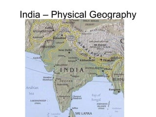
India – Physical Geography
•Download as PPT, PDF•
5 likes•3,491 views
India has several prominent physical features including the Himalayan mountain range, the Deccan Plateau, the Ganges Plain, the Western Ghats along the southwest coast, the Thar Desert in the northwest, and the southwestern coastal region.
Report
Share
Report
Share

Recommended
GEOGRAPHY OF INDIA
India has significant geographical diversity due to its large size and location in South Asia. It spans a wide range of landscapes from the Himalayan mountains in the north to the Thar Desert in the west. Major rivers like the Ganges and Indus flow from the Himalayas across fertile plains, influencing settlement patterns and supporting agriculture. India experiences distinct seasonal changes including a summer monsoon season that is crucial for crop growth. This diversity of terrain and climate has endowed India with valuable natural resources but also environmental challenges like floods and droughts.
Geography of india
This document discusses natural resources in India, including problems with their development and depletion. It summarizes the Chipko movement of forest conservation from the 1970s and mentions citizens' groups continuing its efforts today. Details are provided on soil types in India, causes of soil erosion like deforestation, and government efforts to address pollution and sustainable development. The Rio Earth Summit of 1992 and its agreements to address climate change and biodiversity are also summarized.
Geography- India Size and Location
India is located in South Asia and has a population of over 1 billion people, making it the second most populous country in the world. It has a diverse landscape that extends from the Himalayan mountains in the north to the Thar Desert in the west and the Bay of Bengal and Arabian Sea to the south and southeast. India's central location between East and West Asia has allowed it to establish close contacts with other regions throughout history through land and maritime trade routes, facilitating the exchange of ideas, religions, and goods. India shares land borders with Pakistan, Afghanistan, China, Nepal, Bhutan, and Bangladesh.
India size and location. ch 1
India lies entirely in the Northern Hemisphere between latitudes 8°4'N and 37°6'N and longitudes 68°7'E and 97°25'E. It has a total land area of 3.28 million square kilometers, which accounts for about 2.4% of the world's total area. India shares land borders with Pakistan, Afghanistan, China, Nepal, Bhutan, Bangladesh, and Myanmar, and is also neighbors with Sri Lanka and the Maldives across water.
India size and location
India is located in South Asia, with the Tropic of Cancer dividing the country into northern and southern regions. It has a total land area of 3.28 million square kilometers, making it the seventh largest country by area. India shares land borders with Pakistan and Afghanistan to the northwest, China, Nepal, and Bhutan to the north, and Bangladesh and Myanmar to the east. The southern neighbors across the sea are Sri Lanka and Maldives.
India: size and location
1. The document discusses the various physiographic units of India, including the Northern Mountains, Great Plains, Thar Desert, Central Highlands, Peninsular Plateaus, Coastal Plains, and Islands.
2. It provides information on each unit, such as their respective areas in square kilometers and percentages of India's total land area.
3. The Great Plains are further divided into subsections like the Punjab-Haryana Plain, Ganga Plain, North Bengal Plains, and Brahmaputra Plains. Details are given about each subsection.
India Presentation
This document provides an overview of India, including brief sections on its history, geography, neighbours, religions, culture, ways of life, and symbols. It discusses India's ancient civilizations, periods under Mughal and British rule, and its path to independence. Key facts noted include India having the second largest population in the world, with over 20 official languages and religious diversity, notably Hindu, Muslim, Sikh, Buddhist and Christian populations. The document also summarizes aspects of Indian culture like the caste system, importance of family and relationships, and role of religion in daily life.
Sst ppt on physical features of india
India has a variety of landforms created by geological processes over time. It has mountains, plains, deserts, and plateaus formed during different geological periods. India's relief has also been modified by weathering, erosion, and deposition. The Himalayas were formed by the collision of the Indian and Eurasian tectonic plates over millions of years, which caused the sediments of the former Tethys Sea to fold and uplift into mountains. The northern plains were formed by deposits of the Indus, Ganges, and Brahmaputra river systems and their tributaries. The Peninsular Plateau in southern India was formed from the oldest rock of the former Gondwana land and is divided into
Plains of India
There are two main types of plains in India: the Northern Plains and the Coastal Plains. The Northern Plains, also known as the Indo-Gangetic Plains, stretch from Punjab to Assam. They are made up of very fertile alluvial soil and contain three major river systems: the Ganga, Brahmaputra, and Satluj. The Coastal Plains are along India's western and eastern coasts. The Western Coastal Plains run along the Arabian Sea from Gujarat to Kanyakumari, containing gulfs and flat lands rich in oil. The Eastern Coastal Plains contain the fertile Coromandel Coast between the Krishna and Kaveri rivers, forming large river deltas.
NORTHERN PLAINS
The northern plain of India has been formed by the deposition of alluvial soil over millions of years by the Indus, Ganga, and Brahmaputra river systems along with their tributaries. It spreads over an area of 7 lakh square km and is densely populated. The rivers deposit silt in their lower courses, forming distributaries and riverine islands. The northern plain is divided into the Punjab plain in the west formed by the Indus and its tributaries, the Ganga plain in the center, and the Brahmaputra plain in the east. The land contains diverse relief features like bhabar, terai, bhangar, and khadar soils deposited in belts parallel to
ppt on plains
This document defines plains and describes the different types of plains. There are three main types of plains: structural plains, which are formed by endogenic forces raising or lowering the Earth's surface; erosional plains, which were originally rugged areas that were leveled by agents of erosion like rivers, wind, waves, and glaciers; and depositional plains, which are formed by external agents like running water, wind, glaciers, and sea waves carrying rock materials from hills and depositing them in depressions. The document provides examples of the different agents that can cause erosion and deposition in the formation of each type of plain.
India size & location by Ayush Dabra
India is located in Southern Asia, between the Indian Ocean and the Himalayas. It has a total area of 3.28 million square km and land borders over 15,200 km long. India's central location between East and West Asia has given it a strategic position connecting Europe, Africa, West Asia, Southeast Asia, and East Asia by land and sea routes. India has a long coastline on the Indian Ocean and shares land borders with Pakistan, Afghanistan, China, Nepal, Bhutan, Bangladesh, Myanmar, and maritime borders with Sri Lanka and Maldives.
Latitudes and longitudes and india size and location
This presentation covers the following topics:
1. Geographic coordinate system, i.e, latitude and longitudes
2. Size and location of India
(because before understanding the size and location our country, Geographic coordinate system, i.e, latitude and longitudes are important)
which enables the students to locate all four hemispheres including
Northern Hemisphere
Southern Hemisphere
Eastern Hemisphere
Western Hemisphere
Students will be able to identify which line divides the earth into the correct hemispheres.
Students will be able to find locations on map using longitude and latitude.
Soils of India/ Karnataka State New syllabus/ Social Science/ Geography/ Chap...
Soils of India/ Karnataka State New syllabus/ Social Science/ Geography/ Chap...Jaidas Puthan Veetil
Soil is formed by weathering of rocks under different climates and deposited by denudation agents. The main types of soil in India are alluvial soil found in river plains, black soil suited for cotton in central India, red soil covering much of the Deccan plateau, laterite soil in high rainfall areas, desert soil in arid northwest India, and mountain soil rich in nutrients. Soil erosion due to factors like deforestation, overgrazing, and unscientific farming methods needs to be prevented through conservation methods like contour ploughing, bunds, terracing, afforestation, and controlled grazing/irrigation.INDIA - SIZE AND LOCATION
IN THIS SLIDE YOU WILL LEARN ABOUT INDIA'S SIZE, LOCATION, INDIA'S NEIGHBORHOOD AND INDIA IN THE WORLD.
India size and location
This document provides information about India's location and geography. It discusses India's location in relation to latitude and longitude lines. It notes that India's total land area is 3.28 million square km, accounting for about 2.4% of the world's total land area. The document also outlines India's land and coastal boundaries, mentioning it shares borders with Pakistan, Afghanistan, China, Nepal, Bhutan, Myanmar, and Bangladesh. It provides context on India's strategic central location between East and West Asia.
The northern plains ppt
The northern plain of India is formed by the interplay of three major rivers - the Ganga, Indus, and Brahmaputra. During the Tertiary period, a sea called Tethys extended north and west. Due to the movement of tectonic plates, the Indian plate underthrust the Eurasian plate, causing folding of marine sediments from compressive forces. This created the Himalayas and left the northern plain as a foredeep filled with sediments eroded from the mountains. The three dominant rivers continue depositing alluvial soil, making the plain one of the most fertile regions and important agricultural areas in India.
Introduction to political science
An introduction to political science, its definition, etymology, scope, function and goal, and relation to other branches of knowledge.
India PPT
India is located in South Asia between Pakistan, China, and Nepal. It has over 1 billion people and is the largest democracy in the world. India has a long history dating back 5,000 years and was home to ancient civilizations like the Indus Valley Civilization. It is very diverse with over 300 languages and many major religions coexisting. Some of India's most notable contributions are yoga, Ayurveda, the number zero, and being the birthplace of Buddhism, Hinduism, Jainism, and Sikhism. India celebrates many festivals and has rich cultural traditions like classical dance, music, art, and architecture.
Physical features of India
India has several physical features including mountains, rivers, plains, and plateaus. The Himalayas and Hindu Kush mountains lie to the north. Major rivers include the Ganges and Indus. The large and fertile Indo-Gangetic Plain spans northern and eastern India. South India's Deccan Plateau rises up to 1 km high. Coastal areas include the Eastern and Western Coastal Plains. Islands include the Lakshadweep and Andaman and Nicobar Islands.
Natlai soto ramirez
El documento trata sobre el respeto como valor fundamental en las relaciones interpersonales y entre grupos. Define el respeto como el reconocimiento de los intereses y sentimientos de los demás. También destaca que todos merecen respeto a la vida humana, la libertad y el derecho a la felicidad, ya que sin respeto no puede haber convivencia entre las personas.
World Geography India & Pak
This document provides information about India and Pakistan through maps, images and text. It summarizes their histories, including the partition of British India in 1947 which led to the creation of India and Pakistan as two independent dominions. It also discusses the countries' cultures, economies, relations and tensions over topics like the disputed Kashmir region, which have included multiple wars and ongoing political and military conflicts. Cricket matches between the national teams are also noted as being highly emotive due to the countries' rivalry. In conclusion, the document questions whether the ongoing "cold war" between India and Pakistan will ever end.
Welcome
This document provides an overview of the historical and cultural geography of North America. It discusses the major geographic regions of North America and their climates. It then focuses on the history and settlement patterns of various regions in North America, including exploration by Europeans, the French and Spanish settlements, the 13 original British colonies, and the cultural differences that developed between the North and South of the United States.
Zimmer Twins
The document discusses the Zimmer Twins, a Canadian children's website and animation project created by Jason Krogh and Aaron Leighton. It describes the main characters - twins Edgar and Eva Zimmer and their psychic black cat 13. The website allows kids to create their own animated stories and movie endings using characters, actions, props and backgrounds. Teachers can use the Zimmer Twins website in the classroom to get students writing stories, practicing language skills, and demonstrating their understanding and creativity.
The cartoon museum
This trip is planned for a Year 4 class to visit the Cartoon Museum in London. The museum has exhibitions that change frequently and are suitable for modifying for different KS2 classes. It also has a private workshop space upstairs that schools can use. The aim of the trip is to provide stimulus for science, geography, philosophy, and art lessons through a workshop at the museum about global warming and the future, where students will create their own comic strips. The workshop focuses on teaching students how to construct comics and reflect on climate change through an example graphic novel. A professional engineer will guide the session. [END SUMMARY]
The Paradox of Contemporary India
India is a nation of great contrasts, with both wealth and extreme poverty existing side by side. While some parts of India have experienced rapid economic growth and a new middle class has emerged, much of the population still lives in dire poverty without access to basic necessities. Over half of India's population lives below the poverty line, and millions of children suffer from malnutrition and lack of healthcare or access to education. The disparities between the wealthy elite and most Indians highlight the paradox of modern India.
Haiti earthquake yr7
The 2010 Haiti earthquake that killed over 200,000 people was caused by movement along the boundary between the Caribbean and North American tectonic plates. Haiti sits along a conservative plate boundary where the plates move about 20 mm per year, building pressure until an earthquake occurs. A 7 magnitude earthquake struck just 15 km from the capital Port-au-Prince on January 12, 2010. The shallow depth of 13 km exacerbated the damage. Over 1.5 million people were left homeless as much of Port-au-Prince was destroyed, including important buildings and infrastructure. The poor conditions in Haiti made providing relief extremely difficult in the aftermath.
Zulu
The Zulu tribe originated in South Africa and are known for their brightly colored beads and baskets. They have a variety of traditional foods like sour milk, beer, and maize porridge. Zulu warriors dress distinctively, while British teenagers dress more casually. Zulu houses are made from simple materials like straw and dung, and are positioned based on the occupants' work, with farmers living near fields and workers near jobsites. The tribe was placed under British rule in the 1800s but regained independence after a war in 1906.
Tuareg
The Tuareg people number around 5.2 million living primarily in Niger, Mali, Algeria, Burkina Faso, and Libya. They are traditionally nomadic herders who wear distinctive blue or black veils and live in tents. The Tuareg society was historically divided between pastoralists and farmers, and they have resisted full adoption of Islam while integrating some rituals and holidays. Their staple foods include milk, porridge, bread, and cheeses from goats.
Dinka
The Dinka tribe originated from southern Sudan but many have migrated elsewhere due to civil war. They traditionally wore little clothing, with men going naked and women wearing goatskin skirts. The Dinka population is over 1 million and they speak the Dinka language, though some have relocated to places like Khartoum with different cultures.
More Related Content
Viewers also liked
Plains of India
There are two main types of plains in India: the Northern Plains and the Coastal Plains. The Northern Plains, also known as the Indo-Gangetic Plains, stretch from Punjab to Assam. They are made up of very fertile alluvial soil and contain three major river systems: the Ganga, Brahmaputra, and Satluj. The Coastal Plains are along India's western and eastern coasts. The Western Coastal Plains run along the Arabian Sea from Gujarat to Kanyakumari, containing gulfs and flat lands rich in oil. The Eastern Coastal Plains contain the fertile Coromandel Coast between the Krishna and Kaveri rivers, forming large river deltas.
NORTHERN PLAINS
The northern plain of India has been formed by the deposition of alluvial soil over millions of years by the Indus, Ganga, and Brahmaputra river systems along with their tributaries. It spreads over an area of 7 lakh square km and is densely populated. The rivers deposit silt in their lower courses, forming distributaries and riverine islands. The northern plain is divided into the Punjab plain in the west formed by the Indus and its tributaries, the Ganga plain in the center, and the Brahmaputra plain in the east. The land contains diverse relief features like bhabar, terai, bhangar, and khadar soils deposited in belts parallel to
ppt on plains
This document defines plains and describes the different types of plains. There are three main types of plains: structural plains, which are formed by endogenic forces raising or lowering the Earth's surface; erosional plains, which were originally rugged areas that were leveled by agents of erosion like rivers, wind, waves, and glaciers; and depositional plains, which are formed by external agents like running water, wind, glaciers, and sea waves carrying rock materials from hills and depositing them in depressions. The document provides examples of the different agents that can cause erosion and deposition in the formation of each type of plain.
India size & location by Ayush Dabra
India is located in Southern Asia, between the Indian Ocean and the Himalayas. It has a total area of 3.28 million square km and land borders over 15,200 km long. India's central location between East and West Asia has given it a strategic position connecting Europe, Africa, West Asia, Southeast Asia, and East Asia by land and sea routes. India has a long coastline on the Indian Ocean and shares land borders with Pakistan, Afghanistan, China, Nepal, Bhutan, Bangladesh, Myanmar, and maritime borders with Sri Lanka and Maldives.
Latitudes and longitudes and india size and location
This presentation covers the following topics:
1. Geographic coordinate system, i.e, latitude and longitudes
2. Size and location of India
(because before understanding the size and location our country, Geographic coordinate system, i.e, latitude and longitudes are important)
which enables the students to locate all four hemispheres including
Northern Hemisphere
Southern Hemisphere
Eastern Hemisphere
Western Hemisphere
Students will be able to identify which line divides the earth into the correct hemispheres.
Students will be able to find locations on map using longitude and latitude.
Soils of India/ Karnataka State New syllabus/ Social Science/ Geography/ Chap...
Soils of India/ Karnataka State New syllabus/ Social Science/ Geography/ Chap...Jaidas Puthan Veetil
Soil is formed by weathering of rocks under different climates and deposited by denudation agents. The main types of soil in India are alluvial soil found in river plains, black soil suited for cotton in central India, red soil covering much of the Deccan plateau, laterite soil in high rainfall areas, desert soil in arid northwest India, and mountain soil rich in nutrients. Soil erosion due to factors like deforestation, overgrazing, and unscientific farming methods needs to be prevented through conservation methods like contour ploughing, bunds, terracing, afforestation, and controlled grazing/irrigation.INDIA - SIZE AND LOCATION
IN THIS SLIDE YOU WILL LEARN ABOUT INDIA'S SIZE, LOCATION, INDIA'S NEIGHBORHOOD AND INDIA IN THE WORLD.
India size and location
This document provides information about India's location and geography. It discusses India's location in relation to latitude and longitude lines. It notes that India's total land area is 3.28 million square km, accounting for about 2.4% of the world's total land area. The document also outlines India's land and coastal boundaries, mentioning it shares borders with Pakistan, Afghanistan, China, Nepal, Bhutan, Myanmar, and Bangladesh. It provides context on India's strategic central location between East and West Asia.
The northern plains ppt
The northern plain of India is formed by the interplay of three major rivers - the Ganga, Indus, and Brahmaputra. During the Tertiary period, a sea called Tethys extended north and west. Due to the movement of tectonic plates, the Indian plate underthrust the Eurasian plate, causing folding of marine sediments from compressive forces. This created the Himalayas and left the northern plain as a foredeep filled with sediments eroded from the mountains. The three dominant rivers continue depositing alluvial soil, making the plain one of the most fertile regions and important agricultural areas in India.
Introduction to political science
An introduction to political science, its definition, etymology, scope, function and goal, and relation to other branches of knowledge.
India PPT
India is located in South Asia between Pakistan, China, and Nepal. It has over 1 billion people and is the largest democracy in the world. India has a long history dating back 5,000 years and was home to ancient civilizations like the Indus Valley Civilization. It is very diverse with over 300 languages and many major religions coexisting. Some of India's most notable contributions are yoga, Ayurveda, the number zero, and being the birthplace of Buddhism, Hinduism, Jainism, and Sikhism. India celebrates many festivals and has rich cultural traditions like classical dance, music, art, and architecture.
Physical features of India
India has several physical features including mountains, rivers, plains, and plateaus. The Himalayas and Hindu Kush mountains lie to the north. Major rivers include the Ganges and Indus. The large and fertile Indo-Gangetic Plain spans northern and eastern India. South India's Deccan Plateau rises up to 1 km high. Coastal areas include the Eastern and Western Coastal Plains. Islands include the Lakshadweep and Andaman and Nicobar Islands.
Natlai soto ramirez
El documento trata sobre el respeto como valor fundamental en las relaciones interpersonales y entre grupos. Define el respeto como el reconocimiento de los intereses y sentimientos de los demás. También destaca que todos merecen respeto a la vida humana, la libertad y el derecho a la felicidad, ya que sin respeto no puede haber convivencia entre las personas.
World Geography India & Pak
This document provides information about India and Pakistan through maps, images and text. It summarizes their histories, including the partition of British India in 1947 which led to the creation of India and Pakistan as two independent dominions. It also discusses the countries' cultures, economies, relations and tensions over topics like the disputed Kashmir region, which have included multiple wars and ongoing political and military conflicts. Cricket matches between the national teams are also noted as being highly emotive due to the countries' rivalry. In conclusion, the document questions whether the ongoing "cold war" between India and Pakistan will ever end.
Welcome
This document provides an overview of the historical and cultural geography of North America. It discusses the major geographic regions of North America and their climates. It then focuses on the history and settlement patterns of various regions in North America, including exploration by Europeans, the French and Spanish settlements, the 13 original British colonies, and the cultural differences that developed between the North and South of the United States.
Zimmer Twins
The document discusses the Zimmer Twins, a Canadian children's website and animation project created by Jason Krogh and Aaron Leighton. It describes the main characters - twins Edgar and Eva Zimmer and their psychic black cat 13. The website allows kids to create their own animated stories and movie endings using characters, actions, props and backgrounds. Teachers can use the Zimmer Twins website in the classroom to get students writing stories, practicing language skills, and demonstrating their understanding and creativity.
The cartoon museum
This trip is planned for a Year 4 class to visit the Cartoon Museum in London. The museum has exhibitions that change frequently and are suitable for modifying for different KS2 classes. It also has a private workshop space upstairs that schools can use. The aim of the trip is to provide stimulus for science, geography, philosophy, and art lessons through a workshop at the museum about global warming and the future, where students will create their own comic strips. The workshop focuses on teaching students how to construct comics and reflect on climate change through an example graphic novel. A professional engineer will guide the session. [END SUMMARY]
The Paradox of Contemporary India
India is a nation of great contrasts, with both wealth and extreme poverty existing side by side. While some parts of India have experienced rapid economic growth and a new middle class has emerged, much of the population still lives in dire poverty without access to basic necessities. Over half of India's population lives below the poverty line, and millions of children suffer from malnutrition and lack of healthcare or access to education. The disparities between the wealthy elite and most Indians highlight the paradox of modern India.
Viewers also liked (18)
Latitudes and longitudes and india size and location
Latitudes and longitudes and india size and location
Soils of India/ Karnataka State New syllabus/ Social Science/ Geography/ Chap...
Soils of India/ Karnataka State New syllabus/ Social Science/ Geography/ Chap...
More from Darron Gray
Haiti earthquake yr7
The 2010 Haiti earthquake that killed over 200,000 people was caused by movement along the boundary between the Caribbean and North American tectonic plates. Haiti sits along a conservative plate boundary where the plates move about 20 mm per year, building pressure until an earthquake occurs. A 7 magnitude earthquake struck just 15 km from the capital Port-au-Prince on January 12, 2010. The shallow depth of 13 km exacerbated the damage. Over 1.5 million people were left homeless as much of Port-au-Prince was destroyed, including important buildings and infrastructure. The poor conditions in Haiti made providing relief extremely difficult in the aftermath.
Zulu
The Zulu tribe originated in South Africa and are known for their brightly colored beads and baskets. They have a variety of traditional foods like sour milk, beer, and maize porridge. Zulu warriors dress distinctively, while British teenagers dress more casually. Zulu houses are made from simple materials like straw and dung, and are positioned based on the occupants' work, with farmers living near fields and workers near jobsites. The tribe was placed under British rule in the 1800s but regained independence after a war in 1906.
Tuareg
The Tuareg people number around 5.2 million living primarily in Niger, Mali, Algeria, Burkina Faso, and Libya. They are traditionally nomadic herders who wear distinctive blue or black veils and live in tents. The Tuareg society was historically divided between pastoralists and farmers, and they have resisted full adoption of Islam while integrating some rituals and holidays. Their staple foods include milk, porridge, bread, and cheeses from goats.
Dinka
The Dinka tribe originated from southern Sudan but many have migrated elsewhere due to civil war. They traditionally wore little clothing, with men going naked and women wearing goatskin skirts. The Dinka population is over 1 million and they speak the Dinka language, though some have relocated to places like Khartoum with different cultures.
Fulani
The Fulani Tribe is an ethnic group spread across several West African countries including Guinea, Mali, The Gambia, and Nigeria. They originated in the 1st century AD and are primarily known as nomadic herders, though many now live in villages. Traditionally, the Fulani wear colorful, embroidered robes and hats. Women decorate themselves with jewelry. Their staple foods are millet, milk, and meat from their cattle herds, which are a sign of wealth. They live in dome-shaped houses during dry seasons and mat-covered houses during wet seasons.
Dinka
The Dinka tribe inhabits the Bahr el Ghazal region of South Sudan and numbers around 1.5 million people, making up 10% of Sudan's population. They mainly live in rural areas and have a long history involving wars with other tribes. The Dinka have a monotheistic religion centered around Nhialic as the creator and source of life and death, performing rituals for events like births, deaths, and times of crisis. Their traditional diet consists of milk, meat, fish, beans, tomatoes, and rice.
Maasai
The Maasai live in East Africa and are known as herders and warriors. They rely on cattle for their livelihood, drinking milk and eating meat, though now also grow some crops. Maasai society is organized into male age groups that perform initiations and take on roles. They believe in the god Ngai, who created all and sent cattle to the Maasai via the wild fig tree. The Maasai live in traditional huts and villages, believe Ngai entrusted cattle to them, measure wealth by cattle, do rainmaking rituals during drought, wear distinctive hairstyles, and drink cows' blood for strength.
Year 9 volcanoes display
The display at St Ives Town Library is about volcanoes and is aimed at Year 9 students. It will feature information about how volcanoes are formed and erupt, including the different types of eruptions. Interactive exhibits will allow students to learn in an engaging hands-on way about volcanic processes and the destructive but also creative forces of nature.
Yr9 volcanoes revision
This document provides revision materials for a Year 9 geography exam on volcanoes. It includes information on plate tectonics such as the four main types of plate boundaries (constructive, destructive, conservative, collision), and how each relates to volcanic activity. It also gives a case study on the 1997 eruption of the Soufrière Hills Volcano on the island of Montserrat in the Caribbean, which was caused by subduction at a destructive plate boundary. The document concludes with sample exam questions testing understanding of the materials presented.
What country am I?
I am located in Africa, my flag contains three horizontal bands of green, yellow, and red with a large Maasai shield in the center, and I am named after Mount Kilimanjaro and home to the Maasai tribe in Africa.
St ivo school geography department photo competition 2010
The St Ivo School Geography Department held a photo competition in 2010 and the winner was Hannah L from Bourg 'Arud. Several other students also had photos submitted including Christopher G, George M, James T, Jasmine A, Elsa H, Cameron C, Laura F, Ryan H, Stanley W, Stefan G 1, Stefan G 2, Zoe B, and Niall T, Bethany M.
Tsunami Poem
The document describes the 2004 Indian Ocean tsunami and its devastating impact across South and Southeast Asian coastal regions. It includes a poem titled "Tsunami You Hit My Island Home" describing the tsunami's destruction from the perspective of Sri Lankans. It then tasks the reader to write their own poem titled "The Tsunami" from the perspective of either Amanthi or Muttiah, two characters mentioned, imagining what it would have been like to experience the tsunami firsthand. The poem should convey what was seen, felt, and heard, and what happened to friends and family through structured stanzas telling the story.
India Location And History
The document summarizes the history of India and the Indian subcontinent. It discusses how India was ruled by many empires due to its strategic location and natural resources. In 1947, British India was partitioned into the Dominion of Pakistan and the Union of India. The partition split the provinces of Punjab and Bengal along religious lines, dividing the regions between predominantly Hindu India and Muslim Pakistan. India has since become the second most populous country and has undergone rapid economic changes.
Indian Cuisine
Indian cuisine varies widely by region due to differences in climate, available ingredients, wealth, water access, livestock, and cultural customs. Rajasthan cuisine in the Thar Desert relies heavily on dairy and curried dishes to preserve food. Goan cuisine shows Portuguese influences like vindaloo and uses coconut milk and seafood. Mumbai cuisine features vegetables, spices, peanuts, and cashews as the region has fertile farms. Northern cuisines popular in the UK include flatbreads, tandoori cooking, samosas, and rich curries. Southern coastal cuisine is very spicy and uses coconuts and seafood. Eastern cuisine centers around fish and rice with few meat options. British colonization led Indian
Indian Cities
The document lists and provides some key details about 11 major cities in India. Mumbai is the largest city with over 17 million people and is known as the gateway to India. Kolkata has over 13.5 million people and is home to the Victoria Memorial landmark. New Delhi, the capital, has a population of 13 million and is where the President's Palace is located.
Yr9 Revision Powerpoint
This document provides information about plate tectonics and volcanoes for a Year 9 geography exam revision. It describes the four main types of plate boundaries: constructive where plates move apart and volcanoes form as magma rises; destructive where one plate subducts under another and friction melts the plates causing volcanic eruptions; conservative where plates slide past each other without volcanism; and collision where continental plates collide and fold mountains form. Details are given about the Montserrat volcano eruption in 1997 and its effects on the island. The document concludes with a 10 question quiz to test understanding.
Photo Comp Results
The document lists the names of various individuals alongside locations. It appears to be recording the placements or accomplishments of different people in various competitions, locations visited, or events attended, as the names are followed by places or activities with some recipients being highly commended.
Postcard Wall
The geography department at St Ivo has started a postcard wall where students are encouraged to bring back postcards from their holidays to add to the growing collection. Students are asked to give any postcards they collect while traveling to their geography teacher to contribute to the display wall in the department.
Geography Vocabulary cards by 7Cg
Students in a 7th grade geography class created vocabulary cards for words they recently learned. The cards were displayed in the classroom, and the document lists the names of some students who made cards that were considered particularly good examples.
More from Darron Gray (20)
St ivo school geography department photo competition 2010
St ivo school geography department photo competition 2010
Recently uploaded
Skybuffer SAM4U tool for SAP license adoption
Manage and optimize your license adoption and consumption with SAM4U, an SAP free customer software asset management tool.
SAM4U, an SAP complimentary software asset management tool for customers, delivers a detailed and well-structured overview of license inventory and usage with a user-friendly interface. We offer a hosted, cost-effective, and performance-optimized SAM4U setup in the Skybuffer Cloud environment. You retain ownership of the system and data, while we manage the ABAP 7.58 infrastructure, ensuring fixed Total Cost of Ownership (TCO) and exceptional services through the SAP Fiori interface.
Salesforce Integration for Bonterra Impact Management (fka Social Solutions A...
Sidekick Solutions uses Bonterra Impact Management (fka Social Solutions Apricot) and automation solutions to integrate data for business workflows.
We believe integration and automation are essential to user experience and the promise of efficient work through technology. Automation is the critical ingredient to realizing that full vision. We develop integration products and services for Bonterra Case Management software to support the deployment of automations for a variety of use cases.
This video focuses on integration of Salesforce with Bonterra Impact Management.
Interested in deploying an integration with Salesforce for Bonterra Impact Management? Contact us at sales@sidekicksolutionsllc.com to discuss next steps.
Taking AI to the Next Level in Manufacturing.pdf
Read Taking AI to the Next Level in Manufacturing to gain insights on AI adoption in the manufacturing industry, such as:
1. How quickly AI is being implemented in manufacturing.
2. Which barriers stand in the way of AI adoption.
3. How data quality and governance form the backbone of AI.
4. Organizational processes and structures that may inhibit effective AI adoption.
6. Ideas and approaches to help build your organization's AI strategy.
AI 101: An Introduction to the Basics and Impact of Artificial Intelligence
Imagine a world where machines not only perform tasks but also learn, adapt, and make decisions. This is the promise of Artificial Intelligence (AI), a technology that's not just enhancing our lives but revolutionizing entire industries.
Your One-Stop Shop for Python Success: Top 10 US Python Development Providers
Simplify your search for a reliable Python development partner! This list presents the top 10 trusted US providers offering comprehensive Python development services, ensuring your project's success from conception to completion.
Webinar: Designing a schema for a Data Warehouse
Are you new to data warehouses (DWH)? Do you need to check whether your data warehouse follows the best practices for a good design? In both cases, this webinar is for you.
A data warehouse is a central relational database that contains all measurements about a business or an organisation. This data comes from a variety of heterogeneous data sources, which includes databases of any type that back the applications used by the company, data files exported by some applications, or APIs provided by internal or external services.
But designing a data warehouse correctly is a hard task, which requires gathering information about the business processes that need to be analysed in the first place. These processes must be translated into so-called star schemas, which means, denormalised databases where each table represents a dimension or facts.
We will discuss these topics:
- How to gather information about a business;
- Understanding dictionaries and how to identify business entities;
- Dimensions and facts;
- Setting a table granularity;
- Types of facts;
- Types of dimensions;
- Snowflakes and how to avoid them;
- Expanding existing dimensions and facts.
June Patch Tuesday
Ivanti’s Patch Tuesday breakdown goes beyond patching your applications and brings you the intelligence and guidance needed to prioritize where to focus your attention first. Catch early analysis on our Ivanti blog, then join industry expert Chris Goettl for the Patch Tuesday Webinar Event. There we’ll do a deep dive into each of the bulletins and give guidance on the risks associated with the newly-identified vulnerabilities.
Presentation of the OECD Artificial Intelligence Review of Germany
Consult the full report at https://www.oecd.org/digital/oecd-artificial-intelligence-review-of-germany-609808d6-en.htm
How to Get CNIC Information System with Paksim Ga.pptx
Pakdata Cf is a groundbreaking system designed to streamline and facilitate access to CNIC information. This innovative platform leverages advanced technology to provide users with efficient and secure access to their CNIC details.
OpenID AuthZEN Interop Read Out - Authorization
During Identiverse 2024 and EIC 2024, members of the OpenID AuthZEN WG got together and demoed their authorization endpoints conforming to the AuthZEN API
Columbus Data & Analytics Wednesdays - June 2024
Columbus Data & Analytics Wednesdays, June 2024 with Maria Copot 20
Unlock the Future of Search with MongoDB Atlas_ Vector Search Unleashed.pdf
Discover how MongoDB Atlas and vector search technology can revolutionize your application's search capabilities. This comprehensive presentation covers:
* What is Vector Search?
* Importance and benefits of vector search
* Practical use cases across various industries
* Step-by-step implementation guide
* Live demos with code snippets
* Enhancing LLM capabilities with vector search
* Best practices and optimization strategies
Perfect for developers, AI enthusiasts, and tech leaders. Learn how to leverage MongoDB Atlas to deliver highly relevant, context-aware search results, transforming your data retrieval process. Stay ahead in tech innovation and maximize the potential of your applications.
#MongoDB #VectorSearch #AI #SemanticSearch #TechInnovation #DataScience #LLM #MachineLearning #SearchTechnology
20240609 QFM020 Irresponsible AI Reading List May 2024
Everything I found interesting about the irresponsible use of machine intelligence in May 2024
Let's Integrate MuleSoft RPA, COMPOSER, APM with AWS IDP along with Slack
Discover the seamless integration of RPA (Robotic Process Automation), COMPOSER, and APM with AWS IDP enhanced with Slack notifications. Explore how these technologies converge to streamline workflows, optimize performance, and ensure secure access, all while leveraging the power of AWS IDP and real-time communication via Slack notifications.
UiPath Test Automation using UiPath Test Suite series, part 6
Welcome to UiPath Test Automation using UiPath Test Suite series part 6. In this session, we will cover Test Automation with generative AI and Open AI.
UiPath Test Automation with generative AI and Open AI webinar offers an in-depth exploration of leveraging cutting-edge technologies for test automation within the UiPath platform. Attendees will delve into the integration of generative AI, a test automation solution, with Open AI advanced natural language processing capabilities.
Throughout the session, participants will discover how this synergy empowers testers to automate repetitive tasks, enhance testing accuracy, and expedite the software testing life cycle. Topics covered include the seamless integration process, practical use cases, and the benefits of harnessing AI-driven automation for UiPath testing initiatives. By attending this webinar, testers, and automation professionals can gain valuable insights into harnessing the power of AI to optimize their test automation workflows within the UiPath ecosystem, ultimately driving efficiency and quality in software development processes.
What will you get from this session?
1. Insights into integrating generative AI.
2. Understanding how this integration enhances test automation within the UiPath platform
3. Practical demonstrations
4. Exploration of real-world use cases illustrating the benefits of AI-driven test automation for UiPath
Topics covered:
What is generative AI
Test Automation with generative AI and Open AI.
UiPath integration with generative AI
Speaker:
Deepak Rai, Automation Practice Lead, Boundaryless Group and UiPath MVP
Recently uploaded (20)
Salesforce Integration for Bonterra Impact Management (fka Social Solutions A...
Salesforce Integration for Bonterra Impact Management (fka Social Solutions A...
AI 101: An Introduction to the Basics and Impact of Artificial Intelligence
AI 101: An Introduction to the Basics and Impact of Artificial Intelligence
Your One-Stop Shop for Python Success: Top 10 US Python Development Providers
Your One-Stop Shop for Python Success: Top 10 US Python Development Providers
Presentation of the OECD Artificial Intelligence Review of Germany
Presentation of the OECD Artificial Intelligence Review of Germany
How to Get CNIC Information System with Paksim Ga.pptx
How to Get CNIC Information System with Paksim Ga.pptx
Nordic Marketo Engage User Group_June 13_ 2024.pptx
Nordic Marketo Engage User Group_June 13_ 2024.pptx
Unlock the Future of Search with MongoDB Atlas_ Vector Search Unleashed.pdf
Unlock the Future of Search with MongoDB Atlas_ Vector Search Unleashed.pdf
20240609 QFM020 Irresponsible AI Reading List May 2024
20240609 QFM020 Irresponsible AI Reading List May 2024
Let's Integrate MuleSoft RPA, COMPOSER, APM with AWS IDP along with Slack
Let's Integrate MuleSoft RPA, COMPOSER, APM with AWS IDP along with Slack
UiPath Test Automation using UiPath Test Suite series, part 6
UiPath Test Automation using UiPath Test Suite series, part 6
India – Physical Geography
- 1. India – Physical Geography
- 2. Shade in your blank map
- 3. Himalayas
- 5. Ganges Plain
- 7. Thar Desert