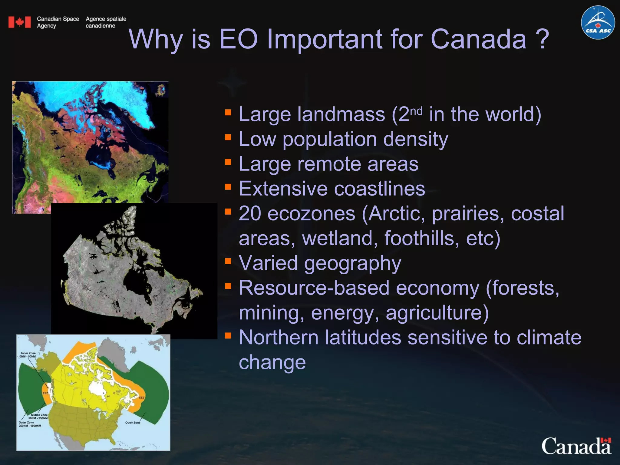
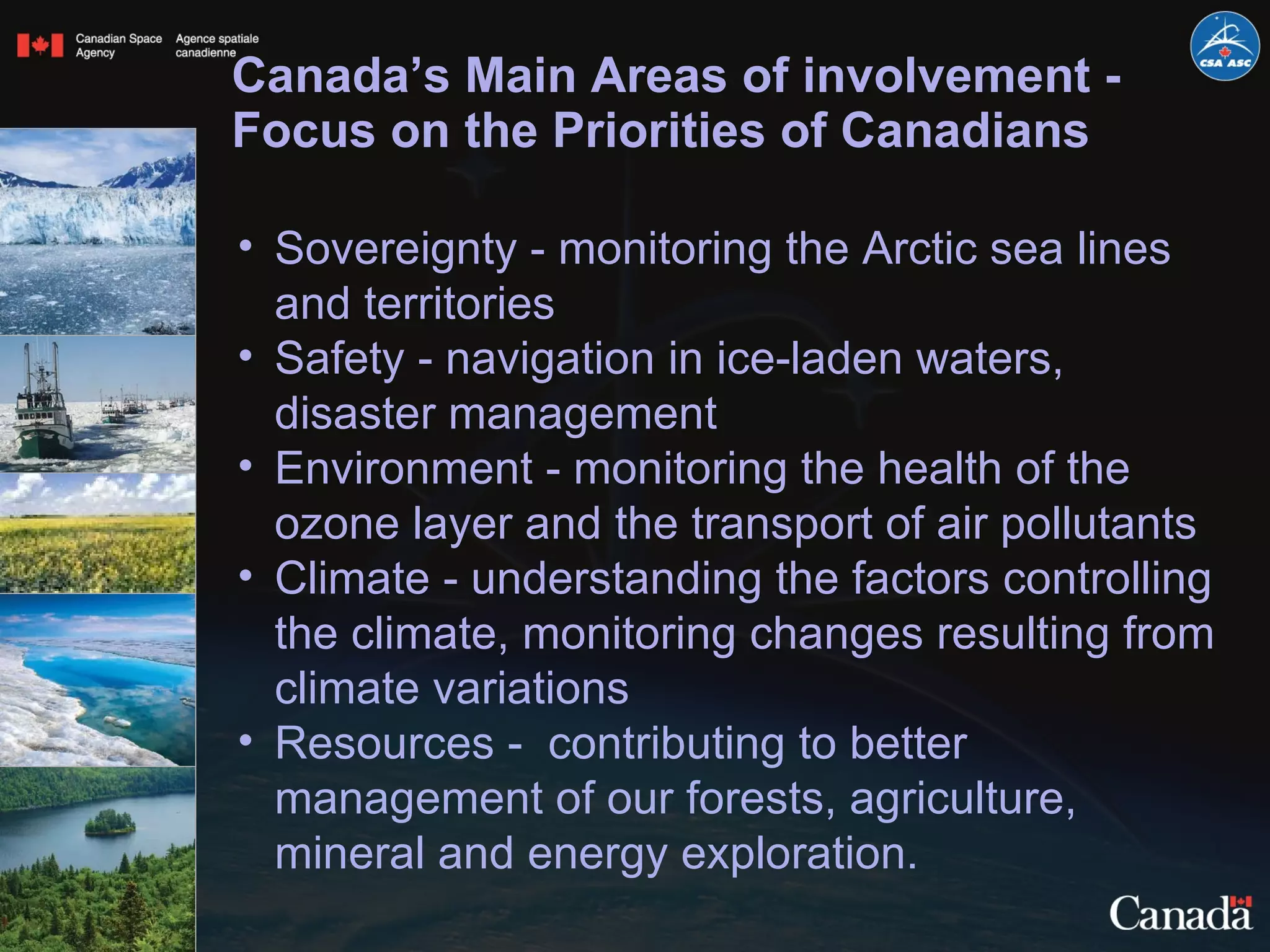
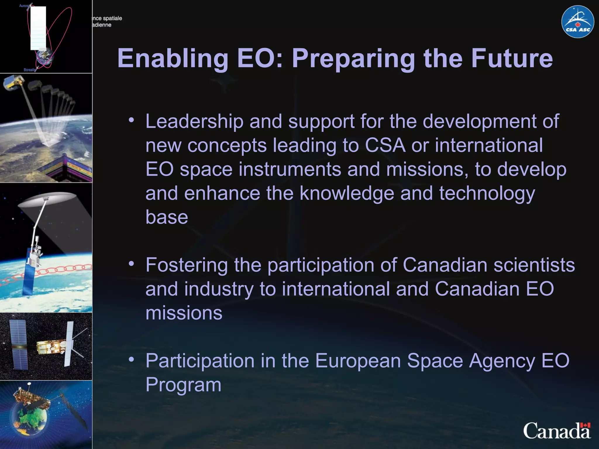
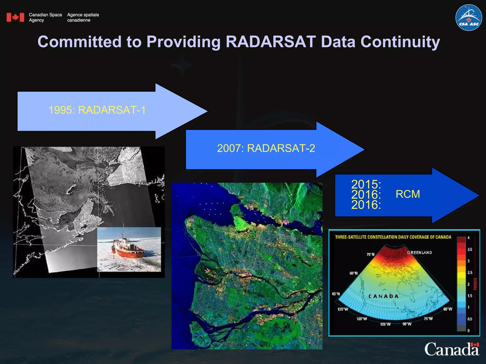
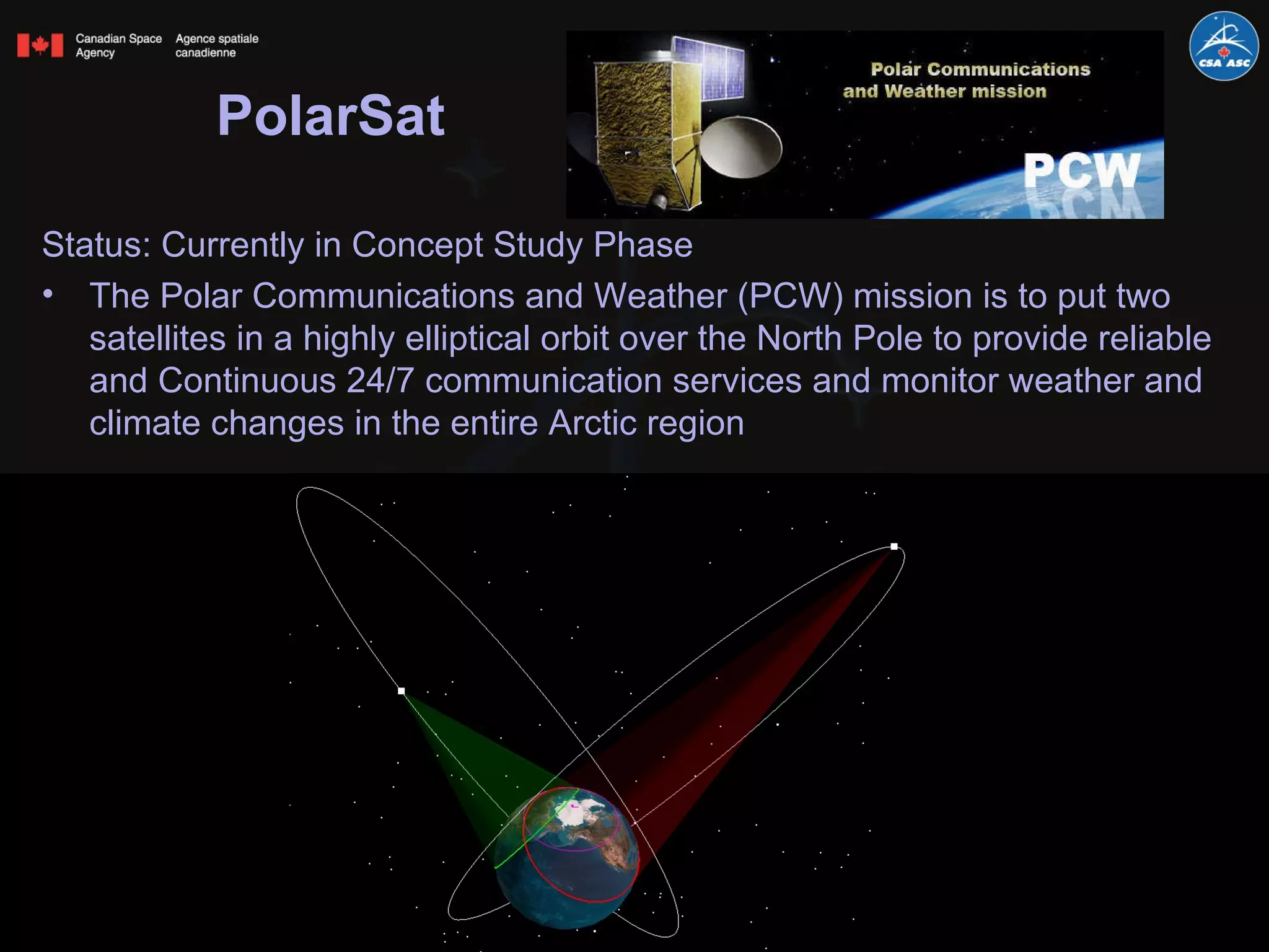
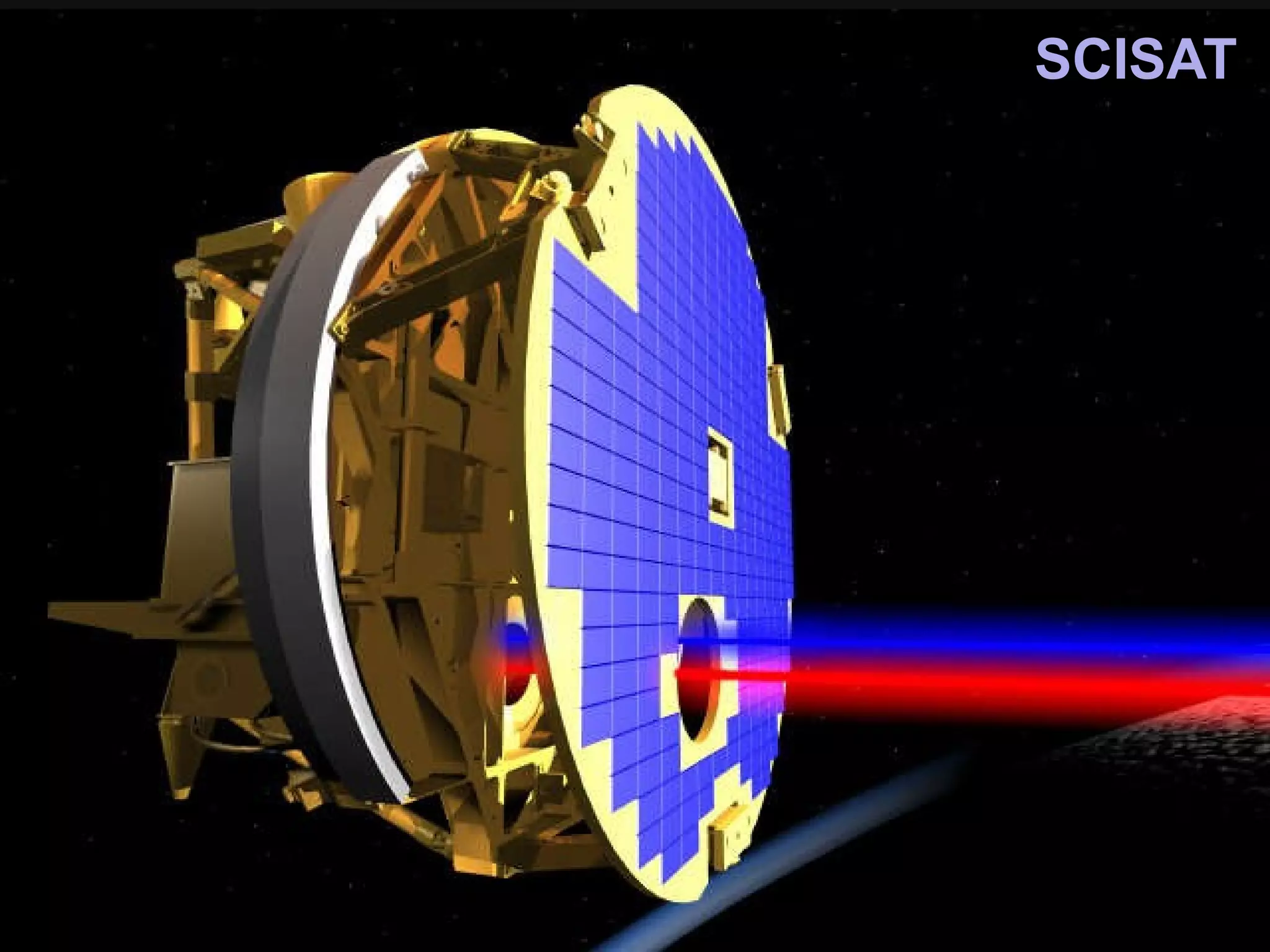
SlideShare a Scribd company logo
The Evolution of Earth Observation in Canada -  A Perspective Luc Brûlé Director General, Space Utilization Canadian Space Agency [email_address] IGARSS 2011 Vancouver, Canada ● July 24-29, 2011
[object Object],[object Object],[object Object],[object Object]
Prevailing trends  ,[object Object],[object Object],[object Object],[object Object],[object Object],[object Object]
“… to promote the peaceful use and development of space, to advance the knowledge of space through science and to ensure that space science and technology provide social and economic benefits for Canadians.”  Canadian Space Agency Mandate
Structure
[object Object],[object Object],[object Object],[object Object],[object Object],[object Object],[object Object],[object Object],Why is EO Important for Canada ?
Canada’s Main Areas of involvement - Focus on the Priorities of Canadians ,[object Object],[object Object],[object Object],[object Object],[object Object]
What is the CSA doing in EO ? ,[object Object],[object Object],[object Object]
Enabling EO: Preparing the Future ,[object Object],[object Object],[object Object]
Committed to Providing RADARSAT Data Continuity 1995: RADARSAT-1 2007: RADARSAT-2 2015: 2016:  2016: RCM
International Charter 2011 Earthquake in Japan Flood detection with RADARSAT-2 crisis image  (March 12, 2011) and  RADARSAT-1 pre-crisis image (March 26, 2006)
RADARSAT Constellation (RCM) ,[object Object],[object Object],[object Object],[object Object],[object Object],[object Object]
[object Object],[object Object],[object Object],[object Object],[object Object],[object Object],Synergy Sentinel-1 / RCM
PolarSat ,[object Object],[object Object]
SCISAT
Other Earth-observation satellites ,[object Object],[object Object],[object Object],[object Object],[object Object],[object Object],[object Object],[object Object]
EO Applications Programs: Promoting the Use of EO Data ,[object Object],[object Object],[object Object],[object Object]
What does the future hold for Canada? ,[object Object],[object Object],[object Object]
Merci  Thank you  どうも ありがとう

More Related Content

What's hot

Locate17 and ISDE10 Keynote_S Ramage GEO April 2017
Locate17 and ISDE10 Keynote_S Ramage GEO April 2017Locate17 and ISDE10 Keynote_S Ramage GEO April 2017
Locate17 and ISDE10 Keynote_S Ramage GEO April 2017
Steven Ramage
 
S Ramage GEO UN-GGIM HLF Mexico Nov 2017
S Ramage GEO UN-GGIM HLF Mexico Nov 2017S Ramage GEO UN-GGIM HLF Mexico Nov 2017
S Ramage GEO UN-GGIM HLF Mexico Nov 2017
Steven Ramage
 
Data for the Blue Future: New Collaborations for Progress
Data for the Blue Future: New Collaborations for ProgressData for the Blue Future: New Collaborations for Progress
Data for the Blue Future: New Collaborations for Progress
Dawn Wright
 
Mohammad_Term_Paper_S2013
Mohammad_Term_Paper_S2013Mohammad_Term_Paper_S2013
Mohammad_Term_Paper_S2013Rokib Rahman
 
Moderate_resolution_GEC
Moderate_resolution_GECModerate_resolution_GEC
Moderate_resolution_GECKenneth Kay
 
S Ramage GEO_IEOS Nov 2017
S Ramage GEO_IEOS Nov 2017S Ramage GEO_IEOS Nov 2017
S Ramage GEO_IEOS Nov 2017
Steven Ramage
 
Progress of land ecosystem studies with geo information and space technology ...
Progress of land ecosystem studies with geo information and space technology ...Progress of land ecosystem studies with geo information and space technology ...
Progress of land ecosystem studies with geo information and space technology ...
Institute of Space Knowledge Development
 
Habib-IGARSS 2011 FR3-TR10.pptx
Habib-IGARSS 2011 FR3-TR10.pptxHabib-IGARSS 2011 FR3-TR10.pptx
Habib-IGARSS 2011 FR3-TR10.pptxgrssieee
 
Gi science discipline_foloo
Gi science discipline_folooGi science discipline_foloo
Gi science discipline_foloooloofrank
 
buckley-smith igarss2011.pptx
buckley-smith igarss2011.pptxbuckley-smith igarss2011.pptx
buckley-smith igarss2011.pptxgrssieee
 
WE4.L10.1: OPERATIONAL ENVIRONMENTAL DATA IN 2010: CONNECTING GLOBAL AND LOCA...
WE4.L10.1: OPERATIONAL ENVIRONMENTAL DATA IN 2010: CONNECTING GLOBAL AND LOCA...WE4.L10.1: OPERATIONAL ENVIRONMENTAL DATA IN 2010: CONNECTING GLOBAL AND LOCA...
WE4.L10.1: OPERATIONAL ENVIRONMENTAL DATA IN 2010: CONNECTING GLOBAL AND LOCA...grssieee
 
Pan_European and pan-African Early Warning on Floods and Droughts: From the E...
Pan_European and pan-African Early Warning on Floods and Droughts: From the E...Pan_European and pan-African Early Warning on Floods and Droughts: From the E...
Pan_European and pan-African Early Warning on Floods and Droughts: From the E...
Global Risk Forum GRFDavos
 
eMerges - Terra Cognita 2006 Workshop (ISWC)
eMerges - Terra Cognita 2006 Workshop (ISWC)eMerges - Terra Cognita 2006 Workshop (ISWC)
eMerges - Terra Cognita 2006 Workshop (ISWC)
Vlad Tanasescu
 
Better Hackathon 2020 ETHZ - Comparing Static And Dynamic Effects Of Earthquakes
Better Hackathon 2020 ETHZ - Comparing Static And Dynamic Effects Of EarthquakesBetter Hackathon 2020 ETHZ - Comparing Static And Dynamic Effects Of Earthquakes
Better Hackathon 2020 ETHZ - Comparing Static And Dynamic Effects Of Earthquakes
PRBETTER
 
IMED 2018: An intro to Remote Sensing and Machine Learning
IMED 2018: An intro to Remote Sensing and Machine LearningIMED 2018: An intro to Remote Sensing and Machine Learning
IMED 2018: An intro to Remote Sensing and Machine Learning
Louisa Diggs
 
State of U.S. Space Policy: Implications for Land Management Markets
State of U.S. Space Policy: Implications for Land Management MarketsState of U.S. Space Policy: Implications for Land Management Markets
State of U.S. Space Policy: Implications for Land Management Markets
Penn Institute for Urban Research
 
C0.5: CEOS and Oceans - Chu Ishida, Alex Held
C0.5: CEOS and Oceans - Chu Ishida, Alex HeldC0.5: CEOS and Oceans - Chu Ishida, Alex Held
C0.5: CEOS and Oceans - Chu Ishida, Alex Held
Blue Planet Symposium
 
Sieusoil teaser #26
Sieusoil teaser #26Sieusoil teaser #26
Sieusoil teaser #26
SIEUSOIL
 
Geospatial intelligence satellite applications catapult pdf - july 23 2019
Geospatial intelligence   satellite applications catapult pdf - july 23 2019Geospatial intelligence   satellite applications catapult pdf - july 23 2019
Geospatial intelligence satellite applications catapult pdf - july 23 2019
Peter Bloomfield
 

What's hot (20)

Locate17 and ISDE10 Keynote_S Ramage GEO April 2017
Locate17 and ISDE10 Keynote_S Ramage GEO April 2017Locate17 and ISDE10 Keynote_S Ramage GEO April 2017
Locate17 and ISDE10 Keynote_S Ramage GEO April 2017
 
S Ramage GEO UN-GGIM HLF Mexico Nov 2017
S Ramage GEO UN-GGIM HLF Mexico Nov 2017S Ramage GEO UN-GGIM HLF Mexico Nov 2017
S Ramage GEO UN-GGIM HLF Mexico Nov 2017
 
Data for the Blue Future: New Collaborations for Progress
Data for the Blue Future: New Collaborations for ProgressData for the Blue Future: New Collaborations for Progress
Data for the Blue Future: New Collaborations for Progress
 
Mohammad_Term_Paper_S2013
Mohammad_Term_Paper_S2013Mohammad_Term_Paper_S2013
Mohammad_Term_Paper_S2013
 
Moderate_resolution_GEC
Moderate_resolution_GECModerate_resolution_GEC
Moderate_resolution_GEC
 
S Ramage GEO_IEOS Nov 2017
S Ramage GEO_IEOS Nov 2017S Ramage GEO_IEOS Nov 2017
S Ramage GEO_IEOS Nov 2017
 
Progress of land ecosystem studies with geo information and space technology ...
Progress of land ecosystem studies with geo information and space technology ...Progress of land ecosystem studies with geo information and space technology ...
Progress of land ecosystem studies with geo information and space technology ...
 
Habib-IGARSS 2011 FR3-TR10.pptx
Habib-IGARSS 2011 FR3-TR10.pptxHabib-IGARSS 2011 FR3-TR10.pptx
Habib-IGARSS 2011 FR3-TR10.pptx
 
Gi science discipline_foloo
Gi science discipline_folooGi science discipline_foloo
Gi science discipline_foloo
 
buckley-smith igarss2011.pptx
buckley-smith igarss2011.pptxbuckley-smith igarss2011.pptx
buckley-smith igarss2011.pptx
 
WE4.L10.1: OPERATIONAL ENVIRONMENTAL DATA IN 2010: CONNECTING GLOBAL AND LOCA...
WE4.L10.1: OPERATIONAL ENVIRONMENTAL DATA IN 2010: CONNECTING GLOBAL AND LOCA...WE4.L10.1: OPERATIONAL ENVIRONMENTAL DATA IN 2010: CONNECTING GLOBAL AND LOCA...
WE4.L10.1: OPERATIONAL ENVIRONMENTAL DATA IN 2010: CONNECTING GLOBAL AND LOCA...
 
Pan_European and pan-African Early Warning on Floods and Droughts: From the E...
Pan_European and pan-African Early Warning on Floods and Droughts: From the E...Pan_European and pan-African Early Warning on Floods and Droughts: From the E...
Pan_European and pan-African Early Warning on Floods and Droughts: From the E...
 
eMerges - Terra Cognita 2006 Workshop (ISWC)
eMerges - Terra Cognita 2006 Workshop (ISWC)eMerges - Terra Cognita 2006 Workshop (ISWC)
eMerges - Terra Cognita 2006 Workshop (ISWC)
 
surveying paper
surveying papersurveying paper
surveying paper
 
Better Hackathon 2020 ETHZ - Comparing Static And Dynamic Effects Of Earthquakes
Better Hackathon 2020 ETHZ - Comparing Static And Dynamic Effects Of EarthquakesBetter Hackathon 2020 ETHZ - Comparing Static And Dynamic Effects Of Earthquakes
Better Hackathon 2020 ETHZ - Comparing Static And Dynamic Effects Of Earthquakes
 
IMED 2018: An intro to Remote Sensing and Machine Learning
IMED 2018: An intro to Remote Sensing and Machine LearningIMED 2018: An intro to Remote Sensing and Machine Learning
IMED 2018: An intro to Remote Sensing and Machine Learning
 
State of U.S. Space Policy: Implications for Land Management Markets
State of U.S. Space Policy: Implications for Land Management MarketsState of U.S. Space Policy: Implications for Land Management Markets
State of U.S. Space Policy: Implications for Land Management Markets
 
C0.5: CEOS and Oceans - Chu Ishida, Alex Held
C0.5: CEOS and Oceans - Chu Ishida, Alex HeldC0.5: CEOS and Oceans - Chu Ishida, Alex Held
C0.5: CEOS and Oceans - Chu Ishida, Alex Held
 
Sieusoil teaser #26
Sieusoil teaser #26Sieusoil teaser #26
Sieusoil teaser #26
 
Geospatial intelligence satellite applications catapult pdf - july 23 2019
Geospatial intelligence   satellite applications catapult pdf - july 23 2019Geospatial intelligence   satellite applications catapult pdf - july 23 2019
Geospatial intelligence satellite applications catapult pdf - july 23 2019
 

Similar to IGARSS 11 Plenary Luc Brule_final.ppt

AAS National Conference 2008: Graham Gibbs
AAS National Conference 2008: Graham GibbsAAS National Conference 2008: Graham Gibbs
AAS National Conference 2008: Graham Gibbs
American Astronautical Society
 
Strengthening monitoring of the state of the Earth
Strengthening monitoring of the state of the EarthStrengthening monitoring of the state of the Earth
Strengthening monitoring of the state of the Earth
Christina Parmionova
 
Copernicus Status
Copernicus Status Copernicus Status
Copernicus Status
The European GNSS Agency (GSA)
 
SC7 Workshop 2: Space Data for Secure Societies
SC7 Workshop 2: Space Data for Secure SocietiesSC7 Workshop 2: Space Data for Secure Societies
SC7 Workshop 2: Space Data for Secure Societies
BigData_Europe
 
Describe and explain satellite remote sensing mission for monitoring.pdf
Describe and explain satellite remote sensing mission for monitoring.pdfDescribe and explain satellite remote sensing mission for monitoring.pdf
Describe and explain satellite remote sensing mission for monitoring.pdf
alshaikhkhanzariarts
 
Earth Science and Applications from Space
Earth Science and Applications from SpaceEarth Science and Applications from Space
Earth Science and Applications from Space
Art Charo
 
NASA Keynote Presentation - Monday Conservation Forum
NASA Keynote Presentation - Monday Conservation ForumNASA Keynote Presentation - Monday Conservation Forum
NASA Keynote Presentation - Monday Conservation Forum
National Association of Conservation Districts
 
Satellite applications satellite applicationssatellite applications
Satellite applications satellite applicationssatellite applicationsSatellite applications satellite applicationssatellite applications
Satellite applications satellite applicationssatellite applications
nader babo
 
The NASA Western Water Applications Office - Indrani C. Graczyk
The NASA Western Water Applications Office - Indrani C. GraczykThe NASA Western Water Applications Office - Indrani C. Graczyk
The NASA Western Water Applications Office - Indrani C. Graczyk
TWCA
 
FY 2013 R&D REPORT January 6 2014 - National Aeronautics and Space Administra...
FY 2013 R&D REPORT January 6 2014 - National Aeronautics and Space Administra...FY 2013 R&D REPORT January 6 2014 - National Aeronautics and Space Administra...
FY 2013 R&D REPORT January 6 2014 - National Aeronautics and Space Administra...
Lyle Birkey
 
NASA Advancing Climate Strategy 2023
 NASA Advancing Climate Strategy 2023 NASA Advancing Climate Strategy 2023
NASA Advancing Climate Strategy 2023
Dr. Pankaj Dhussa
 
60 Years of Successful Scientific Collaboration on Weather, Climate and Water...
60 Years of Successful Scientific Collaboration on Weather, Climate and Water...60 Years of Successful Scientific Collaboration on Weather, Climate and Water...
60 Years of Successful Scientific Collaboration on Weather, Climate and Water...
Tim Goos
 
AAS National Conference 2008: Mike Freilich
AAS National Conference 2008: Mike FreilichAAS National Conference 2008: Mike Freilich
AAS National Conference 2008: Mike Freilich
American Astronautical Society
 
Inter fellous freilich
Inter fellous freilichInter fellous freilich
Inter fellous freilichNASAPMC
 
Inter fellous freilich
Inter fellous freilichInter fellous freilich
Inter fellous freilichNASAPMC
 
Day 1 9 rupa kumar kolli, wmo, arrcc-carissa workshop
Day 1 9 rupa kumar kolli, wmo, arrcc-carissa workshopDay 1 9 rupa kumar kolli, wmo, arrcc-carissa workshop
Day 1 9 rupa kumar kolli, wmo, arrcc-carissa workshop
ICIMOD
 
CLIM Program: Remote Sensing Workshop, Satellites and Stovepipes - Jay Morris...
CLIM Program: Remote Sensing Workshop, Satellites and Stovepipes - Jay Morris...CLIM Program: Remote Sensing Workshop, Satellites and Stovepipes - Jay Morris...
CLIM Program: Remote Sensing Workshop, Satellites and Stovepipes - Jay Morris...
The Statistical and Applied Mathematical Sciences Institute
 
Multi-sensor Improved Sea Surface Temperatures Project
Multi-sensor Improved Sea Surface Temperatures ProjectMulti-sensor Improved Sea Surface Temperatures Project
Multi-sensor Improved Sea Surface Temperatures Project
Chelle Gentemann
 
NPOESS Transition to the Joint Polar Satellite System (JPSS) and Defense Weat...
NPOESS Transition to the Joint Polar Satellite System (JPSS) and Defense Weat...NPOESS Transition to the Joint Polar Satellite System (JPSS) and Defense Weat...
NPOESS Transition to the Joint Polar Satellite System (JPSS) and Defense Weat...grssieee
 
FUNDING FOR ENVIRONMENTAL RESEARCH AND DEVELOPMENT BY NASA
FUNDING FOR  ENVIRONMENTAL RESEARCH AND DEVELOPMENT  BY NASA FUNDING FOR  ENVIRONMENTAL RESEARCH AND DEVELOPMENT  BY NASA
FUNDING FOR ENVIRONMENTAL RESEARCH AND DEVELOPMENT BY NASA
Lyle Birkey
 

Similar to IGARSS 11 Plenary Luc Brule_final.ppt (20)

AAS National Conference 2008: Graham Gibbs
AAS National Conference 2008: Graham GibbsAAS National Conference 2008: Graham Gibbs
AAS National Conference 2008: Graham Gibbs
 
Strengthening monitoring of the state of the Earth
Strengthening monitoring of the state of the EarthStrengthening monitoring of the state of the Earth
Strengthening monitoring of the state of the Earth
 
Copernicus Status
Copernicus Status Copernicus Status
Copernicus Status
 
SC7 Workshop 2: Space Data for Secure Societies
SC7 Workshop 2: Space Data for Secure SocietiesSC7 Workshop 2: Space Data for Secure Societies
SC7 Workshop 2: Space Data for Secure Societies
 
Describe and explain satellite remote sensing mission for monitoring.pdf
Describe and explain satellite remote sensing mission for monitoring.pdfDescribe and explain satellite remote sensing mission for monitoring.pdf
Describe and explain satellite remote sensing mission for monitoring.pdf
 
Earth Science and Applications from Space
Earth Science and Applications from SpaceEarth Science and Applications from Space
Earth Science and Applications from Space
 
NASA Keynote Presentation - Monday Conservation Forum
NASA Keynote Presentation - Monday Conservation ForumNASA Keynote Presentation - Monday Conservation Forum
NASA Keynote Presentation - Monday Conservation Forum
 
Satellite applications satellite applicationssatellite applications
Satellite applications satellite applicationssatellite applicationsSatellite applications satellite applicationssatellite applications
Satellite applications satellite applicationssatellite applications
 
The NASA Western Water Applications Office - Indrani C. Graczyk
The NASA Western Water Applications Office - Indrani C. GraczykThe NASA Western Water Applications Office - Indrani C. Graczyk
The NASA Western Water Applications Office - Indrani C. Graczyk
 
FY 2013 R&D REPORT January 6 2014 - National Aeronautics and Space Administra...
FY 2013 R&D REPORT January 6 2014 - National Aeronautics and Space Administra...FY 2013 R&D REPORT January 6 2014 - National Aeronautics and Space Administra...
FY 2013 R&D REPORT January 6 2014 - National Aeronautics and Space Administra...
 
NASA Advancing Climate Strategy 2023
 NASA Advancing Climate Strategy 2023 NASA Advancing Climate Strategy 2023
NASA Advancing Climate Strategy 2023
 
60 Years of Successful Scientific Collaboration on Weather, Climate and Water...
60 Years of Successful Scientific Collaboration on Weather, Climate and Water...60 Years of Successful Scientific Collaboration on Weather, Climate and Water...
60 Years of Successful Scientific Collaboration on Weather, Climate and Water...
 
AAS National Conference 2008: Mike Freilich
AAS National Conference 2008: Mike FreilichAAS National Conference 2008: Mike Freilich
AAS National Conference 2008: Mike Freilich
 
Inter fellous freilich
Inter fellous freilichInter fellous freilich
Inter fellous freilich
 
Inter fellous freilich
Inter fellous freilichInter fellous freilich
Inter fellous freilich
 
Day 1 9 rupa kumar kolli, wmo, arrcc-carissa workshop
Day 1 9 rupa kumar kolli, wmo, arrcc-carissa workshopDay 1 9 rupa kumar kolli, wmo, arrcc-carissa workshop
Day 1 9 rupa kumar kolli, wmo, arrcc-carissa workshop
 
CLIM Program: Remote Sensing Workshop, Satellites and Stovepipes - Jay Morris...
CLIM Program: Remote Sensing Workshop, Satellites and Stovepipes - Jay Morris...CLIM Program: Remote Sensing Workshop, Satellites and Stovepipes - Jay Morris...
CLIM Program: Remote Sensing Workshop, Satellites and Stovepipes - Jay Morris...
 
Multi-sensor Improved Sea Surface Temperatures Project
Multi-sensor Improved Sea Surface Temperatures ProjectMulti-sensor Improved Sea Surface Temperatures Project
Multi-sensor Improved Sea Surface Temperatures Project
 
NPOESS Transition to the Joint Polar Satellite System (JPSS) and Defense Weat...
NPOESS Transition to the Joint Polar Satellite System (JPSS) and Defense Weat...NPOESS Transition to the Joint Polar Satellite System (JPSS) and Defense Weat...
NPOESS Transition to the Joint Polar Satellite System (JPSS) and Defense Weat...
 
FUNDING FOR ENVIRONMENTAL RESEARCH AND DEVELOPMENT BY NASA
FUNDING FOR  ENVIRONMENTAL RESEARCH AND DEVELOPMENT  BY NASA FUNDING FOR  ENVIRONMENTAL RESEARCH AND DEVELOPMENT  BY NASA
FUNDING FOR ENVIRONMENTAL RESEARCH AND DEVELOPMENT BY NASA
 

More from grssieee

Tangent height accuracy of Superconducting Submillimeter-Wave Limb-Emission S...
Tangent height accuracy of Superconducting Submillimeter-Wave Limb-Emission S...Tangent height accuracy of Superconducting Submillimeter-Wave Limb-Emission S...
Tangent height accuracy of Superconducting Submillimeter-Wave Limb-Emission S...grssieee
 
SEGMENTATION OF POLARIMETRIC SAR DATA WITH A MULTI-TEXTURE PRODUCT MODEL
SEGMENTATION OF POLARIMETRIC SAR DATA WITH A MULTI-TEXTURE PRODUCT MODELSEGMENTATION OF POLARIMETRIC SAR DATA WITH A MULTI-TEXTURE PRODUCT MODEL
SEGMENTATION OF POLARIMETRIC SAR DATA WITH A MULTI-TEXTURE PRODUCT MODELgrssieee
 
TWO-POINT STATISTIC OF POLARIMETRIC SAR DATA TWO-POINT STATISTIC OF POLARIMET...
TWO-POINT STATISTIC OF POLARIMETRIC SAR DATA TWO-POINT STATISTIC OF POLARIMET...TWO-POINT STATISTIC OF POLARIMETRIC SAR DATA TWO-POINT STATISTIC OF POLARIMET...
TWO-POINT STATISTIC OF POLARIMETRIC SAR DATA TWO-POINT STATISTIC OF POLARIMET...grssieee
 
THE SENTINEL-1 MISSION AND ITS APPLICATION CAPABILITIES
THE SENTINEL-1 MISSION AND ITS APPLICATION CAPABILITIESTHE SENTINEL-1 MISSION AND ITS APPLICATION CAPABILITIES
THE SENTINEL-1 MISSION AND ITS APPLICATION CAPABILITIESgrssieee
 
GMES SPACE COMPONENT:PROGRAMMATIC STATUS
GMES SPACE COMPONENT:PROGRAMMATIC STATUSGMES SPACE COMPONENT:PROGRAMMATIC STATUS
GMES SPACE COMPONENT:PROGRAMMATIC STATUSgrssieee
 
PROGRESSES OF DEVELOPMENT OF CFOSAT SCATTEROMETER
PROGRESSES OF DEVELOPMENT OF CFOSAT SCATTEROMETERPROGRESSES OF DEVELOPMENT OF CFOSAT SCATTEROMETER
PROGRESSES OF DEVELOPMENT OF CFOSAT SCATTEROMETERgrssieee
 
DEVELOPMENT OF ALGORITHMS AND PRODUCTS FOR SUPPORTING THE ITALIAN HYPERSPECTR...
DEVELOPMENT OF ALGORITHMS AND PRODUCTS FOR SUPPORTING THE ITALIAN HYPERSPECTR...DEVELOPMENT OF ALGORITHMS AND PRODUCTS FOR SUPPORTING THE ITALIAN HYPERSPECTR...
DEVELOPMENT OF ALGORITHMS AND PRODUCTS FOR SUPPORTING THE ITALIAN HYPERSPECTR...grssieee
 
EO-1/HYPERION: NEARING TWELVE YEARS OF SUCCESSFUL MISSION SCIENCE OPERATION A...
EO-1/HYPERION: NEARING TWELVE YEARS OF SUCCESSFUL MISSION SCIENCE OPERATION A...EO-1/HYPERION: NEARING TWELVE YEARS OF SUCCESSFUL MISSION SCIENCE OPERATION A...
EO-1/HYPERION: NEARING TWELVE YEARS OF SUCCESSFUL MISSION SCIENCE OPERATION A...grssieee
 
test 34mb wo animations
test  34mb wo animationstest  34mb wo animations
test 34mb wo animationsgrssieee
 
2011_Fox_Tax_Worksheets.pdf
2011_Fox_Tax_Worksheets.pdf2011_Fox_Tax_Worksheets.pdf
2011_Fox_Tax_Worksheets.pdfgrssieee
 
DLR open house
DLR open houseDLR open house
DLR open housegrssieee
 
DLR open house
DLR open houseDLR open house
DLR open housegrssieee
 
DLR open house
DLR open houseDLR open house
DLR open housegrssieee
 
Tana_IGARSS2011.ppt
Tana_IGARSS2011.pptTana_IGARSS2011.ppt
Tana_IGARSS2011.pptgrssieee
 
Solaro_IGARSS_2011.ppt
Solaro_IGARSS_2011.pptSolaro_IGARSS_2011.ppt
Solaro_IGARSS_2011.pptgrssieee
 

More from grssieee (20)

Tangent height accuracy of Superconducting Submillimeter-Wave Limb-Emission S...
Tangent height accuracy of Superconducting Submillimeter-Wave Limb-Emission S...Tangent height accuracy of Superconducting Submillimeter-Wave Limb-Emission S...
Tangent height accuracy of Superconducting Submillimeter-Wave Limb-Emission S...
 
SEGMENTATION OF POLARIMETRIC SAR DATA WITH A MULTI-TEXTURE PRODUCT MODEL
SEGMENTATION OF POLARIMETRIC SAR DATA WITH A MULTI-TEXTURE PRODUCT MODELSEGMENTATION OF POLARIMETRIC SAR DATA WITH A MULTI-TEXTURE PRODUCT MODEL
SEGMENTATION OF POLARIMETRIC SAR DATA WITH A MULTI-TEXTURE PRODUCT MODEL
 
TWO-POINT STATISTIC OF POLARIMETRIC SAR DATA TWO-POINT STATISTIC OF POLARIMET...
TWO-POINT STATISTIC OF POLARIMETRIC SAR DATA TWO-POINT STATISTIC OF POLARIMET...TWO-POINT STATISTIC OF POLARIMETRIC SAR DATA TWO-POINT STATISTIC OF POLARIMET...
TWO-POINT STATISTIC OF POLARIMETRIC SAR DATA TWO-POINT STATISTIC OF POLARIMET...
 
THE SENTINEL-1 MISSION AND ITS APPLICATION CAPABILITIES
THE SENTINEL-1 MISSION AND ITS APPLICATION CAPABILITIESTHE SENTINEL-1 MISSION AND ITS APPLICATION CAPABILITIES
THE SENTINEL-1 MISSION AND ITS APPLICATION CAPABILITIES
 
GMES SPACE COMPONENT:PROGRAMMATIC STATUS
GMES SPACE COMPONENT:PROGRAMMATIC STATUSGMES SPACE COMPONENT:PROGRAMMATIC STATUS
GMES SPACE COMPONENT:PROGRAMMATIC STATUS
 
PROGRESSES OF DEVELOPMENT OF CFOSAT SCATTEROMETER
PROGRESSES OF DEVELOPMENT OF CFOSAT SCATTEROMETERPROGRESSES OF DEVELOPMENT OF CFOSAT SCATTEROMETER
PROGRESSES OF DEVELOPMENT OF CFOSAT SCATTEROMETER
 
DEVELOPMENT OF ALGORITHMS AND PRODUCTS FOR SUPPORTING THE ITALIAN HYPERSPECTR...
DEVELOPMENT OF ALGORITHMS AND PRODUCTS FOR SUPPORTING THE ITALIAN HYPERSPECTR...DEVELOPMENT OF ALGORITHMS AND PRODUCTS FOR SUPPORTING THE ITALIAN HYPERSPECTR...
DEVELOPMENT OF ALGORITHMS AND PRODUCTS FOR SUPPORTING THE ITALIAN HYPERSPECTR...
 
EO-1/HYPERION: NEARING TWELVE YEARS OF SUCCESSFUL MISSION SCIENCE OPERATION A...
EO-1/HYPERION: NEARING TWELVE YEARS OF SUCCESSFUL MISSION SCIENCE OPERATION A...EO-1/HYPERION: NEARING TWELVE YEARS OF SUCCESSFUL MISSION SCIENCE OPERATION A...
EO-1/HYPERION: NEARING TWELVE YEARS OF SUCCESSFUL MISSION SCIENCE OPERATION A...
 
EO-1/HYPERION: NEARING TWELVE YEARS OF SUCCESSFUL MISSION SCIENCE OPERATION A...
EO-1/HYPERION: NEARING TWELVE YEARS OF SUCCESSFUL MISSION SCIENCE OPERATION A...EO-1/HYPERION: NEARING TWELVE YEARS OF SUCCESSFUL MISSION SCIENCE OPERATION A...
EO-1/HYPERION: NEARING TWELVE YEARS OF SUCCESSFUL MISSION SCIENCE OPERATION A...
 
Test
TestTest
Test
 
test 34mb wo animations
test  34mb wo animationstest  34mb wo animations
test 34mb wo animations
 
Test 70MB
Test 70MBTest 70MB
Test 70MB
 
Test 70MB
Test 70MBTest 70MB
Test 70MB
 
2011_Fox_Tax_Worksheets.pdf
2011_Fox_Tax_Worksheets.pdf2011_Fox_Tax_Worksheets.pdf
2011_Fox_Tax_Worksheets.pdf
 
DLR open house
DLR open houseDLR open house
DLR open house
 
DLR open house
DLR open houseDLR open house
DLR open house
 
DLR open house
DLR open houseDLR open house
DLR open house
 
Tana_IGARSS2011.ppt
Tana_IGARSS2011.pptTana_IGARSS2011.ppt
Tana_IGARSS2011.ppt
 
Solaro_IGARSS_2011.ppt
Solaro_IGARSS_2011.pptSolaro_IGARSS_2011.ppt
Solaro_IGARSS_2011.ppt
 

Recently uploaded

Key Trends Shaping the Future of Infrastructure.pdf
Key Trends Shaping the Future of Infrastructure.pdfKey Trends Shaping the Future of Infrastructure.pdf
Key Trends Shaping the Future of Infrastructure.pdf
Cheryl Hung
 
The Future of Platform Engineering
The Future of Platform EngineeringThe Future of Platform Engineering
The Future of Platform Engineering
Jemma Hussein Allen
 
Mission to Decommission: Importance of Decommissioning Products to Increase E...
Mission to Decommission: Importance of Decommissioning Products to Increase E...Mission to Decommission: Importance of Decommissioning Products to Increase E...
Mission to Decommission: Importance of Decommissioning Products to Increase E...
Product School
 
UiPath Test Automation using UiPath Test Suite series, part 3
UiPath Test Automation using UiPath Test Suite series, part 3UiPath Test Automation using UiPath Test Suite series, part 3
UiPath Test Automation using UiPath Test Suite series, part 3
DianaGray10
 
Slack (or Teams) Automation for Bonterra Impact Management (fka Social Soluti...
Slack (or Teams) Automation for Bonterra Impact Management (fka Social Soluti...Slack (or Teams) Automation for Bonterra Impact Management (fka Social Soluti...
Slack (or Teams) Automation for Bonterra Impact Management (fka Social Soluti...
Jeffrey Haguewood
 
Epistemic Interaction - tuning interfaces to provide information for AI support
Epistemic Interaction - tuning interfaces to provide information for AI supportEpistemic Interaction - tuning interfaces to provide information for AI support
Epistemic Interaction - tuning interfaces to provide information for AI support
Alan Dix
 
FIDO Alliance Osaka Seminar: FIDO Security Aspects.pdf
FIDO Alliance Osaka Seminar: FIDO Security Aspects.pdfFIDO Alliance Osaka Seminar: FIDO Security Aspects.pdf
FIDO Alliance Osaka Seminar: FIDO Security Aspects.pdf
FIDO Alliance
 
Connector Corner: Automate dynamic content and events by pushing a button
Connector Corner: Automate dynamic content and events by pushing a buttonConnector Corner: Automate dynamic content and events by pushing a button
Connector Corner: Automate dynamic content and events by pushing a button
DianaGray10
 
Encryption in Microsoft 365 - ExpertsLive Netherlands 2024
Encryption in Microsoft 365 - ExpertsLive Netherlands 2024Encryption in Microsoft 365 - ExpertsLive Netherlands 2024
Encryption in Microsoft 365 - ExpertsLive Netherlands 2024
Albert Hoitingh
 
Transcript: Selling digital books in 2024: Insights from industry leaders - T...
Transcript: Selling digital books in 2024: Insights from industry leaders - T...Transcript: Selling digital books in 2024: Insights from industry leaders - T...
Transcript: Selling digital books in 2024: Insights from industry leaders - T...
BookNet Canada
 
Kubernetes & AI - Beauty and the Beast !?! @KCD Istanbul 2024
Kubernetes & AI - Beauty and the Beast !?! @KCD Istanbul 2024Kubernetes & AI - Beauty and the Beast !?! @KCD Istanbul 2024
Kubernetes & AI - Beauty and the Beast !?! @KCD Istanbul 2024
Tobias Schneck
 
JMeter webinar - integration with InfluxDB and Grafana
JMeter webinar - integration with InfluxDB and GrafanaJMeter webinar - integration with InfluxDB and Grafana
JMeter webinar - integration with InfluxDB and Grafana
RTTS
 
Designing Great Products: The Power of Design and Leadership by Chief Designe...
Designing Great Products: The Power of Design and Leadership by Chief Designe...Designing Great Products: The Power of Design and Leadership by Chief Designe...
Designing Great Products: The Power of Design and Leadership by Chief Designe...
Product School
 
FIDO Alliance Osaka Seminar: The WebAuthn API and Discoverable Credentials.pdf
FIDO Alliance Osaka Seminar: The WebAuthn API and Discoverable Credentials.pdfFIDO Alliance Osaka Seminar: The WebAuthn API and Discoverable Credentials.pdf
FIDO Alliance Osaka Seminar: The WebAuthn API and Discoverable Credentials.pdf
FIDO Alliance
 
Securing your Kubernetes cluster_ a step-by-step guide to success !
Securing your Kubernetes cluster_ a step-by-step guide to success !Securing your Kubernetes cluster_ a step-by-step guide to success !
Securing your Kubernetes cluster_ a step-by-step guide to success !
KatiaHIMEUR1
 
De-mystifying Zero to One: Design Informed Techniques for Greenfield Innovati...
De-mystifying Zero to One: Design Informed Techniques for Greenfield Innovati...De-mystifying Zero to One: Design Informed Techniques for Greenfield Innovati...
De-mystifying Zero to One: Design Informed Techniques for Greenfield Innovati...
Product School
 
When stars align: studies in data quality, knowledge graphs, and machine lear...
When stars align: studies in data quality, knowledge graphs, and machine lear...When stars align: studies in data quality, knowledge graphs, and machine lear...
When stars align: studies in data quality, knowledge graphs, and machine lear...
Elena Simperl
 
Bits & Pixels using AI for Good.........
Bits & Pixels using AI for Good.........Bits & Pixels using AI for Good.........
Bits & Pixels using AI for Good.........
Alison B. Lowndes
 
Accelerate your Kubernetes clusters with Varnish Caching
Accelerate your Kubernetes clusters with Varnish CachingAccelerate your Kubernetes clusters with Varnish Caching
Accelerate your Kubernetes clusters with Varnish Caching
Thijs Feryn
 
Builder.ai Founder Sachin Dev Duggal's Strategic Approach to Create an Innova...
Builder.ai Founder Sachin Dev Duggal's Strategic Approach to Create an Innova...Builder.ai Founder Sachin Dev Duggal's Strategic Approach to Create an Innova...
Builder.ai Founder Sachin Dev Duggal's Strategic Approach to Create an Innova...
Ramesh Iyer
 

Recently uploaded (20)

Key Trends Shaping the Future of Infrastructure.pdf
Key Trends Shaping the Future of Infrastructure.pdfKey Trends Shaping the Future of Infrastructure.pdf
Key Trends Shaping the Future of Infrastructure.pdf
 
The Future of Platform Engineering
The Future of Platform EngineeringThe Future of Platform Engineering
The Future of Platform Engineering
 
Mission to Decommission: Importance of Decommissioning Products to Increase E...
Mission to Decommission: Importance of Decommissioning Products to Increase E...Mission to Decommission: Importance of Decommissioning Products to Increase E...
Mission to Decommission: Importance of Decommissioning Products to Increase E...
 
UiPath Test Automation using UiPath Test Suite series, part 3
UiPath Test Automation using UiPath Test Suite series, part 3UiPath Test Automation using UiPath Test Suite series, part 3
UiPath Test Automation using UiPath Test Suite series, part 3
 
Slack (or Teams) Automation for Bonterra Impact Management (fka Social Soluti...
Slack (or Teams) Automation for Bonterra Impact Management (fka Social Soluti...Slack (or Teams) Automation for Bonterra Impact Management (fka Social Soluti...
Slack (or Teams) Automation for Bonterra Impact Management (fka Social Soluti...
 
Epistemic Interaction - tuning interfaces to provide information for AI support
Epistemic Interaction - tuning interfaces to provide information for AI supportEpistemic Interaction - tuning interfaces to provide information for AI support
Epistemic Interaction - tuning interfaces to provide information for AI support
 
FIDO Alliance Osaka Seminar: FIDO Security Aspects.pdf
FIDO Alliance Osaka Seminar: FIDO Security Aspects.pdfFIDO Alliance Osaka Seminar: FIDO Security Aspects.pdf
FIDO Alliance Osaka Seminar: FIDO Security Aspects.pdf
 
Connector Corner: Automate dynamic content and events by pushing a button
Connector Corner: Automate dynamic content and events by pushing a buttonConnector Corner: Automate dynamic content and events by pushing a button
Connector Corner: Automate dynamic content and events by pushing a button
 
Encryption in Microsoft 365 - ExpertsLive Netherlands 2024
Encryption in Microsoft 365 - ExpertsLive Netherlands 2024Encryption in Microsoft 365 - ExpertsLive Netherlands 2024
Encryption in Microsoft 365 - ExpertsLive Netherlands 2024
 
Transcript: Selling digital books in 2024: Insights from industry leaders - T...
Transcript: Selling digital books in 2024: Insights from industry leaders - T...Transcript: Selling digital books in 2024: Insights from industry leaders - T...
Transcript: Selling digital books in 2024: Insights from industry leaders - T...
 
Kubernetes & AI - Beauty and the Beast !?! @KCD Istanbul 2024
Kubernetes & AI - Beauty and the Beast !?! @KCD Istanbul 2024Kubernetes & AI - Beauty and the Beast !?! @KCD Istanbul 2024
Kubernetes & AI - Beauty and the Beast !?! @KCD Istanbul 2024
 
JMeter webinar - integration with InfluxDB and Grafana
JMeter webinar - integration with InfluxDB and GrafanaJMeter webinar - integration with InfluxDB and Grafana
JMeter webinar - integration with InfluxDB and Grafana
 
Designing Great Products: The Power of Design and Leadership by Chief Designe...
Designing Great Products: The Power of Design and Leadership by Chief Designe...Designing Great Products: The Power of Design and Leadership by Chief Designe...
Designing Great Products: The Power of Design and Leadership by Chief Designe...
 
FIDO Alliance Osaka Seminar: The WebAuthn API and Discoverable Credentials.pdf
FIDO Alliance Osaka Seminar: The WebAuthn API and Discoverable Credentials.pdfFIDO Alliance Osaka Seminar: The WebAuthn API and Discoverable Credentials.pdf
FIDO Alliance Osaka Seminar: The WebAuthn API and Discoverable Credentials.pdf
 
Securing your Kubernetes cluster_ a step-by-step guide to success !
Securing your Kubernetes cluster_ a step-by-step guide to success !Securing your Kubernetes cluster_ a step-by-step guide to success !
Securing your Kubernetes cluster_ a step-by-step guide to success !
 
De-mystifying Zero to One: Design Informed Techniques for Greenfield Innovati...
De-mystifying Zero to One: Design Informed Techniques for Greenfield Innovati...De-mystifying Zero to One: Design Informed Techniques for Greenfield Innovati...
De-mystifying Zero to One: Design Informed Techniques for Greenfield Innovati...
 
When stars align: studies in data quality, knowledge graphs, and machine lear...
When stars align: studies in data quality, knowledge graphs, and machine lear...When stars align: studies in data quality, knowledge graphs, and machine lear...
When stars align: studies in data quality, knowledge graphs, and machine lear...
 
Bits & Pixels using AI for Good.........
Bits & Pixels using AI for Good.........Bits & Pixels using AI for Good.........
Bits & Pixels using AI for Good.........
 
Accelerate your Kubernetes clusters with Varnish Caching
Accelerate your Kubernetes clusters with Varnish CachingAccelerate your Kubernetes clusters with Varnish Caching
Accelerate your Kubernetes clusters with Varnish Caching
 
Builder.ai Founder Sachin Dev Duggal's Strategic Approach to Create an Innova...
Builder.ai Founder Sachin Dev Duggal's Strategic Approach to Create an Innova...Builder.ai Founder Sachin Dev Duggal's Strategic Approach to Create an Innova...
Builder.ai Founder Sachin Dev Duggal's Strategic Approach to Create an Innova...
 

IGARSS 11 Plenary Luc Brule_final.ppt

  • 1. The Evolution of Earth Observation in Canada - A Perspective Luc Brûlé Director General, Space Utilization Canadian Space Agency [email_address] IGARSS 2011 Vancouver, Canada ● July 24-29, 2011
  • 2.
  • 3.
  • 4. “… to promote the peaceful use and development of space, to advance the knowledge of space through science and to ensure that space science and technology provide social and economic benefits for Canadians.” Canadian Space Agency Mandate
  • 6.
  • 7.
  • 8.
  • 9.
  • 10. Committed to Providing RADARSAT Data Continuity 1995: RADARSAT-1 2007: RADARSAT-2 2015: 2016: 2016: RCM
  • 11. International Charter 2011 Earthquake in Japan Flood detection with RADARSAT-2 crisis image (March 12, 2011) and RADARSAT-1 pre-crisis image (March 26, 2006)
  • 12.
  • 13.
  • 14.
  • 16.
  • 17.
  • 18.
  • 19. Merci Thank you どうも ありがとう

Editor's Notes

  1. Thank you Mr. Chairman. I’m delighted to be here today and as the Canadian Space Agency representative, it is with great pleasure that I am presenting this paper on the Evolution of Earth Observation in Canada – A Perspective. I would like to extend the words from Mrs Monique Bernier and welcome you to Canada. Everyone was looking forward to attend IGARSS in Sendai this year but I hope that Vancouver will be a good foster venue / Terre d'accueil for this prestigious event. We all wish Japan a quick recovery. Gammmbatté koudassaï ! (Bon courage)
  2. Today, I would like to give you an overview of how Canada utilizes the extraordinary potential that space offers to push back the borders of our knowledge in Earth Observation and to exploit this single medium in order to transform the dreams of today into technological realities of tomorrow. The main topics of my presentation are: Prevailing trends in EO across the world and in Canada What is the Canadian Space Agency doing in EO? What does the future hold for Canada?
  3. Briefly, here are some of the dominant trends in EO today and for the near future.   Satellite based Earth Observation has a long heritage going back many years. In the last 10 years alone, 135 EO satellites were launched. According to a Euroconsult study recently released, it is expected that twice as many will be launched in the next 10 years, close to 300 new satellites. The number of countries with EO capacity will grow from 26 to 41. This is significant.   Although commercial data sales are growing, Governments remain the largest users of EO data and products. Government support for new EO programs will remain essential as the need for long-term funding commitments will continue. Space agencies are increasingly under budget pressures but government support remains crucial. EO will remain one of the largest spending satellite applications and will become the first area of investment for emerging space programs. An increasing number of governments will develop capabilities, mainly through technology transfer and in partnership with their industrial sectors.   EO is being recognized more and more as an essential tool to address environmental/societal questions, but is also required for sovereignty and safety purposes. Environmental monitoring and climate change will remain key priorities. Also advanced data and information are required to address key public policy objectives related to sovereignty, security, safety and sustainable development. The need for timely, quality, long-term global information as a basis for sound decision-making will become the norm.   Enhanced international cooperation to streamline the efforts and ensure comprehensive and sustained EO will become more dominant. The desire to develop long-term data sets and avoid duplication among nations will bring greater cost effectiveness. This will also force everyone to move toward a freer data sharing environment.   Finally, we also see the development of cheaper, smaller missions, based on microsatellites and using new and improved technology to offset cost increases.   Needless to say that these trends have a significant influence on the Canadian Space Agency vision and strategic planning in Earth Observation.   
  4. Established in 1989, the Canadian Space Agency is the steward of Canada's national Space Program, and strives to expand our knowledge of space science and technology for the benefit of Canadians. Our mandate, as indicated on this slide, is: “… to promote the peaceful use and development of space, to advance the knowledge of space through science and to ensure that space science and technology provide social and economic benefits for Canadians.”
  5. The Canadian Space Agency’s program activities fall under the following business lines: Space Utilization – this is where Earth Observation resides and it covers a number of small, medium and large missions related to Earth Observation, Space Weather, Space Surveillance and Satellite Communications. SPACE Exploration - focusing on Human Space Flight, International Space Station, Planetary Exploration and Space Astronomy. Space Science &Technology – with the primary objective of building Canada’ s Scientific, Technological and Engineering capacity required to deliver next generation Canadian Space Missions. This third business line plays a key role in preparing the Canadian space community for the next wave of breakthroughs and innovations in space science and technology for the future.
  6. The strategic and effective use of space is critical for Canada. The country’s vast and sparsely populated territory, long coastlines and rigorous climate make it imperative to use the vantage point of space to observe, monitor and communicate. The advanced nature of the Canadian economy also makes it important to use space to develop knowledge and technology, and foster innovation. Over the last fifty years, the use of space by Canada has evolved from being a tool for scientific research to being part of the critical infrastructure of the country.
  7. The Earth Observation as a tool generates social and economic benefits to Canadians by providing an on-going, reliable source of Earth remote sensing data to Canadian Government Departments in support of their operational mandates. It satisfies Canadian requirements for satellite data over both Canadian and non-Canadian regions for a variety of operational and scientific applications. Here is the main focus of CSA’s EO missions: Sovereignty – for monitoring the Arctic sea lines and territories Safety – for helping the navigation in ice-laden waters, disaster management Environment – for monitoring the health of the ozone layer and the transport of air pollutants Climate – for understanding the factors controlling the climate, monitoring changes resulting from climate variations, and Resources - for contributing to better management of our forests, agriculture, mineral and energy exploration.
  8. So, what is the CSA doing in EO? Our Space Utilsation program is divided in three main streams covering the end-to-end aspects, from mission concept development, application development, design, implementation, launch, g round infrastructure, operations and disposal, as follows: Enabling research in EO Developing, Implementing and Operating EO missions Using EO Data for the benefit of Canadians Let me say a few words about each of them.
  9. Preparing for the future, CSA’s Space Utilisation Branch: Provides leadership and support for the development of new concepts leading to CSA or international EO space instruments and missions and to develop and enhance the knowledge and technology base (For example: CSA ’s Polar Communications Weather (PCW) Mission); Fosters the participation of Canadian scientists and industry to international and Canadian EO missions (For example: NASA’s Soil Moisture Active and Passive Mission); and Serves as a catalyst to ensure Canadian participation in the European Space Agency EO Program (For example: ESA’s Sentinel Program)
  10. Since the early 90’s, the CSA is committed to providing RADARSAT data continuity. For RADARSAT-1, one of the primary objectives was to provide SAR data to the Canadian Ice Service. The number of images used annually varied from and average of 4000 images per year in the early years to over 6000 images in 2007-08. Also mosaics were produced for Canada, the US, Africa, Australia and Antarctica. The CSA is member of the International Charter Space and Major Disasters since 2000. Launched in Dec 2007, RADARSAT-2 is the successful outcome of an innovative partnership between CSA and MDA. All RADARSAT-1 heritage beams are available in selective single or Dual polarization. It also has improved resolution of 3 meters. The picture in the middle is an example of Freeman decomposition highlighting single bounce (blue) double bounce (red) and volume scattering (green). Complete Polarimetry with R-2 Quad-Pol Data offers much more than 4 images. Using Decomposition algorithms, polarimetric signatures or other types of tools allow to retrieve information that would difficult to get otherwise. The Advanced Polarimetry Workshop on Thursday, by Ridha Touzi of the Canada Centre for Remote Sensing, will discuss tools and methods to get the most out of your polarimetric datasets. Finally with RCM, we will get better coverage and revisit period. In a few slides, I will give more details on similarities and differences between RCM and the two previous missions.
  11. As part of our effort to support the International Charter 'Space and Major Disasters‘, RADARSAT-2 was tasked to acquire images over Japan after the tsunami event. The CSA has made damage maps using Radarsat-2 data showing tsunami damage in Miyagi Prefecture. Similar maps were produced for the Iwati and the Miyagi Prefectures. Canada also provided original images upon which the Sendai map was based, before and after the earthquake and tsunami. Here you have RADARSAT-1 and 2 images of Sendai forming a before/after composite showing the devastated areas.
  12. The RADARSAT Constellation mission development has begun in 2005, with satellite launches planned for 2015 and 2016. The three-satellite configuration will provide complete coverage of Canada's land and oceans offering an average daily revisit, as well as daily access to 95% of the world to Canadian and International users. The RADARSAT Constellation mission is being designed for: Maritime surveillance ( for ice, wind, oil pollution and ship monitoring along the Canadian east, west and northern coasts) Disaster management ( including mitigation, warning, response and recovery) Ecosystem monitoring ( for forestry, agriculture, wetlands and coastal change monitoring) Collaboration with International Partners missions is also a key objective.
  13. The Radarsat Constellation Mission provides and excellent collaboration opportunity with the European Space Agency Sentinel program. Indeed, the first two Sentinel satellites will have capabilities somewhat similar to the RADARSAT Constellation; and an efficient coordination could result in a larger constellation with improved performances. Here are examples of interoperability items being explored: Joint / integrated pre-defined observation plans, including complementarities in observations, modes and increased revisits; Harmonisation of interfaces to catalogue; and Shared ground segment facilities for the acquisition, processing and distribution of EO imagery.
  14. POLAR COMMUNICATION and WEATHER MISSION (PCW) This is a system of two satellites forming the Polar Communication and Weather Mission, also known as PolarSat mission. Currently in Concept Study Phase, the objective of the Polar Communications and Weather (PCW) mission is to put two satellites in a highly elliptical orbit over the North Pole to provide reliable and Continuous 24/7 communication services and monitor weather and climate changes in the entire Arctic region. The two satellites will monitor Arctic weather and climate change, and will: significantly improve the accuracy of weather forecasting, including severe weather event warnings; improve the understanding of global climate change and the ability to model and predict phenomena associated with it; and provide unique high quality operational data acquired over the entire polar region, which is currently not available from any source.
  15. Launched in 2003. Scisat is an all-Canadian small science satellite. Its most important instrument is an optical Fourier transform infrared spectrometer, the ACE-FTS Instrument . This device records the spectrum of the Sun, as sunlight passes through the Earth's atmosphere, and makes an analysis of the chemical elements of the atmosphere possible. SciSat helps a team of Canadian and international scientists improve their understanding of the depletion of the ozone layer, with a special emphasis on the changes occurring over Canada and in the Arctic. Focusing its attention in the stratosphere, where the ozone layer is located. SCISAT is providing the most accurate measurements to date of chemicals that affect ozone , which blocks the sun's biologically damaging ultraviolet radiation and prevents most of it from reaching the Earth's surface. SCISAT observations are also helping scientists better understand the effects of atmospheric chemistry, clouds and small particles (such as aerosols ) on Earth's climate.
  16. Canada chose to participate in the ENVISAT environmental satellite program. Canada’s co-operation with ESA provides an ideal platform for the sharing of knowledge and expertise and the promotion of the use of advanced specialized technologies developed by Canadian space companies. From CLOUDSAT observations, we are able to: Improve on the ability to predict where and why clouds and precipitation form; Learn how much water condenses in clouds; Gain a better understanding of how the water cycle works , where and how much it will rain, and if our freshwater supplies might change in the future MOPITT is one of five instruments, aboard TERRA, a NASA satellite. This Canadian instrument MOPITT (measurements of pollution in the troposphere) has been continuously scanning the Earth's atmosphere to make long-term measurements of carbon monoxide concentrations . This instrument is a Canadian contribution to NASA's Earth Observing System (EOS), an international environmental study project. AQUARIUS: Argentina’s Space Agency (CONAE) and CSA selected Canada’s Institut National d’optique to design and produce microbolometric sensors and radiometers. It was launched this summer into orbit as part of the international partnership space mission SAC-D/Aquarius. SMAP Launch is planned for 2014. In collaboration with Environment Canada, the CSA is developing a plan to participate in the first of the NASA Earth Science Decadal missions . The mission SMAP (Soil Moisture Active/Passive) will measure soil moisture and freeze/thaw for weather and water cycle processes. These measurements will be used to enhance understanding of processes that link the water, energy and carbon cycles , and to extend the capabilities of weather and climate prediction models SWARM Launch is planned for mid-2012. The ESA Swarm mission is a constellation of three satellites that will provide high-precision and high-resolution measurements of the strength and direction of the Earth magnetic field . Canada is providing an Electric Field Instrument (EFI). It will measure Earth’s magnetic field and, as such, is considered an Earth Observation science mission (it measures an important “solid Earth” property).  These measurements are also of interest to the Solar-Terrestrial science community
  17. As part of the end-to-end EO value chain, it is important to have programs that promote the use of EO data and allow for the development of new applications. This is done by providing funding and/or imagery and working closely with our partners. We want to ensure Canadians will benefit for the use of satellite data. At the CSA, we have: Earth Observation Applications Development Program (EOADP) to stimulate Industry, Government Related Initiatives Program (GRIP) to work more closely and in collaboration with Canadian Government User departments and bring new applications to operational status, and Scientific and Operational Applications Research (SOAR) to support Academia and collaborations with International partners. Over the past few years, we have seen a significant increase in the use of EO data, and particularly RADARSAT imagery, by user departments because of these initiatives.
  18. In Conclusion, what does the future hold for Canada?   First and foremost, Earth Observation will have to serve the evolving priorities of the Government of Canada and the needs of Canadians. Advanced data and information are required to address key public policy objectives related to sovereignty, security, safety and sustainable development of our vast landmass, especially in the North.   We will also ensure the competitiveness of our research and business communities in world markets by expanding along the EO value chain. Our space industry not only generates wealth in our economy, but also provides competitive products and services. To be a world leader in science and technology and a key source of entrepreneurial innovation and creativity, Canada will strive at strengthening the Canadian space sector’s knowledge base and be a magnet for talent.   The increasing concern about the environment and climate change will promote international cooperation among nations with common goals where Canada is committed to remain a reliable partner. Increased volume of space data and information will be key in supporting our understanding and management of interconnected and vulnerable eco-systems, safe navigation in ice-infested waters, socio-economic development of the North, disaster management and climate observations.   Finally, the Canadian Space Agency will do its utmost to provide timely access to relevant, reliable and high-quality data and information from a variety of space assets, both domestic and foreign, to its National and International partners in governments, academia and businesses.  
  19. どうも ありがとう (Doomo arigatou / merci en japonais) A prononcer: Dooooooooomo arigatooooooooo