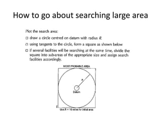
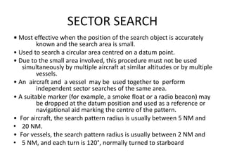
IAMSAR
VOLUME III
INTERNATIONAL AERONAUTICAL AND
MARITIME SEARCH &RESCUE MANUAL
Primary Purpose
• International Aeronautical and Maritime Search and
Rescue Manual is to assist States in meeting their own
search and rescue (SAR) needs and the obligations they
'accepted under the Convention on International Civil
Aviation, the International' Convention on Maritime
Search and Rescue, and the Safety of Life at Sea
(SOLAS).
• As per SOLAS it is the responsibility of all Masters are
obliged to proceed for assistance when ever a distress
message is received.
• As per SOLAS it is the responsibility of coastal states to
provide assistance for which a no of countries have
established national SAR organizations or have joined
one or more states to form a regional SAR organization.
Contents
• Purpose
• Responsibilities and Obligations to Assist
• National and Regional SAR System Organization
• SAR Co-ordination
• SAR Co-ordinators
• SAR Mission Co-ordinator
• On-Scene Co-ordinator
• Ship Reporting Systems
• Amver
• Aircraft Reporting System
• Underwater search and rescue
SAR Coordinator
• The SAR System has three general levels
• SAR Coordinator / SAR Mission Coordinator / On
Scene coordinator
• SAR Coordinators are top level managers their
duties include
a)Establishing , staffing, equipping and managing
the SAR system
b)Establishing RCC’s and rescue sub centre’s (RSC)
c)Provide or arrange SAR facilities
d)Coordinate SAR training
e)Developing SAR policies
SAR MISSION COORDINATORS
• Each SAR operation is carried out under the guidance of SMC. This
function exists only for the duration of a specific SAR incident and
is normally performed by the RCC chief or a designee. The SMC
may have assisting staff.
• The SMC guides a SAR operation until a rescue has been affected
or it becomes apparent that further efforts would be of no avail.
• Well trained in SAR processes and making SAR plans their duties
a)Gathering information about distress situation
b)Developing accurate SAR plans
c)Dispatch and coordinate the resources to carryout SAR Missions.
d)Evaluate emergency data, decide equipment required for mission
e)Remain informed about environmental conditions
f) Ascertain movements of vessels in the vicinity
g)Keeping listening watch for vessels movements
h) Make action plan and coordinate action with
other vessels
i)Evaluate reports and modify search plans as
required
j)Arrange supplies to survivors
k) Supply fuel to vessels used in operations
l)Determine when to suspend operations
m)Notify accident investigation authorities
n)Prepare final report
On Scene Coordinators
• When 2 or more SAR facilities are working
together on same mission one of them shall
be designated as on scene coordinator (OSC).
• He is designated by the Mission Coordinator
• He could be in charge for any assisting ship or
aircraft assisting in search
• His duties Coordinating search sending Sitrep
messages, carrying out actual search, making
reports, looking after survivors' etc
• ■ Responsibilities of OSC
• • The OSC should obtain a search action plan from the SMC via the RCC or
RSC as soon as possible. Normally, search planning is performed using
trained personnel, advanced search planning
• On-Scene Co-ordination
• techniques, and information about the incident or distressed craft not
normally available to the OSC. However, the OSC may still need to plan a
search under some circumstances. Search operations should commence as
soon as facilities are available at the scene. If a search plan has not been
provided by the SMC, the OSC should do the planning until an SMC
assumes the search planning function. Simplified techniques are
presented below.
• • Modify search plans based on changes in the on-scene situation, suchas:
• ❑arrival of additional assisting facilities
• ❑ receipt of additional information
• ❑changes in weather, visibility, lighting conditions, etc.
• On assuming the duty, the OSC should inform the SMC about progress at
regular intervals and whenever the situation has changed.
Ship Reporting system (SRS)
• Ship reporting systems have been established by several States.
• Ships at sea may be the only craft near the scene of a distressed
aircraft or vessel.
• A ship reporting system enables the SMC to quickly. Identify vessels
in the vicinity of a distress situation, along with their positions,
courses, and speeds be aware of other information about the
vessels which may be valuable (whether a doctor is aboard, etc.)
• know how to contact the vessels improve the likelihood of rapid aid
during emergencies
• reduce the number of calls for assistance to vessels unfavorably
located to respond
• reduce the response time to provide assistance.
• Masters of vessels are urged or mandated to send regular reports
to the authority operating a ship reporting system for SAR and
other safety-related services.
Amver
• Amver is one of many ship reporting systems. It is a world-
wide system operated exclusively to support SAR and
make information available to all RCCs.
• There is no charge for vessels to participate in, nor for
RCCs to use Amver.
• Many land-based providers of communications services
world-wide relay ship reports to Amver free of charge.
• Any merchant vessel of 1000 gross tons or more on any
voyage of greater than 24 hours is welcome to participate.
• Information voluntarily provided by vessels to Amver is
protected by the US Coast Guard as commercial
proprietary data and made available only to SAR
authorities or others specifically authorized by the ship
involved.
Search Function
• • The SMC typically provides the search action plan.
• • The OSC and facilities on-scene implement the search action plan
Situation
• ❑a brief description of the incident
• ❑position of the incident, and time that it occurred
• ❑number of persons on-board (POBs)
• ❑primary and secondary search objects
• ❑amount and types of survival equipment
• ❑weather forecast and period of forecast
• ❑SAR facilities on-scene
• Search area(s)
• ❑area designation, size, corner points, centre point, and circle radius
• ❑other essential data
• Execution
• ❑SAR facility identification, parent agency, search pattern, creep
direction, commence search points, and altitude
Rendering Assistance
• Co-ordination required
• ❑designates the SMC and OSC
• ❑desired track spacing and coverage factors
• ❑ airspace reservations (e.g., danger area)
• ❑aircraft safety instructions
• ❑ authorizations for non-SAR aircraft in the area
• Communications
• ❑ co-ordinating channels ❑on-scene channels
❑monitor channels
• ❑ method for OSC to be identified by SAR facilities ❑press channels, if
appropriate
• Reports
• ❑OSC reports of on-scene weather, progress, and other S1TREP information
• ❑parent agencies to provide summary at the end of daily
operations, (hours flown, area(s) searched, and coverage factor(s).
• ■ Developing Own Search Planning
• • Considerations in developing a search plan include:
• ❑estimating the most probable position of a distressed
craft or survivors, taking drift effect into consideration
• ❑determining the search area
• ❑ selecting SAR facilities and equipment to be used
• ❑selecting a search pattern
• ❑planning on-scene co-ordination.
• ■ Search Patterns
• Factors to consider & decide type of search pattern to use
❑available number and types of assisting craft
• ❑size of area to be searched
• ❑ type of distressed craft
Track Spacing
• To Carry out the various patterns given in IAMSAR it is
necessary to know the track spacing
• A table giving the Distance at which an object eg
Person in water, Liferaft / Lifeboat of various sizes will
be visible, depending upon visibility is given as Su (Wu)
for vessels and aircraft separately.
• The weather correction factor Fu is given in a separate
table .
• S (Track spacing)= WuXFu
• The area for search can be determined by the formula
A=SxVxT Vis speed of vessel & T is the time available
for search.
• The radius of search pattern is given by the formula
R= /A /2
Weather correction factor
How to go about searching large area
Expanding Square Search
• Most effective when the location of the search object is known within
relatively close limits.
• The commence search point is always the Datum Position.
• To be used by a single ship during a search.
• Often appropriate for vessels or small boats to use when searching for
persons in the water or other search objects with little or no leeway.
• Accurate navigation is required.
• The first leg is usually oriented directly into the wind to minimize
navigational errors.
• All course alterations are of 90O.
• Two first two legs will be of same length ‘d’. ‘d’ will depend upon the
visibility and the height of eye of the lookouts and the swell and sea
height.
– Legs 3 and 4 will be a length of 2d.
– Legs 5 and 6 will be a length of 3d.
– Legs 7 and 8 will be a length of 4d.
Expanding square search
SECTOR SEARCH
• Most effective when the position of the search object is accurately
known and the search area is small.
• Used to search a circular area centred on a datum point.
• Due to the small area involved, this procedure must not be used
simultaneously by multiple aircraft at similar altitudes or by multiple
vessels.
• An aircraft and a vessel may be used together to perform
independent sector searches of the same area.
• A suitable marker (for example, a smoke float or a radio beacon) may
be dropped at the datum position and used as a reference or
navigational aid marking the centre of the pattern.
• For aircraft, the search pattern radius is usually between 5 NM and
• 20 NM.
• For vessels, the search pattern radius is usually between 2 NM and
• 5 NM, and each turn is 120°, normally turned to starboard
SECTOR SEARCH
TRACK LINE SEARCH
• Normally used when an aircraft or vessel has disappeared
without a trace along a known route.
• Often used as initial search effort due to ease of planning
and implementation.
• Consists of a rapid and reasonably thorough search along
intended route of the distressed craft.
• Search may be along one side of the track line and
return. in the opposite direction on the other side (TSR).
• Search may be along the intended track and once on
each side, then search facility continues on its way and
does not return (TSN).
• Aircraft are ‘frequently used for TS due to their high
speed.
TRACK LINE SEARCH
PARALLEL SWEEP (TRACK) SEARCH
• Used to search a large area when the location of the search object is
uncertain.
• Most effective over water or flat terrain.
• Usually used when a large search area must be divided into sub-area
for assignment to individual search facilities on-scene at the same
time.
• The commence search point is in one corner of the sub-area, one-
half track space inside the rectangle from each of the two sides
forming the corner.
• Search legs are parallel to each other and to the long sides of the
sub-area.
• The main legs indicate the direction of drift.
• Multiple vessels may be used as shown opposite:
• Parallel sweep: for use by two ships.
• Parallel sweep: for use by three ships.
• Parallel sweep: for use by four ships.
• Parallel sweep: for use by five or more ships.
Parallel Sweep search 1 vessel /Aircraft
Parallel sweep search
PARALLEL SWEEP SEARCH
CONTOUR SEARCH
• Used around mountains and in valleys when sharp changes in
elevation make other patterns not practical.
• Search is started from highest peak and goes from top to bottom
with new search altitude for each circuit.
• Search altitude intervals may be 150 m to 300 m (500 to 1,000 ft).
• The aircraft may make a descending orbit away from the
mountain before resuming the contour search at the lower
altitude.
• The aircraft may spiral downwards around the mountain at a low
but approximately constant rate of descent when there is not
enough room to make a circuit opposite to the direction of
search.
• If the mountain cannot be circled, successive sweeps at the same
altitude intervals as listed above should be flown along its side.
• Valleys are searched in circles, moving the centre of the circuit
one track spacing after each completed circuit.
CO-ORDINATED VESSEL-AIRCRAFT Creeping line search
• To be used only if there is an OSC present to give direction to and provide
communications with the participating craft.
• The aircraft does most of the searching, while the ship steams along a course
at a speed as directed by the OSC so that the aircraft can use it as a
navigational checkpoint.
• The aircraft, as it passes over the ship, can easily make corrections to stay on
the track of its search pattern.
• Gives a higher probability of detection than can normally be attained by an
aircraft searching alone.
• Ship speed varies according to the speed of the aircraft and the size of the
pattern.
• The relationship among the speed of the surface facility, the aircraft’s speed,
the track spacing and the length of the search legs is defined by the following
equation: Vs = (5 x Va)/ (L + 5)
• Vs is the speed of the surface facility in knots; S is the track spacing in NM
• Va is the aircraft’s true air speed (TAS) in knots, and
• L is the length of the aircraft’s search leg in nautical miles.
Creeping Line search
ANDERSON TURN
Comparison of turns
• The Williamsons (WT)turn to be used in any condition
of visibility.
• With WT you will come back to same place from where
u gave a hard over helm
• Good for man overboard to return back to the place
where the man fell overboard.
• A Scharnov Turn ( ST) also known as delayed turn will
take you back in the ships wake.
• Anderson turn ( AT) is undertaken if the object is in
visible distance range & vessels manoeuvre- ability
normally good for vessels with twin engines.
• If used in place of WT after turn is complete you may
miss the target.
MAN OVER BOARD
• Hardover to side he has fallen. Consider stbd side
• Throw lifebuoy with smoke from bridge
• Ring man overboard alarm
• Mark position on GPS
• 60 degrees off course hard port
• Inform Engine room we shall be reducing speed
• Post lookout ford and aft to watch smoke signal.
• Get crew to lower rescue boat.
• When vessel 20 degrees off opposite course mid ship and steady
opposite course.
• Reduce speed. When speed of vessel below 5kts lower rescue boat
• Considered man close enough to lower boat.
• Pick up person from water.
MMD Questions
• Explain role of SAR Coordinator / Mission
coordinator / On scene coordinator
• What are the search patterns in IAMSAR ?
Explain any one pattern
• Explain Sector search when and where is it
used ? All other search patterns have come in
• Explain with diagrams Williamsons turn /
scharnov turn / Anderson turn?
• What turn will you utilized if vessel in fog ?

IAMSAR.pptx

  • 1.
    IAMSAR VOLUME III INTERNATIONAL AERONAUTICALAND MARITIME SEARCH &RESCUE MANUAL
  • 2.
    Primary Purpose • InternationalAeronautical and Maritime Search and Rescue Manual is to assist States in meeting their own search and rescue (SAR) needs and the obligations they 'accepted under the Convention on International Civil Aviation, the International' Convention on Maritime Search and Rescue, and the Safety of Life at Sea (SOLAS). • As per SOLAS it is the responsibility of all Masters are obliged to proceed for assistance when ever a distress message is received. • As per SOLAS it is the responsibility of coastal states to provide assistance for which a no of countries have established national SAR organizations or have joined one or more states to form a regional SAR organization.
  • 3.
    Contents • Purpose • Responsibilitiesand Obligations to Assist • National and Regional SAR System Organization • SAR Co-ordination • SAR Co-ordinators • SAR Mission Co-ordinator • On-Scene Co-ordinator • Ship Reporting Systems • Amver • Aircraft Reporting System • Underwater search and rescue
  • 4.
    SAR Coordinator • TheSAR System has three general levels • SAR Coordinator / SAR Mission Coordinator / On Scene coordinator • SAR Coordinators are top level managers their duties include a)Establishing , staffing, equipping and managing the SAR system b)Establishing RCC’s and rescue sub centre’s (RSC) c)Provide or arrange SAR facilities d)Coordinate SAR training e)Developing SAR policies
  • 5.
    SAR MISSION COORDINATORS •Each SAR operation is carried out under the guidance of SMC. This function exists only for the duration of a specific SAR incident and is normally performed by the RCC chief or a designee. The SMC may have assisting staff. • The SMC guides a SAR operation until a rescue has been affected or it becomes apparent that further efforts would be of no avail. • Well trained in SAR processes and making SAR plans their duties a)Gathering information about distress situation b)Developing accurate SAR plans c)Dispatch and coordinate the resources to carryout SAR Missions. d)Evaluate emergency data, decide equipment required for mission e)Remain informed about environmental conditions
  • 6.
    f) Ascertain movementsof vessels in the vicinity g)Keeping listening watch for vessels movements h) Make action plan and coordinate action with other vessels i)Evaluate reports and modify search plans as required j)Arrange supplies to survivors k) Supply fuel to vessels used in operations l)Determine when to suspend operations m)Notify accident investigation authorities n)Prepare final report
  • 7.
    On Scene Coordinators •When 2 or more SAR facilities are working together on same mission one of them shall be designated as on scene coordinator (OSC). • He is designated by the Mission Coordinator • He could be in charge for any assisting ship or aircraft assisting in search • His duties Coordinating search sending Sitrep messages, carrying out actual search, making reports, looking after survivors' etc
  • 8.
    • ■ Responsibilitiesof OSC • • The OSC should obtain a search action plan from the SMC via the RCC or RSC as soon as possible. Normally, search planning is performed using trained personnel, advanced search planning • On-Scene Co-ordination • techniques, and information about the incident or distressed craft not normally available to the OSC. However, the OSC may still need to plan a search under some circumstances. Search operations should commence as soon as facilities are available at the scene. If a search plan has not been provided by the SMC, the OSC should do the planning until an SMC assumes the search planning function. Simplified techniques are presented below. • • Modify search plans based on changes in the on-scene situation, suchas: • ❑arrival of additional assisting facilities • ❑ receipt of additional information • ❑changes in weather, visibility, lighting conditions, etc. • On assuming the duty, the OSC should inform the SMC about progress at regular intervals and whenever the situation has changed.
  • 9.
    Ship Reporting system(SRS) • Ship reporting systems have been established by several States. • Ships at sea may be the only craft near the scene of a distressed aircraft or vessel. • A ship reporting system enables the SMC to quickly. Identify vessels in the vicinity of a distress situation, along with their positions, courses, and speeds be aware of other information about the vessels which may be valuable (whether a doctor is aboard, etc.) • know how to contact the vessels improve the likelihood of rapid aid during emergencies • reduce the number of calls for assistance to vessels unfavorably located to respond • reduce the response time to provide assistance. • Masters of vessels are urged or mandated to send regular reports to the authority operating a ship reporting system for SAR and other safety-related services.
  • 10.
    Amver • Amver isone of many ship reporting systems. It is a world- wide system operated exclusively to support SAR and make information available to all RCCs. • There is no charge for vessels to participate in, nor for RCCs to use Amver. • Many land-based providers of communications services world-wide relay ship reports to Amver free of charge. • Any merchant vessel of 1000 gross tons or more on any voyage of greater than 24 hours is welcome to participate. • Information voluntarily provided by vessels to Amver is protected by the US Coast Guard as commercial proprietary data and made available only to SAR authorities or others specifically authorized by the ship involved.
  • 11.
    Search Function • •The SMC typically provides the search action plan. • • The OSC and facilities on-scene implement the search action plan Situation • ❑a brief description of the incident • ❑position of the incident, and time that it occurred • ❑number of persons on-board (POBs) • ❑primary and secondary search objects • ❑amount and types of survival equipment • ❑weather forecast and period of forecast • ❑SAR facilities on-scene • Search area(s) • ❑area designation, size, corner points, centre point, and circle radius • ❑other essential data • Execution • ❑SAR facility identification, parent agency, search pattern, creep direction, commence search points, and altitude
  • 12.
    Rendering Assistance • Co-ordinationrequired • ❑designates the SMC and OSC • ❑desired track spacing and coverage factors • ❑ airspace reservations (e.g., danger area) • ❑aircraft safety instructions • ❑ authorizations for non-SAR aircraft in the area • Communications • ❑ co-ordinating channels ❑on-scene channels ❑monitor channels • ❑ method for OSC to be identified by SAR facilities ❑press channels, if appropriate • Reports • ❑OSC reports of on-scene weather, progress, and other S1TREP information • ❑parent agencies to provide summary at the end of daily operations, (hours flown, area(s) searched, and coverage factor(s).
  • 13.
    • ■ DevelopingOwn Search Planning • • Considerations in developing a search plan include: • ❑estimating the most probable position of a distressed craft or survivors, taking drift effect into consideration • ❑determining the search area • ❑ selecting SAR facilities and equipment to be used • ❑selecting a search pattern • ❑planning on-scene co-ordination. • ■ Search Patterns • Factors to consider & decide type of search pattern to use ❑available number and types of assisting craft • ❑size of area to be searched • ❑ type of distressed craft
  • 14.
    Track Spacing • ToCarry out the various patterns given in IAMSAR it is necessary to know the track spacing • A table giving the Distance at which an object eg Person in water, Liferaft / Lifeboat of various sizes will be visible, depending upon visibility is given as Su (Wu) for vessels and aircraft separately. • The weather correction factor Fu is given in a separate table . • S (Track spacing)= WuXFu • The area for search can be determined by the formula A=SxVxT Vis speed of vessel & T is the time available for search. • The radius of search pattern is given by the formula R= /A /2
  • 17.
  • 18.
    How to goabout searching large area
  • 19.
    Expanding Square Search •Most effective when the location of the search object is known within relatively close limits. • The commence search point is always the Datum Position. • To be used by a single ship during a search. • Often appropriate for vessels or small boats to use when searching for persons in the water or other search objects with little or no leeway. • Accurate navigation is required. • The first leg is usually oriented directly into the wind to minimize navigational errors. • All course alterations are of 90O. • Two first two legs will be of same length ‘d’. ‘d’ will depend upon the visibility and the height of eye of the lookouts and the swell and sea height. – Legs 3 and 4 will be a length of 2d. – Legs 5 and 6 will be a length of 3d. – Legs 7 and 8 will be a length of 4d.
  • 20.
  • 21.
    SECTOR SEARCH • Mosteffective when the position of the search object is accurately known and the search area is small. • Used to search a circular area centred on a datum point. • Due to the small area involved, this procedure must not be used simultaneously by multiple aircraft at similar altitudes or by multiple vessels. • An aircraft and a vessel may be used together to perform independent sector searches of the same area. • A suitable marker (for example, a smoke float or a radio beacon) may be dropped at the datum position and used as a reference or navigational aid marking the centre of the pattern. • For aircraft, the search pattern radius is usually between 5 NM and • 20 NM. • For vessels, the search pattern radius is usually between 2 NM and • 5 NM, and each turn is 120°, normally turned to starboard
  • 22.
  • 23.
    TRACK LINE SEARCH •Normally used when an aircraft or vessel has disappeared without a trace along a known route. • Often used as initial search effort due to ease of planning and implementation. • Consists of a rapid and reasonably thorough search along intended route of the distressed craft. • Search may be along one side of the track line and return. in the opposite direction on the other side (TSR). • Search may be along the intended track and once on each side, then search facility continues on its way and does not return (TSN). • Aircraft are ‘frequently used for TS due to their high speed.
  • 24.
  • 25.
    PARALLEL SWEEP (TRACK)SEARCH • Used to search a large area when the location of the search object is uncertain. • Most effective over water or flat terrain. • Usually used when a large search area must be divided into sub-area for assignment to individual search facilities on-scene at the same time. • The commence search point is in one corner of the sub-area, one- half track space inside the rectangle from each of the two sides forming the corner. • Search legs are parallel to each other and to the long sides of the sub-area. • The main legs indicate the direction of drift. • Multiple vessels may be used as shown opposite: • Parallel sweep: for use by two ships. • Parallel sweep: for use by three ships. • Parallel sweep: for use by four ships. • Parallel sweep: for use by five or more ships.
  • 26.
    Parallel Sweep search1 vessel /Aircraft
  • 27.
  • 28.
  • 29.
    CONTOUR SEARCH • Usedaround mountains and in valleys when sharp changes in elevation make other patterns not practical. • Search is started from highest peak and goes from top to bottom with new search altitude for each circuit. • Search altitude intervals may be 150 m to 300 m (500 to 1,000 ft). • The aircraft may make a descending orbit away from the mountain before resuming the contour search at the lower altitude. • The aircraft may spiral downwards around the mountain at a low but approximately constant rate of descent when there is not enough room to make a circuit opposite to the direction of search. • If the mountain cannot be circled, successive sweeps at the same altitude intervals as listed above should be flown along its side. • Valleys are searched in circles, moving the centre of the circuit one track spacing after each completed circuit.
  • 31.
    CO-ORDINATED VESSEL-AIRCRAFT Creepingline search • To be used only if there is an OSC present to give direction to and provide communications with the participating craft. • The aircraft does most of the searching, while the ship steams along a course at a speed as directed by the OSC so that the aircraft can use it as a navigational checkpoint. • The aircraft, as it passes over the ship, can easily make corrections to stay on the track of its search pattern. • Gives a higher probability of detection than can normally be attained by an aircraft searching alone. • Ship speed varies according to the speed of the aircraft and the size of the pattern. • The relationship among the speed of the surface facility, the aircraft’s speed, the track spacing and the length of the search legs is defined by the following equation: Vs = (5 x Va)/ (L + 5) • Vs is the speed of the surface facility in knots; S is the track spacing in NM • Va is the aircraft’s true air speed (TAS) in knots, and • L is the length of the aircraft’s search leg in nautical miles.
  • 32.
  • 34.
  • 36.
    Comparison of turns •The Williamsons (WT)turn to be used in any condition of visibility. • With WT you will come back to same place from where u gave a hard over helm • Good for man overboard to return back to the place where the man fell overboard. • A Scharnov Turn ( ST) also known as delayed turn will take you back in the ships wake. • Anderson turn ( AT) is undertaken if the object is in visible distance range & vessels manoeuvre- ability normally good for vessels with twin engines. • If used in place of WT after turn is complete you may miss the target.
  • 37.
    MAN OVER BOARD •Hardover to side he has fallen. Consider stbd side • Throw lifebuoy with smoke from bridge • Ring man overboard alarm • Mark position on GPS • 60 degrees off course hard port • Inform Engine room we shall be reducing speed • Post lookout ford and aft to watch smoke signal. • Get crew to lower rescue boat. • When vessel 20 degrees off opposite course mid ship and steady opposite course. • Reduce speed. When speed of vessel below 5kts lower rescue boat • Considered man close enough to lower boat. • Pick up person from water.
  • 38.
    MMD Questions • Explainrole of SAR Coordinator / Mission coordinator / On scene coordinator • What are the search patterns in IAMSAR ? Explain any one pattern • Explain Sector search when and where is it used ? All other search patterns have come in • Explain with diagrams Williamsons turn / scharnov turn / Anderson turn? • What turn will you utilized if vessel in fog ?