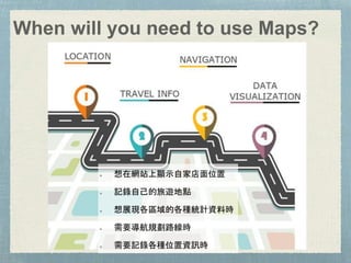
How to play with MAPS
林怡 Yi Lin@20180321
Google event/iOS Taipei
Majored in Geography.
Map lover.
Work @
An engineer tests whole
world maps every day.
Geodesign TPE Co-Organizer
MAPs 101 Introduction
LBS Application
Maps API & SDK
Useful tools
Data Visualization in Maps
When will you need to use Maps?
想在網站上顯示自家店面位置
記錄自己的旅遊地點
想展現各區域的各種統計資料時
需要導航規劃路線時
需要記錄各種位置資訊時
If you need to process some spatial data…
Feature Data
Point, Polyline, and Polygon.
River line, Building area, POIs (Point of Interest), Country
boundary. etc,
Raster Data
DTM/DEM, Satellite imagery
Any data put in the grids.
WGS84 (EPSG:4326)
World Geodetic System1984
Android內建海拔高度參照WGS84
Google map use this coordinate system.
TWD97/TWD67
TM2 zone 121
TAIWAN DATUM 97:1997 台灣大地基準
如果座標轉換搞不清
楚會出什麼問題?
https://buzzorange.com/techorange/2017/09/01/obike-help-gov/
Geography Markup Language, based on XML, to
describe geography spatial data.
GML contains a rich set of primitives which are used to
build application specific schemas or application
languages.
Feature, Geometry, Coordinate reference system,
Topology, Time, Dynamic feature, Coverage
(including geographic images), Unit of measure,
Directions, Observations, Map presentation styling
rules
KML - Made by Google.
KML is a language for the visualization of
geographic information tailored for Google
Earth.
KML is a 3D portrayal transport, not a data
exchange transport.
.shp - Shapefile, 圖形資料
.dbf - attribute data, can be opened by excel.
.kml - kind of XML
.kmz - a zip KML file
geojson
Location-based service
LBS Application
Google Maps
Apple Maps
maps.me
Navmii
Moovit
Waze
oBike/Ubike
Uber
公車來了沒
驅動城市
停車大聲公
Planning
Google Trips
Funliday
Booking and
Filghts
Booking.com
Agoda
Hotels.com
Skyscanner
街口支付
新光三越:LBS推播促銷
MOS Order 行動點餐
好房網快租
FB/Wechat/Line/Tinder/Instrgam
Check-in
Search near friends
Advertisement
TomTom Sports
STRAVA
Nike+
Ingress
Pokemon GO
Fog of World
Flightradar24
Taiwan First Indoor Navigation App
Indoor Navigation + Google Map Outdoor Navigation
Navigation
Place
Geocoding
Search
Streetviews
Location’s information
Google Maps API
https://developers.google.com/maps
https://www.youtube.com/watch?v=7Bbd5dbuPBc
https://developers.google.com/maps/documentation/javascript
/
iOS
https://developers.google.co
m/maps/documentation/ios-
sdk/
Android
https://developers.google.co
m/maps/documentation/and
roid-api/
Place
Map Style: Normal, Satellite, Terrain
Custom Marker
Street View
Polylines
Camera
Indoor
Search -
https://www.google.com/maps/search/?api=1&parameters
Direction-
https://www.google.com/maps/dir/?api=1&parameters
Display a map -
https://www.google.com/maps/@?api=1&map_action=map&parameters
Display a Street View -
https://www.google.com/maps/@?api=1&map_action=pano&parameter
s
More Information:
https://developers.google.com/maps/documentation/urls/guide
Maps SDK
iOS, Android, and JavaScript
https://developer.tomtom.com/tomtom-maps-apis-developers
OpenStreetMap is the free wiki world map.
https://www.openstreetmap.org/#map=16/25.0176/121.5379
https://www.mapbox.com
Offline mobile maps
Directions and traffic
Live data visualizations
building blocks
Maps
Search
Navigation
https://www.mapbox.com/ios-sdk/examples/
Data Visualization in Maps
台灣政治地緣資訊系統
http://test.geohealth.tw/tpgis/
http://elections.huffingtonpost.com/2013/massachusetts-senate-results
Global center of higher education: university
rankings
https://blog.csaladen.es/universities%20geo/
http://helenjacksonanalytic.co.uk/EW_prop_price.html
https://www.infino.me/mortality/usmap
What Kills US
Linked Geographic and Tree Maps
http://sunsp.net/demo/GeogTreeMaps/
Useful tools
https://ptx.transportdata.tw/PTX
http://ptx.transportdata.tw/MOTC
https://maps.nlsc.gov.tw/
https://www.tgos.tw/tgos/web/tgos_home.asp
x
WMS
Web Map Service
WMTS
Web Map Tile Service
WFS
Web Feature Service
Developed by OGC (Open Geospatial Consortium)
Web Map API
http://api.tgos.tw/TGOS_MAP_API/
Any
Questions?
Yi Lin 林怡
https://www.linkedin.com/in/y
i-lin-172776100/
riseswallow@gmail.com
Angela.Lin@tomtom.com

How to play with maps @ 20180321 Google sharing

Editor's Notes

  • #8 世界大地座標系 在Android系統內取得的海拔高度預設是參照WGS84而不是當地平均海平面,使得使用者在海邊定位時可能會發現自己的海拔位於海平面以下。 1997台灣大地基準(TWD97) 台灣、琉球嶼、綠島、蘭嶼及龜山島等地區 中央子午線:東經121度 座標原點N:赤道 座標原點E:西移 250000公尺 尺度比率 : 0.9999 澎湖、金門及馬祖等地區 中央子午線:東經119度 座標原點N:赤道 座標原點E:西移 250000公尺 尺度比率 : 0.9999
  • #12 + shp &dbf & KML pictures
  • #21 布設4350多個藍牙Beacon來協助定位、收發資訊,單一場域布設密度堪稱全亞洲第一,導航範圍包含北車、北捷、台北轉運站、桃園捷運、北門一帶的地上與地下空間。
  • #26 The real world as your playground: Build real-world games with Google Maps APIs
  • #38 互動式選舉地理資料庫
  • #40 https://blog.csaladen.es/universities%20geo/
  • #41 英國與威爾士房價圖表
  • #43 http://sunsp.net/demo/GeogTreeMaps/
  • #49 WMTS is a standard protocol for serving pre-rendered georeferenced map tiles over the Internet. 提供預先渲染(繪製)好的地圖圖磚介接 WMS is a standard protocol for serving georeferenced map images which a map server generates using data from a GIS database. 由GIS database 生成數據後產生地圖圖像介接