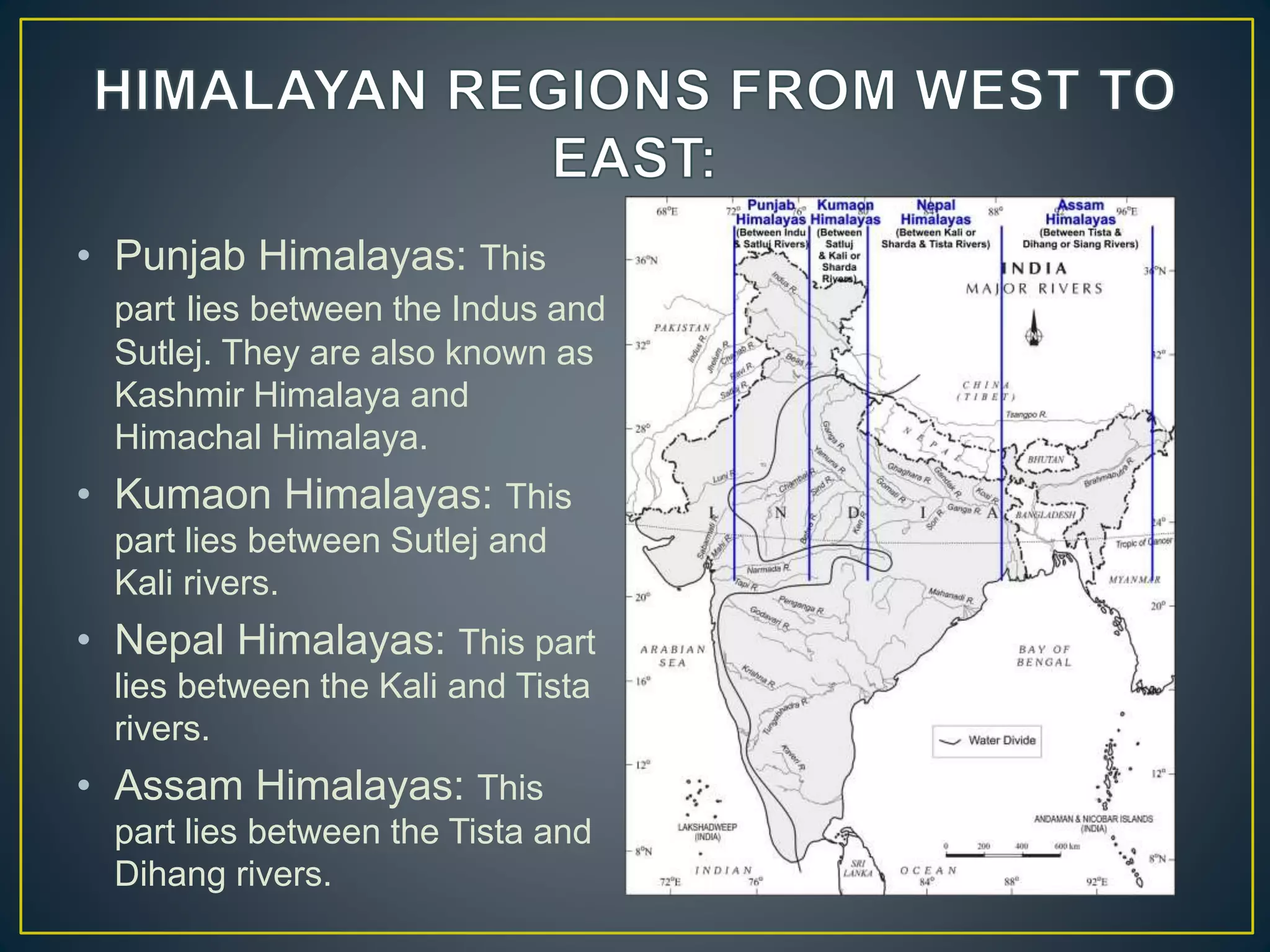
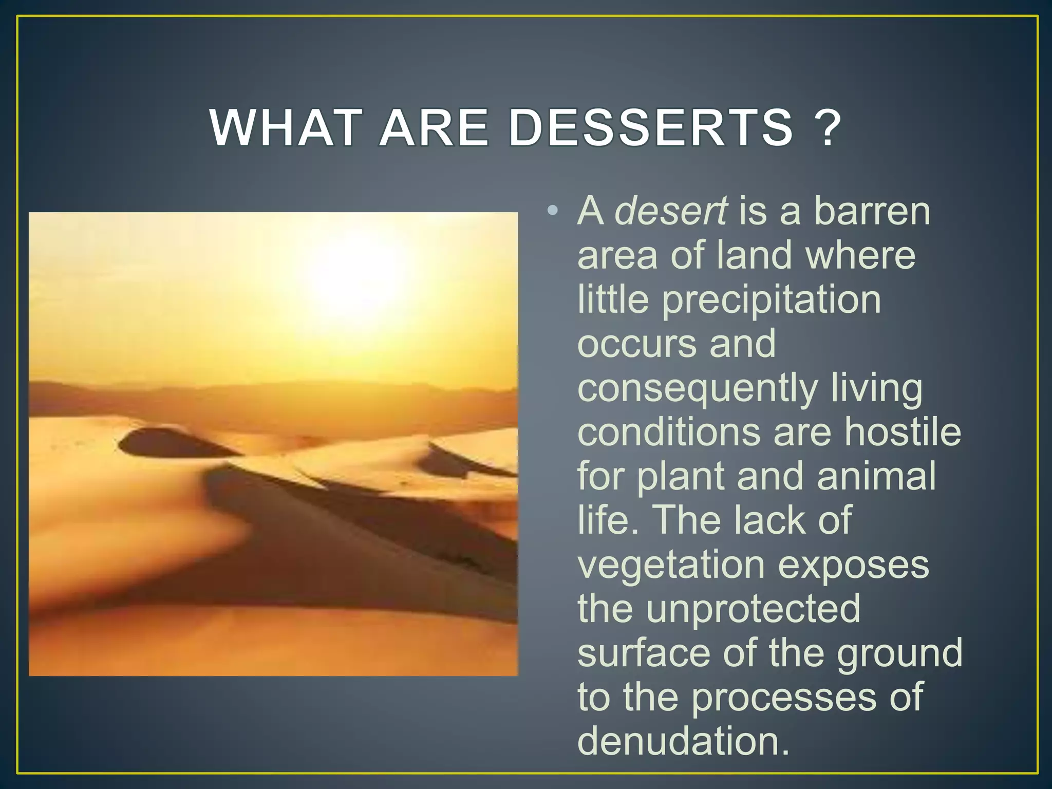
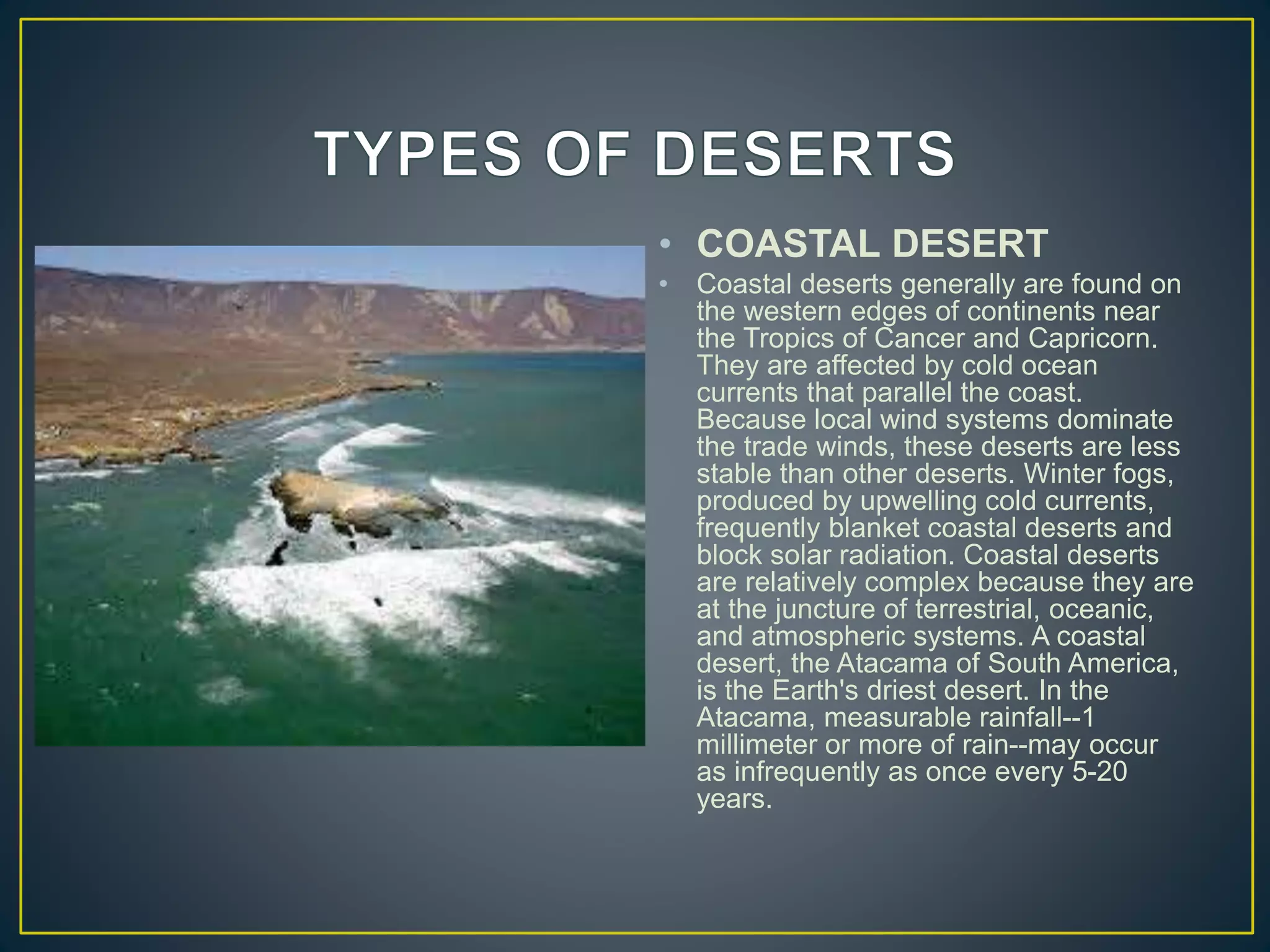
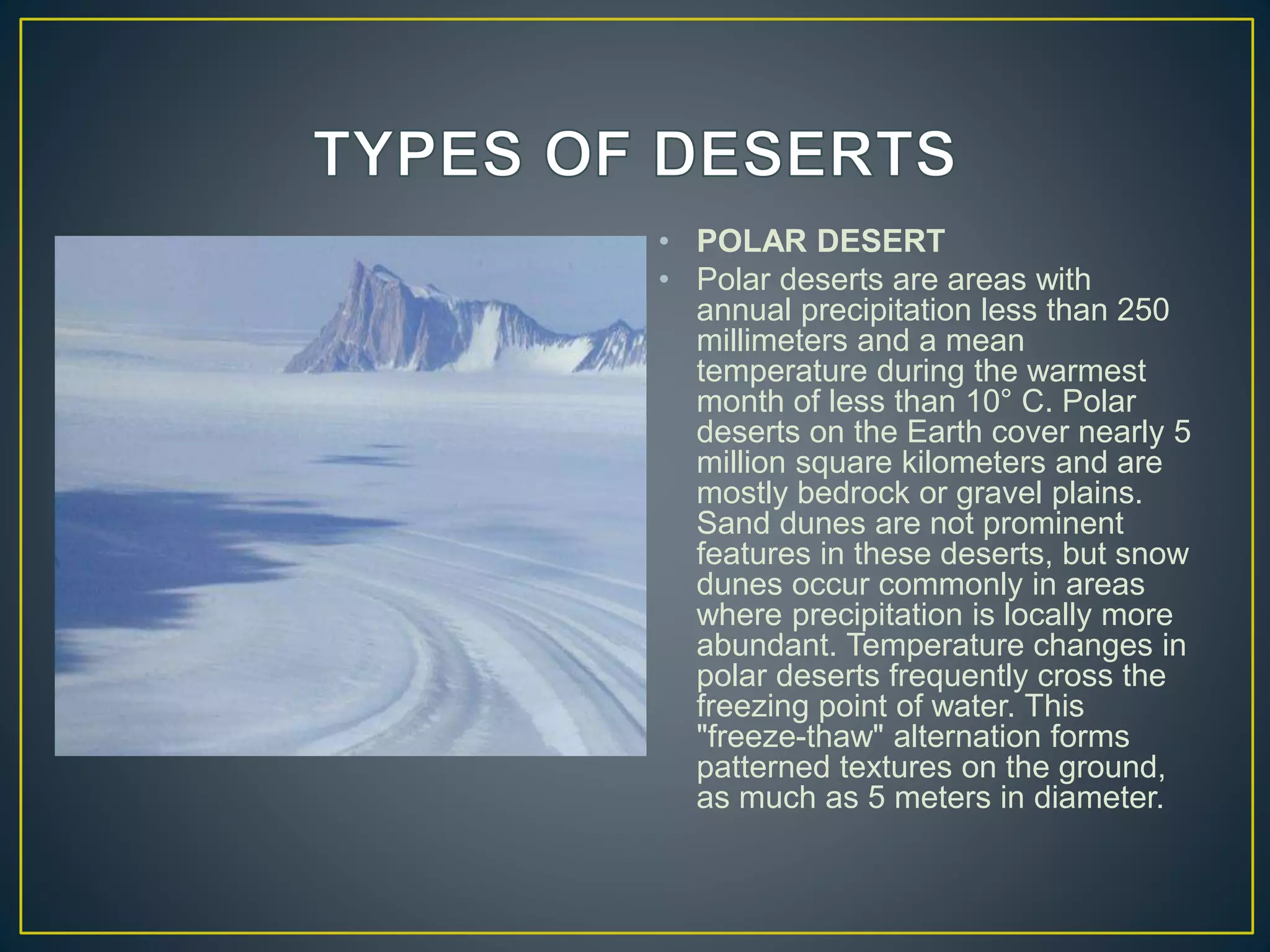
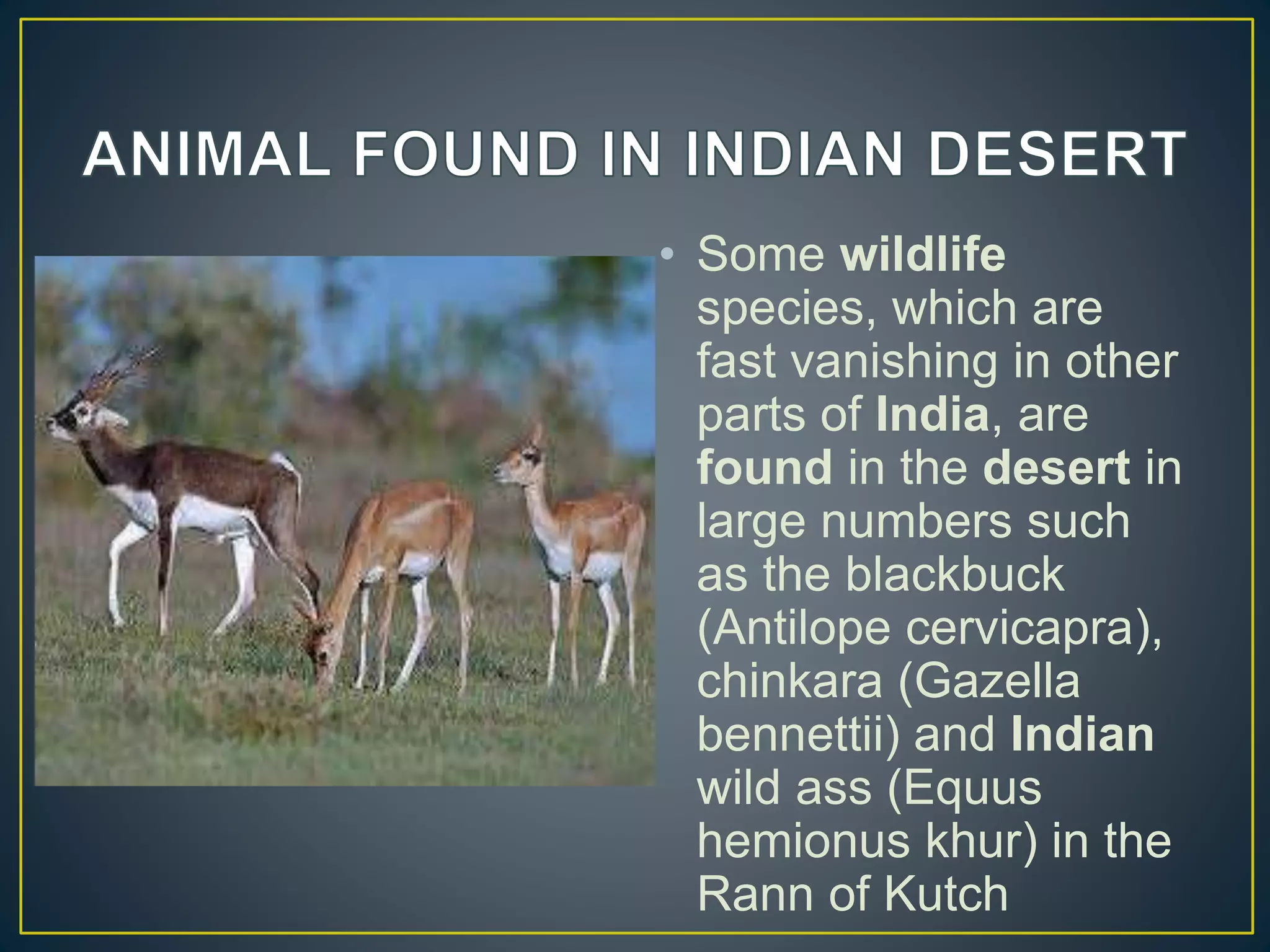
THE GREAT WALL OF A INDIA
THE BIRTH OF HIMALAYA
The birth of Himalayas dates back to million of years ago. There were series of
stages, which led to the formation of the Himalayas. The formation of the
Himalayas is the result of a collision of India with Asia along the convergent
boundary. There were powerful earth movement between the Indo-Australian
Plate and the Eurasian Plate that resulted in the creation of the Himalayan
range. The earth movements raised the deposits, which were laid down in the
shallow Tethys Sea, which is on the present location of the mountains. Today
also there is constant change and development in the mountains due to
earthquakes and tremors. The formation of the Andaman and Nicobar Islands
in the Bay of Bengal and the Arakan Yoma highlands in Myanmar is the result
of this collision. The collision of India with Asia was due the mechanics beneath
the earth's surface. There are various plates that collide, recede and slide from
each other at about 2 cm/year. This action beneath the earth's surface leads to
the rising of the Himalayas by about 5 mm per year. The heat generated
beneath the earth's surface results in this action of collision. It is the process of
convection that drives hot current upwards due to less density and cold current
downwards due to more density. This movement of Indian plate into the Asian
plate makes this region very active and prone to earthquakes. In the future also
the plate will move like this causing changes in the structure of the Himalayas.
The height and width of the mountain will change according to the action
beneath the earth's surface. In the north the mountains will be taller and smaller
in the south while the width remains the same.
1. HIMADRI
• This is the northernmost
range and is also known as
'Himadri'.
• This is the most continuous
range
• It contains the loftiest peaks.
• The folds of the Great
Himalayas are irregular in
nature
• Famous glaciers like the
Siachen Glacier, the Gangotri
and Yamunotri, etc
2. HIMACHAL
• This range lies towards the
south of the Great Himalayas
• The altitude of peaks in this
range varies from 3,700 to
4,500 meter
• Average width of this range is
50 km.
• This range is mainly composed
of highly compressed and
altered rocks.
• This region is also known as for
its hill stations (for e.g. Kullu,-
Manali, Kufri, Shimla,
Mussoorie, Nanital, etc.).
3. THE SHIWALIKS
• The outermost range of the
Himalayas is known as
Shiwaliks, also known as Manak
Parbat in ancient times.
• The altitude varies between 900
and 1100 meters in this range.
• The width varies between 10 to
50 km.
• These ranges are composed of
unconsolidated sediments
brought down by the rivers.
• The longitudinal valleys lying
between the Himachal and
Shiwaliks are called 'Dun'.
• Punjab Himalayas: This
part lies between the Indus and
Sutlej. They are also known as
Kashmir Himalaya and
Himachal Himalaya.
• Kumaon Himalayas: This
part lies between Sutlej and
Kali rivers.
• Nepal Himalayas: This part
lies between the Kali and Tista
rivers.
• Assam Himalayas: This
part lies between the Tista and
Dihang rivers.
• The Himalayas play a very significant role in influencing the climate of India. By virtue
of their high altitude, length and direction, they effectively intercept the summer
monsoons coming from the Bay of Bengal and Arabian Sea and cause precipitation in
the form of rain or snow.
• Besides, they prevent the cold continental air masses of central Asia from entering
into India. Had there been no Himalayas, the whole of India would have been a desert
in the absence of precipitation and its winters would have been very severe under the
influence of cold airmasses coming from Central Asia. According to the latest
meteorological studies, the Himalayas are responsible for splitting the jet stream into
two branches and these in turn play an extremely important role in bring monsoons in
India.
• The Himalayas have been protecting India from outside invaders
since the early times thus serving as a defence barrier. But the
Chinese aggression on India in October, 1962 has reduced the
defence significance of the Himalayas to a considerable extent. In
spite of advancement in modem warfare technology, the defence
significance of the Himalayas cannot be ignored altogether.
• Almost all the great rivers of India have their sources in the
Himalayan ranges. Abundant rainfall and vast snow-fields as well as
large glaciers are the feeding grounds of the mighty rivers of India.
Snow melt in summer provides water to these rivers even during dry
season and these are perennial rivers. The Himalayan Rivers, along
with hundreds of their tributaries, form the very basis of life in the
whole of north India.
• FLORA
• The transition zones from sub-tropical
warmth to arctic colds are telescoped
into a mere 250 kilometers (156 miles)
between the Punjab plains and the
Tibetan plateau
• Towards the plains, the Shivalk are
fringed with broad-leaved Sal and silk
cotton, which give way to sheesham,
kail and the long leaved cheer pine on
the slopes of the foothills. A temperate
zone of the mixed forests follows on the
lower reaches of the Dhauladhars and
Pir Panjal ranges,
• FAUNA
• the Himalayan choughs, rose finches
and accentors. Overhead, gliding in the
thermals, one is likely to spot the griffon
vulture, perhaps the Lammergeyer with
its beard and nine-foot wingspan, and if
one is lucky, the golden eagle. The
sight of a skein of wild geese on their
migratory flight, flights the wind at
6,000 meters (20,000 feet)
• In June 2013, a multi-day cloudburst centered on the
North Indian state of Uttarakhand caused devastating
floods and landslides becoming the country's worst
natural disaster since the 2004 tsunami.
• REASON BEHIND THE DISTRUCTION
• The reason the floods were on such a larger scale than
the regular floods the state usually received was because
of the debris of the building of dams upstream. The
debris blocked up the rivers, causing major overflow.
• The India Meteorological Department (IMD) linked heavy
to very heavy rain-fall on the higher Uttarakhand,
Himachal and Nepal Himalaya to the convergence of the
Southwest Monsoon trough and (5:00 p.m.) and 16 June
A DEAD AREA OF A NATIONAL
• A desert is a barren
area of land where
little precipitation
occurs and
consequently living
conditions are hostile
for plant and animal
life. The lack of
vegetation exposes
the unprotected
surface of the ground
to the processes of
denudation.
LARGEST DESERT
• The largest is the Sahara
Desert , a subtropical desert in
northern Africa. It covers a
surface area of about 3.5
million square miles.
SMALLEST DESERT
• The Carcross Desert, tucked
away in the Yukon Territories,
measures approximately 1
square mile. it's often referred
to as the smallest desert in the
world, but technically, it's just a
series of sand dunes since the
area is too humid to be
considered an actual desert.
• TRADE WIND
DESERTS
• The trade winds in two belts on
the equatorial sides of the
Horse Latitudes heat up as
they move toward the Equator.
These dry winds dissipate
cloud cover, allowing more
sunlight to heat the land. Most
of the major deserts of the
world lie in areas crossed by
the trade winds. The world's
largest desert, the Sahara of
North Africa, which has
experienced temperatures as
high as 57° C, is a trade wind
desert.
• MIDLATITUDE
DESERT
• Midlatitude deserts
occur between 30° and
50° N. and S., poleward
of the subtropical
highpressure zones.
These deserts are in
interior drainage basins
far from oceans and
have a wide range of
annual temperatures.
The Sonoran Desert of
southwestern North
America is a typical
midlatitude desert.
• RAINSHADOW
DESERT
• Rain shadow deserts are
formed because tall mountain
ranges prevent moisture-rich
clouds from reaching areas on
the lee, or protected side, of the
range. As air rises over the
mountain, water is precipitated
and the air loses its moisture
content. A desert is formed in
the leeside "shadow" of the
range.
• COASTAL DESERT
• Coastal deserts generally are found on
the western edges of continents near
the Tropics of Cancer and Capricorn.
They are affected by cold ocean
currents that parallel the coast.
Because local wind systems dominate
the trade winds, these deserts are less
stable than other deserts. Winter fogs,
produced by upwelling cold currents,
frequently blanket coastal deserts and
block solar radiation. Coastal deserts
are relatively complex because they are
at the juncture of terrestrial, oceanic,
and atmospheric systems. A coastal
desert, the Atacama of South America,
is the Earth's driest desert. In the
Atacama, measurable rainfall--1
millimeter or more of rain--may occur
as infrequently as once every 5-20
years.
• MONSON DESERT
• "Monsoon," derived from an Arabic
word for "season," refers to a wind
system with pronounced seasonal
reversal. Monsoons develop in
response to temperature variations
between continents and oceans.
The southeast trade winds of the
Indian Ocean, for example, provide
heavy summer rains in India as
they move onshore. As the
monsoon crosses India, it loses
moisture on the eastern slopes of
the Aravalli Range. The Rajasthan
Desert of India and the Thar Desert
of Pakistan are parts of a monsoon
desert region west of the ranqe.
• POLAR DESERT
• Polar deserts are areas with
annual precipitation less than 250
millimeters and a mean
temperature during the warmest
month of less than 10° C. Polar
deserts on the Earth cover nearly 5
million square kilometers and are
mostly bedrock or gravel plains.
Sand dunes are not prominent
features in these deserts, but snow
dunes occur commonly in areas
where precipitation is locally more
abundant. Temperature changes in
polar deserts frequently cross the
freezing point of water. This
"freeze-thaw" alternation forms
patterned textures on the ground,
as much as 5 meters in diameter.
• Some wildlife
species, which are
fast vanishing in other
parts of India, are
found in the desert in
large numbers such
as the blackbuck
(Antilope cervicapra),
chinkara (Gazella
bennettii) and Indian
wild ass (Equus
hemionus khur) in the
Rann of Kutch
• Among the mammal
species still found in the
Sahara are the gerbil,
jerboa, Cape hare, and
desert hedgehog;
Barbary sheep and
scimitar-horned oryx;
dorcas gazelle, dama
deer, and Nubian wild
ass; anubis baboon;
spotted hyena, common
jackal, and sand fox;
and Libyan striped
weasel and slender
mongoose
• The animals include
the reindeer, polar
bear, Arctic fox,
narwhal, walrus,
seal, ox, moose,
orca, and snowy owl.
The Alaskan
malamute is a
powerful sled dog
from Alaska. This
small, white fox lives
farther north than any
other land animal
SUBMITTED BY :- DEVANSH CHHAPARAWAL GRADE :- IX “A”

Himalaya,s copy

  • 1.
    THE GREAT WALLOF A INDIA
  • 2.
    THE BIRTH OFHIMALAYA The birth of Himalayas dates back to million of years ago. There were series of stages, which led to the formation of the Himalayas. The formation of the Himalayas is the result of a collision of India with Asia along the convergent boundary. There were powerful earth movement between the Indo-Australian Plate and the Eurasian Plate that resulted in the creation of the Himalayan range. The earth movements raised the deposits, which were laid down in the shallow Tethys Sea, which is on the present location of the mountains. Today also there is constant change and development in the mountains due to earthquakes and tremors. The formation of the Andaman and Nicobar Islands in the Bay of Bengal and the Arakan Yoma highlands in Myanmar is the result of this collision. The collision of India with Asia was due the mechanics beneath the earth's surface. There are various plates that collide, recede and slide from each other at about 2 cm/year. This action beneath the earth's surface leads to the rising of the Himalayas by about 5 mm per year. The heat generated beneath the earth's surface results in this action of collision. It is the process of convection that drives hot current upwards due to less density and cold current downwards due to more density. This movement of Indian plate into the Asian plate makes this region very active and prone to earthquakes. In the future also the plate will move like this causing changes in the structure of the Himalayas. The height and width of the mountain will change according to the action beneath the earth's surface. In the north the mountains will be taller and smaller in the south while the width remains the same.
  • 3.
    1. HIMADRI • Thisis the northernmost range and is also known as 'Himadri'. • This is the most continuous range • It contains the loftiest peaks. • The folds of the Great Himalayas are irregular in nature • Famous glaciers like the Siachen Glacier, the Gangotri and Yamunotri, etc
  • 4.
    2. HIMACHAL • Thisrange lies towards the south of the Great Himalayas • The altitude of peaks in this range varies from 3,700 to 4,500 meter • Average width of this range is 50 km. • This range is mainly composed of highly compressed and altered rocks. • This region is also known as for its hill stations (for e.g. Kullu,- Manali, Kufri, Shimla, Mussoorie, Nanital, etc.).
  • 5.
    3. THE SHIWALIKS •The outermost range of the Himalayas is known as Shiwaliks, also known as Manak Parbat in ancient times. • The altitude varies between 900 and 1100 meters in this range. • The width varies between 10 to 50 km. • These ranges are composed of unconsolidated sediments brought down by the rivers. • The longitudinal valleys lying between the Himachal and Shiwaliks are called 'Dun'.
  • 6.
    • Punjab Himalayas:This part lies between the Indus and Sutlej. They are also known as Kashmir Himalaya and Himachal Himalaya. • Kumaon Himalayas: This part lies between Sutlej and Kali rivers. • Nepal Himalayas: This part lies between the Kali and Tista rivers. • Assam Himalayas: This part lies between the Tista and Dihang rivers.
  • 9.
    • The Himalayasplay a very significant role in influencing the climate of India. By virtue of their high altitude, length and direction, they effectively intercept the summer monsoons coming from the Bay of Bengal and Arabian Sea and cause precipitation in the form of rain or snow. • Besides, they prevent the cold continental air masses of central Asia from entering into India. Had there been no Himalayas, the whole of India would have been a desert in the absence of precipitation and its winters would have been very severe under the influence of cold airmasses coming from Central Asia. According to the latest meteorological studies, the Himalayas are responsible for splitting the jet stream into two branches and these in turn play an extremely important role in bring monsoons in India.
  • 10.
    • The Himalayashave been protecting India from outside invaders since the early times thus serving as a defence barrier. But the Chinese aggression on India in October, 1962 has reduced the defence significance of the Himalayas to a considerable extent. In spite of advancement in modem warfare technology, the defence significance of the Himalayas cannot be ignored altogether.
  • 11.
    • Almost allthe great rivers of India have their sources in the Himalayan ranges. Abundant rainfall and vast snow-fields as well as large glaciers are the feeding grounds of the mighty rivers of India. Snow melt in summer provides water to these rivers even during dry season and these are perennial rivers. The Himalayan Rivers, along with hundreds of their tributaries, form the very basis of life in the whole of north India.
  • 12.
    • FLORA • Thetransition zones from sub-tropical warmth to arctic colds are telescoped into a mere 250 kilometers (156 miles) between the Punjab plains and the Tibetan plateau • Towards the plains, the Shivalk are fringed with broad-leaved Sal and silk cotton, which give way to sheesham, kail and the long leaved cheer pine on the slopes of the foothills. A temperate zone of the mixed forests follows on the lower reaches of the Dhauladhars and Pir Panjal ranges, • FAUNA • the Himalayan choughs, rose finches and accentors. Overhead, gliding in the thermals, one is likely to spot the griffon vulture, perhaps the Lammergeyer with its beard and nine-foot wingspan, and if one is lucky, the golden eagle. The sight of a skein of wild geese on their migratory flight, flights the wind at 6,000 meters (20,000 feet)
  • 14.
    • In June2013, a multi-day cloudburst centered on the North Indian state of Uttarakhand caused devastating floods and landslides becoming the country's worst natural disaster since the 2004 tsunami. • REASON BEHIND THE DISTRUCTION • The reason the floods were on such a larger scale than the regular floods the state usually received was because of the debris of the building of dams upstream. The debris blocked up the rivers, causing major overflow. • The India Meteorological Department (IMD) linked heavy to very heavy rain-fall on the higher Uttarakhand, Himachal and Nepal Himalaya to the convergence of the Southwest Monsoon trough and (5:00 p.m.) and 16 June
  • 15.
    A DEAD AREAOF A NATIONAL
  • 16.
    • A desertis a barren area of land where little precipitation occurs and consequently living conditions are hostile for plant and animal life. The lack of vegetation exposes the unprotected surface of the ground to the processes of denudation.
  • 17.
    LARGEST DESERT • Thelargest is the Sahara Desert , a subtropical desert in northern Africa. It covers a surface area of about 3.5 million square miles. SMALLEST DESERT • The Carcross Desert, tucked away in the Yukon Territories, measures approximately 1 square mile. it's often referred to as the smallest desert in the world, but technically, it's just a series of sand dunes since the area is too humid to be considered an actual desert.
  • 18.
    • TRADE WIND DESERTS •The trade winds in two belts on the equatorial sides of the Horse Latitudes heat up as they move toward the Equator. These dry winds dissipate cloud cover, allowing more sunlight to heat the land. Most of the major deserts of the world lie in areas crossed by the trade winds. The world's largest desert, the Sahara of North Africa, which has experienced temperatures as high as 57° C, is a trade wind desert.
  • 19.
    • MIDLATITUDE DESERT • Midlatitudedeserts occur between 30° and 50° N. and S., poleward of the subtropical highpressure zones. These deserts are in interior drainage basins far from oceans and have a wide range of annual temperatures. The Sonoran Desert of southwestern North America is a typical midlatitude desert.
  • 20.
    • RAINSHADOW DESERT • Rainshadow deserts are formed because tall mountain ranges prevent moisture-rich clouds from reaching areas on the lee, or protected side, of the range. As air rises over the mountain, water is precipitated and the air loses its moisture content. A desert is formed in the leeside "shadow" of the range.
  • 21.
    • COASTAL DESERT •Coastal deserts generally are found on the western edges of continents near the Tropics of Cancer and Capricorn. They are affected by cold ocean currents that parallel the coast. Because local wind systems dominate the trade winds, these deserts are less stable than other deserts. Winter fogs, produced by upwelling cold currents, frequently blanket coastal deserts and block solar radiation. Coastal deserts are relatively complex because they are at the juncture of terrestrial, oceanic, and atmospheric systems. A coastal desert, the Atacama of South America, is the Earth's driest desert. In the Atacama, measurable rainfall--1 millimeter or more of rain--may occur as infrequently as once every 5-20 years.
  • 22.
    • MONSON DESERT •"Monsoon," derived from an Arabic word for "season," refers to a wind system with pronounced seasonal reversal. Monsoons develop in response to temperature variations between continents and oceans. The southeast trade winds of the Indian Ocean, for example, provide heavy summer rains in India as they move onshore. As the monsoon crosses India, it loses moisture on the eastern slopes of the Aravalli Range. The Rajasthan Desert of India and the Thar Desert of Pakistan are parts of a monsoon desert region west of the ranqe.
  • 23.
    • POLAR DESERT •Polar deserts are areas with annual precipitation less than 250 millimeters and a mean temperature during the warmest month of less than 10° C. Polar deserts on the Earth cover nearly 5 million square kilometers and are mostly bedrock or gravel plains. Sand dunes are not prominent features in these deserts, but snow dunes occur commonly in areas where precipitation is locally more abundant. Temperature changes in polar deserts frequently cross the freezing point of water. This "freeze-thaw" alternation forms patterned textures on the ground, as much as 5 meters in diameter.
  • 24.
    • Some wildlife species,which are fast vanishing in other parts of India, are found in the desert in large numbers such as the blackbuck (Antilope cervicapra), chinkara (Gazella bennettii) and Indian wild ass (Equus hemionus khur) in the Rann of Kutch
  • 25.
    • Among themammal species still found in the Sahara are the gerbil, jerboa, Cape hare, and desert hedgehog; Barbary sheep and scimitar-horned oryx; dorcas gazelle, dama deer, and Nubian wild ass; anubis baboon; spotted hyena, common jackal, and sand fox; and Libyan striped weasel and slender mongoose
  • 26.
    • The animalsinclude the reindeer, polar bear, Arctic fox, narwhal, walrus, seal, ox, moose, orca, and snowy owl. The Alaskan malamute is a powerful sled dog from Alaska. This small, white fox lives farther north than any other land animal
  • 27.
    SUBMITTED BY :-DEVANSH CHHAPARAWAL GRADE :- IX “A”