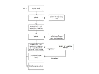
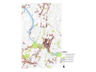
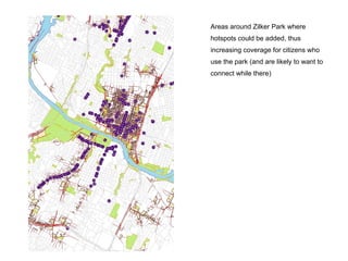
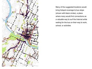
Creating a
Wireless City
Hillary Funk
Wi-Fi in Austin
● In 2006, City of Austin began wireless mesh
project, which no longer exists
● Austin currently has over 250 public Wi-Fi
hotspots, mostly located in restaurants, bars,
libraries, hotels, and other businesses (often
for a fee or paying customers)
● City of Pflugerville investing at least $40,000
to provide Wi-Fi in five city parks
Wi-Fi in general
● 56 cities are "Municipal Wireless Networks",
which is defined as turning an entire city into
a Wireless access zone
● The range of Wi-Fi hotspots is typically 300
feet
● Are public hotspots still needed with today's
devices? (have you ever browsed on your
phone for long periods of time or used your
phone as a hotspot?)
Problem statement
If the City of Austin or another entity
determined they wanted to add hotspots in
Central Austin, where should they be placed to
ensure public access to wireless Internet is
more universal?
Data
● Census Bureau GIS Data
○ Edges Layer (line shape file, shows streets in CoA)
● City of Austin GIS Data
○ City of Austin Parks (polygon shape file)
○ Lakes (polygon shape file)
○ Zoning (polygon shape file, represents zoning classifications including
residential, commercial, industrial, and special purposes)
● Current Wi-Fi Hotspots
○ AT&T wi-fi hotspot locations; City of Austin GIS Data Sets; Free wi-fi
hotspots in austin, tx; Hotspot directory; The wi-fi free spot directory;
TWC wi-fi coverage map
● Capital Metro Data
○ Capital Metro Transit Stops (point shape file)
Methodology
Note: Looked up Zoning District definitions on City of Austin's website to determine what
areas were considered commercial.
Methodology (cont.)
Wi-Fi Hotspots are generally along main
streets, where they are most likely either
inside of restaurants or bars, or close by
enough that patrons can use them. The
future ideal locations of Wi-Fi Hotspots
show up by commercial areas where no
hotspots are currently located, or on
side streets close to commercial areas
where hotspot access could provide
additional value.
Hotspot density in downtown Austin and
just slightly North of Downtown around
Burnet Road area where quite a few
restaurants, bars, and coffee shops are
located, but further North by Anderson
Lane where development is growing
with restaurants, bars, and coffee
shops, there are many open areas
where no coverage is located and could
be ideal spots to add new hotspots.
Areas around Zilker Park where
hotspots could be added, thus
increasing coverage for citizens who
use the park (and are likely to want to
connect while there)
Many of the suggested locations would
bring hotspot coverage to bus stops
(shown with black circles), a place
where many would find connections as
a valuable way to surf the Internet while
waiting for the bus on their way to work,
school, or activities.
Conclusion
● This is only a starting point
● 300 feet range is only an average...list is not
necessarily all inclusive or forward looking
● There is a significant difference between free
and paid public hotspots so to truly become
a wireless city it would mean adding free Wi-
Fi.
References
AT&T wi-fi hotspot locations. (n.d.). Retrieved from www.att.com
Capital Metro Geospatial Data. (n.d.). Retrieved from www.capmetro.org/datastats.aspx
City of Austin GIS Data Sets. (n.d.). Retrieved from ftp://ftp.ci.austin.tx.us/GIS-Data/Regional/coa_gis.html
Free wi-fi hotspots in austin, tx. (n.d.). Retrieved from www.openwifispots.com
Fuentes-Bautista, M., & Inagaki, N. (2006). Reconfiguring public internet access in austin, tx: Wi-fi's promise and broadband
divides. Government Information Quarterly, 23(3-4), 404-434.
Hotspot directory. (n.d.). Retrieved from www.lessnetworks.com
Pantazes, L. (n.d.). Pflugerville to offer free wi-fi at 5 city parks. Retrieved from www.keyetv.com
Seldon, J. (2006, 04 28). Downtown wi-fi network goes live. Austin Business Journal. Retrieved from www.bizjournals.com/austin
Municipal wireless network. (n.d.). Retrieved from www.wikipedia.org
The wi-fi free spot directory. (n.d.). Retrieved from www.wififreespot.com
TWC wi-fi coverage map. (n.d.). Retrieved from www.timewarnercable.com
United States Census Bureau Geography. (n.d.) Retrieved from http://www.census.gov/geo/maps-data/data/tiger-line.html
Wi-fi. (n.d.). Retrieved from www.wikipedia.org
Zoning districts. (n.d.). Retrieved from http://austintexas.gov/page/zoning-districts

Creating a Wireless City

  • 1.
  • 2.
    Wi-Fi in Austin ●In 2006, City of Austin began wireless mesh project, which no longer exists ● Austin currently has over 250 public Wi-Fi hotspots, mostly located in restaurants, bars, libraries, hotels, and other businesses (often for a fee or paying customers) ● City of Pflugerville investing at least $40,000 to provide Wi-Fi in five city parks
  • 3.
    Wi-Fi in general ●56 cities are "Municipal Wireless Networks", which is defined as turning an entire city into a Wireless access zone ● The range of Wi-Fi hotspots is typically 300 feet ● Are public hotspots still needed with today's devices? (have you ever browsed on your phone for long periods of time or used your phone as a hotspot?)
  • 4.
    Problem statement If theCity of Austin or another entity determined they wanted to add hotspots in Central Austin, where should they be placed to ensure public access to wireless Internet is more universal?
  • 5.
    Data ● Census BureauGIS Data ○ Edges Layer (line shape file, shows streets in CoA) ● City of Austin GIS Data ○ City of Austin Parks (polygon shape file) ○ Lakes (polygon shape file) ○ Zoning (polygon shape file, represents zoning classifications including residential, commercial, industrial, and special purposes) ● Current Wi-Fi Hotspots ○ AT&T wi-fi hotspot locations; City of Austin GIS Data Sets; Free wi-fi hotspots in austin, tx; Hotspot directory; The wi-fi free spot directory; TWC wi-fi coverage map ● Capital Metro Data ○ Capital Metro Transit Stops (point shape file)
  • 6.
    Methodology Note: Looked upZoning District definitions on City of Austin's website to determine what areas were considered commercial.
  • 7.
  • 10.
    Wi-Fi Hotspots aregenerally along main streets, where they are most likely either inside of restaurants or bars, or close by enough that patrons can use them. The future ideal locations of Wi-Fi Hotspots show up by commercial areas where no hotspots are currently located, or on side streets close to commercial areas where hotspot access could provide additional value.
  • 11.
    Hotspot density indowntown Austin and just slightly North of Downtown around Burnet Road area where quite a few restaurants, bars, and coffee shops are located, but further North by Anderson Lane where development is growing with restaurants, bars, and coffee shops, there are many open areas where no coverage is located and could be ideal spots to add new hotspots.
  • 12.
    Areas around ZilkerPark where hotspots could be added, thus increasing coverage for citizens who use the park (and are likely to want to connect while there)
  • 13.
    Many of thesuggested locations would bring hotspot coverage to bus stops (shown with black circles), a place where many would find connections as a valuable way to surf the Internet while waiting for the bus on their way to work, school, or activities.
  • 14.
    Conclusion ● This isonly a starting point ● 300 feet range is only an average...list is not necessarily all inclusive or forward looking ● There is a significant difference between free and paid public hotspots so to truly become a wireless city it would mean adding free Wi- Fi.
  • 15.
    References AT&T wi-fi hotspotlocations. (n.d.). Retrieved from www.att.com Capital Metro Geospatial Data. (n.d.). Retrieved from www.capmetro.org/datastats.aspx City of Austin GIS Data Sets. (n.d.). Retrieved from ftp://ftp.ci.austin.tx.us/GIS-Data/Regional/coa_gis.html Free wi-fi hotspots in austin, tx. (n.d.). Retrieved from www.openwifispots.com Fuentes-Bautista, M., & Inagaki, N. (2006). Reconfiguring public internet access in austin, tx: Wi-fi's promise and broadband divides. Government Information Quarterly, 23(3-4), 404-434. Hotspot directory. (n.d.). Retrieved from www.lessnetworks.com Pantazes, L. (n.d.). Pflugerville to offer free wi-fi at 5 city parks. Retrieved from www.keyetv.com Seldon, J. (2006, 04 28). Downtown wi-fi network goes live. Austin Business Journal. Retrieved from www.bizjournals.com/austin Municipal wireless network. (n.d.). Retrieved from www.wikipedia.org The wi-fi free spot directory. (n.d.). Retrieved from www.wififreespot.com TWC wi-fi coverage map. (n.d.). Retrieved from www.timewarnercable.com United States Census Bureau Geography. (n.d.) Retrieved from http://www.census.gov/geo/maps-data/data/tiger-line.html Wi-fi. (n.d.). Retrieved from www.wikipedia.org Zoning districts. (n.d.). Retrieved from http://austintexas.gov/page/zoning-districts