This document summarizes OSM, a free and open source mobile map viewer application for phones. It can display maps and points of interest from OpenStreetMap using the phone's GPS. The application is developed by a Spanish GIS company called Prodevelop, which has 16 years of experience in open source GIS software like gvSIG. Future plans for OSM include additional features like offline address search and integration with social apps.
The document discusses new features and functionalities in the upcoming version 1.0 of the gvSIG Mobile GIS application for mobile devices. Key updates include a new UI framework, multithreading for performance, improved editing tools, support for additional data formats and sensors, and easier extensibility through a plug-in architecture. The release is nearing completion but still faces some issues around speed, usability, and full integration that must be addressed before a beta launch.
El documento describe cómo montar una red social propia utilizando BuddyPress, un plugin para WordPress. Explica que BuddyPress añade funcionalidades de red social como perfiles de usuario, amigos, grupos, blogs y foros. También menciona algunos plugins adicionales y proporciona instrucciones sobre cómo instalar y configurar BuddyPress para crear una red social personalizada.
Birmingham's public transport system is incoherent with disconnected metro, bus, and rail networks, unlike successful integrated systems in other cities. An underground metro network could better connect residential and commercial areas, reduce congestion, and encourage investment by providing a green, frequent alternative to driving. However, a fully integrated underground system would require billions of pounds to construct.
This document discusses proposals to improve Birmingham's public transport system. It suggests increasing security on buses by having authorities present to prevent crime and anti-social behavior, which would make passengers feel safer. It also proposes hiring more drivers to work the hours between 3pm to midnight when unemployment is high. The document recommends installing electronic boards at bus stops and on buses to clearly display fares and route information to help passengers. Ticket machines that provide change and allow purchase of future tickets are also proposed.
The students from Handsworth Grammar School presented ideas for improving transportation in Birmingham, focusing on environmentally friendly options. They proposed a cable car system connecting landmarks, hover cars running on hydrogen and solar power, and a "Super Tram" that drops people off directly at their destinations. Another idea was a vehicle powered by photosynthesis from a grass roof, running on solar energy and water instead of gasoline. The presentation aimed to make transportation safer, more reliable, and accessible while reducing environmental impact.
The document provides an overview of the domain name system (DNS) and how it works. It explains that DNS acts as a database that translates easy to remember domain names like "shamwow.com" into the numeric IP addresses like "67.207.209.30" that computers use to locate websites. It also describes the different types of top-level domains (TLDs) like .com, .org, .edu as well as country code TLDs, and how domain names are registered through companies like Network Solutions or various new registrars after the establishment of ICANN.
This document describes the gvSIG project, an open-source desktop and mobile GIS client. It has support for common GIS file formats and protocols. The document also describes Prodevelop, a Spanish company involved in the gvSIG project and open source GIS. Finally, it discusses plans to integrate sensor observation services (SOS) from the OGC into future versions of gvSIG desktop and mobile to allow accessing real-time sensor data.
The document analyzes automobile sales data from 1984-2004 in North America to develop demand, production, and cost curves. Multiple regression analysis is used to create demand and production equations based on independent variables like price, income, population, substitute vehicles, recession indicators, and unemployment. The regression output is analyzed to determine the impact of each variable on demand and construct a demand function. Coefficients of determination, T-tests, intercorrelation tests, and F-tests are examined to evaluate the regression results and demand equation. The analysis aims to facilitate discussion of automobile demand and production in North America over the time period.
BigInsights BigData Study 2013 - Exec SummaryBigInsights
The document summarizes the findings of a 2013 survey on big data conducted across Asia-Pacific. The key findings include:
- The majority of respondents do not understand the benefits big data could provide or have the skills and resources to pursue big data initiatives.
- However, most business leaders believe big data could help understand customers and business trends better and improve decision making.
- Respondents see potential in mining data from websites, social media, data warehouses for big data solutions.
- Adoption of Hadoop and NoSQL technologies is expected to increase over the next two years.
This document summarizes a presentation comparing various GIS mobile applications. It outlines the evolution of mobile GIS from early PDAs to current smartphones. It then discusses several open source and proprietary GIS mobile products, the platforms they support, and their key features. The document performs feature and performance tests on some Windows Mobile products. It concludes with observations on opportunities for open source mobile GIS given new devices, platforms, and use cases.
This document summarizes the key findings of the 2015 Big Data End User Study conducted by BigInsights. The study explored how organizations in the Asia Pacific region are adopting and using big data technologies. It found that data volumes are growing rapidly across industries and organizations are pursuing big data initiatives to drive business benefits like improved customer insights and supply chain optimization. However, challenges remain around integrating diverse data types and delivering big data infrastructure. The report provides insights into how organizations are applying big data analytics, the benefits they expect to achieve, and the challenges they face.
The Data Driven Enterprise - Roadmap to Big Data & Analytics SuccessBigInsights
The document discusses how data-driven companies are performing better financially and outlines the benefits of big data and analytics. It provides examples of companies using big data and analytics to improve customer experience through personalization, predict maintenance needs, and identify at-risk veterans to prevent suicide. The challenges of big data are also reviewed. Finally, it proposes a seven-step methodology for leveraging big data and analytics to address critical business challenges.
Learn why it makes sense to partner with MSSAmit Manjrekar
MSS Powertech Pvt Ltd is an ISO 9000:2008 certified company that provides power protection solutions to protect homes and offices from voltage fluctuations and damage. Their Power Solution product protects against over voltages, neutral open conditions, and 6000V spikes. It has features like under/over voltage protection, surge protection, and compact size. The product is installed at the main power inlet to protect all internal equipment. MSS aims to partner with 1000 service providers across India to install and service Power Solution, providing revenue from installation charges.
MSS Powertech Pvt Ltd produces a power protection device called Power Solution that protects homes and offices from damage caused by voltage fluctuations and power outages. Power Solution provides neutral open protection of up to 440 volts, withstands voltage spikes up to 6000V, and protects against undervoltage, overvoltage, overloads, and more. It is installed at the main power inlet and protects all electrical equipment without distorting the power waveform or requiring maintenance. Power Solution offers superior protection compared to fuse boxes, MCBs, UPS systems, and stabilizers by safeguarding equipment during outages from minor to major, preventing fires and property damage that could cost thousands to hundreds of thousands of rupees.
The document summarizes the strategic vision, performance targets, and geographic operating projections of a footwear company for years 16-18. The company's strategic vision is to be a market leader with aggressive marketing and celebrity endorsements. Performance targets for EPS, ROE, and stock price were generally met or exceeded for years 16-18. Projections are provided for pairs sold, wholesale prices, costs, and marketing expenses in North America, Europe/Africa, Asia/Pacific, and Latin America.
Open Source GIS Stack: Data hub for flexibility, performance and effectivenesseHealth Africa
This document discusses the use of open source GIS stacks by organizations in Nigeria and Quebec. It describes how eHealth Africa uses FOSS4G tools like QGIS, MapServer, PostgreSQL and OpenLayers to manage and share public health data in Nigeria. Similarly, Quebec Public Safety uses FOSS4G including MapServer, OpenLayers and PostGIS to provide open, flexible and cost-effective GIS services for disaster management. Both organizations chose FOSS4G for benefits like standard compliance, community support, lower costs and greater flexibility compared to proprietary software. The document also outlines opportunities for partnership between the two organizations.
1) CEPH is an open source distributed storage system that can provide scalable and high availability storage for Openstack's Glance, Cinder, and Swift components.
2) CEPH integrates well with Openstack through authentication via keyrings and access to CEPH's RADOS block device (RBD) and object storage (RGW) from Glance, Cinder, and Swift.
3) Using CEPH as the unified backend storage for Openstack addresses Openstack's needs for scalability, high availability, and avoiding vendor lock-in.
Matthew Mosesohn - Configuration Management at Large Companies Yandex
Right from the PuppetConf, which gathered a lot of engineers at San Francisco, Matt will pass the experience of configuration management at big companies. Of course, with his own opinion and criticism, which you are welcome to discuss.
This presentation has been prepared with the objective to give readers a quick introduction to the Open Source GeoNode platform and its functionalities for the creation of a Spatial Data Infrastructure completely based on open Source components.
Innovation in Geospatial Technology and StandardsGeorge Percivall
All predictions are wrong; some are useful. This presentation offers a slate of geospatial trends developed in discussion with the OGC Board of Directors and expanded in an OGC blog series. These geospatial technology issues were developed by reviewing over 200 articles from geospatial publications as well as from information technology journals (IEEE, ACM, etc.).
These "Ripe Issues" of geospatial technology identify areas where further development of open standards can lead to great benefit:
* The Power of Location
* Internet of Things
* Mobile Development
* Indoor Frontier
* Cartographers of the future
* Big Processing of GeoData
* Smart Cities
The OGC is an international consortium where members participate in a consensus process to develop publicly available geospatial standards. OGC has a history of developing anticipatory standards. OGC is a leader in achieving a consensus balanced with innovation where OGC members actively designing the standard while implementing running software. In the role of OGC Chief Engineer, George Percivall identifies technology and market trends relevant to open standards development.
This document summarizes the inaugural meeting of the Kaunas Java User Group (JUG). It introduces the organizer Valdas Žigas and his background. It describes the benefits of JUGs which include sharing experiences, learning, teaching, and business opportunities. It outlines the plans for the Kaunas JUG which are to hold meetings every 3 months, find presenters on Java and JVM topics, attract sponsors, and add the group to the global JUG map. The overall goal is to build a community for sharing knowledge on Java technologies.
This document summarizes a presentation about OSGeo.JP activities in Hokkaido, Japan. It discusses Hokkaido prefecture and a mapping company's transition to using open source GIS. It also describes the first FOSS4G Hokkaido event organized by OSGeo.JP to introduce FOSS4G to people in Hokkaido and allow networking among GIS users in the region. The event included keynote presentations, hands-on training in QGIS and GRASS, and was well-received by its 66 participants.
This document provides an overview of Google Glass, including its specifications and release history. It also discusses potential applications for wearable devices and predicts 485 million wearables will be sold by 2018. Finally, it introduces several Google Glass applications developed by mobomo, a product development company.
OSGeoLive is an open source Linux distribution containing desktop and browser-based GIS software like QGIS, GRASS, OpenLayers and Leaflet for viewing, editing and analyzing spatial data. It also includes spatial data servers like GeoServer and MapServer for publishing data on the internet, data stores like PostGIS and SpatialLite for storing data, and sample spatial datasets from sources like Natural Earth, OpenStreetMap and North Carolina.
The document introduces pgModeler, an open source tool for modeling PostgreSQL databases, and Mapbender, an open source geoportal framework. It provides an overview of their features such as easy data modeling, dynamic code generation, and publishing and accessing spatial data. The speaker then shares details about her background and experience with open source GIS tools before concluding and thanking the audience.
IV. Jornadas Sig Libre: The State of OSGeo and the Global SDIArnulf Christl
The current State of OSGeo: Overview of the established OSGeo software products, incubating projects, local chapter and conference activities and some politics. And as always: What is different about software in general.
The document discusses free and open source desktop GIS software. It defines what free and open source software is, provides background on free GIS software, and evaluates 5 desktop GIS projects - GRASS, QGIS, uDig, OpenJUMP, and OrbisGIS. For each project discussed, it provides details on the operating systems supported, programming languages used, and license type. The document also covers advantages like no license fees and support for standards, and disadvantages like limited documentation and lack of long-term planning for some open source GIS projects.
This document summarizes Toru Mori's presentation on activities of FOSS4G (Free and Open Source Software for Geospatial) at a January 22, 2008 event. It discusses how geospatial technologies have become integrated with the web/internet through services like Google Maps. It then outlines the growth of FOSS4G tools and standards supported by organizations like OSGeo, providing examples like MapServer, PostGIS, GRASS, and GDAL. It notes how FOSS4G allows for open collaboration and integration of systems from different vendors through open standards and data.
The following presentation "Building Interoperable SDIs with Open Source Products" was held by GeoSolutions' founder and managing director at GeoSpatial World Forum 2015, Lisbon.
Main topics:
- GeoSolutions' presentation
- GeoSolutions' expertise
- GeoSolutions' products (GeoServer, GeoNetwork, MapStore)
- GeoSolutions' main clients
The document compares several mobile GIS applications including both proprietary and open source options. It discusses platforms, features, and performance based on tests of common tasks. While open source applications have potential and are comparable to ArcPad in many ways, they still need more documentation, customization options, and support for professional sensors to be as full featured. New devices, interactions, and technologies also provide opportunities for mobile GIS applications.
This document summarizes George Percivall's presentation on geospatial and geomatics trends at the 2013 TECTERRA Geomatics Showcase. Some of the key trends discussed include the power of location data and analytics, the rise of the Internet of Things and associated opportunities for geospatial processing and modeling, the mobile-first development landscape and standards like GeoPackage, opportunities in indoor mapping and modeling with IndoorGML, and advances in crowdsourced mapping, semantics, big data processing, and smart city applications. OGC standards play an important role in many of these emerging areas to support interoperability.
Keynote presentation at the Geo-Information Society of South Africa (GISSA) conference, in Johannesburg, on 2 October 2012. Over 600 attendees from all over Africa.
Main news related to the CCS TSI 2023 (2023/1695)Jakub Marek
An English 🇬🇧 translation of a presentation to the speech I gave about the main changes brought by CCS TSI 2023 at the biggest Czech conference on Communications and signalling systems on Railways, which was held in Clarion Hotel Olomouc from 7th to 9th November 2023 (konferenceszt.cz). Attended by around 500 participants and 200 on-line followers.
The original Czech 🇨🇿 version of the presentation can be found here: https://www.slideshare.net/slideshow/hlavni-novinky-souvisejici-s-ccs-tsi-2023-2023-1695/269688092 .
The videorecording (in Czech) from the presentation is available here: https://youtu.be/WzjJWm4IyPk?si=SImb06tuXGb30BEH .
GraphRAG for Life Science to increase LLM accuracyTomaz Bratanic
GraphRAG for life science domain, where you retriever information from biomedical knowledge graphs using LLMs to increase the accuracy and performance of generated answers
HCL Notes und Domino Lizenzkostenreduzierung in der Welt von DLAUpanagenda
Webinar Recording: https://www.panagenda.com/webinars/hcl-notes-und-domino-lizenzkostenreduzierung-in-der-welt-von-dlau/
DLAU und die Lizenzen nach dem CCB- und CCX-Modell sind für viele in der HCL-Community seit letztem Jahr ein heißes Thema. Als Notes- oder Domino-Kunde haben Sie vielleicht mit unerwartet hohen Benutzerzahlen und Lizenzgebühren zu kämpfen. Sie fragen sich vielleicht, wie diese neue Art der Lizenzierung funktioniert und welchen Nutzen sie Ihnen bringt. Vor allem wollen Sie sicherlich Ihr Budget einhalten und Kosten sparen, wo immer möglich. Das verstehen wir und wir möchten Ihnen dabei helfen!
Wir erklären Ihnen, wie Sie häufige Konfigurationsprobleme lösen können, die dazu führen können, dass mehr Benutzer gezählt werden als nötig, und wie Sie überflüssige oder ungenutzte Konten identifizieren und entfernen können, um Geld zu sparen. Es gibt auch einige Ansätze, die zu unnötigen Ausgaben führen können, z. B. wenn ein Personendokument anstelle eines Mail-Ins für geteilte Mailboxen verwendet wird. Wir zeigen Ihnen solche Fälle und deren Lösungen. Und natürlich erklären wir Ihnen das neue Lizenzmodell.
Nehmen Sie an diesem Webinar teil, bei dem HCL-Ambassador Marc Thomas und Gastredner Franz Walder Ihnen diese neue Welt näherbringen. Es vermittelt Ihnen die Tools und das Know-how, um den Überblick zu bewahren. Sie werden in der Lage sein, Ihre Kosten durch eine optimierte Domino-Konfiguration zu reduzieren und auch in Zukunft gering zu halten.
Diese Themen werden behandelt
- Reduzierung der Lizenzkosten durch Auffinden und Beheben von Fehlkonfigurationen und überflüssigen Konten
- Wie funktionieren CCB- und CCX-Lizenzen wirklich?
- Verstehen des DLAU-Tools und wie man es am besten nutzt
- Tipps für häufige Problembereiche, wie z. B. Team-Postfächer, Funktions-/Testbenutzer usw.
- Praxisbeispiele und Best Practices zum sofortigen Umsetzen
5th LF Energy Power Grid Model Meet-up SlidesDanBrown980551
5th Power Grid Model Meet-up
It is with great pleasure that we extend to you an invitation to the 5th Power Grid Model Meet-up, scheduled for 6th June 2024. This event will adopt a hybrid format, allowing participants to join us either through an online Mircosoft Teams session or in person at TU/e located at Den Dolech 2, Eindhoven, Netherlands. The meet-up will be hosted by Eindhoven University of Technology (TU/e), a research university specializing in engineering science & technology.
Power Grid Model
The global energy transition is placing new and unprecedented demands on Distribution System Operators (DSOs). Alongside upgrades to grid capacity, processes such as digitization, capacity optimization, and congestion management are becoming vital for delivering reliable services.
Power Grid Model is an open source project from Linux Foundation Energy and provides a calculation engine that is increasingly essential for DSOs. It offers a standards-based foundation enabling real-time power systems analysis, simulations of electrical power grids, and sophisticated what-if analysis. In addition, it enables in-depth studies and analysis of the electrical power grid’s behavior and performance. This comprehensive model incorporates essential factors such as power generation capacity, electrical losses, voltage levels, power flows, and system stability.
Power Grid Model is currently being applied in a wide variety of use cases, including grid planning, expansion, reliability, and congestion studies. It can also help in analyzing the impact of renewable energy integration, assessing the effects of disturbances or faults, and developing strategies for grid control and optimization.
What to expect
For the upcoming meetup we are organizing, we have an exciting lineup of activities planned:
-Insightful presentations covering two practical applications of the Power Grid Model.
-An update on the latest advancements in Power Grid -Model technology during the first and second quarters of 2024.
-An interactive brainstorming session to discuss and propose new feature requests.
-An opportunity to connect with fellow Power Grid Model enthusiasts and users.
Ivanti’s Patch Tuesday breakdown goes beyond patching your applications and brings you the intelligence and guidance needed to prioritize where to focus your attention first. Catch early analysis on our Ivanti blog, then join industry expert Chris Goettl for the Patch Tuesday Webinar Event. There we’ll do a deep dive into each of the bulletins and give guidance on the risks associated with the newly-identified vulnerabilities.
Digital Marketing Trends in 2024 | Guide for Staying AheadWask
https://www.wask.co/ebooks/digital-marketing-trends-in-2024
Feeling lost in the digital marketing whirlwind of 2024? Technology is changing, consumer habits are evolving, and staying ahead of the curve feels like a never-ending pursuit. This e-book is your compass. Dive into actionable insights to handle the complexities of modern marketing. From hyper-personalization to the power of user-generated content, learn how to build long-term relationships with your audience and unlock the secrets to success in the ever-shifting digital landscape.
Fueling AI with Great Data with Airbyte WebinarZilliz
This talk will focus on how to collect data from a variety of sources, leveraging this data for RAG and other GenAI use cases, and finally charting your course to productionalization.
Introduction of Cybersecurity with OSS at Code Europe 2024Hiroshi SHIBATA
I develop the Ruby programming language, RubyGems, and Bundler, which are package managers for Ruby. Today, I will introduce how to enhance the security of your application using open-source software (OSS) examples from Ruby and RubyGems.
The first topic is CVE (Common Vulnerabilities and Exposures). I have published CVEs many times. But what exactly is a CVE? I'll provide a basic understanding of CVEs and explain how to detect and handle vulnerabilities in OSS.
Next, let's discuss package managers. Package managers play a critical role in the OSS ecosystem. I'll explain how to manage library dependencies in your application.
I'll share insights into how the Ruby and RubyGems core team works to keep our ecosystem safe. By the end of this talk, you'll have a better understanding of how to safeguard your code.
HCL Notes and Domino License Cost Reduction in the World of DLAUpanagenda
Webinar Recording: https://www.panagenda.com/webinars/hcl-notes-and-domino-license-cost-reduction-in-the-world-of-dlau/
The introduction of DLAU and the CCB & CCX licensing model caused quite a stir in the HCL community. As a Notes and Domino customer, you may have faced challenges with unexpected user counts and license costs. You probably have questions on how this new licensing approach works and how to benefit from it. Most importantly, you likely have budget constraints and want to save money where possible. Don’t worry, we can help with all of this!
We’ll show you how to fix common misconfigurations that cause higher-than-expected user counts, and how to identify accounts which you can deactivate to save money. There are also frequent patterns that can cause unnecessary cost, like using a person document instead of a mail-in for shared mailboxes. We’ll provide examples and solutions for those as well. And naturally we’ll explain the new licensing model.
Join HCL Ambassador Marc Thomas in this webinar with a special guest appearance from Franz Walder. It will give you the tools and know-how to stay on top of what is going on with Domino licensing. You will be able lower your cost through an optimized configuration and keep it low going forward.
These topics will be covered
- Reducing license cost by finding and fixing misconfigurations and superfluous accounts
- How do CCB and CCX licenses really work?
- Understanding the DLAU tool and how to best utilize it
- Tips for common problem areas, like team mailboxes, functional/test users, etc
- Practical examples and best practices to implement right away
Programming Foundation Models with DSPy - Meetup SlidesZilliz
Prompting language models is hard, while programming language models is easy. In this talk, I will discuss the state-of-the-art framework DSPy for programming foundation models with its powerful optimizers and runtime constraint system.
Your One-Stop Shop for Python Success: Top 10 US Python Development Providersakankshawande
Simplify your search for a reliable Python development partner! This list presents the top 10 trusted US providers offering comprehensive Python development services, ensuring your project's success from conception to completion.
How to Interpret Trends in the Kalyan Rajdhani Mix Chart.pdfChart Kalyan
A Mix Chart displays historical data of numbers in a graphical or tabular form. The Kalyan Rajdhani Mix Chart specifically shows the results of a sequence of numbers over different periods.
Monitoring and Managing Anomaly Detection on OpenShift.pdfTosin Akinosho
Monitoring and Managing Anomaly Detection on OpenShift
Overview
Dive into the world of anomaly detection on edge devices with our comprehensive hands-on tutorial. This SlideShare presentation will guide you through the entire process, from data collection and model training to edge deployment and real-time monitoring. Perfect for those looking to implement robust anomaly detection systems on resource-constrained IoT/edge devices.
Key Topics Covered
1. Introduction to Anomaly Detection
- Understand the fundamentals of anomaly detection and its importance in identifying unusual behavior or failures in systems.
2. Understanding Edge (IoT)
- Learn about edge computing and IoT, and how they enable real-time data processing and decision-making at the source.
3. What is ArgoCD?
- Discover ArgoCD, a declarative, GitOps continuous delivery tool for Kubernetes, and its role in deploying applications on edge devices.
4. Deployment Using ArgoCD for Edge Devices
- Step-by-step guide on deploying anomaly detection models on edge devices using ArgoCD.
5. Introduction to Apache Kafka and S3
- Explore Apache Kafka for real-time data streaming and Amazon S3 for scalable storage solutions.
6. Viewing Kafka Messages in the Data Lake
- Learn how to view and analyze Kafka messages stored in a data lake for better insights.
7. What is Prometheus?
- Get to know Prometheus, an open-source monitoring and alerting toolkit, and its application in monitoring edge devices.
8. Monitoring Application Metrics with Prometheus
- Detailed instructions on setting up Prometheus to monitor the performance and health of your anomaly detection system.
9. What is Camel K?
- Introduction to Camel K, a lightweight integration framework built on Apache Camel, designed for Kubernetes.
10. Configuring Camel K Integrations for Data Pipelines
- Learn how to configure Camel K for seamless data pipeline integrations in your anomaly detection workflow.
11. What is a Jupyter Notebook?
- Overview of Jupyter Notebooks, an open-source web application for creating and sharing documents with live code, equations, visualizations, and narrative text.
12. Jupyter Notebooks with Code Examples
- Hands-on examples and code snippets in Jupyter Notebooks to help you implement and test anomaly detection models.
Letter and Document Automation for Bonterra Impact Management (fka Social Sol...Jeffrey Haguewood
Sidekick Solutions uses Bonterra Impact Management (fka Social Solutions Apricot) and automation solutions to integrate data for business workflows.
We believe integration and automation are essential to user experience and the promise of efficient work through technology. Automation is the critical ingredient to realizing that full vision. We develop integration products and services for Bonterra Case Management software to support the deployment of automations for a variety of use cases.
This video focuses on automated letter generation for Bonterra Impact Management using Google Workspace or Microsoft 365.
Interested in deploying letter generation automations for Bonterra Impact Management? Contact us at sales@sidekicksolutionsllc.com to discuss next steps.
Nordic Marketo Engage User Group_June 13_ 2024.pptx
GvSig Mobile Foss4G 2008
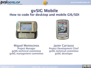
1. gvSIG Mobile
How to code for desktop and mobile GIS/SDI
Miguel Montesinos Javier Carrasco
Project Manager Project Development Chief
gvSIG technical committee gvSIG technical committee
gvSIG management committee gvSIG developer
WEDNESDAY 1 OCT FOSS4G 2008 – Cape Town, South Africa 1
2. Agenda
●
Introduction
● New features in gvSIG Mobile
●
Mobile Devices
●
Java versions
●
J2SE-J2ME Compatibility Tips
●
Take packages from J2SE VMs
●
Use the compatible alternative
● MVC Splitting and dependency injection
WEDNESDAY 1 OCT FOSS4G 2008 – Cape Town, South Africa 2
3. Introduction
Introduction. Prodevelop
● Spanish company, Valencia
●
15 years of GIS experience
●
More than 50 people
● Member of gvSIG dev. team
● High focus on FOSS4G
www.prodevelop.es
WEDNESDAY 1 OCT FOSS4G 2008 – Cape Town, South Africa 3
4. Introduction
Introduction. gvSIG context
● Full-fledged GIS desktop with:
●
Vector/Raster support.
● SDI client (WMS, WMC, WFS, WCS, CSW, ...)
●
Analysis (Sextante project)
●
Edition, projections, adv.symbology, ...
● Going on:
● 3D
●
Network Analysis
●
Raster & remote sensing
● Adv. Analysis
●
4D, Sensor
●
European Union funds until 2013
● Available in 10+ languages
● Around 1.500 users subscribed to lists
WEDNESDAY 1 OCT FOSS4G 2008 – Cape Town, South Africa 4
5. Introduction
Introduction. gvSIG @ FOSS4G2008
● PAL. A Cartographic Labeling Library
●
Olivier Ertz, Maxence Laurent, Daniel Rappo, Abson Sae-
Tang, Eric Taillard. Room 2.6a. TUESDAY 30 SEPT
●
●
Multipurpose metadata management in gvSIG
●
Laura Díaz. Room 2.6a (297). TUESDAY 30 SEPT
●
●
Improving open source GIS-SDI integration: the web service
publishing extension for gvSIG
●
Salvador Bayarri. Room 2.4b (120) THURSDAY 10:30
●
WEDNESDAY 1 OCT FOSS4G 2008 – Cape Town, South Africa 5
6. Introduction
Introduction. gvSIG @ FOSS4G2008
●
●
gvSIG Status Report. Towards an open organization
●
Miguel Montesinos. Room 1.6 (260) THURSDAY 10:30
●
●
A free graphical modeling tool for geospatial analysis
● Victor Olaya. Room 1.6 (260) THURSDAY 10:30
●
●
Introduction to gvSIG/SEXTANTE as desktop GIS with
advanced spatial analysis and SDI publishing tools
●
Victor Olaya, Salvador Bayarri, Jose Vicente Higon, Laura Diaz
●
Workshop CODE: WS-F-8. FRIDAY 13:30
WEDNESDAY 1 OCT FOSS4G 2008 – Cape Town, South Africa 6
8. Introduction
Introduction. gvSIG Mobile
●
gvSIG for mobile devices
●
Developed by:
●
Prodevelop
●
Robotics Institute @ Univ. of Valencia
● IVER
● New version in october
WEDNESDAY 1 OCT FOSS4G 2008 – Cape Town, South Africa 8
14. New Features
●
Edition
● Custom Forms
●
GML
●
KML
●
GPX
●
phoneME Advanced integration
● Easier installation
● Bugfixes
WEDNESDAY 1 OCT FOSS4G 2008 – Cape Town, South Africa 14
15. Mobile Devices
Laptop
PDA
Phone
Smartphone
UMPC
Mini Laptop
WEDNESDAY 1 OCT FOSS4G 2008 – Cape Town, South Africa 15
16. Mobile Devices
Portable PCs Mobile Phones
● Desktop OS ●
Propietary OS
●
Powerful processors ●
Slow processors
●
More than 512 RAM ● Very small memory
●
J2SE ● J2ME CLDC
●
Capable of running ●
Small non.touch screens
gvSIG desktop ●
Too limited for a
complete GIS
WEDNESDAY 1 OCT FOSS4G 2008 – Cape Town, South Africa 16
17. Mobile Devices
PDAs and Smartphones
●
Cheap devices (200€+)
●
Touchscreens (240x360 or more)
●
J2ME CDC PP (Subset of J2SE)
● ARM 400MHz+ processors
●
64-128MB RAM
●
GPRS/UMTS internet
● Camera
● GPS
WEDNESDAY 1 OCT FOSS4G 2008 – Cape Town, South Africa 17
20. Mobile Devices – Java Versions
●
Mobile Phones:
●
CLDC MIDP limited but connected map viewers
●
● Portable PCs:
●
Existing J2SE applications with customized GUIs
●
●
Smartphones and PDAs:
●
J2SE VMs for PDA runned too slow
●
J2ME CDC PP
● New applications
●
Share libraries with desktop applications
WEDNESDAY 1 OCT FOSS4G 2008 – Cape Town, South Africa 20
21. Java Versions – CDC PP
Packages in both J2SE and in J2ME CDC PP
java.util java.io
java.applet java.awt java.lang
java.net java.rmi java.math
java.security java.beans java.text
WEDNESDAY 1 OCT FOSS4G 2008 – Cape Town, South Africa 21
22. Java Versions – CDC PP
Packages in J2SE and NOT in J2ME CDC PP
java.sql
java.awt.geom javax.imageio javax.security
javax.sql
java.awt.dnd java.util.logging javax.sound javax.naming
java.awt.print
java.util.prefs javax.swing javax.net
javax.print
org.w3c.dom
java.nio java.util.regex org.xml javax.rmi
javax.xml
WEDNESDAY 1 OCT FOSS4G 2008 – Cape Town, South Africa 22
23. Java Versions – CDC PP
Packages in J2ME CDC PP and NOT in J2SE
javax.microedition.io
javax.microedition.pki
javax.microedition.xlet
WEDNESDAY 1 OCT FOSS4G 2008 – Cape Town, South Africa 23
24. Java Versions – CDC PP
Other differences with J2SE
● Classes non existent in shared packages
● For example the package java.io lacks
●
LineNumberInputStream
● StringBufferInputStream
WEDNESDAY 1 OCT FOSS4G 2008 – Cape Town, South Africa 24
25. Java Versions – CDC PP
Other differences with J2SE
● Methods non existent in shared classes
●
For example String class lack the methods:
●
getBytes(int srcBegin, int srcEnd, byte[] dst, int dstBegin)
●
matches(String regex)
●
replaceAll(String regex, String replacement)
● replaceFirst(String regex, String replacement)
●
split(String regex)
●
split(String regex, int limit)
WEDNESDAY 1 OCT FOSS4G 2008 – Cape Town, South Africa 25
26. How to code for J2SE and CDC PP
TIPS for compatibility
WEDNESDAY 1 OCT FOSS4G 2008 – Cape Town, South Africa 26
27. J2SE – CDC PP Compatibility Tips
Tip 1
If you need a package just take it
Most VMs allow you to add protected packages
java -Xbootclasspath:myawtgeom.jar ...
There are free implementations of J2SE we can use
WEDNESDAY 1 OCT FOSS4G 2008 – Cape Town, South Africa 27
28. J2SE – CDC PP Compatibility Tips
Tip 1
If you need a package just take it
●
Worked very well to add
●
java.awt.geom
● java.util.regex
We can use only pure java 1.4 code
WEDNESDAY 1 OCT FOSS4G 2008 – Cape Town, South Africa 28
29. J2SE – CDC PP Compatibility Tips
Tip 2
Use the compatible alternative
● Use when possible packages and classes that
exist in both configurations
●
Instead of using SAX or DOM XML parsers use
lightweight pull parsers (ie KXML)
●
Use 3rd party libraries that only depends on packages
existing in both configurations
WEDNESDAY 1 OCT FOSS4G 2008 – Cape Town, South Africa 29
30. J2SE – CDC PP Compatibility Tips
Tip 3
MVC Separation and Dependency Injection
● Controller can to be shared
●
Some Model libraries are compatible and some
others not
●
View never is compatible
●
Dependency Injection allows you to keep some
libraries common and others different
WEDNESDAY 1 OCT FOSS4G 2008 – Cape Town, South Africa 30
31. J2SE – CDC PP Compatibility Tips
Tip 3
MVC Separation and Dependency Injection
Model Controller View
Desktop
Desktop
Application optimized Swing
Libraries DI
DI MDI GUI
Common Common
Libraries Controller
Mobile
Application DI
PDA DI AWT
optimized Simple GUI
Libraries
WEDNESDAY 1 OCT FOSS4G 2008 – Cape Town, South Africa 31
32. J2SE – CDC PP Compatibility Tips
Tip 4
Libraries of frequently used incompatible code
● Libraries with utilities not existing in CDC PP to
be used both in desktop and in mobile
●
Examples:
StringUtils NetworkUtils FileUtils
splitString() getNetFile() getImage()
replaceAll() sendEmail() fileToString()
WEDNESDAY 1 OCT FOSS4G 2008 – Cape Town, South Africa 32
33. Conclussions
●
It's doable to develop GIS with Java for PDAS
●
Ultramobile PCs and Low-Cost Laptops will need new
interfaces for existing desktop GIS applications
●
Java allows real portability of code
●
gvSIG now fits in our pockets
WEDNESDAY 1 OCT FOSS4G 2008 – Cape Town, South Africa 33
37. gvSIG Mobile
How to code for desktop and mobile GIS/SDI
Thank you very much for your attention
Miguel Montesinos Javier Carrasco
mmontesinos@prodevelop.es jcarrasco@prodevelop.es
WEDNESDAY 1 OCT FOSS4G 2008 – Cape Town, South Africa 37