Download to read offline

![https://maps.googleapis.com/maps/api/js?v=3&key=xxxxxxxxx
Google API
https://github.com/googlemaps/google-maps-services-js
https://console.developers.google.com/apis/
• Standard Plan (free)
• Premium Plan (paid) https://maps.googleapis.com/maps/api/js?client=CLIENT_ID&v=3.32&..
CLIENT_ID = gme-[company] & proj-[number] ([type])
//https://github.com/udacity/ud864
Maps java script api](https://image.slidesharecdn.com/apis-180910101103/85/Google-Maps-Api-5-320.jpg)
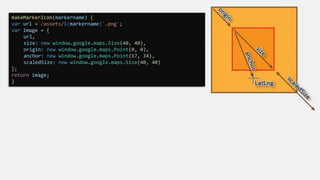
![create Map class
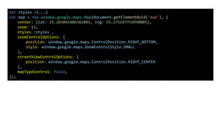
map = new google.maps.Map(document.getElementById('map'), {
center: {lat: 35.5407, lng: 35.7953},
zoom: 13,
mapTypeId : google.maps.MapTypeId.SATELLITE // satellite
});
map = new google.maps.Map( mapDiv [ , opts] ) //opts is MapOptions interface
https://developers.google.com/maps/documentation/javascript/reference
mapTypeId constants :
//add widget as input field to map
map.controls[google.maps.ControlPosition.RIGHT_TOP].push( document.getElementById('bar') );](https://image.slidesharecdn.com/apis-180910101103/85/Google-Maps-Api-7-320.jpg)
![Lat range [-90, 90]
Lng range [-180, 180]
var marker = new google.maps.Marker({
position: {lat: 35.540, lng: 35.79},
title: 'i am anas alpure',
animation: google.maps.Animation.DROP,
id: 10 ,
// map: map,
draggable:true,
icon: image
});
marker.setMap(map);
var bounds = new google.maps.LatLngBounds();
bounds.extend( {lat: 35.540, lng: 35.792});
bounds.extend( {lat:35.5540, lng: 35.790});
LatLngBounds class Methods:
contains
equals
extend
getCenter
getNorthEast
getSouthWest
intersects
isEmpty
toJSON
toSpan
toString
toUrlValue
A LatLngBounds instance represents a rectangle in
geographical coordinates, including one that crosses the
180 degrees longitudinal meridian.
Marker
map.fitBounds(bounds);](https://image.slidesharecdn.com/apis-180910101103/85/Google-Maps-Api-9-320.jpg)
![marker.addListener('click', function() {
var infowindow = new google.maps.InfoWindow();
infowindow.marker = marker;
infowindow.setContent('<div>' + View restaurant + '</div>');
infowindow.open(map, marker);
// Make sure the marker property is cleared if the infowindow is closed.
infowindow.addListener('closeclick', function() {
infowindow.marker = null;
});
});
InfoWindow
The InfoWindow constructor takes an InfoWindowOptions object literal [InfoWindowOptions interface] (optional)
InfoWindowOptions interface Properties:
• content
• disableAutoPan
• maxWidth
• pixelOffset
• position
• zIndex
var infowindow = new google.maps.InfoWindow({
content : '<h1>anas alpure</h1>' ,
maxWidth : 400 ,
position : {lat:35.5540, lng: 35.790}
});](https://image.slidesharecdn.com/apis-180910101103/85/Google-Maps-Api-10-320.jpg)
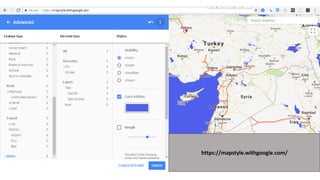
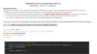
![var styles =
[
{
"featureType": "road.highway",
"elementType": "geometry.fill",
"stylers" : [
{
"color": "#f74d44"
},
{
"visibility": "on"
}
]
},
{
"featureType": "water",
"elementType": "geometry.fill",
"stylers" : [
{
"color": "#4f5fec"
}
]
}
]
map = new google.maps.Map( Div , {styles: styles});
featureType
administrative
landscape
points of interest
road
transit
water
Country
Province
Locality
Neighborhood
Land parcel
Element type :
Geometry
- Fill
- Stroke
Labels
-Text
-- Text fill
-- Text outline
Icon](https://image.slidesharecdn.com/apis-180910101103/85/Google-Maps-Api-15-320.jpg)

![// Initialize the drawing manager
var drawingManager = new google.maps.drawing.DrawingManager({
drawingMode: google.maps.drawing.OverlayType.MARKER,
drawingControl: true,
drawingControlOptions: {
position: google.maps.ControlPosition.TOP_CENTER,
drawingModes: ['marker', 'circle', 'polygon', 'polyline', 'rectangle']
},
markerOptions: {
icon: 'https://developers.google.com/maps/documentation/javascript/examples/full/images/beachflag.png'
},
circleOptions: {
fillColor: '#ffff00',
fillOpacity: 1,
strokeWeight: 5,
clickable: false,
editable: true,
zIndex: 1
}
});
drawingManager.setMap(map);
drawingManager.addListener('polylinecomplete', function(poly) {
console.log ( poly.getPath() )
});
Drawing on the map](https://image.slidesharecdn.com/apis-180910101103/85/Google-Maps-Api-22-320.jpg)
![var map = new google.maps.Map( ... ) ;
var polylineCoordinates = [
{lat: 35.52379969181, lng: 35.782901931} ,
{lat: 35.53057537818, lng: 35.771486450} ,
{lat: 35.51488532952, lng: 35.769038738} ,
{lat: 35.5133365776, lng: 35.784380805} ,
{lat: 35.52379969181, lng: 35.782901931}
];
var polyline = new google.maps.Polyline({
path: polylineCoordinates,
geodesic: true,
strokeColor: '#e46060',
strokeOpacity: 1.0,
strokeWeight: 2
});
polyline.setMap(map);](https://image.slidesharecdn.com/apis-180910101103/85/Google-Maps-Api-23-320.jpg)
![Geocoding web service is the process of converting addresses (like "1600 Amphitheatre Parkway, Mountain
View, CA") into geographic coordinates (like latitude 37.423021 and longitude -122.083739), which you can use
to place markers on a map, or position the map.
Geocoding
https://maps.googleapis.com/maps/api/geocode/outputFormat?parameters
https://maps.googleapis.com/maps/api/geocode/json?
address=1600+Amphitheatre+Parkway,+Mountain+View,+CA&
key=YOUR_API_KEY
https://maps.googleapis.com/maps/api/geocode/json?
latlng=33.1262476,-117.3115765&
key=AIzaffBpEWCjp0C0vtnpvCkouQE0hCjfKXwYoXY
google.maps.Geocoder
{
"results" : [
{
"address_components" : [... ],
"formatted_address" : "1 Legoland Dr, Carlsbad, CA 92008, USA
"geometry" : {
"location" : {
"lat" : 33.1262496,
"lng" : -117.3119239
},
"location_type" : "ROOFTOP",
"viewport" : {
"northeast" : {
"lat" : 33.1275985802915,
"lng" : -117.3105749197085
},
"southwest" : {
"lat" : 33.12490061970851,
"lng" : -117.3132728802915
}
}
},
"place_id" : "ChIJKd0j4hxz3IARYwXlnyp1OhY",
"types" : [ "street_address" ]
}
],
"status" : "OK"
} {}{} …..](https://image.slidesharecdn.com/apis-180910101103/85/Google-Maps-Api-26-320.jpg)
![function zoomToArea(address = ' الجنوبي الكورنيش ' ){
//Initialize the geocoder.
var geocoder = new google.maps.Geocoder();
// Get the address or place that the user entered.
geocoder.geocode(
{ address: address,
componentRestrictions: { country: 'SYRIA'}
} ,
function(results, status) {
if (status == google.maps.GeocoderStatus.OK) {
map.setCenter(results[0].geometry.location);
map.setZoom(15);
} else {
window.alert('We could not find that location - try entering a more' + ' specific place.');
}
}
);
}
• address: string,
• location: LatLng,
• placeId: string,
• bounds: LatLngBounds,
• componentRestrictions:
GeocoderComponentRestrictions,
• region: string
Geocoding](https://image.slidesharecdn.com/apis-180910101103/85/Google-Maps-Api-27-320.jpg)
![Elevation API
https://maps.googleapis.com/maps/api/elevation/outputFormat?parameters
https://maps.googleapis.com/maps/api/elevation/json?locations=39.7391536,-104.9847034&key=YOUR_API_KEY
{
"results" : [
{
"elevation" : 1608.637939453125,
"location" : {
"lat" : 39.73915360,
"lng" : -104.98470340
},
"resolution" : 4.771975994110107
}
],
"status" : "OK"
}
var elevator = new google.maps.ElevationService;
elevator.getElevationForLocations(
{
'locations': {"lat" : 33.96,"lng" : -117.39}
},
function(results, status) { ... }
)](https://image.slidesharecdn.com/apis-180910101103/85/Google-Maps-Api-28-320.jpg)
![function initMap() {
var map = new google.maps.Map(document.getElementById('map'), {
zoom: 8,
center: {lat: 63.333, lng: -150.5}, // Denali.
mapTypeId: 'terrain'
});
var elevator = new google.maps.ElevationService;
var infowindow = new google.maps.InfoWindow({map: map});
map.addListener('click', function(event) {
displayLocationElevation(event.latLng, elevator, infowindow);
});
}
function displayLocationElevation(location, elevator, infowindow) {
elevator.getElevationForLocations({
'locations': [location]
}, function(results, status) {
infowindow.setPosition(location);
if (status === 'OK') {
if (results[0]) {
infowindow.setContent('The elevation at this point <br>is ' +
results[0].elevation + ' meters.');
} else {
infowindow.setContent('No results found');
}
} else {
infowindow.setContent('Elevation service failed due to: ' + status);
}
});
}
Event object](https://image.slidesharecdn.com/apis-180910101103/85/Google-Maps-Api-29-320.jpg)
![var origin1 = new google.maps.LatLng(55.930385, -3.118425);
var origin2 = 'Greenwich, England’;
var origin3 = ‘4800 EL camino real ,los altos , ca’;
var destinationA = ‘2465 lathem street , mountain view ,CA';
var destinationB = new google.maps.LatLng(50.087692, 14.421150);
var service = new google.maps.DistanceMatrixService();
service.getDistanceMatrix(
{
origins: [origin1, origin2],
destinations: [destinationA, destinationB],
travelMode: 'DRIVING',
transitOptions: TransitOptions,
drivingOptions: DrivingOptions,
unitSystem: UnitSystem,
avoidHighways: Boolean,
avoidTolls: Boolean,
}, callback);
function callback(response, status) {
// See Parsing the Results for
console.log(response)
}
Travel Modes :
• BICYCLING
• DRIVING
• TRANSIT
• WALKING
Distance Matrix Service
unitSystem :
google.maps.UnitSystem.METRIC (default)
google.maps.UnitSystem.IMPERIAL](https://image.slidesharecdn.com/apis-180910101103/85/Google-Maps-Api-30-320.jpg)
![var origin = '4800 EL camino real ,los altos , ca';
var destination= '2465 lathem street , mountain view ,CA';
var distanceService = new google.maps.DistanceMatrixService();
distanceService.getDistanceMatrix(
{
origins: [origin],
destinations: [destination],
travelMode: 'BICYCLING',
unitSystem : google.maps.UnitSystem.IMPERIAL
} ,
(response, status)=>{
console.log(response)
}
);](https://image.slidesharecdn.com/apis-180910101103/85/Google-Maps-Api-31-320.jpg)
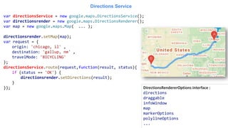
![Google Maps API Directions Service which receives direction requests and returns an efficient path.
Directions Service
{
origin: LatLng | String | google.maps.Place,
destination: LatLng | String | google.maps.Place,
travelMode: TravelMode,
transitOptions: TransitOptions,
drivingOptions: DrivingOptions,
unitSystem: UnitSystem,
waypoints[]: DirectionsWaypoint,
optimizeWaypoints: Boolean,
provideRouteAlternatives: Boolean,
avoidFerries: Boolean,
avoidHighways: Boolean,
avoidTolls: Boolean,
region: String
}
DirectionsRequest interface contains
{
origin: 'Hoboken NJ',
destination: 'Carroll Gardens, Brooklyn',
travelMode: 'TRANSIT',
transitOptions: {
departureTime: new Date(1337675679473),
modes: ['BUS'],
routingPreference: 'FEWER_TRANSFERS'
},
unitSystem: google.maps.UnitSystem.IMPERIAL
}
transitOptions
arrivalTime
departureTime
modes
routingPreference
BUS
RAIL
SUBWAY
TRAIN
TRAM
google.maps.DirectionsService](https://image.slidesharecdn.com/apis-180910101103/85/Google-Maps-Api-32-320.jpg)
![The Directions service can return multi-part directions using a series of waypoints.
Waypoints alter a route by routing it through the specified location(s).
var request = {
origin: 'Florence, IT' ,
destination: 'Milan, IT' ,
travelMode: 'DRIVING',
waypoints: [
{
location: 'Genoa, IT',
stopover: true
},{
location: 'Bologna, IT',
stopover: true
},{
location: 'venice , IT',
stopover: true
}
],
//rearranging the waypoints in a more efficient order.
optimizeWaypoints:true
};
directionsService.route(request,function(result, status){
if (status == 'OK') {
directionsrender.setDirections(result);
}
});
➢ Waypoints are not supported for the TRANSIT travel mode](https://image.slidesharecdn.com/apis-180910101103/85/Google-Maps-Api-34-320.jpg)
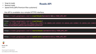
![Roads API
var apiKey ='AIzaffBpEWCjp0C0vtnpvCkouQE0hCjfKXwYoXY';
var pathValues = ['35.27801,149.12958','-35.28032,149.12907','-35.28099,149.12929','-35.28144,149.12984','-35.28282,149.12956']
var snappedCoordinates ;
var placeIdArray ;
$.get('https://roads.googleapis.com/v1/snapToRoads’, { //$ jQuery library
interpolate: true,
key: apiKey,
path: pathValues.join('|')
},
processSnapToRoadResponse
);
// Store snapped polyline returned by the snap-to-road service.
function processSnapToRoadResponse(data) {
snappedCoordinates = [];
placeIdArray = [];
for (var i = 0; i < data.snappedPoints.length; i++) {
var latlng = new google.maps.LatLng(
data.snappedPoints[i].location.latitude,
data.snappedPoints[i].location.longitude
);
snappedCoordinates.push(latlng);
placeIdArray.push(data.snappedPoints[i].placeId);
}
}](https://image.slidesharecdn.com/apis-180910101103/85/Google-Maps-Api-36-320.jpg)
![Placesgoogle.maps.places
google.maps.places.Autocomplete(input, options)
function geolocate() {
if (navigator.geolocation) {
navigator.geolocation.getCurrentPosition(function(position) {
var geolocation = {
lat: position.coords.latitude,
lng: position.coords.longitude
}
var circle = new google.maps.Circle({
center: geolocation,
radius: 3000
});
autocomplete.setBounds(circle.getBounds());
});
}
}
var autocomplete = new google.maps.places.Autocomplete( document.getElementById('search-text-input') ,{
types: ['(cities)'],
componentRestrictions: {country: 'fr’} ,
//bounds: LatLngBounds
});](https://image.slidesharecdn.com/apis-180910101103/85/Google-Maps-Api-37-320.jpg)
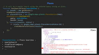
![var placeMarkers=[] ;
function hideMarkers(m){...}
function createMarkersForPlaces(p){...}
var searchBox = new google.maps.places.SearchBox(document.getElementById('places-search'));
// Bias the searchbox to within the bounds of the map.
searchBox.setBounds(map.getBounds());
searchBox.addListener('places_changed', function() {
//hide all marker in placeMarkers
hideMarkers(placeMarkers);
var places = searchBox.getPlaces();
// For each place, get the icon, name and location.
createMarkersForPlaces(places);
if (places.length == 0) {
window.alert('We did not find any places matching that search!');
}
});](https://image.slidesharecdn.com/apis-180910101103/85/Google-Maps-Api-38-320.jpg)
![var request = {
query: 'Museum of Contemporary Art Australia',
fields: ['photos', 'formatted_address', 'name', 'rating', 'opening_hours', 'geometry'],
};
placesService = new google.maps.places.PlacesService(map);
placesService.findPlaceFromQuery( request
, function (results, status) {
if (status == google.maps.places.PlacesServiceStatus.OK) {
createMarkersForPlaces(results);
}
});
Places
placesService.nearbySearch(request, callback);
parameter TextSearch nearbySearch findPlaceFromQuery
query Requered
Location and radius
Or bounds
required
locationBias optional
Location and radius
Or bounds
optional
rankBy optional optional optional
keyword optional optional optional
fields optional optional required](https://image.slidesharecdn.com/apis-180910101103/85/Google-Maps-Api-40-320.jpg)
![Place Details Requests
placesService = new google.maps.places.PlacesService(map);
placesService.getDetails({
placeId: 'ChIJN1t_tDeuEmsRUsoyG83frY4',
fields: ['name', 'rating', 'formatted_phone_number', 'geometry'] //can add photos
}, function (place, status) {
if (status == google.maps.places.PlacesServiceStatus.OK) {
console.log(place);
}
});](https://image.slidesharecdn.com/apis-180910101103/85/Google-Maps-Api-41-320.jpg)

This document discusses various Google Maps APIs and services including: 1. The JavaScript API which allows embedding maps and building mapping applications. 2. Common classes and methods for maps, markers, info windows, and other objects. 3. Additional libraries for geometry, places, and drawing. 4. Services for geocoding, elevation, and static maps. 5. Examples of customizing maps, adding interactivity, and integrating additional location-based features.


![[pgday.Seoul 2022] POSTGRES 테스트코드로 기여하기 - 이동욱](https://cdn.slidesharecdn.com/ss_thumbnails/postgres-221114014538-b9df2ddf-thumbnail.jpg?width=640&height=640&fit=bounds)

![지리정보체계(GIS) - [2] 좌표계 이해하기](https://cdn.slidesharecdn.com/ss_thumbnails/sugis2018c02-180916155653-thumbnail.jpg?width=640&height=640&fit=bounds)


![[pgday.Seoul 2022] PostgreSQL구조 - 윤성재](https://cdn.slidesharecdn.com/ss_thumbnails/pgday2022-postgresql-20221112-221114014106-bbfb1955-thumbnail.jpg?width=640&height=640&fit=bounds)