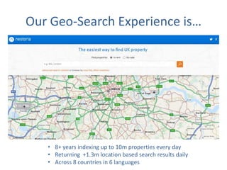
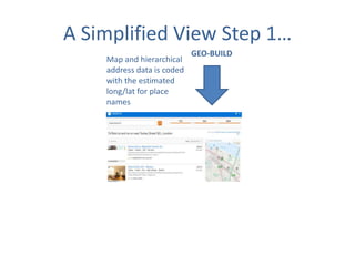
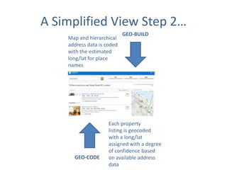
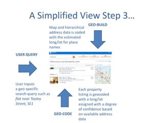
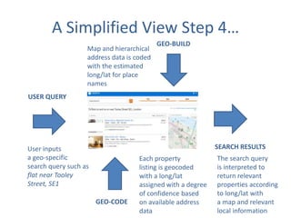
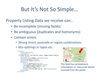
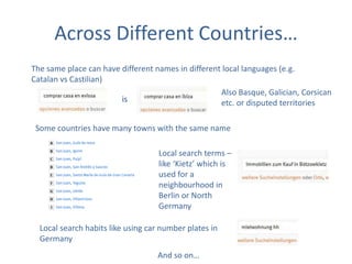
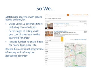
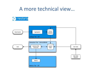
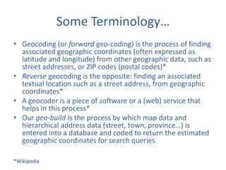
This document summarizes a company's experience providing location-based search services using proprietary geocoding software. The company has 8+ years of experience indexing millions of properties daily and returning search results across 8 countries and 6 languages. It geocodes data using open sources like OpenStreetMap and then matches user search queries to relevant listings based on coordinates. This involves handling ambiguous, incomplete or incorrect data as well as cultural and linguistic differences across countries.
2. Our Geo-Search Experience is…
• 8+ years indexing up to 10m properties every day
• Returning +1.3m location based search results daily
• Across 8 countries in 6 languages
3. A Simplified View Step 1…
Map and hierarchical
address data is coded
with the estimated
long/lat for place
names
GEO-BUILD
4. A Simplified View Step 2…
Map and hierarchical
address data is coded
with the estimated
long/lat for place
names
GEO-CODE
GEO-BUILD
Each property
listing is geocoded
with a long/lat
assigned with a degree
of confidence based
on available address
data
5. A Simplified View Step 3…
Map and hierarchical
address data is coded
with the estimated
long/lat for place
names
GEO-BUILD
USER QUERY
User inputs
a geo-specific
search query such as
flat near Tooley
Street, SE1
GEO-CODE
Each property
listing is geocoded
with a long/lat
assigned with a degree
of confidence based
on available address
data
6. A Simplified View Step 4…
Map and hierarchical
address data is coded
with the estimated
long/lat for place
names
GEO-BUILD
USER QUERY
SEARCH RESULTS
User inputs
a geo-specific
search query such as
flat near Tooley
Street, SE1
GEO-CODE
Each property
listing is geocoded
with a long/lat
assigned with a degree
of confidence based
on available address
data
The search query
is interpreted to
return relevant
properties according
to long/lat with
a map and relevant
local information
7. But It’s Not So Simple…
Property Listing Data we receive can..
• Be incomplete (missing fields)
• Be ambiguous (duplicates and homonyms)
• Contain errors
• Wrong street, postcode or region combinations
• Mis-spellings or typos etc.
This feed has contradictory
information i.e. inaccurate details
received from the portal
8. Geocoding Needs …
Good Map Data
BUT
Map Data can be:
• Very expensive
• Of varying quality
• Unavailable in places like India and Brazil
9. And A Good Geocoder…
is often …
• Very expensive
• Requires good source input data
• Of varying accuracy
• Subject to restrictive terms of use and rate
limits
See also: http://www.theguardian.com/technology/2014/jan/13/google-maps-geocoder
10. What We Do Is…
Geocode using our proprietary software and
tools
• Using OpenStreetMap
• Using other open data sources
• Layering several different open and proprietary
data sets to match a place to a long/lat (termed
forward geocoding) based on available address
data
• Attach degrees of confidence to the match
11. But Then We Get User Queries…
Searchers don’t agree on the name for a place
VS
Use colloquial, not official names
Misspell or
mistype names
Use
abbreviations
Have different ideas of what near to.. means
And so on…
12. Across Different Countries…
The same place can have different names in different local languages (e.g.
Catalan vs Castilian)
Also Basque, Galician, Corsican
is
etc. or disputed territories
Some countries have many towns with the same name
Local search terms –
like ‘Kietz’ which is
used for a
neighbourhood in
Berlin or North
Germany
Local search habits like using car number plates in
Germany
And so on…
13. So We…
Match user searches with places
based on long/lat
• Using up to 15 different filters
including common typos
• Serve pages of listings with
geo coordinates near to the
searched for place
• Provide further heuristic filters
for house type,price, etc.
Backed by a continual programme
of testing and refining our
geocoding accuracy
15. This Could Be Relevant To You …
If your users search for
•
•
•
•
‘Hotel near …’
‘Supermarket near …’
‘Click and Collect near …’
‘Restaurant near…’ etc.
• Using colloquial names or ambiguous queries or
searches near ‘landmarks’ or ‘streets’ etc.
• And your current solution only accepts towns or
postcodes and/or returns approximate answers
16. We Could Help..
Improve user satisfaction with your site search
by:
• Providing access to our geocoding technology
• To forward geocode site searches and match these
to the relevant results
• Enabling you to return more relevant search
results for users that are searching using language
that makes sense to them
17. A couple of comments…
• We are experts in forward geocoding names
or street addresses to a long/lat
• BUT NOT in reverse geocoding names or street
address from a long/lat
• We can share our expertise across the 8
countries where Nestoria currently operates
and also use these skills for other countries
18. Some Terminology…
• Geocoding (or forward geo-coding) is the process of finding
associated geographic coordinates (often expressed as
latitude and longitude) from other geographic data, such as
street addresses, or ZIP codes (postal codes)*
• Reverse geocoding is the opposite: finding an associated
textual location such as a street address, from geographic
coordinates*
• A geocoder is a piece of software or a (web) service that
helps in this process*
• Our geo-build is the process by which map data and
hierarchical address data (street, town, province…) is
entered into a database and coded to return the estimated
geographic coordinates for search queries
*Wikipedia
21. Parent company of OpenCage Data and property search engine Nestoria
Founded 2006 by 2 senior Yahoo! Search Executives
Serving clients globally from Clerkenwell, London
Team of 15 - experts in aggregation, all things geo, local search (ex. Yahoo!, Nokia)
UK Open Data Institute Member
Organize #geomob - quarterly meetup of location based service developers
http://geomobldn.org
Learn more: http://www.lokku.com
22. Residential property search engine
Operates in 8 markets: Australia, Brazil, France, Germany, India, Italy, Spain, UK
3 million unique users searching for >10 million places every month
Extensive experience in geocoding, local search, local SEM
First-mover in using OSM as alternative to Google Maps: http://bit.ly/1a0sopt
Learn more: http://www.nestoria.com
24. OpenStreetMap
The Free Wiki World Map
Collaborative project to create a free, editable map of the world
Started in 2004 by Steve Coast in London
1.4 million registered participants
2+ billion data points, growing continually
Data available under Open Data Commons Open Database License (ODbL).
http://www.openstreetmap.org/copyright
Learn more: http://www.openstreetmap.org/about